干旱区研究 ›› 2024, Vol. 41 ›› Issue (10): 1778-1788.doi: 10.13866/j.azr.2024.10.15
金晨阳1( ), 杜宏茹2()
收稿日期:2024-03-25
修回日期:2024-06-03
出版日期:2024-10-15
发布日期:2024-10-14
通讯作者:
杜宏茹. E-mail: duhongru@sina.com作者简介:金晨阳(1999-),女,硕士研究生,主要从事土地资源管理. E-mail: j7j7cycy@163.com
基金资助:
JIN Chenyang1(), DU Hongru2()
Received:2024-03-25
Revised:2024-06-03
Published:2024-10-15
Online:2024-10-14
摘要:
本文围绕韧性发生的过程和耕地系统提升韧性所要具备的能力,建立了一套适用于干旱区的耕地系统韧性评价指标体系,旨在将韧性理论应用到耕地系统中,评价新疆耕地系统韧性以及20 a间时空演变特征,提出在韧性视角下新疆耕地可持续利用的政策建议。以栅格网格为尺度,使用综合指数法对新疆耕地系统韧性水平进行测算。结果表明:(1) 2000—2020年新疆耕地面积呈增加态势,其主要分布在水资源丰沛的区域;(2) 新疆耕地系统韧性有小幅度的提升,但整体水平仍偏低,且空间异质性强,20 a间高值区呈现向南部转移的趋势,且主要分布于大河冲积形成的河谷三角洲地带;(3) 20 a间新疆耕地系统的抵御能力和适应能力均有所提高,但转型能力有所下降。在空间分布上,南疆地区耕地的抵御能力和转型能力不断提高,适应能力基本呈现“北高南低”的分布格局。由于影响各地区耕地系统韧性的因素不同,因此,根据2020年耕地系统韧性值将耕地利用系统分为5个分区,并针对每个分区面临的问题,提出了具体提升方案,为今后区域内的耕地可持续利用发展提供参考。
金晨阳, 杜宏茹. 新疆耕地系统韧性时空变化特征及其分区划定[J]. 干旱区研究, 2024, 41(10): 1778-1788.
JIN Chenyang, DU Hongru. Characteristics of spatial and temporal changes and zoning of cultivated land resilience in Xinjiang[J]. Arid Zone Research, 2024, 41(10): 1778-1788.
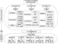
图1
干旱区耕地韧性评价研究框架"

表1
耕地系统韧性评价指标体系"
| 目标层 | 准则层(权重) | 指标层(权重) | 计算方式 | 指标属性 |
|---|---|---|---|---|
| 耕地系统韧性 | 抵御能力(0.6870) | 土壤厚度/cm(0.0340) | 栅格数据 | ﹢ |
| 土壤水分/(m3·m-3)(0.0257) | 栅格数据 | ﹢ | ||
| 土壤pH值(0.0705) | 栅格数据 | 中间型 | ||
| 耕地侵蚀程度(0.0967) | 栅格数据 | - | ||
| 沙化耕地占比/%(0.0697) | 耕地沙化扩大面积/耕地面积 | - | ||
| 有效灌溉耕地比例/%(0.2483) | 有效灌溉面积/耕地面积 | ﹢ | ||
| 单位耕地水利设施(0.1420) | 水库坑塘和河渠水域面积/耕地面积 | ﹢ | ||
| 适应能力(0.1265) | 坡度/(°)(0.0109) | 栅格数据 | - | |
| 起伏度/(°)(0.0203) | 栅格数据 | - | ||
| 高程/km(0.0075) | 栅格数据 | - | ||
| NPP(植被净初级生产指数)(0.0237) | 栅格数据 | ﹢ | ||
| 单位耕地化肥施用强度/(t·hm-2)(0.0305) | 化肥使用量/耕地面积 | - | ||
| 粮食自给率(0.0337) | 粮食总产量÷(总人数×400 kg·人-1) | ﹢ | ||
| 转型能力(0.1865) | 耕地集中连片度(0.0298) | 使用Fragstats 4.2计算 | ﹢ | |
| 单位耕地农业机械化水平/(kW·hm-2)(0.0444) | 农业机械总动力/耕地面积 | ﹢ | ||
| 耕地面积变化率(0.0079) | 两期耕地面积差/基期耕地面积 | ﹢ | ||
| 耕地地均农业产值/(104元·hm-2)(0.0228) | 农业产值(不含林牧渔业)/耕地面积 | ﹢ | ||
| 农业劳动生产率/(104元·人-1)(0.0266) | 农业产值(不含林牧渔业)/农业从业人口 | ﹢ | ||
| 农业生产结构(0.0308) | 经济作物面积/农作物播种面积 | ﹢ | ||
| 复种指数(0.0096) | 农作物播种面积/耕地面积 | ﹢ | ||
| 粮食单产/(kg·hm-2)(0.0050) | 粮食总产量/粮食播种面积 | ﹢ | ||
| 经济作物单产/(kg·hm-2)(0.0095) | 经济作物总产量/经济作物播种面积 | ﹢ |
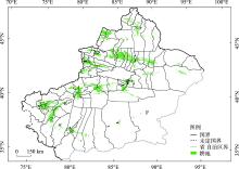
图2
新疆耕地分布示意图 注:底图采用新疆维吾尔自治区自然资源厅标准地图制作,审图号为新S(2021)047号,对底图边界无修改。下同。"
表2
数据来源"
| 名称 | 类型 | 来源 |
|---|---|---|
| 土地利用 | 栅格数据 | 土地利用遥感监测数据(CNLUCC) |
| 起伏度数据 | 栅格数据 | 国家地球系统科学数据共享服务中心 |
| 土壤属性数据 | 栅格数据 | 国家地球系统科学数据中心土壤分中心 |
| DEM、NPP、耕地侵蚀空间分布数据 | 栅格数据 | 中国科学院资源环境科学与数据中心 |
| 行政区划 | 矢量数据 | 中国科学院资源环境科学与数据中心 |
| 经济社会数据 | 统计数据 | 《新疆统计年鉴》《中国统计年鉴》(2001年、2021年) |
表3
新疆耕地系统韧性评价结果(2000—2020年)"
| 韧性 | 抵御能力 | 适应能力 | 转型能力 | ||||||||
|---|---|---|---|---|---|---|---|---|---|---|---|
| 2000年 | 2020年 | 2000年 | 2020年 | 2000年 | 2020年 | 2000年 | 2020年 | ||||
| 最大值 | 0.291 | 0.300 | 0.440 | 0.452 | 0.184 | 0.193 | 0.124 | 0.118 | |||
| 最小值 | 0.125 | 0.128 | 0.146 | 0.166 | 0.038 | 0.051 | 0.041 | 0.046 | |||
| 平均值 | 0.228 | 0.232 | 0.332 | 0.338 | 0.114 | 0.127 | 0.087 | 0.078 | |||
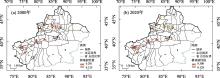
图3
2000—2020年新疆耕地系统韧性空间演变"

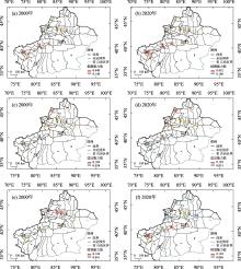
图4
2000—2020年新疆耕地系统韧性能力值时空演变"

表4
耕地系统韧性分区划定规则"
| 分区 | 基本特征 | 对应的 叠加数值 |
|---|---|---|
| 现状维持区 | 抵御能力、适应能力、转型能力均高 | 222 |
| 综合提升区 | 抵御能力、适应能力、转型能力均低 | 111 |
| 抵御能力提升区 | 抵御能力低,适应能力、转型能力高 | 112,121,122 |
| 适应能力提升区 | 适应能力低,抵御能力、转型能力高 | 212 |
| 转型能力提升区 | 转型能力低,抵御能力、适应能力高 | 211,221 |
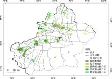
图5
基于韧性的新疆耕地系统分区"

| [1] | 孔祥斌, 陈文广, 党昱譞. 中国耕地保护现状、挑战与转型[J]. 湖南师范大学社会科学学报, 2023, 52(5): 31-41. |
| [Kong Xiangbin, Chen Wenguang, Dang Yuxuan. Current situation, challenges and transformation of cultivated land protection in China[J]. Journal of Science of Hunan Normal University, 2023, 52(5): 31-41.] | |
| [2] | 胡林影, 郭杰, 欧名豪, 等. 耕地系统保护的“刚性—弹性—韧性”: 理论框架与实施路径[J]. 规划师, 2023, 39(11): 7-13. |
| [Hu Linying, Guo Jie, Ou Minghao, et al. The “Rigidity-elasticity-resilience” of systematic farmland protection: Theoretical framework and implementation path[J]. Planners, 2023, 39(11): 7-13.] | |
| [3] | 第三次全国国土调查主要数据成果发布[N]. 人民日报, 2021-08-27( 017). |
| [Major Data Results of the Third National Land Survey were Released[N]. People’s Daily, 2021-08-27( 017).] | |
| [4] | 郧文聚, 汤怀志, 桑玲玲. 树立耕地系统认知, 完善最严格耕保制度[J]. 中国土地, 2022(5): 4-7. |
| [Yun Wenju, Tang Huaizhi, Sang Lingling. Establish a systematic understanding of cultivated land and perfect the strictest farming security system[J]. China Land, 2022(5): 4-7.] | |
| [5] | 王学, 李秀彬, 宋恒飞. 我国耕地撂荒问题分析及其对策研究[J]. 中国土地, 2023(2): 15-17. |
| [Wang Xue, Li Xiubin, Song Hengfei. Analysis and countermeasure research on cultivated land abandonment in China[J]. China Land, 2023(2): 15-17.] | |
| [6] | 谷国政, 宋戈. 辽宁省耕地多功能演变及其价值响应研究[J]. 中国土地科学, 2022(12): 103-116. |
| [Gu Guozheng, Song Ge. Study on the evolution of cultivated land multifunction and its value response in Liaoning Province[J]. China Land Science, 2022(12): 103-116.] | |
| [7] |
孟丽君, 黄灿, 陈鑫, 等. 曲周县耕地利用系统韧性评价[J]. 资源科学, 2019, 41(10): 1949-1958.
doi: 10.18402/resci.2019.10.16 |
|
[Meng Lijun, Huang Can, Chen Xin, et al. Evaluation of cultivated land system resilience of Quzhou County[J]. Resources Science, 2019, 41(10): 1949-1958.]
doi: 10.18402/resci.2019.10.16 |
|
| [8] | 吕晓, 王亚男, 王柏源. 韧性理论视角下耕地利用与保护的若干思考[J]. 中国土地, 2022(5): 16-19. |
| [Lyu Xiao, Wang Yanan, Wang Boyuan. Some thoughts on the utilization and protection of cultivated land from the perspective of resilience theory[J]. China Land, 2022(5): 16-19.] | |
| [9] |
苗欣然, 李泽红, 王梦媛. 粮食供应安全下东北黑土区耕地利用系统韧性时空演变——以齐齐哈尔市为例[J]. 资源科学, 2023, 45(9): 1801-1816.
doi: 10.18402/resci.2023.09.08 |
|
[Miao Xinran, Li Zehong, Wang Mengyuan. Spatiotemporal changes of cultivated land use system resilience in the black soil region of Northeast China under food supply security: A case study of Qiqihar City[J]. Resources Science, 2023, 45(9): 1801-1816.]
doi: 10.18402/resci.2023.09.08 |
|
| [10] | 李窚琪, 张翊, 付保红, 等. 昆明市耕地韧性评价及空间差异[J]. 科学技术与工程, 2021, 21(12): 4848-4855. |
| [Li Chengqi, Zhang Yi, Fu Baohong, et al. Resilience evaluation and spatial difference of cultivated land system in Kunming[J]. Science Technology and Engineering, 2021, 21(12): 4848-4855.] | |
| [11] | Lyu X, Wang Y N, Niu S D, et al. Spatio-temporal pattern and influence mechanism of cultivated land system resilience: Case from China[J]. Land, 2021, 11(1): 11. |
| [12] | Xu W Y, Jin X B, Liu J, et al. Spatio-temporal evolution and the detection of key drivers in the resilience of cultivated land system in major grain-producing regions of China[J]. Land Degradation and Development, 2023, 34(15): 4712-4727. |
| [13] | 李玉恒, 黄惠倩, 郭桐冰, 等. 多重压力胁迫下东北黑土区耕地韧性研究及其启示——以黑龙江省拜泉县为例[J]. 中国土地科学, 2022, 36(5): 71-79. |
| [Li Yuheng, Huang Huiqian, Guo Tongbing, et al. Research on cultivated land resilience of the black soil region in the Northeast China under multiple stresses and its implications: The study of Baiquan County, Heilongjiang Province[J]. China Land Science, 2022, 36(5): 71-79.] | |
| [14] | 熊昌盛, 张永蕾, 王雅娟, 等. 中国耕地多功能评价及分区管控[J]. 中国土地科学, 2021, 35(10): 104-114. |
| [Xiong Changsheng, Zhang Yonglei, Wang Yajuan, et al. Multi-function evaluation and zoning control of cultivated land in China[J]. China Land Science, 2021, 35(10): 104-114.] | |
| [15] | 徐磊, 胡浩, 尹士, 等. 河北省耕地功能供需转型时空演变及利用分区[J]. 水土保持研究, 2023, 30(3): 403-412. |
| [Xu Lei, Hu Hao, Yin Shi, et al. Spatiotemporal evolution and subarea of cultivated fuction supply-demand transition in Hebei Province[J]. Research of Soil and Water Conservation, 2023, 30(3): 403-412.] | |
| [16] | 张金懿, 郝晋珉, 王楠, 等. 山东省耕地质量空间自相关分析与耕地保护分区研究[J]. 土壤通报, 2023, 54(4): 757-767. |
| [Zhang Jinyi, Hao Jinmin, Wang Nan, et al. Protection zoning of cultivated land based on spatial autocorrelation in Shandong Province[J]. Chinese Journal of Soil Science, 2023, 54(4): 757-767.] | |
| [17] | 孙晓兵, 蔡为民, 孔祥斌, 等. 基于多元主体协同的县域耕地质量调控模式与整治时序分区[J]. 农业工程学报, 2023, 39(21): 232-245. |
| [Sun Xiaobing, Cai Weimin, Kong Xiangbin, et al. Quality regulation pattern and consolidation time zone of county-level cultivated land based on multi agent collaboration[J]. Transactions of the Chinese Society of Agricultural Engineering, 2023, 39(21): 232-245.] | |
| [18] |
朱晓华, 张燕, 朱媛媛. 大食物观视角下中国耕地保护的分区调控与区间协同[J]. 地理学报, 2023, 78(9): 2147-2162.
doi: 10.11821/dlxb202309003 |
|
[Zhu Xiaohua, Zhang Yan, Zhu Yuanyuan. Regional regulation and interregional coordination of cultivated land protection in China from the perspective of “Greater Food” approach[J]. Acta Geographica Sinica, 2023, 78(9): 2147-2162.]
doi: 10.11821/dlxb202309003 |
|
| [19] |
李菲菲, 周霞, 周玉玺. 西北地区农业干旱脆弱性评估及时空分布特征[J]. 干旱区研究, 2023, 40(4): 663-669.
doi: 10.13866/j.azr.2023.04.15 |
|
[Li Feifei, Zhou Xia, Zhou Yuxi. Vulnerability assessment and spatiotemporal distribution of agricultural drought in Northwest China[J]. Arid Zone Research, 2023, 40(4): 663-669.]
doi: 10.13866/j.azr.2023.04.15 |
|
| [20] |
薛一波, 黄双燕, 张小啸, 等. 新疆2018年冬季雨雪风沙强降尘事件[J]. 干旱区研究, 2023, 40(5): 681-690.
doi: 10.13866/j.azr.2023.05.01 |
|
[Xue Yibo, Huang Shuangyan, Zhang Xiaoxiao, et al. Study on the strong winter airborne dustfall mixed rain and snow events in Xinjiang, China in 2018[J]. Arid Zone Research, 2023, 40(5): 681-690.]
doi: 10.13866/j.azr.2023.05.01 |
|
| [21] | 邢策. 商品粮主产区黑龙江省粮食综合生产能力提升研究[D]. 哈尔滨: 东北林业大学, 2021. |
| [Xing Ce. Research on the Promotion of Comprehensive Grain Production Capacity in the Main Gain Producing Areas of Commodity Grain Heilongjiang Province[D]. Harbin: Northeast Forestry University, 2021.] | |
| [22] |
潘雪, 关宇淇, 潘占东, 等. 干旱区耕地质量等级时空变化及其评价——以西宁市为例[J]. 干旱区地理, 2023, 46(5): 793-803.
doi: 10.12118/j.issn.1000-6060.2022.393 |
|
[Pan Xue, Guan Yuqi, Pan Zhandong, et al. Spatiotemporal variation and evaluation of cultivated land quality grade in arid areas: A case of Xining City[J]. Arid Land Geography, 2023, 46(5): 793-803.]
doi: 10.12118/j.issn.1000-6060.2022.393 |
|
| [23] | 李超, 赵洋, 杨翠翠, 等. 基于耕地资源质量分类成果的东北地区耕地土壤条件空间分布特征[J]. 土壤通报, 2024, 55(3): 601-609. |
| [Li Chao, Zhao Yang, Yang Cuicui, et al. Spatial distribution characteristics of cultivated land soil conditions in Northeast China based on cultivated land resource quality classification[J]. Chinese Journal of Soil Science, 2024, 55(3): 601-609.] | |
| [24] |
赵蒙恩, 闫庆武, 刘政婷, 等. 鄂尔多斯市土壤侵蚀时空演变及影响因子分析[J]. 干旱区研究, 2022, 39(6): 1819-1831.
doi: 10.13866/j.azr.2022.06.12 |
|
[Zhao Mengen, Yan Qingwu, Liu Zhengting, et al. Analysis of temporal and spatial evolution and influencing factors of soil erosion in Ordos City[J]. Arid Zone Research, 2022, 39(6): 1819-1831.]
doi: 10.13866/j.azr.2022.06.12 |
|
| [25] |
张红旗, 李达净. 西北干旱区不稳定耕地概念与分类研究——以新疆昌吉州为例[J]. 地理研究, 2021, 40(3): 597-612.
doi: 10.11821/dlyj020200846 |
| [Zhang Hongqi, Li Dajing. Concept and classification of unstable farmland in arid area of Northwest China: A case study of Changji Prefecture, Xinjiang[J]. Geographical Research, 2021, 40(3): 597-612.] | |
| [26] |
杨航, 侯景伟, 马彩虹, 等. 黄河上游生态脆弱区复合生态系统韧性时空分异——以宁夏为例[J]. 干旱区研究, 2023, 40(2): 303-312.
doi: 10.13866/j.azr.2023.02.14 |
|
[Yang Hang, Hou Jingwei, Ma Caihong, et al. Spatio-temporal differentiation of the composite ecosystem resilience in the ecologically fragile area in the upper reaches of the Yellow River: A case study in Ningxia[J]. Arid Zone Research, 2023, 40(2): 303-312.]
doi: 10.13866/j.azr.2023.02.14 |
|
| [27] | 李文龙, 林海英, 匡文慧. 北方农牧交错区乡村农牧户适应性演化机制——以内蒙古达茂旗农牧户为例[J]. 经济地理, 2020, 40(1): 150-163. |
| [Li Wenlong, Lin Haiying, Kuang Wenhui. Adaptability evolution mechanism of farmers and herdsmen of village in north agricultural-pastoral ecotone: Take Damao Banner in Inner Mongolia as an example[J]. Econamic Geography, 2020, 40(1): 150-163.] | |
| [28] |
刘一丹, 姚晓军, 李宗省, 等. 气候变化和土地利用覆盖变化对河西地区植被净初级生产力的影响[J]. 干旱区研究, 2024, 41(1): 169-180.
doi: 10.13866/j.azr.2024.01.16 |
|
[Liu Yidan, Yao Xiaojun, Li Zongxing, et al. Impacts of climate change and land use/cover change on the net primary productivity of vegetation in Hexi Region, Northwest China[J]. Arid Zone Research, 2024, 41(1): 169-180.]
doi: 10.13866/j.azr.2024.01.16 |
|
| [29] | 高佳, 杨宇. 东北粮食主产区耕地利用绿色转型的时空格局及驱动因素[J]. 中国土地科学, 2023, 37(10): 114-123, 134. |
| [Gao Jia, Yang Yu. Spatial-temporal patterns and driving factors of green transformation for cultivated land use of major grain-producing areas in northeastern China[J]. China Land Science, 2023, 37(10): 114-123, 134.] | |
| [30] | 庞晓菲, 陆汝成, 李思旗, 等. 广西边境地区耕地多功能时空分异格局与集聚特征分析[J]. 中国农业资源与区划, 2023, 44(7): 49-59. |
| [Pang Xiaofei, Lu Rucheng, Li Siqi, et al. Analysis of multi-fuctional temporal and spatial differentiation pattern and agglomeration charcteristics of cultivated land in Guangxi border areas[J]. Chinese Journal of Agricultural Resources and Regional Planning, 2023, 44(7): 49-59.] | |
| [31] | 谭智元, 黄玉莉, 曹银贵, 等. 中国耕地利用转型研究;热点与前沿[J]. 农业资源与环境学报, 2023, 40(6): 1400-1414. |
| [Tan Zhiyuan, Huang Yuli, Cao Yingui, et al. Research on the transformation of cultivated land use in China: Hotspots and frontiers[J]. Journal of Agricultural Resources and Environment, 2023, 40(6): 1400-1414.] | |
| [32] |
周贵鹏, 龙花楼, 戈大专, 等. 耕地利用隐性形态三维测度及其地域类型研究——以黄淮海地区为例[J]. 地理研究, 2024, 43(1): 180-199.
doi: 10.11821/dlyj020230392 |
| [Zhou Guipeng, Long Hualou, Ge Dazhuan, et al. Study on three-dimensional measurement of recessive farmland use morphology and its regional types: A case of the Huang-Huai-Hai Regiong[J]. Geographical Research, 2024, 43(1): 180-199.] | |
| [33] | 陈帷胜, 冯秀丽, 马仁锋, 等. 耕地破碎度评价方法与实证研究——以浙江省宁波市为例[J]. 中国土地科学, 2016, 30(5): 80-87. |
| [Chen Weisheng, Feng Xiuli, Ma Renfeng, et al. Method of cultivated land fragmentation evaluation and empirical research: A case of Ningbo City in Zhejiang Province[J]. China Land Science, 2016, 30(5): 80-87.] | |
| [34] | Marlin D, Lamont B T, Hoffman J J. Choice situation, strategy, and performance: A reexamination[J]. Strategic Management Journal, 1994, 15(3): 229-239. |
| [35] |
张智斌, 范燕敏, 武红旗, 等. 新疆阿勒泰地区耕地质量评价及障碍因素诊断[J]. 新疆农业科学, 2022, 59(7): 1786-1794.
doi: 10.6048/j.issn.1001-4330.2022.07.026 |
| [Zhang Zhibin, Fan Yanmin, Wu Hongqi, et al. Study on evaluation cultivated land quality and diagnosis of obstacle factor in Altay Region, Xinjiang[J]. Xinjiang Agricultural Science, 2022, 59(7): 1786-1794.] |
| [1] | 孙琳琳, 刘琼, 黄观, 陈勇航, 魏鑫, 郭玉琳, 张太西, 高天一, 许赟红. 新疆和周边“一带一路”地区不同云天条件下地表太阳辐射[J]. 干旱区研究, 2024, 41(9): 1480-1490. |
| [2] | 杨晓玲, 周华, 陈静, 赵慧华, 吴雯. 河西走廊东部不同气候态气温变化及其对气候评价的影响[J]. 干旱区研究, 2024, 41(7): 1089-1098. |
| [3] | 菅政博, 罗浩, 单娜娜. “双碳”目标下新疆“三生”空间时空演变特征及碳效应[J]. 干旱区研究, 2024, 41(7): 1238-1248. |
| [4] | 侯嘉烨, 李建华, 王佳蓉, 马海涛, 强泽楷, 樊新刚. 基于SA-RSEI模型的盐池县生态质量演变研究[J]. 干旱区研究, 2024, 41(6): 1045-1058. |
| [5] | 柳华清, 王博, 贾妍妍, 解欣然, 张维. 新疆西天山峡谷不同坡位野核桃冻害特征[J]. 干旱区研究, 2024, 41(6): 1079-1088. |
| [6] | 马元植, 覃小林, 凌红波, 闫俊杰, 张广朋. 1991—2020年新疆中小湖泊面积变化时空特征及趋势分析[J]. 干旱区研究, 2024, 41(6): 905-916. |
| [7] | 张皓哲, 薛亚永, 马圆圆, 薛国玄. 新疆绿洲生态系统固碳潜力研究[J]. 干旱区研究, 2024, 41(6): 998-1009. |
| [8] | 白事麟, 吕雅雅, 师小军. 不同生境和基质对经过牛消化道的新疆野苹果种子萌发和幼苗生长的影响[J]. 干旱区研究, 2024, 41(5): 821-829. |
| [9] | 桑一铭, 辛良杰. 2000—2020年“一江两河”地区耕地集约利用变化[J]. 干旱区研究, 2024, 41(5): 843-855. |
| [10] | 许超杰, 窦燕, 孟琪琳. 基于EMD-GWO-LSTM模型的新疆标准化降水蒸散指数预测方法研究[J]. 干旱区研究, 2024, 41(4): 527-539. |
| [11] | 司琪, 樊浩然, 董文明, 刘新平. 新疆叶尔羌河流域景观生态风险评价及预测[J]. 干旱区研究, 2024, 41(4): 684-696. |
| [12] | 包佳玉, 李祥龙, 胡启文, 李涛. 新疆能源消费碳排放时空特征及能源结构调整路径探讨[J]. 干旱区研究, 2024, 41(3): 490-498. |
| [13] | 姚俊强. 新疆空中水资源和地表水资源变化特征研究[J]. 干旱区研究, 2024, 41(2): 181-190. |
| [14] | 许赟红, 刘琼, 陈勇航, 魏鑫, 刘鑫, 张太西, 邵伟玲, 杨何群, 张丞铭. 新疆及周边中亚地区土地覆盖变化对地表反照率的影响[J]. 干旱区研究, 2024, 41(10): 1649-1661. |
| [15] | 李小锋, 惠婷婷, 李耀明, 毛洁菲, 王光宇, 范连连. 不同放牧管理方式对新疆山地草原植物群落特征的影响[J]. 干旱区研究, 2024, 41(1): 124-134. |
|
||