干旱区研究 ›› 2025, Vol. 42 ›› Issue (1): 40-50.doi: 10.13866/j.azr.2025.01.04 cstr: 32277.14.AZR.20250104
邹彬1,2( ), 邹珊2,3,4(), 杨余辉1
收稿日期:2024-10-06
修回日期:2024-11-08
出版日期:2025-01-15
发布日期:2025-01-17
通讯作者:
邹珊. E-mail: zoushan@ms.xjb.ac.cn作者简介:邹彬(2000-),男,硕士研究生,主要从事干旱区水文过程研究. E-mail: zoubin0304@163.com
基金资助:
ZOU Bin1,2(), ZOU Shan2,3,4(), YANG Yuhui1
Received:2024-10-06
Revised:2024-11-08
Published:2025-01-15
Online:2025-01-17
摘要:
新疆拥有独特的山地-绿洲-荒漠生态系统,其中地表水体是维持生态平衡和支持区域经济社会发展的核心要素。本研究利用Landsat 5/7/8/9卫星遥感影像,运用混合指数算法对1990—2023年新疆地表水体面积进行计算,并分析其空间格局及变化特征。同时,采用地理探测器方法揭示了影响地表水体面积变化的因素。结果表明:1990—2023年新疆永久性水体面积增加了36.25%(2466.20 km2),主要由山地水体主导,特别是羌塘高原内陆河流域显著扩张,增加约三分之二(1149.58 km2);季节性水体面积则增长了181.90%(1924.84 km2),以绿洲-荒漠水体为主,其中塔里木河干流尤为突出,面积增加约两倍(344.92 km2)。山地水体的变化主要受到气候因素的影响,其中雪水当量的平均贡献率最高,达到42.84%;而人类活动对绿洲-荒漠水体的影响则较大,人口密度和耕地的平均贡献率分别为64.10%和54.43%。本研究全面分析了新疆地表水体的时空变化特征及其驱动因素,为科学评估新疆水资源开发潜力及制定合理的水资源管理策略提供了一定的科学依据。
邹彬, 邹珊, 杨余辉. 1990—2023年新疆地表水体面积动态变化及其驱动因素[J]. 干旱区研究, 2025, 42(1): 40-50.
ZOU Bin, ZOU Shan, YANG Yuhui. Dynamic changes and driving factors of surface water body in Xinjiang from 1990 to 2023[J]. Arid Zone Research, 2025, 42(1): 40-50.

图1
研究区概况 注:底图采用自然资源部标准地图制作,审图号为GS(2021)5443号,对底图边界无修改。下同。"


图2
1990—2023年新疆地区Landsat影像覆盖的时空分布"
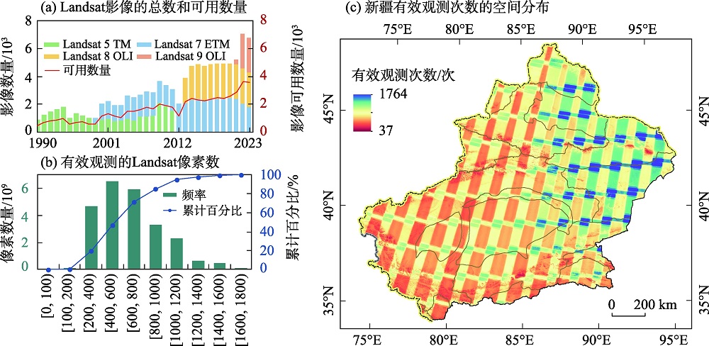
表1
本研究准确性评估的混淆矩阵"
| Sentinel-2A 目视解译结果 | 提取结果 | 总计/个 | 用户精度 | |
|---|---|---|---|---|
| 水体/个 | 非水体/个 | |||
| 水体 | 1098 | 47 | 1145 | 95.90% |
| 非水体 | 68 | 6787 | 6855 | 99.01% |
| 总计 | 1166 | 6834 | 8000 | 总体精度=98.57% |
| 生产者精度 | 94.17% | 99.31% | Kappa系数=94.18% | |
图3
1990—2023年新疆地区(a)水体频率空间分布、沿(b)经度、(c)纬度的地表水体总面积"

图4
1990—2023年新疆各流域的(a)永久性水体和(b)季节性水体的SD值和Cv值及在地表水体中所占比例"
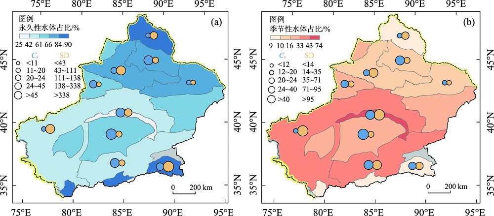

图5
流域及其山地、绿洲-荒漠地表水体面积变化趋势 注:柱状图中红色斜线表示不同区域水体面积变化趋势显著(P<0.05)。"
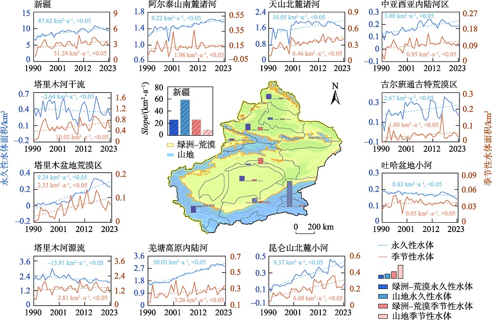
图6
各流域影响因素贡献率(%)"
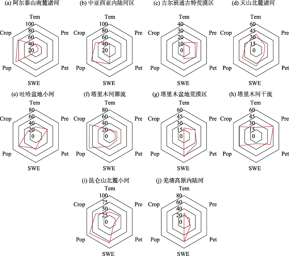
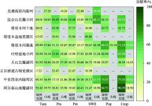
图7
各流域山地水体及绿洲-荒漠水体影响因素贡献率"


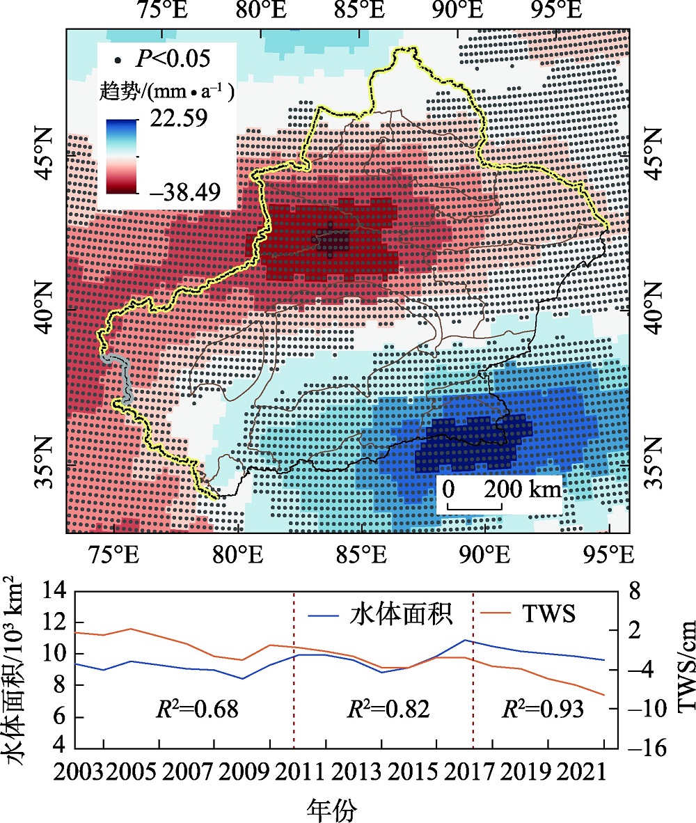
图8
新疆陆地水储量变化(TWS)趋势及与地表水体的对比 注:图中黑点表示陆地水储量变化趋势在统计上显著(P<0.05)。"
| [1] | Pekel J F, Cottam A, Gorelick N, et al. High-resolution mapping of global surface water and its long-term changes[J]. Nature, 2016, 540(7633): 418-422. |
| [2] |
Hall J W, Grey D, Garrick D, et al. Coping with the curse of freshwater variability[J]. Science, 2014, 346(6208): 429-430.
doi: 10.1126/science.1257890 pmid: 25342791 |
| [3] | Vörösmarty C J, McIntyre P B, Gessner M O, et al. Global threats to human water security and river biodiversity[J]. Nature, 2010, 467(7315): 555-561. |
| [4] |
姚俊强. 新疆空中水资源和地表水资源变化特征研究[J]. 干旱区研究, 2024, 41(2): 181-190.
doi: 10.13866/j.azr.2024.02.01 |
|
[Yao Junqiang. Change in atmospheric and surface water resource in Xinjiang[J]. Arid Zone Research, 2024, 41(2): 181-190. ]
doi: 10.13866/j.azr.2024.02.01 |
|
| [5] | Yao J, Chen Y, Guan X, et al. Recent climate and hydrological changes in a mountain-basin system in Xinjiang, China[J]. Earth-Science Reviews, 2022, 226: 103957. |
| [6] | Shen Y J, Shen Y, Guo Y, et al. Review of historical and projected future climatic and hydrological changes in mountainous semiarid Xinjiang (northwestern China), Central Asia[J]. CATENA, 2020, 187: 104343. |
| [7] | Lu H, Zhao R, Zhao L, et al. A contrarian growth: The spatiotemporal dynamics of open-surface water bodies on the northern slope of Kunlun Mountains[J]. Ecological Indicators, 2023, 157: 111249. |
| [8] | Zheng L, Xia Z, Xu J, et al. Exploring annual lake dynamics in Xinjiang (China): Spatiotemporal features and driving climate factors from 2000 to 2019[J]. Climatic Change, 2021, 166(3): 36. |
| [9] |
邹珊, 吉力力·阿不都外力, 黄文静, 等. 塔里木河下游生态输水对地表水体面积变化的影响[J]. 干旱区地理, 2021, 44(3): 681-690.
doi: 10.12118/j.issn.1000–6060.2021.03.10 |
|
[Zou Shan, Jilili Abuduwaili, Huang Wenjing, et al. Effects of ecological water conveyance on changes of surface water area in the lower reaches of Tarim River[J]. Arid Land Geography, 2021, 44(3): 681-690. ]
doi: 10.12118/j.issn.1000–6060.2021.03.10 |
|
| [10] | Alsdorf D E, Rodríguez E, Lettenmaier D P. Measuring surface water from space[J]. Reviews of Geophysics, 2007, 45(2): 1-24. |
| [11] | Liu X, Hu G, Chen Y, et al. High-resolution multi-temporal mapping of global urban land using Landsat images based on the Google Earth Engine Platform[J]. Remote Sensing of Environment, 2018, 209: 227-239. |
| [12] | Wang X, Xiao X, Zou Z, et al. Gainers and losers of surface and terrestrial water resources in China during 1989-2016[J]. Nature Communications, 2020, 11(1): 3471. |
| [13] | Huang C, Chen Y, Zhang S, et al. Detecting, extracting, and monitoring surface water from space using optical sensors: A review[J]. Reviews of Geophysics, 2018, 56(2): 333-360. |
| [14] | McFeeters S K. The use of the Normalized Difference Water Index (NDWI) in the delineation of open water features[J]. International Journal of Remote Sensing, 1996, 17(7): 1425-1432. |
| [15] | Xu H. Modification of normalised difference water index (NDWI) to enhance open water features in remotely sensed imagery[J]. International Journal of Remote Sensing, 2006, 27(14): 3025-3033. |
| [16] | Sun F, Sun W, Chen J, et al. Comparison and improvement of methods for identifying waterbodies in remotely sensed imagery[J]. International Journal of Remote Sensing, 2012, 33(21): 6854-6875. |
| [17] | Gómez C, White J C, Wulder M A. Optical remotely sensed time series data for land cover classification: A review[J]. ISPRS Journal of Photogrammetry and Remote Sensing, 2016, 116: 55-72. |
| [18] | Khatami R, Mountrakis G, Stehman S V. A meta-analysis of remote sensing research on supervised pixel-based land-cover image classification processes: General guidelines for practitioners and future research[J]. Remote Sensing of Environment, 2016, 177: 89-100. |
| [19] |
Chen Y, Li Z, Fan Y, et al. Progress and prospects of climate change impacts on hydrology in the arid region of Northwest China[J]. Environmental Research, 2015, 139: 11-19.
doi: 10.1016/j.envres.2014.12.029 pmid: 25682220 |
| [20] | Abatzoglou J T, Dobrowski S Z, Parks S A, et al. TerraClimate, a high-resolution global dataset of monthly climate and climatic water balance from 1958-2015[J]. Scientific Data, 2018, 5(1): 170191. |
| [21] |
Yang J, Huang X. The 30 m annual land cover dataset and its dynamics in China from 1990 to 2019[J]. Earth System Science Data, 2021, 13(8): 3907-3925.
doi: 10.5194/essd-13-3907-2021 |
| [22] |
Tapley B D, Bettadpur S, Ries J C, et al. GRACE measurements of mass variability in the earth system[J]. Science, 2004, 305(5683): 503-505.
doi: 10.1126/science.1099192 pmid: 15273390 |
| [23] | Zou Z, Xiao X, Dong J, et al. Divergent trends of open-surface water body area in the contiguous United States from 1984 to 2016[J]. Proceedings of the National Academy of Sciences, 2018, 115(15): 3810-3815. |
| [24] | Huang W, Duan W, Nover D, et al. An integrated assessment of surface water dynamics in the Irtysh River Basin during 1990-2019 and exploratory factor analyses[J]. Journal of Hydrology, 2021, 593: 125905. |
| [25] | Huang W, Duan W, Chen Y. Unravelling lake water storage change in Central Asia: Rapid decrease in tail-end lakes and increasing risks to water supply[J]. Journal of Hydrology, 2022, 614: 128546. |
| [26] | Zhou H, Liu S, Hu S, et al. Retrieving dynamics of the surface water extent in the upper reach of Yellow River[J]. Science of The Total Environment, 2021, 800: 149348. |
| [27] | Zou Z, Dong J, Menarguez M A, et al. Continued decrease of open surface water body area in Oklahoma during 1984-2015[J]. Science of The Total Environment, 2017, 595: 451-460. |
| [28] | Chen J, Kang T, Yang S, et al. Open-Surface water bodies dynamics analysis in the Tarim River Basin (North-Western China), based on Google Earth Engine cloud platform[J]. Water, 2020, 12(10): 2822. |
| [29] |
李崇巍, 王志慧, 汤秋鸿, 等. 1986—2019年黄河流域地表水体动态变化及其影响因素[J]. 地理学报, 2022, 77(5): 1153-1168.
doi: 10.11821/dlxb202205008 |
|
[Li Chongwei, Wang Zhihui, Tang Qiuhong, et al. Dynamics of surface water area in the Yellow River Basin and its influencing mechanism during 1986-2019 based on Google Earth Engine[J]. Acta Geographica Sinica, 2022, 77(5): 1153-1168. ]
doi: 10.11821/dlxb202205008 |
|
| [30] | Olofsson P, Foody G M, Herold M, et al. Good practices for estimating area and assessing accuracy of land change[J]. Remote Sensing of Environment, 2014, 148: 42-57. |
| [31] | Sen P K. Estimates of the regression coefficient based on Kendall’s Tau[J]. Journal of the American Statistical Association, 1968, 63(324): 1379-1389. |
| [32] | Hamed K H, Ramachandra Rao A. A modified Mann-Kendall trend test for autocorrelated data[J]. Journal of Hydrology, 1998, 204(1): 182-196. |
| [33] | Mann H B. Nonparametric Tests Against Trend[J]. Econometrica, 1945, 13(3): 245-259. |
| [34] |
王劲峰, 徐成东. 地理探测器: 原理与展望[J]. 地理学报, 2017, 72(1): 116-134.
doi: 10.11821/dlxb201701010 |
|
[Wang Jinfeng, Xu Chengdong. Geodetector: Principle and prospective[J]. Acta Geographica Sinica, 2017, 72(1): 116-134. ]
doi: 10.11821/dlxb201701010 |
|
| [35] |
李稚, 朱成刚, 汪家友, 等. 东昆仑库木库里盆地典型湖泊水量蒸发损失估算[J]. 干旱区地理, 2024, 47(8): 1263-1276.
doi: 10.12118/j.issn.1000-6060.2024.166 |
|
[Li Zhi, Zhu Chenggang, Wang Jiayou, et al. Estimation of evaporation loss from typical lakes in the Kumukuli Basin, East Kunlun Mountains[J]. Arid Land Geography, 2024, 47(8): 1263-1276. ]
doi: 10.12118/j.issn.1000-6060.2024.166 |
|
| [36] | Tao S, Zhang H, Feng Y, et al. Changes in China’s water resources in the early 21st century[J]. Frontiers in Ecology and the Environment, 2020, 18(4): 188-193. |
| [37] |
Yao F, Livneh B, Rajagopalan B, et al. Satellites reveal widespread decline in global lake water storage[J]. Science, 2023, 380(6646): 743-749.
doi: 10.1126/science.abo2812 pmid: 37200445 |
| [38] | Yao J, Chen Y, Zhao Y, et al. Climatic and associated atmospheric water cycle changes over the Xinjiang, China[J]. Journal of Hydrology, 2020, 585: 124823. |
| [39] |
Chen Y, Li B, Fan Y, et al. Hydrological and water cycle processes of inland river basins in the arid region of Northwest China[J]. Journal of Arid Land, 2019, 11(2): 161-179.
doi: 10.1007/s40333-019-0050-5 |
| [40] |
吝静, 赵成义, 马晓飞, 等. 基于生态系统服务价值的塔里木河干流土地利用结构优化[J]. 干旱区研究, 2021, 38(4): 1140-1151.
doi: 10.13866/j.azr.2021.04.26 |
|
[Lin Jing, Zhao Chengyi, Ma Xiaofei, et al. Optimization of land use structure based on ecosystem service value in the mainstream of Tarim river[J]. Arid Zone Research, 2021, 38(4): 1140-1151. ]
doi: 10.13866/j.azr.2021.04.26 |
|
| [41] | 陈亚宁, 陈亚鹏, 朱成刚, 等. 西北干旱荒漠区生态系统可持续管理理念与模式[J]. 生态学报, 2019, 39(20): 7410-7417. |
| [Chen Yaning, Chen Yapeng, Zhu Chenggang, et al. The concept and mode of ecosystem sustainable management in arid desert are as in Northwest China[J]. Acta Ecologica Sinica, 2019, 39(20): 7410-7417. ] | |
| [42] | Geng Q, Zhao Y, Sun S, et al. Spatio-temporal changes and its driving forces of irrigation water requirements for cotton in Xinjiang, China[J]. Agricultural Water Management, 2023, 280: 108218. |
| [43] | Chen P, Wang S, Liu Y, et al. Water availability in China’s oases decreased between 1987 and 2017[J]. Earth’s Future, 2023, 11(4): e2022EF003340. |
| [44] | Xia Q Q, Chen Y N, Zhang X Q, et al. Identifying reservoirs and estimating evaporation losses in a large arid inland basin in Northwestern China[J]. Remote Sensing, 2022, 14(5): 1105. |
| [45] |
陈永金, 艾克热木·阿布拉, 张天举, 等. 塔里木河下游生态输水对地下水埋深变化的影响[J]. 干旱区地理, 2021, 44(3): 651-658.
doi: 10.12118/j.issn.1000–6060.2021.03.07 |
|
[Chen Yongjin, Aikeremu Abula, Zhang Tianju, et al. Effects of ecological water conveyance on groundwater depth in the lower reaches of Tarim River[J]. Arid Land Geography, 2021, 44(3): 651-658. ]
doi: 10.12118/j.issn.1000–6060.2021.03.07 |
|
| [46] | Wu Q, Lane C R, Li X, et al. Integrating LiDAR data and multi-temporal aerial imagery to map wetland inundation dynamics using Google Earth Engine[J]. Remote Sensing of Environment, 2019, 228: 1-13. |
| [1] | 吕宁, 国语, 彭琴, 尹飞虎, 张嘉淇, 刘杏认, 曾梅, 许子函. 新疆耕地利用碳源/汇效应时空演变特征及其贡献因子[J]. 干旱区研究, 2025, 42(1): 179-190. |
| [2] | 孙琳琳, 刘琼, 黄观, 陈勇航, 魏鑫, 郭玉琳, 张太西, 高天一, 许赟红. 新疆和周边“一带一路”地区不同云天条件下地表太阳辐射[J]. 干旱区研究, 2024, 41(9): 1480-1490. |
| [3] | 吕壮壮, 乔庆庆, 董孙艺, 汪冬. 中中新世气候适宜期全球变暖背景下亚洲内陆干旱区古气候演化特征及驱动机制[J]. 干旱区研究, 2024, 41(8): 1309-1322. |
| [4] | 周杰, 王旭虎, 杜维波, 周晓雷, 杨洁, 张晓玮. 气候变化背景下的天山云杉潜在分布区预测[J]. 干旱区研究, 2024, 41(7): 1167-1176. |
| [5] | 菅政博, 罗浩, 单娜娜. “双碳”目标下新疆“三生”空间时空演变特征及碳效应[J]. 干旱区研究, 2024, 41(7): 1238-1248. |
| [6] | 柳华清, 王博, 贾妍妍, 解欣然, 张维. 新疆西天山峡谷不同坡位野核桃冻害特征[J]. 干旱区研究, 2024, 41(6): 1079-1088. |
| [7] | 马元植, 覃小林, 凌红波, 闫俊杰, 张广朋. 1991—2020年新疆中小湖泊面积变化时空特征及趋势分析[J]. 干旱区研究, 2024, 41(6): 905-916. |
| [8] | 梁双河, 牛最荣, 贾玲. 祖厉河干流近65 a径流变化及归因分析[J]. 干旱区研究, 2024, 41(6): 928-939. |
| [9] | 唐可欣, 郭建斌, 何亮, 陈林, 万龙. 中国旱区GPP时空演变特征及影响因素研究[J]. 干旱区研究, 2024, 41(6): 964-973. |
| [10] | 张皓哲, 薛亚永, 马圆圆, 薛国玄. 新疆绿洲生态系统固碳潜力研究[J]. 干旱区研究, 2024, 41(6): 998-1009. |
| [11] | 白事麟, 吕雅雅, 师小军. 不同生境和基质对经过牛消化道的新疆野苹果种子萌发和幼苗生长的影响[J]. 干旱区研究, 2024, 41(5): 821-829. |
| [12] | 许超杰, 窦燕, 孟琪琳. 基于EMD-GWO-LSTM模型的新疆标准化降水蒸散指数预测方法研究[J]. 干旱区研究, 2024, 41(4): 527-539. |
| [13] | 司琪, 樊浩然, 董文明, 刘新平. 新疆叶尔羌河流域景观生态风险评价及预测[J]. 干旱区研究, 2024, 41(4): 684-696. |
| [14] | 包佳玉, 李祥龙, 胡启文, 李涛. 新疆能源消费碳排放时空特征及能源结构调整路径探讨[J]. 干旱区研究, 2024, 41(3): 490-498. |
| [15] | 姚俊强. 新疆空中水资源和地表水资源变化特征研究[J]. 干旱区研究, 2024, 41(2): 181-190. |
|
||