Arid Zone Research ›› 2025, Vol. 42 ›› Issue (11): 2127-2141.doi: 10.13866/j.azr.2025.11.15
• Agricultural Ecology • Previous Articles Next Articles
ZHOU Jianwei1,2( ), ZHANG Zelin2,3, WU Hua1,2,3(), KONG Xiangyun2,3, CHEN Xingwang2,3
Received:2025-05-21
Revised:2025-09-19
Online:2025-11-15
Published:2025-12-13
Contact:
WU Hua
E-mail:gesang3650@163.com;xzwhua@163.com
ZHOU Jianwei, ZHANG Zelin, WU Hua, KONG Xiangyun, CHEN Xingwang. Spatiotemporal evolution and driving factors of cultivated land in the Hehuang Valley derived from topographic gradient data[J].Arid Zone Research, 2025, 42(11): 2127-2141.
Add to citation manager EndNote|Reference Manager|ProCite|BibTeX|RefWorks
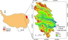
Fig. 1
Geographic location of Hehuang Valley"

Tab. 1
Grading criteria of topographic factors and area proportion in Hehuang Valley"
| 分级 | 海拔范围/m,占比/% | 坡度范围/(°),占比/% | 坡向类型,占比/% | 地貌类型,占比/% |
|---|---|---|---|---|
| Ⅰ | [1654,2205],5.72 | [0.00,2.00],3.33 | 平面,0.09 | 平原,9.26 |
| Ⅱ | (2205,2503],11.24 | (2.00,6.00],10.92 | 北,12.10 | 阶地,1.04 |
| Ⅲ | (2503,2772],15.09 | (6.00,15.00],26.98 | 东北,13.00 | 台地,2.66 |
| Ⅳ | (2772,3029],15.12 | (15.00,25.00],30.03 | 东,13.69 | 丘陵,3.87 |
| Ⅴ | (3029,3281],14.43 | (25.00,76.60],28.74 | 东南,12.34 | 小起伏山地,16.66 |
| Ⅵ | (3281,3535],14.07 | 南,11.85 | 中起伏山地,39.88 | |
| Ⅶ | (3535,3810],12.13 | 西南,12.55 | 大起伏山地,26.64 | |
| Ⅷ | (3810,4144],8.58 | 西,12.56 | ||
| Ⅸ | (4144,5213],3.64 | 西北,11.82 |
Tab. 2
Changes of land use types in the study area from 1980 to 2020 /km2"
| 土地利用类型 | 1980年 | 1990年 | 2000年 | 2010年 | 2020年 |
|---|---|---|---|---|---|
| 耕地 | 5128.97 | 5135.79 | 5138.56 | 5061.43 | 5009.74 |
| 林地 | 7117.62 | 7118.23 | 7130.29 | 7127.87 | 7110.34 |
| 草地 | 19562.31 | 19497.71 | 19440.46 | 19968.39 | 19939.73 |
| 水域 | 354.14 | 346.50 | 367.33 | 390.16 | 413.74 |
| 建设用地 | 465.58 | 475.24 | 496.97 | 559.61 | 623.55 |
| 未利用地 | 2632.48 | 2687.65 | 2687.50 | 2153.64 | 2164.02 |
| 合计 | 35261.11 | 35261.11 | 35261.11 | 35261.11 | 35261.11 |
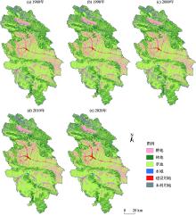
Fig. 2
Spatial distribution and change of land use types during the study period"

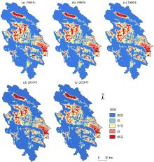
Fig. 3
Spatial changes in different kernel density grades of cultivated land in the study area"

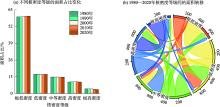
Fig. 4
Percentage and change of different cultivated land kernel density grades in Huanghe Valley (km2)"

Tab. 3
Transfer of cultivated land and other land use types in Hehuang Valley from 1980 to 2020 /km2"
| 时期 | 转移方式 | 林地 | 草地 | 水域 | 建设用地 | 未利用地 | 合计 |
|---|---|---|---|---|---|---|---|
| 1980—1990年 | 转出 | 0.01 | 0.12 | 0.09 | 6.59 | 0.00 | 6.81 |
| 转入 | 0.01 | 7.38 | 6.22 | 0.02 | 0.00 | 13.63 | |
| 1990—2000年 | 转出 | 0.04 | 0.22 | 11.55 | 20.65 | 0.88 | 33.34 |
| 转入 | 2.83 | 27.13 | 5.33 | 0.04 | 0.79 | 36.12 | |
| 2000—2010年 | 转出 | 4.94 | 120.33 | 19.03 | 60.67 | 0.27 | 205.24 |
| 转入 | 9.81 | 109.78 | 2.54 | 4.10 | 1.99 | 128.22 | |
| 2010—2020年 | 转出 | 8.89 | 58.24 | 7.14 | 65.71 | 0.49 | 140.47 |
| 转入 | 5.33 | 64.27 | 4.52 | 14.49 | 0.44 | 89.05 | |
| 1980—2020年 | 转出 | 12.44 | 162.40 | 34.92 | 151.07 | 1.55 | 362.38 |
| 转入 | 15.91 | 194.24 | 16.14 | 14.25 | 2.60 | 243.14 |
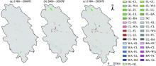
Fig. 5
Spatial distribution of cultivated land transfer in Hehuang Valley during the study period"

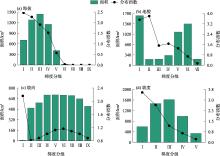
Fig. 6
Topographic gradient distribution of cultivated land in the study area"

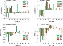
Fig. 7
Changes in the topographic gradient of cultivated land during the study period"

Tab. 4
Changes in standard deviation ellipse and center of gravity parameters of cultivated land"
| 年份 | 标准差椭圆 | 重心 | |||||
|---|---|---|---|---|---|---|---|
| 方位角/(°) | 长轴/km | 短轴/km | 扁率 | 经度 | 纬度 | ||
| 1980 | 148.662 | 86.361 | 46.291 | 1.866 | 102.028°E | 36.521°N | |
| 1990 | 148.733 | 86.409 | 46.382 | 1.863 | 102.028°E | 36.519°N | |
| 2000 | 148.691 | 86.417 | 46.514 | 1.858 | 102.028°E | 36.518°N | |
| 2010 | 147.638 | 86.959 | 45.911 | 1.894 | 102.023°E | 36.541°N | |
| 2020 | 147.771 | 87.367 | 45.998 | 1.899 | 102.024°E | 36.540°N | |
Fig. 8
Changes in standard deviation ellipse and center of gravity of cultivated land"
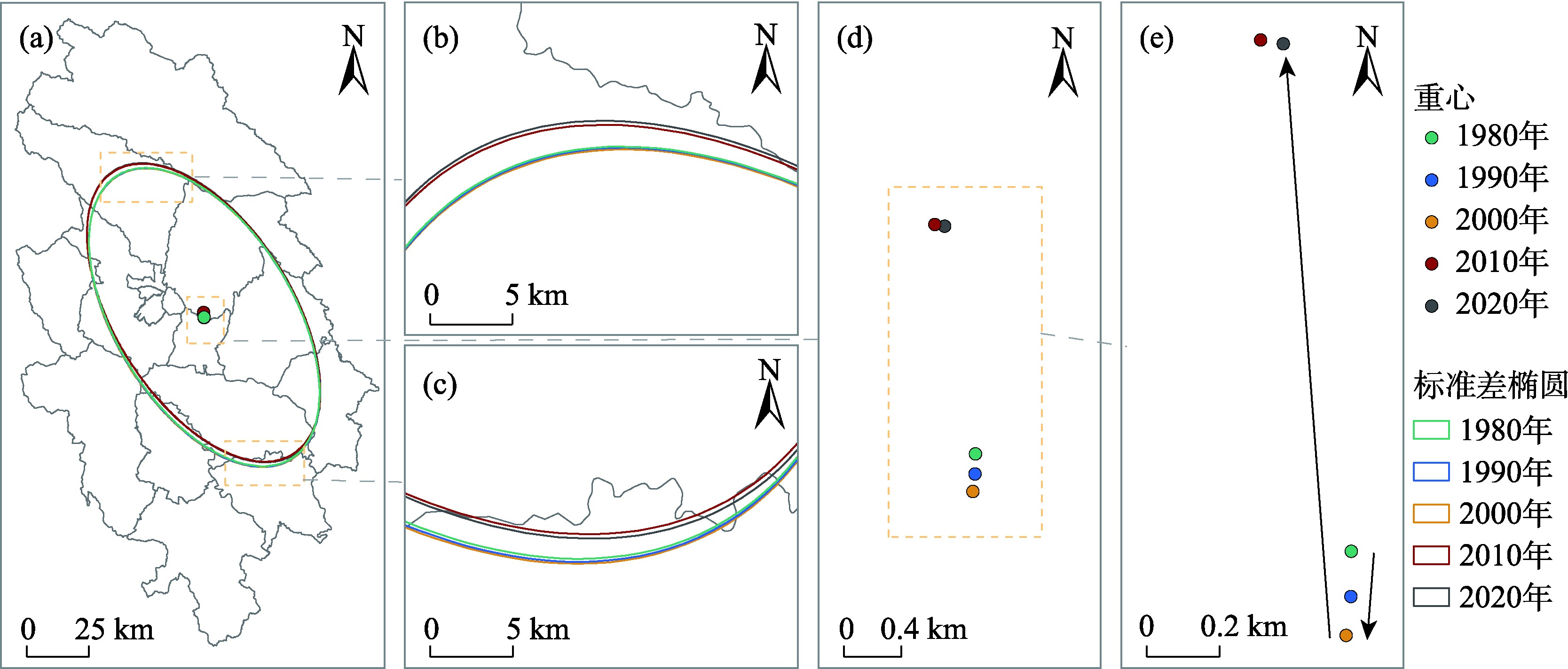
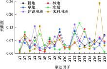
Fig. 9
Contribution of driving factors to changes in each land use type"

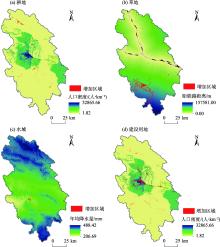
Fig. 10
Superposition of increased area of land use types and their dominant factor"

| [1] |
Ma L, Long H L, Tu S S, et al. Farmland transition in China and its policy implications[J]. Land Use Policy, 2020, 92: 104470.
doi: 10.1016/j.landusepol.2020.104470 |
| [2] |
Zhou Y, Li X H, Liu Y S. Cultivated land protection and rational use in China[J]. Land Use Policy, 2021, 106: 105454.
doi: 10.1016/j.landusepol.2021.105454 |
| [3] | 周建伟, 吴华, 赵鑫永, 等. 安宁河干旱河谷耕地地形梯度分异及其变化驱动因素[J]. 干旱地区农业研究, 2024, 42(4): 238-248. |
| [ Zhou Jianwei, Wu Hua, Zhao Xinyong, et al. Topographic gradient differentiation of cultivated land and driving factors of its change in the dry valley of Anning River[J]. Agricultural Research in the Arid Areas, 2024, 42(4): 238-248. ] | |
| [4] | 陈正发, 史东梅, 何伟, 等. 基于“要素-需求-调控”的云南坡耕地质量评价[J]. 农业工程学报, 2020, 36(12): 236-246. |
| [ Chen Zhengfang, Shi Dongmei, He Wei, et al. Quality evaluation of slope farmland in Yunnan Province based on “element-demand-regulation” framework[J]. Transactions of the Chinese Society of Agricultural Engineering, 2020, 36(12): 236-246. ] | |
| [5] | 陈睿山, 郭晓娜, 熊波, 等. 气候变化、土地退化和粮食安全问题: 关联机制与解决途径[J]. 生态学报, 2021, 41(7): 2918-2929. |
| [ Chen Ruishan, Guo Xiaona, Xiong Bo, et al. Climate change, land degradation, and food security: Linkages and potential solutions[J]. Acta Ecologica Sinica, 2021, 41(7): 2918-2929. ] | |
| [6] |
Liu J Y, Kuang W H, Zhang Z X, et al. Spatiotemporal characteristics, patterns, and causes of land-use changes in China since the late 1980s[J]. Journal of Geographical Sciences, 2014, 24(2): 195-210.
doi: 10.1007/s11442-014-1082-6 |
| [7] |
陈印军, 易小燕, 方琳娜, 等. 中国耕地资源与粮食增产潜力分析[J]. 中国农业科学, 2016, 49(6): 1117-1131.
doi: 10.3864/j.issn.0578-1752.2016.06.008 |
|
[ Chen Yinjun, Yi Xiaoyan, Fang Linna, et al. Analysis of cultivated land and grain production potential in China[J]. Scientia Agricultura Sinica, 2016, 49(6): 1117-1131. ]
doi: 10.3864/j.issn.0578-1752.2016.06.008 |
|
| [8] |
刘晶, 金晓斌, 徐伟义, 等. 1990—2020年中国耕地景观细碎化演变特征与趋势预判[J]. 地理学报, 2023, 78(9): 2163-2185.
doi: 10.11821/dlxb202309004 |
|
[ Liu Jing, Jin Xiaobin, Xu Weiyi, et al. Characteristic evolution and trend prediction of cultivated land landscape fragmentation in China from 1990 to 2020[J]. Acta Geographica Sinica, 2023, 78(9): 2163-2185. ]
doi: 10.11821/dlxb202309004 |
|
| [9] |
Long H L, Ge D Z, Zhang Y N, et al. Changing man-land interrelations in China’s farming area under urbanization and its implications for food security[J]. Journal of Environmental Management, 2018, 209: 440-451.
doi: 10.1016/j.jenvman.2017.12.047 |
| [10] | 万方, 邓清海, 刘莉, 等. 1990—2018年河湟谷地耕地的时空演变[J]. 水土保持通报, 2021, 41(3): 275-282. |
| [ Wan Fang, Deng Qinghai, Liu Li, et al. Spatiol and temporal evolution of cultivated land in the Hehuang Valley during 1990 to 2018[J]. Bulletin of Soil and Water Conservation, 2021, 41(3): 275-282. ] | |
| [11] | 李云路, 崔文刚, 陆清平, 等. 山区耕地破碎化时空演化分析——以贵州省为例[J]. 水土保持研究, 2022, 29(5): 301-309. |
| [ Li Yunlu, Cui Wengang, Lu Qingping, et al. Analysis on the spatiotemporal evolution of cultivated land fragmentation in mountainous areas—A case study of Guizhou Province[J]. Research of Soil and Water Conservation, 2022, 29(5): 301-309. ] | |
| [12] |
苏婉, 邱春霞, 赵镠. 西藏“一江两河”流域2000—2020年土地利用演变及多情景预测[J]. 测绘通报, 2024(6): 90-95.
doi: 10.13474/j.cnki.11-2246.2024.0616 |
|
[ Su Wan, Qiu Chunxia, Zhao Liu. Land use evolution and multi-scenario prediction of 2000-2020 “One River Two Rivers” basin in Xizang[J]. Bulletin of Surveying and Mapping, 2024(6): 90-95. ]
doi: 10.13474/j.cnki.11-2246.2024.0616 |
|
| [13] | 罗芳, 潘安, 陈忠升, 等. 四川省宜宾市1980—2018年耕地时空格局变化及其驱动因素[J]. 水土保持通报, 2021, 41(6): 336-344. |
| [ Luo Fang, Pan An, Chen Zhongsheng, et al. Spatiotemporal pattern change of cultivated land and its driving forces in Yibin City, Sichuan Province during 1980-2018[J]. Bulletin of Soil and Water Conservation, 2021, 41(6): 336-344. ] | |
| [14] | 金一诺, 王枫. 珠三角耕地利用转型的时空演化特征及其影响因素分析[J]. 水土保持研究, 2022, 29(4): 352-361. |
| [ Jin Yinuo, Wang Feng. Spatiotemporal evolution characteristics of cultivated land use transition and its influence factors in the Pearl River Delta[J]. Research of Soil and Water Conservation, 2022, 29(4): 352-361. ] | |
| [15] | 王千, 金晓斌, 周寅康, 等. 河北省耕地生态经济系统能值指标空间分布差异及其动因[J]. 生态学报, 2011, 31(1): 247-256. |
| [ Wang Qian, Jin Xiaobin, Zhou Yinkang, et al. Spatial differences and its driving factors of emergy indices on cultivated land eco-economic system in Hebei Province[J]. Acta Ecologica Sinica, 2011, 31(1): 247-256. ] | |
| [16] |
侯青青, 陈英, 裴婷婷, 等. 近25 a来甘肃省耕地资源时空变化及其影响因子[J]. 干旱区研究, 2022, 39(3): 955-967.
doi: 10.13866/j.azr.2022.03.29 |
|
[ Hou Qingqing, Chen Ying, Pei Tingting, et al. Analysis of cultivated land’s spatio-temporal changes and influencing factors in Gansu Province in recent 25 years[J]. Arid Zone Research, 2022, 39(3): 955-967. ]
doi: 10.13866/j.azr.2022.03.29 |
|
| [17] | 曹银贵, 袁春, 周伟, 等. 中国耕地变化的驱动因子及其省域差异分析[J]. 中国土地科学, 2008(2): 17-22. |
| [ Cao Yingui, Yuan Chun, Zhou Wei, et al. Analysis on driving forces and provincial differences of cultivated land change in China[J]. China Land Science, 2008(2): 17-22. ] | |
| [18] | 赵晓丽, 张增祥, 汪潇, 等. 中国近30 a耕地变化时空特征及其主要原因分析[J]. 农业工程学报, 2014, 30(3): 1-11. |
| [ Zhao Xiaoli, Zhang Zengxiang, Wang Xiao, et al. Analysis of Chinese cultivated land’s spatial-temporal changes and causes in recent 30 years[J]. Transactions of the Chinese Society of Agricultural Engineering, 2014, 30(3): 1-11. ] | |
| [19] |
Chen Q, Yang L E, Luo J, et al. The 300 years cropland changes reflecting climate impacts and social resilience at the Yellow River-Huangshui River Valley, China[J]. Environmental Research Letters, 2021, 16(6): 065006.
doi: 10.1088/1748-9326/abe82a |
| [20] |
罗静, 张镱锂, 刘峰贵, 等. 青藏高原东北部河湟谷地1726年耕地格局重建[J]. 地理研究, 2014, 33(7): 1285-1296.
doi: 10.11821/dlyj201407009 |
| [ Luo Jing, Zhang Yili, Liu Fenggui, et al. Reconstruction of cropland spatial patterns for 1726 on Yellow River-Huangshui River Valley in Northeast Qinghai-Xizang Plateau[J]. Geographical Research, 2014, 33(7): 1285-1296. ] | |
| [21] |
孙南沙, 陈琼, 刘峰贵, 等. 2000—2020年河湟谷地农业干旱研究[J]. 干旱区地理, 2023, 46(3): 437-447.
doi: 10.12118/j.issn.1000-6060.2022.367 |
|
[ Sun Nansha, Chen Qiong, Liu Fenggui, et al. Agricultural drought research in Yellow River-Huangshui River Valley from 2000 to 2020[J]. Arid Land Geography, 2023, 46(3): 437-447. ]
doi: 10.12118/j.issn.1000-6060.2022.367 |
|
| [22] |
郭蓉, 刘峰贵, 陈琼, 等. 北宋后期黄河上游地区耕地格局重建——以河湟谷地为例[J]. 自然资源学报, 2021, 36(1): 27-37.
doi: 10.31497/zrzyxb.20210102 |
|
[ Guo Rong, Liu Fenggui, Chen Qiong, et al. Reconstruction of cultivated land pattern in the upper reaches of the Yellow River in the late Northern Song Dynasty: Take Hehuang Valley as an example[J]. Journal of Natural Resources, 2021, 36(1): 27-37. ]
doi: 10.31497/zrzyxb.20210102 |
|
| [23] | 匡兵, 卢新海, 周敏. 中国城市土地经济密度的分布动态演进[J]. 中国土地科学, 2016, 30(10): 47-54. |
| [ Kuang Bin, Lu Xinhai, Zhou Min. Dynamic evolution of urban land economic density distribution in China[J]. China Land Science, 2016, 30(10): 47-54. ] | |
| [24] |
Qin Z L, Li W Y, Xiong X F. Estimating wind speed probability distribution using kernel density method[J]. Electric Power Systems Research, 2011, 81(12): 2139-2146.
doi: 10.1016/j.epsr.2011.08.009 |
| [25] |
张学斌, 罗君, 石培基, 等. 格网尺度下张掖生态系统服务价值时空演变及地形梯度分异特征[J]. 应用生态学报, 2020, 31(2): 543-553.
doi: 10.13287/j.1001-9332.202002.007 |
|
[ Zhang Xuebin, Luo Jun, Shi Peiji, et al. Spatial-temporal evolution pattern and terrain gradient differentiation of ecosystem service value in Zhangye, Northwest China at the grid scale[J]. Chinese Journal of Applied Ecology, 2020, 31(2): 543-553. ]
doi: 10.13287/j.1001-9332.202002.007 |
|
| [26] |
Zhou J W, Feng B, Wu H, et al. Spatio-temporal distribution characteristics and driving factors of forest land in the Da-Xiao Liangshan mountains based on topographic gradient[J]. Scientific Reports, 2025, 15: 7501.
doi: 10.1038/s41598-025-92129-y |
| [27] |
Qiu M L, Yuan C C, Yin G Y. Effect of terrain gradient on cadmium accumulation in soils[J]. Geoderma, 2020, 375: 114501.
doi: 10.1016/j.geoderma.2020.114501 |
| [28] | 陈利顶, 杨爽, 冯晓明. 土地利用变化的地形梯度特征与空间扩展——以北京市海淀区和延庆县为例[J]. 地理研究, 2008, 27(6): 1225-1234, 481. |
| [ Chen Liding, Yang Shuang, Feng Xiaoming. Topographic gradient characteristics and spatial expansion of land use change: A case study of Haidian District and Yanqing County in Beijing[J]. Geographical Research, 2008, 27(6): 1225-1234, 481. ] | |
| [29] | 郑准, 陈曦. 长江中游城市群城市创新潜力的分布动态与空间收敛性研究[J]. 长江流域资源与环境, 2024, 33(2): 271-284. |
| [ Zheng Zhun, Chen Xi. Study on the distribution dynamics and spatial convergence of urban innovation potential in the Yangtze River Middle Reaches Urban Agglomeration[J]. Resources and Environment in the Yangtze Basin, 2024, 33(2): 271-284. ] | |
| [30] |
Liang X, Guan Q F, Clarke K, et al. Understanding the drivers of sustainable land expansion using a patch-generating land use simulation (PLUS) model: A case study in Wuhan, China[J]. Computers, Environment and Urban Systems, 2021, 85: 101569.
doi: 10.1016/j.compenvurbsys.2020.101569 |
| [31] |
Yao Y, Liu X P, Li X, et al. Simulating urban land-use changes at a large scale by integrating dynamic land parcel subdivision and vector-based cellular automata[J]. International Journal of Geographical Information Science, 2017, 31(12): 2452-2479.
doi: 10.1080/13658816.2017.1360494 |
| [32] | 范昕. 黄河上游生态脆弱区土地利用/覆被变化及生态系统服务权衡与协同研究——以河湟谷地为例[D]. 武汉: 中国地质大学, 2022. |
| [ Fan Xin. Land use/Cover Change and the Tradeoff and Synergy of Ecosystem Services in Ecologically Fragile Regions of Upper Yellow River:A Case Study in Hehuang Valley[D]. Wuhan: China University of Geosciences, 2022. ] | |
| [33] | 林正雨, 何鹏, 李晓, 等. 基于耕地压力指数的四川省粮食安全状况研究[J]. 中国农业资源与区划, 2015, 36(7): 19-24. |
| [ Lin Zhengyu, He Peng, Li Xiao, et al. Food security of Sichuan Province based on cropland pressure index[J]. Chinese Journal of Agricultural Resources and Regional Planning, 2015, 36(7): 19-24. ] | |
| [34] |
张擂, 周煜明, 董杰谋, 等. 中国耕地非农化与非粮化时空分异及其治理策略[J]. 干旱区研究, 2025, 42(2): 372-383.
doi: 10.13866/j.azr.2025.02.16 |
|
[ Zhang Lei, Zhou Yuming, Dong Jiemou, et al. Spatiotemporal differentiation of nonagricultural and nongrain farmland in China and its management strategies[J]. Arid Zone Research, 2025, 42(2): 372-383. ]
doi: 10.13866/j.azr.2025.02.16 |
|
| [35] |
魏慧, 吕昌河, 尹旭. 青藏高原耕地的空间分异及其影响因素[J]. 地理科学, 2023, 43(3): 379-387.
doi: 10.13249/j.cnki.sgs.2023.03.001 |
| [ Wei Hui, Lyu Changhe, Yin Xu. Spatial differentiation of farmland and influencing factors on the Qinghai-Xizang Plateau[J]. Geographical Science, 2023, 43(3): 379-387. ] | |
| [36] | 方利, 姚敏, 于忠伟, 等. “三区三线”统筹划定中永久基本农田布局优化方法与实证[J]. 农业工程学报, 2022, 38(16): 42-50. |
| [ Fang Li, Yao Min, Yu Zhongwei, et al. Optimization method and empirical study on the layout of permanent basic farmland in the overall delimitation of “three land spaces and three control lines”[J]. Transactions of the Chinese Society of Agricultural Engineering, 2022, 38(16): 42-50. ] | |
| [37] |
易家林, 郭杰, 欧名豪, 等. 国土空间用途管制:制度变迁、目标导向与体系构建[J]. 自然资源学报, 2023, 38(6): 1415-1429.
doi: 10.31497/zrzyxb.20230603 |
|
[ Yi Jialin, Guo Jie, Ou Minghao, et al. Territorial space use regulation: Institutional change, goal orientation and system construction[J]. Journal of Natural Resources, 2023, 38(6): 1415-1429. ]
doi: 10.31497/zrzyxb.20230603 |
|
| [38] | 宦吉林, 王铁霖, 吴柏清. 岷江上游土地利用变化的地形梯度效应分析[J]. 人民长江, 2022, 53(7): 63-69. |
| [ Huan Jilin, Wang Tielin, Wu Baiqing. Terrain gradient effect analysis of land use change in upper reaches of Minjiang River[J]. Yangtze River, 2022, 53(7): 63-69. ] | |
| [39] | 周润芳, 孙建国, 张卓. 甘肃省榆中县地形对耕地分布影响[J]. 遥感信息, 2020, 35(4): 148-154. |
| [ Zhou Runfang, Sun Jianguo, Zhang Zhuo. Effeet of topography on cultivated land distribution in Yuzhong County of Gansu Province[J]. Remote Sensing Information, 2020, 35(4): 148-154. ] | |
| [40] |
Zhou J W, Feng B, Wu H, et al. Spatio-temporal evolution and topographic gradient effect of land use and ecosystem service value in the Lhasa River Basin[J]. Journal of Mountain Science, 2024, 21(6): 2059-2074.
doi: 10.1007/s11629-023-8570-z |
| [41] | 苟芳, 张立祯, 董宛麟, 等. 农牧交错带不同间套作模式的土地生产力[J]. 农业工程学报, 2013, 29(6): 129-141. |
| [ Gou Fang, Zhang Lizhen, Dong Wanlin, et al. Productivity of strip intercropping systems in agro-pastoral ecotone[J]. Transactions of the Chinese Society of Agricultural Engineering, 2013, 29(6): 129-141. ] | |
| [42] | 童菊儿, 严斌, 汪晖. 异地有偿补充耕地——土地发展权交易的浙江模式及政策启示[J]. 国际经济评论, 2012(2): 140-152, 8. |
| [ Tong Juer, Yan Bin, Wang Hui, et al. Land use right transfers— the Zhejiang model and its policy implications[J]. International Economic Review, 2012(2): 140-152, 8. ] |
| [1] | ZHANG Kun, WU Xinping, LIU Yongqiang, ZHANG Lifang, QIN Yan, YANG Yulu, GAN Hui. Spatiotemporal evolution and prediction of carbon storage in Xinjiang using the PLUS-InVEST model [J]. Arid Zone Research, 2025, 42(9): 1715-1725. |
| [2] | LIU Xiaoming, ZHENG Shiyan, QIAO Zhanming. Dynamic simulation of land use change and habitat quality in the Three River Source Region based on the PLUS-InVEST models [J]. Arid Zone Research, 2025, 42(6): 1080-1092. |
| [3] | DI Yanfeng, DUAN Weili, ZHOU Yiqi, HE Chao. Sustainable dynamics and driving factors of the global virtual water trade in crops [J]. Arid Zone Research, 2025, 42(6): 993-1003. |
| [4] | CHEN Zhen, CAI Zhaozhao, MA Nan, DAI Shuo, WANG Zhenlu. Spatial-temporal pattern and driving force analysis of NDVI in Xinjiang from 2001 to 2023 [J]. Arid Zone Research, 2025, 42(5): 922-932. |
| [5] | LIU Yue, GUO Qiang, YUAN Limin, DANG Xiaohong, MENG Zhongju, DONG Jing. Effects of three plant-based sand-fixing agents on water infiltration and evaporation in aeolian sandy soil [J]. Arid Zone Research, 2025, 42(4): 658-667. |
| [6] | ZHANG Lei, ZHOU Yuming, DONG Jiemou, LI Xiang, LIU Shidong, XU Liping. Spatiotemporal differentiation of nonagricultural and nongrain farmland in China and its management strategies [J]. Arid Zone Research, 2025, 42(2): 372-383. |
| [7] | HUANG Zhipu, WANG Junde, CHENG Yufei, ZHOU Haohao, ZHANG Zhan, BAO Zhiwei, YANG Chuanguo. Land use change and future habitat quality evaluation in the ecologically fragile areas of the middle and lower reaches of the Shule River [J]. Arid Zone Research, 2025, 42(11): 2104-2116. |
| [8] | LYU Ning, GUO Yu, PENG Qin, YIN Feihu, ZHANG Jiaqi, LIU Xingren, ZENG Mei, XU Zihan. Spatiotemporal evolution characteristics and contributing factors of the carbon effect in cultivated land use in Xinjiang [J]. Arid Zone Research, 2025, 42(1): 179-190. |
| [9] | ZHANG Wenrui, SUN Dongyuan, WANG Yike, YANG Jun, LAN Lijun, JIN Hujia, XU Yu. Coupling relationship and spatiao-temporal differentiation of the water resources-ecological environment-social economic system in the Hexi Corridor [J]. Arid Zone Research, 2024, 41(9): 1527-1537. |
| [10] | WU Siyuan, HAO Lina. Changes in vegetation cover and driving factors in the Yellow River Basin from 2001 to 2021 [J]. Arid Zone Research, 2024, 41(8): 1373-1384. |
| [11] | LI Bingjie, FAN Zhitao, QU Zhicheng, YAO Shunyu, SU Xiashu, LIU Dongwei, WANG Lixin. Evaluation and prediction of ecosystem carbon storage in the Inner Mongolia section of the Yellow River Basin based on the InVEST-PLUS model [J]. Arid Zone Research, 2024, 41(7): 1217-1227. |
| [12] | ZHANG Shunxin, WU Zihao, YAN Qingwu, LI Gui’e, MU Shouguo. Spatiotemporal changes in the ecosystem carbon storage on the northern slope of the Tianshan Mountains and simulations based on the PLUS-InVEST model [J]. Arid Zone Research, 2024, 41(7): 1228-1237. |
| [13] | ZHOU Jianwei, LUO Jun, MA Xueyang. Spatio-temporal evolution and driving factors of land use and ecosystem service value in the Lhasa River Basin, China [J]. Arid Zone Research, 2024, 41(6): 1021-1031. |
| [14] | LI Peiyao, WANG Xinjun, XU Shixian, GAO Shenghan, XUE Zhixuan, HENG Rui. Spatiotemporal pattern of NEP in Aksu River Basin based on PLUS land use simulation [J]. Arid Zone Research, 2024, 41(6): 1059-1068. |
| [15] | XU Mingjing, FENG Qiang, LYU Meng. Tradeoffs of ecosystem services and their influencing factors: A case study of the Shanxi Section of the Yellow River Basin [J]. Arid Zone Research, 2024, 41(3): 467-479. |
|
||