Arid Zone Research ›› 2025, Vol. 42 ›› Issue (10): 1777-1790.doi: 10.13866/j.azr.2025.10.03
• Weather and Climate • Previous Articles Next Articles
YU Zhixiang1( ), YANG Xia2(), YU Xiaojing3, JIANG Xutao3
Received:2025-04-09
Revised:2025-06-25
Online:2025-10-15
Published:2025-10-22
Contact:
YANG Xia
E-mail:yzxwxz@126.com;yangxia921@163.com
YU Zhixiang, YANG Xia, YU Xiaojing, JIANG Xutao. Capability and biases of satellite precipitation products in monitoring extreme rainstorms along the northern slope of the Kunlun Mountains[J].Arid Zone Research, 2025, 42(10): 1777-1790.
Add to citation manager EndNote|Reference Manager|ProCite|BibTeX|RefWorks
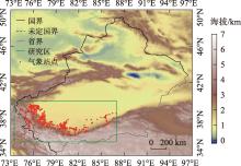
Fig. 1
Distribution of topographic height and meteorological observation stations"

Tab. 1
Information of eight satellite precipitation products"
| 卫星降水产品 | 时间分辨率 | 空间分辨率 | 数据来源 | 关键信息 |
|---|---|---|---|---|
| GPM IMERG Early | 30 min | 0.1° | NASA( | Early采用云移动矢量传播算法中的前向传播算法,Late增加了后向传播算法,Final进行了地面雨量数据校准 |
| GPM IMERG Final | 30 min | 0.1° | ||
| GPM IMERG Late | 30 min | 0.1° | ||
| GSMaP_NOW | 30 min | 0.1° | JAXA( | 基于低轨卫星的微波数据和地球静止卫星的红外数据开发 |
| GSMaP_NRT | 1 h | 0.1° | ||
| GSMaP_MVK | 1 h | 0.1° | ||
| FY2H | 1 h | 10 km | NSMC( | 采用卫星AGRI红外通道资料实时估计地面降水强度,未进行地面雨量计订正 |
| FY4A | 5 min | 4 km | NSMC( |
Tab. 2
Summary of statistical evaluation methods used in this study"
| 统计指标 | 公式 | 最优值 | 物理意义 |
|---|---|---|---|
| 相关系数CC | 1 | 衡量卫星与观测降水量之间的线性关系强度和方向 | |
| 平均绝对误差MAE | 0 | 表示卫星与观测降水量之间的差距大小 | |
| 均方根误差RMSE | 0 | 衡量卫星与观测降水量之间的偏差程度 | |
| 标准偏差比SDV | 1 | 表示卫星与观测降水量的变化幅度 | |
| 相对误差Bias | 0 | 表示卫星与观测降水量之间的系统性偏差 | |
| 命中率POD | 1 | NA为站点显示有雨,卫星数据也显示有雨;NB为站点显示无雨,卫星数据显示有雨;NC为站点显示有雨,卫星数据显示无雨;ND为站点显示无雨,卫星数据也显示无雨 | |
| 误报率FAR | 0 | ||
| TS评分 | 1 | ||
| 准确率AC | 1 |
Tab. 3
Overview of three extreme rainstorms along the northern slope of the Kunlun Mountains"
| 过程 | 起止时间 | 总降水 站数/个 | 暴雨 站数/个 | 暴雨中心站点 | 暴雨中心 累积降水量 /mm | 最大1 h 降水量 /mm | 最大1 h 降水量出 现时次 |
|---|---|---|---|---|---|---|---|
| 1 | 2019年6月24日 20:00—25日20:00 | 286 | 29 | 和田地区策勒县奴尔乡努尔河战斗渠渠首站 | 61.3 | 23.5 | 25日9:00 |
| 2 | 2020年5月5日 20:00—6日20:00 | 270 | 11 | 巴州且末县奥依拉克镇莫勒切河水库 | 39.7 | 19.9 | 6日20:00 |
| 3 | 2021年6月15日 20:00—16日20:00 | 336 | 152 | 和田地区洛浦县山普鲁乡泥石流频发区1号站 | 106.6 | 28.8 | 15日21:00 |

Fig. 2
Cumulative precipitation distribution for three extreme rainstorms"


Fig. 3
Comparison of maximum hourly precipitation during three extreme rainstorms"


Fig. 4
Temporal evolution of cumulative precipitation during three extreme rainstorms"

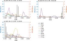
Fig. 5
Temporal evolution of precipitation centers during three extreme rainstorms"

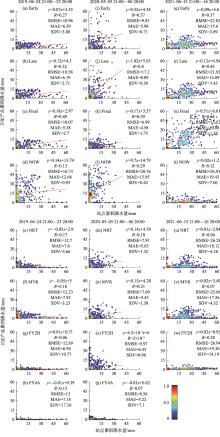
Fig. 6
Correlation of station-measured precipitation and satellite product interpolation for three extreme rainstorms"

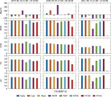
Fig. 7
Comprehensive scoring of eight satellite precipitation products for three extreme rainstorms"

Tab. 4
Statistical summary of the comparison among eight products in torrential rainfall events"
| 遥感降水产品 | 相关系数 | 平均误差/mm | 均方根误差/mm | 相对偏差/% | 命中率 | 误报率 | 关键成功指数 |
|---|---|---|---|---|---|---|---|
| Early | 0.24 | -15.32 | 25.10 | -60.42 | 0.16 | 0.44 | 0.14 |
| Final | 0.39 | -7.17 | 18.02 | -28.22 | 0.54 | 0.18 | 0.48 |
| Late | 0.22 | -9.85 | 26.22 | -41.61 | 0.27 | 0.45 | 0.22 |
| MVK | 0.41 | -20.17 | 27.68 | -77.51 | 0.10 | 0.47 | 0.09 |
| NOW | 0.46 | -0.76 | 27.67 | -4.49 | 0.25 | 0.76 | 0.14 |
| NRT | 0.39 | -21.09 | 28.55 | -81.12 | 0.08 | 0.52 | 0.07 |
| FY2H | 0.48 | -20.25 | 28.91 | -82.23 | 0.02 | 0.87 | 0.02 |
| FY4A | 0.11 | -27.76 | 31.71 | -99.69 | 0.00 | - | 0.00 |
Tab. 5
Relative bias ratio for the error components of eight products in torrential rainfall events"
| 遥感降水产品 | 相对偏差/% | 偏差相对贡献率/% | ||
|---|---|---|---|---|
| 命中 | 漏报 | 误报 | ||
| Early | -60.42 | -1.19 | -66.06 | 6.83 |
| Final | -28.22 | -10.69 | -24.65 | 7.12 |
| Late | -41.61 | -0.16 | -56.55 | 15.10 |
| MVK | -77.51 | -3.70 | -77.29 | 3.48 |
| NOW | -4.49 | 10.72 | -71.43 | 56.22 |
| NRT | -81.12 | -1.82 | -83.31 | 4.01 |
| FY2H | -82.23 | 0.10 | -90.75 | 8.42 |
| FY4A | -99.69 | 0.00 | -99.69 | 0.00 |
| [1] | 丁一汇. 暴雨和中尺度气象学问题[J]. 气象学报, 1994, 52(3): 274-284. |
| [Ding Yihui. Some aspects of rainstorm and meso-csale meteorology[J]. Acta Meteorologica Sinica, 1994, 52(3): 274-284. ] | |
| [2] | 刘松楠, 汪君, 王会军. 高分辨率卫星对“21·7”河南特大暴雨监测能力分析[J]. 气象学报, 2022, 80(5): 765-776. |
| [Liu Songnan, Wang Jun, Wang Huijun. Analysis of the monitoring ability of high-resolution satellites for the “21·7” heavy rain in Henan[J]. Acta Meteorologica Sinica, 2022, 80(5): 765-776. ] | |
| [3] |
李晓萌, 杨莲梅, 李建刚, 等. 昆仑山北坡“6·14”极端暴雨过程的中尺度对流系统特征分析[J]. 干旱区地理, 2024, 47(10): 1700-1712.
doi: 10.12118/j.issn.1000-6060.2023.416 |
|
[Li Xiaomeng, Yang Lianmei, Li Jiangang, et al. Mesoscale convective systems characteristic analysis of the “6·14” extreme rainstorm in northern slope of the Kunlun Mountains[J]. Arid Land Geography, 2024, 47(10): 1700-1712. ]
doi: 10.12118/j.issn.1000-6060.2023.416 |
|
| [4] |
杨霞, 杨柳. 昆仑山北坡西段和中段暴雨的特征及差异[J]. 干旱区研究, 2025, 42(2): 202-211.
doi: 10.13866/j.azr.2025.02.02 |
|
[Yang Xia, Yang Liu. Characteristics and differences in heavy rainfall in the western and central sections of the northern slope of the Kunlun Mountains[J]. Arid Zone Research, 2025, 42(2): 202-211. ]
doi: 10.13866/j.azr.2025.02.02 |
|
| [5] |
徐柳昕, 王文雨, 王晓燕, 等. 多源降水产品在高寒内陆河流域的适用性和误差组分[J]. 干旱区研究, 2025, 42(1): 51-62.
doi: 10.13866/j.azr.2025.01.05 |
|
[Xu Liuxin, Wang Wenyu, Wang Xiaoyan, et al. Evaluation and error decomposition of multisource precipitation data in an alpine and endorheic river watershed[J]. Arid Zone Research, 2025, 42(1): 51-62. ]
doi: 10.13866/j.azr.2025.01.05 |
|
| [6] | 庞琛锟. 多种卫星降水产品对中国大陆极端降水的监测能力评估[D]. 郑州: 河南大学, 2023. |
| [Pang Chenkun. Evaluation of Monitoring Capability of Various Satellite Precipitation Products for Extreme Precipitation in the Mainland of China[D]. Zhengzhou: Hennan University, 2023. ] | |
| [7] | 刘若兰, 江善虎, 任立良, 等. 全球降水观测计划IMERG降水产品对中国大陆极端降雨监测能力评估[J]. 中国农村水利水电, 2021(4): 57-63. |
| [Liu Ruolan, Jiang Shanhu, Ren Liliang, et al. Evaluation of GPM IMERG precipitation product in capturing extreme precipitation events over China’s mainland[J]. China Rural Water and Hydropower, 2021(4): 57-63. ] | |
| [8] | 卢美圻. GPM/DPR星载双频雷达探测降水的敏感性与差异性分析[D]. 南京: 南京信息工程大学, 2017. |
| [Lu Meiqi. Analysis of the Sensitivity and Difference Based on GPM/DPR Spaceborne Dual Frequency Radar for Detecting Precipitation[D]. Nanjing: Nanjing University of Information Science & Technology, 2017. ] | |
| [9] |
高玥, 徐慧, 刘国. GSMaP遥感降水产品对典型极端降水事件监测能力评估[J]. 遥感技术与应用, 2019, 34(5): 1121-1132.
doi: 10.11873/j.issn.1004-0323.2019.5.1121 |
| [Gao Yue, Xu Hui, Liu Guo. Evaluation of the GSMaP estimates on monitoring extreme precipitation events[J]. Remote Sensing Technology and Application, 2019, 34(5): 1121-1132. ] | |
| [10] | 谷松岩, 张鹏, 陈林, 等. 中国首颗降水测量卫星(风云三号G星)的探测能力概述与展望[J]. 暴雨灾害, 2023, 42(5): 489-498. |
| [Gu Songyan, Zhang Peng, Chen Lin, et al. Overview and prospect of the detection capability of China’s first precipitation measurement satellite FY-3G[J]. Torrential Rain and Disasters, 2023, 42(5): 489-498. ] | |
| [11] |
李晨蕊, 伏晶, 刘维成, 等. 应用FY卫星产品分析陇东半干旱区特大暴雨事件云特征[J]. 干旱气象, 2022, 40(6): 954-967.
doi: 10.11755/j.issn.1006-7639(2022)-06-0954 |
| [Li Chenrui, Fu Jing, Liu Weicheng, et al. Cloud characteristics analysis of a torrential rainfall event use FY satellite in semi-arid region of eastern Gansu Province[J]. Journal of Arid Meteorology, 2022, 40(6): 954-967. ] | |
| [12] | Kummerow C J, Simpson O, Thiele W, et al. The status of the Tropical Rainfall Measuring Mission (TRMM) after two years in orbit[J]. Journal of Atmospheric and Oceanic Technology, 1998, 39: 1965-1982. |
| [13] | 傅云飞, 罗晶, 罗双, 等. GPM卫星DPR和GMI探测的2018年5月重庆超级单体云团降水结构特征分析[J]. 暴雨灾害, 2022, 41(1): 1-14. |
| [Fu Yunfei, Luo Jing, Luo Shuang, et al. Rainstorm structure of a supercell cloud occurred in Chongqing in May 2018 measured by GPM DPR and GMI[J]. Torrential Rain and Disasters, 2022, 41(1): 1-14. ] | |
| [14] | 张中波, 马红, 范泽. FY2卫星反演云特征参数与湖南省降水的相关性[J]. 中南农业科技, 2024, 45(8): 121-125. |
| [Zhang Zhongbo, Ma Hong, Fan Ze. The correlation between FY2 satellite-retrieved cloud characteristic parameters and precipitation in Hunan Province[J]. South-Central Agricultural Science and Technology, 2024, 45(8): 121-125. ] | |
| [15] | 常倬林, 党张利, 孙艳桥, 等. 基于FY2G卫星的宁夏空中云水资源特征研究[J]. 气象研究与应用, 2022, 43(1): 47-52. |
| [Chang Zhuolin, Dang Zhangli, Sun Yanqiao, et al. Study on characteristics of air cloud water resources in Ningxia based on FY2G satellite[J]. Journal of Meteorological Research and Application, 2022, 43(1): 47-52. ] | |
| [16] | 王一丞, 刘维成, 宋兴宇, 等. 卫星降水产品在陇东2022年7月特大暴雨事件中的适用性评估[J]. 干旱气象, 2023, 41(6): 997-1007. |
| [Wang Yicheng, Liu Weicheng, Song Xingyu, et al. Applicability evaluation of satellite-derived precipitation products in the torrential heavy rainfall event in East Gansu in July 2022[J]. Journal of Arid Meteorology, 2023, 41(6): 997-1007. ] | |
| [17] | 孙乐强, 郝振纯, 王加虎, 等. TMPA卫星降水数据的评估与校正[J]. 水利学报, 2014, 46(10): 1135-1146. |
| [Sun Leqiang, Hao Zhenchun, Wang Jiahu, et al. Assessment and correction of TMPA products 3B42RT and 3B42V6[J]. Shuili Xuebao, 2014, 46(10): 1135-1146. ] | |
| [18] |
Chen F, Crow W T, Ciabatta L, et al. Enhanced large-scale validation of satellite-based land rainfall products[J]. Journal of Hydrometeorology, 2021, 22(2): 245-257.
doi: 10.1175/JHM-D-20-0056.1 |
| [19] | Sun Q, Miao C, Duan Q, et al. A review of global precipitation data sets: Data sources, estimation, and intercomparisons[J]. Reviews of Geophysics, 2018, 56(1): 79-107. |
| [20] | Hou A Y, Kakar R K, Neeck S, et al. The global precipitation measurement mission[J]. Bulletin of the American Meteorological Society, 2013, 95(5): 701-722. |
| [21] | 张奡祺, 傅云飞. GPM卫星双频测雨雷达探测降水结构的个例特征分析[J]. 大气科学, 2018, 42(1): 33-51. |
| [Zhang Aoqi, Fu Yunfei. The structural characteristics of precipitation cases detected by dual-frequency radar of GPM satellite[J]. Chinese Journal of Atmospheric Sciences, 2018, 42(1): 33-51. ] | |
| [22] | 陈汉清, 鹿德凯, 周泽慧, 等. GPM降水产品评估研究综述[J]. 水资源保护, 2019, 35(1): 27-34. |
| [Chen Hanqing, Lu Dekai, Zhou Zehui, et al. An overview of assessments on global precipitation measurement (GPM) precipitation products[J]. Water Resources Protection, 2019, 35(1): 27-34. ] | |
| [23] | 肖开提·多莱特. 新疆降水量级标准的划分[J]. 沙漠与绿洲气象, 2005, 28(3): 7-8. |
| [Xiaokaiti Duolaite. Formulation of precipitation intensity standard of Xinjiang[J]. Desert and Oasis Meteorology, 2005, 28(3): 7-8. ] | |
| [24] | 杨霞, 周鸿奎, 赵逸舟, 等. 新疆夏季暴雨精细化特征分析[J]. 气象, 2021, 47(12): 1501-1511. |
| [Yang Xia, Zhou Hongkui, Zhao Yizhou, et al. Analysis on fine-scale characteristics of summer rainstorm in Xinjiang[J]. Meteorological Monthly, 2021, 47(12): 1501-1511. ] | |
| [25] |
李伶杰, 胡庆芳, 黄勇, 等. 近实时卫星降水数据对南京“20170610”极端性强降水过程的监测分析[J]. 高原气象, 2018, 37(3): 806-814.
doi: 10.7522/j.issn.1000-0534.2017.00080 |
|
[Li Lingjie, Hu Qingfang, Huang Yong, et al. Monitoring and analysis of the extreme heavy rainfall process on June 10, 2017 in Nanjing using five near real time satellite rainfall estimations[J]. Plateau Meteorology, 2018, 37(3): 806-814. ]
doi: 10.7522/j.issn.1000-0534.2017.00080 |
|
| [26] | 胡庆芳, 张野, 李伶杰, 等. GPM近实时反演数据对河南省2021年“7·20”极端暴雨的比较分析[J]. 水科学进展, 2022, 33(4): 567-580. |
| [Hu Qingfang, Zhang Ye, Li Lingjie, et al. Comparative evaluation of GPM near-real-time precipitation products during the 20 July 2021 extreme rainfall event in Henan Province[J]. Advances in Water Science, 2022, 33(4): 567-580. ] |
|
||