Arid Zone Research ›› 2024, Vol. 41 ›› Issue (6): 1021-1031.doi: 10.13866/j.azr.2024.06.11
• Ecology and Environment • Previous Articles Next Articles
ZHOU Jianwei1,2,3,4( ), LUO Jun2,3,4(), MA Xueyang5
Received:2022-11-23
Revised:2024-02-09
Online:2024-06-15
Published:2024-07-03
ZHOU Jianwei, LUO Jun, MA Xueyang. Spatio-temporal evolution and driving factors of land use and ecosystem service value in the Lhasa River Basin, China[J].Arid Zone Research, 2024, 41(6): 1021-1031.
Add to citation manager EndNote|Reference Manager|ProCite|BibTeX|RefWorks
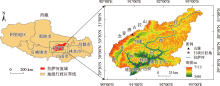
Fig. 1
Location of the Lhasa River Basin"

Tab. 1
"
| 生态系统服务类型 | 土地利用类型 | |||||
|---|---|---|---|---|---|---|
| 耕地 | 林地 | 草地 | 水域 | 建设用地 | 未利用地 | |
| 食物生产 | 2920.16 | 927.58 | 790.16 | 2748.38 | 34.35 | 34.35 |
| 原料生产 | 1374.19 | 2164.35 | 1168.06 | 790.16 | 0.00 | 103.06 |
| 水资源供给 | 68.71 | 1133.71 | 652.74 | 28480.13 | 0.00 | 68.71 |
| 气体调节 | 2301.77 | 7111.44 | 4156.93 | 2645.32 | 0.00 | 171.77 |
| 气候调节 | 1236.77 | 21299.98 | 10959.18 | 7867.25 | 0.00 | 343.55 |
| 净化环境 | 343.55 | 6183.86 | 3607.25 | 19066.91 | 0.00 | 515.32 |
| 水文调节 | 927.58 | 13260.95 | 8039.02 | 351243.48 | 0.00 | 343.55 |
| 土壤保持 | 3538.54 | 8657.41 | 5050.16 | 3195.00 | 68.71 | 446.61 |
| 维持养分循环 | 412.26 | 652.74 | 377.90 | 240.48 | 0.00 | 34.35 |
| 生物多样性 | 446.61 | 7901.60 | 4603.54 | 8760.47 | 1168.06 | 412.26 |
| 美学景观 | 206.13 | 3469.83 | 2026.93 | 6493.06 | 34.35 | 171.77 |
| 合计 | 13776.27 | 72763.47 | 41431.89 | 431530.64 | 1305.48 | 2645.32 |
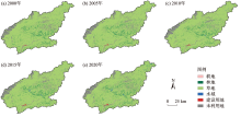
Fig. 2
Spatial distribution of land use types in Lhasa River Basin"

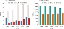
Fig. 3
Area changes of land use types in Lhasa River Basin from 2000 to 2020"

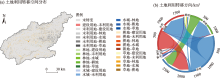
Fig. 4
Land use transformation spatial distribution and direction in the study area from 2000 to 2020"

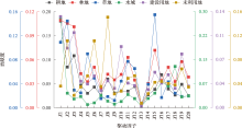
Fig. 5
Contribution of driving factors of land use change in Lhasa River Basin from 2000 to 2020"

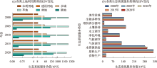
Fig. 6
Changes of ESV in Lhasa River Basin from 2000 to 2020"

Tab. 2
Changes of area proportion of ESV at different levels in the study area /%"
| ESV等级 | |||||
|---|---|---|---|---|---|
| 极低价值 | 低价值 | 中等低价值 | 高价值 | 极高价值 | |
| 2000年 | 3.87 | 13.34 | 64.35 | 17.74 | 0.69 |
| 2005年 | 3.57 | 13.47 | 65.01 | 17.28 | 0.66 |
| 2010年 | 3.35 | 12.73 | 64.37 | 18.58 | 0.96 |
| 2015年 | 3.73 | 14.24 | 63.39 | 17.44 | 1.20 |
| 2020年 | 4.33 | 14.75 | 59.42 | 20.00 | 1.50 |
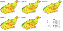
Fig. 7
Spatial distribution of ESV in Lhasa River Basin"


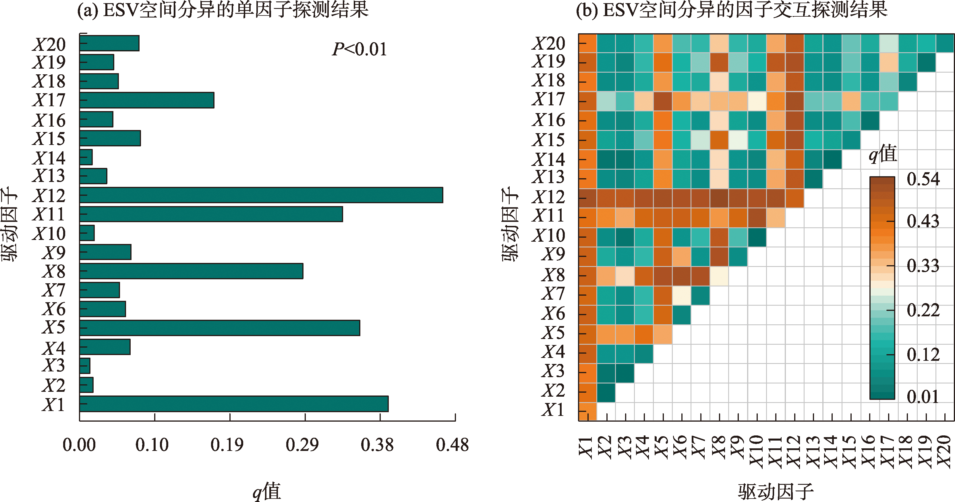
Fig. 8
Result of driving factors of spatial differentiation of ESV in Lhasa River Basin"
| [1] | Costanza R, Darge R, Groot R D, et al. The value of the world’s ecosystem services and natural capital[J]. Nature, 1997, 387(6630): 253-260. |
| [2] | 谢高地, 张彩霞, 张昌顺, 等. 中国生态系统服务的价值[J]. 资源科学, 2015, 37(9): 1740-1746. |
| [Xie Gaodi, Zhang Caixia, Zhang Changshun, et al. The value of ecosystem services in China[J]. Resources Science, 2015, 37(9): 1740-1746. ] | |
| [3] | 兰紫橙, 贾岚, 程煜. 闽江流域生态系统服务价值评估及权衡协同关系[J]. 生态学报, 2020, 40(12): 3909-3920. |
| [Lan Zicheng, Jia Lan, Cheng Yu. The ecosystem services evaluation and trade-off synergy in Min River Basin[J]. Acta Ecologica Sinica, 2020, 40(12): 3909-3920. ] | |
| [4] | 严恩萍, 林辉, 王广兴, 等. 1990—2011年三峡库区生态系统服务价值演变及驱动力[J]. 生态学报, 2014, 34(20): 5962-5973. |
| [Yan Enping, Lin Hui, Wang Guangxing, et al. Analysis of evolution and driving force of ecosystem service values in the Three Gorges Reservoir region during 1990-2011[J]. Acta Ecologica Sinica, 2014, 34(20): 5962-5973. ] | |
| [5] |
黄木易, 岳文泽, 方斌, 等. 1970—2015年大别山区生态服务价值尺度响应特征及地理探测机制[J]. 地理学报, 2019, 74(9): 1904-1920.
doi: 10.11821/dlxb201909015 |
|
[Huang Muyi, Yue Wenze, Fang Bin, et al. Scale response characteristics and geographic exploration mechanism of spatial differentiation of ecosystem service values in Dabie Mountain area, central China from 1970 to 2015[J]. Acta Geographica Sinica, 2019, 74(9): 1904-1920. ]
doi: 10.11821/dlxb201909015 |
|
| [6] | 雷金睿, 陈宗铸, 陈小花, 等. 1980—2018年海南岛土地利用与生态系统服务价值时空变化[J]. 生态学报, 2020, 40(14): 4760-4773. |
| [Lei Jinrui, Chen Zongzhu, Chen Xiaohua, et al. Spatio-temporal changes of land use and ecosystem services value in Hainan Island from 1980 to 2018[J]. Acta Ecologica Sinica, 2020, 40(14): 4760-4773. ] | |
| [7] |
邓楚雄, 钟小龙, 谢炳庚, 等. 洞庭湖区土地生态系统的服务价值时空变化[J]. 地理研究, 2019, 38(4): 844-855.
doi: 10.11821/dlyj020170999 |
|
[Deng Chuxiong, Zhong Xiaolong, Xie Binggeng, et al. Spatial and temporal changes of land ecosystem service value in Dongting Lake area in 1995-2015[J]. Geographical Research, 2019, 38(4): 844-855. ]
doi: 10.11821/dlyj020170999 |
|
| [8] | 周建伟, 杨海青, 邓青春, 等. 干旱河谷区土地利用与生态系统服务价值时空演变——以四川攀西地区为例[J]. 环境工程技术学报, 2023, 13(2): 715-724. |
| [Zhou Jianwei, Yang Haiqing, De-ng Qingchun, et al. Spatial-temporal changes of land use and ecosystem service value in dry valleys: A case study of Panxi area, Sichuan Province[J]. Journal of Environmental Engineering Techn-ology, 2023, 13(2): 715-724. ] | |
| [9] | 张晓敏, 张东梅, 张伟. 人类活动对额尔齐斯河流域碳储量的影响[J]. 干旱区研究, 2023, 40(8): 1333-1345. |
| [Zhang Xiaomin, Zhang Dongmei, Zhang Wei. Effects of human activities on carbon storage in the Irtysh River Basin[J]. Arid Zone Research, 2023, 40(8): 1333-1345. ] | |
| [10] | 周建伟, 罗君. 安宁河流域土地利用地形梯度分异及其转型驱动因素[J]. 西南农业学报, 2023, 36(6): 1318-1327. |
| [Zhou Jianwei, Luo Jun. Terrain gradient differentiation of land use and driving factors of its change in Anning River Basin[J]. Southwest China Journal of Agricultural Sciences, 2023, 36(6): 1318-1327. ] | |
| [11] | 罗芳, 潘安, 陈忠升, 等. 四川省宜宾市1980—2018年耕地时空格局变化及其驱动因素[J]. 水土保持通报, 2021, 41(6): 336-344. |
| [Luo Fang, Pan An, Chen Zhongsheng, et al. Spatiotemporal pattern change of cultivated land and its driving forces in Yibin City, Sichuan Province during 1980-2018[J]. Bulletin of Soil and Water Conservation, 2021, 41(6): 336-344. ] | |
| [12] | 韩海青, 王旭红, 牛林芝, 等. 1992—2015年中亚五国LUCC特征及耕地驱动力研究[J]. 中国生态农业学报(中英文), 2021, 29(2): 325-339. |
| [Han Haiqing, Wang Xuhong, Niu Linzhi, et al. The land-use and land-cover change characteristics and driving forces of cultivated land in Central Asian countries from 1992 to 2015[J]. Chinese Journal of Eco-Agriculture, 2021, 29(2): 325-339. ] | |
| [13] | Liang X, Guan Q F, Clarke K C, et al. Understanding the drivers of sustainable land expansion using a patch-generating land use simulation (PLUS) model: A case study in Wuhan, China[J]. Computers, Environment and Urban Systems, 2021, 85(5): 101569. ] |
| [14] | 谢高地, 张彩霞, 张雷明, 等. 基于单位面积价值当量因子的生态系统服务价值化方法改进[J]. 自然资源学报, 2015, 30(8): 1243-1254. |
|
[Xie Gaodi, Zhang Caixia, Zhang Leiming, et al. Improvement of the evaluation method for ecosystem service value based on per unit area[J]. Journal of Natural Resources, 2015, 30(8): 1243-1254. ]
doi: 10.11849/zrzyxb.2015.08.001 |
|
| [15] |
张学斌, 罗君, 石培基, 等. 格网尺度下张掖生态系统服务价值时空演变及地形梯度分异特征[J]. 应用生态学报, 2020, 31(2): 543-553.
doi: 10.13287/j.1001-9332.202002.007 |
|
[Zhang Xuebin, Luo Jun, Shi Peiji, et al. Spatial-temporal evolution pattern and terrain gradient differentiation of ecosystem service value in Zhangye, Northwest China at the grid scale[J]. Chinese Journal of Applied Ecology, 2020, 31(2): 543-553. ]
doi: 10.13287/j.1001-9332.202002.007 |
|
| [16] | Peng J, Zhao M Y, Guo X N, et al. Spatial-temporal dynamics and associated driving forces of urban ecological land: A case study in Shenzhen City, China[J]. Habitat International, 2017, 60: 81-90. ] |
| [17] |
王劲峰, 徐成东. 地理探测器: 原理与展望[J]. 地理学报, 2017, 72(1): 116-134.
doi: 10.11821/dlxb201701010 |
|
[Wang Jinfeng, Xu Chengdong. Geodetector: Principle and prospective[J]. Acta Geographica Sinica, 2017, 72(1): 116-134. ]
doi: 10.11821/dlxb201701010 |
|
| [18] | 王鹏, 秦思彤, 胡慧蓉. 近30 a拉萨河流域土地利用变化和生境质量的时空演变特征[J]. 干旱区研究, 2023, 40(3): 492-503. |
| [Wang Peng, Qin Sitong, Hu Huirong. Spatial-temporal evolution characteristics of land use change and habitat quality in the Lhasa River Basin over the past three decades[J]. Arid Zone Research, 2023, 40(3): 492-503. ] | |
| [19] |
霍军军, 伊明启, 王静, 等. 拉萨河流域径流对土地利用和气候变化的响应分析[J]. 长江科学院院报, 2021, 38(10): 33-39.
doi: 10.11988/ckyyb.20210584 |
|
[Huo Junjun, Yi Mingqi, Wang Jing, et al. Response of runoff in Lhasa River Basin to land use and climate change[J]. Journal of Yangtze River Scientific Research Institute, 2021, 38(10): 33-39. ]
doi: 10.11988/ckyyb.20210584 |
|
| [20] | 张惠芳, 刘欢, 苏辉东, 等. 1995—2014年拉萨河流域水环境变化及其驱动力[J]. 生态学报, 2019, 39(3): 770-778. |
| [Zhang Huifang, Liu Huan, Su Huidong, et al. Analysis on trend and driving force for water environmental change of the Lhasa River basin(1995-2014)[J]. Acta Ecologica Sinica, 2019, 39(3): 770-778. ] | |
| [21] | Zhang X, Liu L Y, Chen X D, et al. GLC_FCS30: Global land-cover product with fine classification system at 30 m using time-series Landsat imagery[J]. Earth System Science Data, 2021, 13(6): 2753-2776. |
| [22] | Costanza R. Valuing natural capital and ecosystem services toward the goals of efficiency, fairness, and sustainability[J]. Ecosystem Services, 2020, 43 : 101096. |
| [23] |
何改丽, 李加林, 刘永超, 等. 1985—2015年美国坦帕湾流域土地开发利用强度时空变化分析[J]. 自然资源学报, 2019, 34(1): 66-79.
doi: 10.31497/zrzyxb.20190106 |
|
[He Gaili, Li Jialin, Liu Yongchao, et al. Spatio-temporal analysis of land development and utilization intensity in Tampa Bay watershed from 1985 to 2015[J]. Journal of Natural Resources, 2019, 34(1): 66-79. ]
doi: 10.31497/zrzyxb.20190106 |
|
| [24] |
王超, 常勇, 侯西勇, 等. 基于土地利用格局变化的胶东半岛生境质量时空演变特征研究[J]. 地球信息科学学报, 2021, 23(10): 1809-1822.
doi: 10.12082/dqxxkx.2021.190545 |
| [Wang Chao, Chang Yong, Hou Xiyong, et al. Temporal and spatial evolution characteristics of habitat quality in Jiaodong Peninsula based on changes of land use pattern[J]. Journal of Geo-information Science, 2021, 23(10): 1809-1822. ] | |
| [25] | 冯仕超, 高小红, 亢健, 等. 西宁市30多年来土地利用/土地覆被变化及城市扩展研究[J]. 干旱区研究, 2012, 29(1): 129-136. |
| [Feng Shichao, Gao Xiaohong, Kang Jian, et al. Research on land use/cover change and urban expansion in Xining City in recent 30 years[J]. Arid Zone Research, 2012, 29(1): 129-136. ] | |
| [26] |
郭长庆, 张学霞, 侯亚丽, 等. 基于多源时空信息的西宁和拉萨近70年来城市扩展过程重现及地表覆盖变化分析[J]. 遥感技术与应用, 2022, 37(2): 342-353.
doi: 10.11873/j.issn.1004-0323.2022.2.0342 |
| [Guo Changqing, Zhang Xuexia, Hou Yali, et al. Urban expansion process reappearance and land cover change analysis of Xining and Lhasa in the past 70 years based on multi-source spatiotemporal information[J]. Remote Sensing Technology and Application, 2022, 37(2): 342-353. ] | |
| [27] |
唐见, 曹慧群, 陈进. 生态保护工程和气候变化对长江源区植被变化的影响量化[J]. 地理学报, 2019, 74(1): 76-86.
doi: 10.11821/dlxb201901006 |
|
[Tang Jian, Cao Huiqun, Chen Jin. Effects of ecological conservation projects and climate variations on vegetation changes in the source region of the Yangtze River[J]. Acta Geographica Sinica, 2019, 74(1): 76-86. ]
doi: 10.11821/dlxb201901006 |
|
| [28] | 常春平. 拉萨河下游河谷区风沙源综合整治[J]. 水土保持研究, 2007(6): 219-222. |
| [Chang Chunping. A study on comprehensive renovation of sand source in the valley of lower reaches of Lhasa River Tibet Plateau[J]. Research of Soil and Water Conservation, 2007(6): 219-222. ] | |
| [29] | Huang L, He C L, Wang B. Study on the spatial changes concerning ecosystem services value in Lhasa River Basin, China[J]. Environmental Science and Pollution Research, 2022, 29: 7827-7843. |
|
||