干旱区研究 ›› 2025, Vol. 42 ›› Issue (10): 1813-1827.doi: 10.13866/j.azr.2025.10.06 cstr: 32277.14.AZR.20251006
宋海清1,2( ), 皇彦3(), 孙小龙1,2
收稿日期:2025-03-19
修回日期:2025-07-01
出版日期:2025-10-15
发布日期:2025-10-22
通讯作者:
皇彦. E-mail: yan304@163.com作者简介:宋海清(1988-),男,博士,高级工程师,主要从事陆面同化与气象水文数值模拟研究. E-mail: haiqingsong@emails.imau.edu.cn
基金资助:
SONG Haiqing1,2(), HUANG Yan3(), SUN Xiaolong1,2
Received:2025-03-19
Revised:2025-07-01
Published:2025-10-15
Online:2025-10-22
摘要:
土壤质地显著影响陆面水文模拟精度。利用5套土壤质地数据和内蒙古陆面同化系统,模拟了5组土壤水分数据。使用2016—2020年内蒙古63个国家气象站观测逐日0~10 cm土壤水分资料,评估了模拟土壤水分的适用性。结果表明:(1) 联合国粮农组织(FAO)和中国科学院(CAS)土壤质地与北京师范大学(BNU)、全球土壤数据集(GSDE)、第二次土壤调查(SNSS)土壤质地在空间上存在较大差异,SNSS、BNU和GSDE土壤质地较好地表征了内蒙古四大沙地和三大沙漠较高的砂土含量和较低的黏土含量。(2) 5组模拟实验和中国气象局陆面同化系统(CLDAS)土壤水分均能较好地再现内蒙古土壤水分自东北向西南逐步递减的空间分布,但均出现高估现象,其中,SNSS土壤水分与观测值的契合度最好。(3) 5组模拟实验和CLDAS土壤水分在内蒙古及其三个气候分区具有极显著的时间相关系数,FAO和CLDAS土壤水分的误差较大,SNSS土壤水分的误差和克林-古普塔系数均最优。综上,SNSS土壤质地适用性最好,SNSS模拟土壤水分的精度更优,各套模拟土壤水分在干旱区的适用性差于其在其他区域的适用性。
宋海清, 皇彦, 孙小龙. 五套土壤质地对IMLDAS表层土壤水分模拟的适用性[J]. 干旱区研究, 2025, 42(10): 1813-1827.
SONG Haiqing, HUANG Yan, SUN Xiaolong. Applicability evaluation of five soil texture datasets to surface soil moisture simulations based on IMLDAS[J]. Arid Zone Research, 2025, 42(10): 1813-1827.
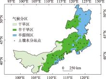
图1
内蒙古气候分区及土壤水分站点分布 注:底图采用自然资源部标准地图制作,审图号为GS(2020)4630号,对底图边界无修改。下同。"

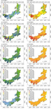
图2
五套土壤质地数据(0~30 cm)中砂土和黏土在内蒙古的空间分布"

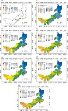
图3
2016—2020年0~10 cm平均土壤水分观测值(a)与六套模拟土壤水分值空间分布(b~g)"

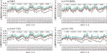
图4
2016—2020年5—9月内蒙古及其三个气候分区的每旬0~10 cm土壤水分的时间序列"

表1
内蒙古及其三个气候分区0~10 cm CLDAS和五组模拟土壤水分分别与观测值的相关系数、平均绝对偏差、均方根误差和克林-古普塔效率系数"
| 区域 | CLDAS | FAO | BNU | |||||||||||
|---|---|---|---|---|---|---|---|---|---|---|---|---|---|---|
| R | MAE /(m3·m-3) | RMSE /(m3·m-3) | KGE | R | MAE /(m3·m-3) | RMSE /(m3·m-3) | KGE | R | MAE /(m3·m-3) | RMSE /(m3·m-3) | KGE | |||
| 内蒙古 | 0.816 | 0.081 | 0.082 | 0.317 | 0.818 | 0.069 | 0.070 | 0.430 | 0.836 | 0.042 | 0.044 | 0.621 | ||
| 区内半 湿润区 | 0.780 | 0.0701 | 0.074 | 0.556 | 0.814 | 0.062 | 0.065 | 0.592 | 0.805 | 0.028 | 0.032 | 0.709 | ||
| 区内半 干旱区 | 0.823 | 0.085 | 0.086 | 0.226 | 0.876 | 0.072 | 0.072 | 0.379 | 0.887 | 0.047 | 0.048 | 0.567 | ||
| 区内干 旱区 | 0.505 | 0.070 | 0.075 | 0.198 | 0.250 | 0.068 | 0.072 | -0.018 | 0.375 | 0.045 | 0.050 | 0.200 | ||
| 区域 | CAS | GSDE | SNSS | |||||||||||
| R | MAE /(m3·m-3) | RMSE /(m3·m-3) | KGE | R | MAE /(m3·m-3) | RMSE /(m3·m-3) | KGE | R | MAE /(m3·m-3) | RMSE /(m3·m-3) | KGE | |||
| 内蒙古 | 0.841 | 0.049 | 0.051 | 0.564 | 0.835 | 0.044 | 0.045 | 0.610 | 0.855 | 0.034 | 0.036 | 0.687 | ||
| 区内半 湿润区 | 0.822 | 0.038 | 0.042 | 0.706 | 0.806 | 0.029 | 0.033 | 0.714 | 0.815 | 0.019 | 0.023 | 0.734 | ||
| 区内半 干旱区 | 0.888 | 0.054 | 0.056 | 0.490 | 0.886 | 0.048 | 0.049 | 0.551 | 0.900 | 0.041 | 0.042 | 0.616 | ||
| 区内干 旱区 | 0.413 | 0.042 | 0.046 | 0.231 | 0.383 | 0.044 | 0.049 | 0.211 | 0.477 | 0.032 | 0.037 | 0.327 | ||
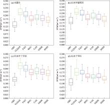
图5
内蒙古及其三个气候分区平均观测土壤湿度、CLDAS和五组模拟土壤水分箱线图"

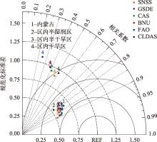
图6
2016—2020年5—9月内蒙古及其三个气候分区CLDAS及五组模拟土壤水分旬平均时间序列相对于观测值的Taylor图"

| [1] |
周广胜, 周梦子, 周莉, 等. 陆-气相互作用研究展望[J]. 地球科学进展, 2024, 39(7): 661-670.
doi: 10.11867/j.issn.1001-8166.2024.045 |
|
[Zhou Guangsheng, Zhou Mengzi, Zhou Li, et al. Prospects for land-atmosphere interaction[J]. Advances in Earth Science, 2024, 39(7): 661-670. ]
doi: 10.11867/j.issn.1001-8166.2024.045 |
|
| [2] | Santanello Jr J A, Dirmeyer P A, Ferguson C R, et al. Land-atmosphere interactions: The LoCo perspective[J]. Bulletin of the American Meteorological Society, 2018, 99(6): 1253-1272. |
| [3] | 林朝晖, 刘辉志, 谢正辉, 等. 陆面水文过程研究进展[J]. 大气科学, 2008, 32(4): 935-949. |
| [Lin Zhaohui, Liu Huizhi, Xie Zhenghui, et al. Recent progress in the land-surface and hydrological process studies[J]. Chinese Journal of Atmospheric Sciences, 2008, 32(4): 935-949. ] | |
| [4] | Chahine T M. The hydrological cycle and its influence on climate[J]. Nature, 1992, 359: 373-380. |
| [5] | Santanello J A, Kumar S V, Peters-Lidard C D, et al. Impact of soil moisture assimilation on land surface model spin-up and coupled land-atmosphere prediction[J]. Journal of Hydrometeorology, 2016, 17(2): 517-540. |
| [6] |
Ferguson C R, Agrawal S, Beauharnois M C, et al. Assimilation of satellite-derived soil moisture for improved forecasts of the Great Plains low-level jet[J]. Monthly Weather Review, 2020, 148(11): 4607-4627.
doi: 10.1175/MWR-D-20-0185.1 |
| [7] |
陈海山, 杜新观, 孙悦. 陆面过程与天气研究[J]. 地学前缘, 2022, 29(5): 382-400.
doi: 10.13745/j.esf.sf.2021.9.59 |
|
[Chen Haishan, Du Xinguan, Sun Yue. Land surface processes and weather research—a review[J]. Earth Science Frontiers, 2022, 29(5): 382-400. ]
doi: 10.13745/j.esf.sf.2021.9.59 |
|
| [8] |
薛智暄, 张丽, 王新军, 等. 古尔班通古特沙漠SMAP土壤水分产品降尺度分析[J]. 干旱区研究, 2023, 40(4): 583-593.
doi: 10.13866/j.azr.2023.04.07 |
|
[Xue Zhixuan, Zhang Li, Wang Xinjun, et al. Downscaling analysis of SMAP soil moisture products in Gurbantunggut Desert[J]. Arid Zone Research, 2023, 40(4): 583-593. ]
doi: 10.13866/j.azr.2023.04.07 |
|
| [9] | 宋海清, 朱仲元, 李云鹏. 6套格点土壤水分数据集在内蒙古自治区的适用性评价[J]. 水土保持通报, 2022, 41(6): 180-189, 200. |
| [Song Haiqing, Zhu Zhongyuan, Li Yunpeng. Applicability evaluation of six gridded soil moisture datasets in Inner Mongolia Autonomous Region[J]. Bulletin of Soil and Water Conservation, 2022, 41(6): 180-189, 200. ] | |
| [10] | 熊明明, 陈海山, 俞淼. CLM3.0对中国区域陆面过程的模拟试验及评估Ⅱ: 土壤湿度[J]. 气象科学, 2011, 31(1): 1-10. |
| [Xiong Mingming, Chen Haishan, Yu Miao. Simulation of land surface processes over China and its validation. PartⅡ: Soil moisture[J]. Journal of the Meteorological Sciences, 2011, 31(1): 1-10. ] | |
| [11] | Li Mingxing, Ma Zhuguo, Niu Guoyue. Modeling spatial and temporal variations in soil moisture in China[J]. Chinese Science Bulletin, 2011, 56(17): 1809-1820. |
| [12] | 王迪, 沈润平, 师春香, 等. CLM4.5对中国区域夏季土壤湿度的模拟研究[J]. 科学技术与工程, 2015, 15(17): 10-17. |
| [Wang Di, Shen Runping, Shi Chunxiang, et al. Simulation for China’s soil moisture by CLM4.5 in summer season[J]. Science Technology and Engineering, 2015, 15(17): 10-17. ] | |
| [13] | 韩帅, 师春香, 姜立鹏, 等. CLDAS土壤湿度模拟结果及评估[J]. 应用气象学报, 2017, 28(3): 369-378. |
| [Han Shuai, Shi Chunxiang, Jiang Lipeng, et al. The simulation and evaluation of soil moisture based on CLDAS[J]. Journal of Applied Meteorological Science, 2017, 28(3): 369-378. ] | |
| [14] | 师春香, 姜立鹏, 朱智, 等. 基于CLDAS2.0驱动数据的中国区域土壤湿度模拟与评估[J]. 江苏农业科学, 2018, 46(4): 231-236. |
| [Shi Chunxiang, Jiang Lipeng, Zhu Zhi, et al. Simulation and assessment of China’s regional soil moisture based on CLDAS2.0 forcing data[J]. Jiangsu Agricultural Sciences, 2018, 46(4): 231-236. ] | |
| [15] | Xia Y, Ek M B, Wu Y, et al. Comparison of NLDAS-2 simulated and NASMD observed daily soil moisture Part I: Comparison and analysis[J]. Journal of Hydrometeorology, 2015, 16(5): 1962-1980. ] |
| [16] | 吴龙刚, 王爱慧, 盛炎平. 土壤质地对中国区域陆面过程模拟的影响[J]. 气候与环境研究, 2014, 19(5): 559-571. |
| [Wu Longgang, Wang Aihui, Sheng Yanping. Impact of soil texture on the simulation of land surface processes in China[J]. Climatic and Environmental Research, 2014, 19(5): 559-571. ] | |
| [17] | 梁晓, 戴永久. 通用陆面模式对土壤质地和亮度的敏感性分析[J]. 气候与环境研究, 2008, 13(5): 585-597. |
| [Liang Xiao, Dai Yongjiu. A sensitivity study of the common land model on soil texture and soil brightness[J]. Climatic and Environmental Research, 2008, 13(5): 585-597. ] | |
| [18] | 戴秋丹, 郭振海, 王龙欢, 等. CLM4.5模式模拟安徽省淮南山地森林陆气交换过程[J]. 大气科学, 2025, 49(1): 23-37. |
| [Dai Qiudan, Guo Zhenhai, Wang Longhuan, et al. Simulating land and atmosphere exchange processes over a mountainous forest in Huainan of Anhui Province using CLM4.5 model[J]. Chinese Journal of Atmospheric Sciences, 2025, 49(1): 23-37. ] | |
| [19] | 李文耀, 魏楠, 黄丽娜, 等. 土壤数据集对全球陆面过程模拟的影响[J]. 气候与环境研究, 2020, 25(5): 555-574. |
| [Li Wenyao, Wei Nan, Huang Lina, et al. Impact of soil datasets on the global simulation of land surface processes[J]. Climatic and Environmental Research, 2020, 25(5): 555-574. ] | |
| [20] | Lazić I, Djurdjević V, Tošić I, et al. Impact of soil texture in coupled regional climate model on land-atmosphere interactions[J]. Theoretical and Applied Climatology, 2025, 156(165): 1-23. |
| [21] | Livneh B, Kumar R, Samaniego L. Influence of soil textural properties on hydrologic fluxes in the Mississippi River Basin[J]. Hydrological Processes, 2015, 29(21): 4638-4655. |
| [22] | Dy C Y, Fung J C H. Updated global soil map for the weather research and forecasting model and soil moisture initialization for the Noah land surface model[J]. Journal of Geophysical Research: Atmospheres, 2016, 121(15): 8777-8800. |
| [23] | 宋海清, 李云鹏, 师春香, 等. 内蒙古地区下垫面变化对土壤湿度数值模拟的影响[J]. 大气科学, 2016, 40(6): 1165-1181. |
| [Song Haiqing, Li Yunpeng, Shi Chunxiang, et al. Impact of underlying surface change on the numerical simulation of soil moisture in Inner Mongolia of China[J]. Chinese Journal of Atmospheric Sciences, 2016, 40(6): 1165-1181. ] | |
| [24] | 顾润源. 内蒙古自治区天气预报手册[M]. 北京: 气象出版社, 2012. |
| [Gu Runyuan. Inner Mongolia Weather Forecast Manual[M]. Beijing: China Meteorological Press, 2012. ] | |
| [25] | Reynolds C A, Jackson T J, Rawls W J. Estimating soil water-holding capacities by linking the Food and Agriculture Organization soil map of the world with global pedon databases and continuous pedotransfer functions[J]. Water Resources Research, 2000, 36(12): 3653-3662. |
| [26] | Oleson K W, Niu G Y, Yang Z L, et al. Improvements to the community land model and their impact on the hydrological cycle[J]. Journal of Geophysical Research: Biogeosciences, 2008, 113(G01021): 1-26. |
| [27] | Shangguan W, Dai Y, Liu B, et al. A China data set of soil properties for land surface modeling[J]. Journal of Advances in Modeling Earth Systems, 2013, 5(2): 212-224. |
| [28] |
Liu F, Wu H, Zhao Y, et al. Mapping high resolution national soil information grids of China[J]. Science Bulletin, 2022, 67(3): 328-340.
doi: 10.1016/j.scib.2021.10.013 pmid: 36546081 |
| [29] | Shangguan W, Dai Y, Duan Q, et al. A global soil data set for earth system modeling[J]. Journal of Advances in Modeling Earth Systems, 2014, 6(1): 249-263. |
| [30] | Shangguan W, Dai Y, Liu B, et al. A soil particle-size distribution dataset for regional land and climate modelling in China[J]. Geoderma, 2012, 171: 85-91. |
| [31] | Yang F, Lu H, Yang K, et al. Evaluation and comparison among multiple forcing data sets for precipitation and shortwave radiation over the mainland of China[J]. Hydrology and Earth System Sciences Discussions, 2017, 21(11): 1-32. |
| [32] | 宋海清. 内蒙古中东部草原区土壤水热过程对区域天气的影响研究[D]. 呼和浩特: 内蒙古农业大学, 2021. |
| [Song Haiqing. Effects of Soil Water and Heat Processes on Regional Weather in Central and Eastern Inner Mongolia Grassland[D]. Hohhot: Inner Mongolia Agricultural University, 2021. ] | |
| [33] | He J, Yang K, Tang W, et al. The first high-resolution meteorological forcing dataset for land process studies over China[J]. Scientific Data, 2020, 7(25): 1-11. |
| [34] |
宋海清, 朱仲元, 李云鹏. 陆面同化及再分析降水资料在内蒙古地区的适用性[J]. 干旱区研究, 2021, 38(6): 1624-1636.
doi: 10.13866/j.azr.2021.06.14 |
|
[Song Haiqing, Zhu Zhongyuan, Li Yunpeng. Validation of land data assimilation and reanalysis precipitation datasets over Inner Mongolia[J]. Arid Zone Research, 2021, 38(6): 1624-1636. ]
doi: 10.13866/j.azr.2021.06.14 |
|
| [35] |
刘川, 余晔, 解晋, 等. 多套土壤温湿度资料在青藏高原的适用性[J]. 高原气象, 2015, 34(3): 653-665.
doi: 10.7522/j.issn.1000-0534.2015.00034 |
|
[Liu Chuan, Yu Ye, Xie Jin, et al. Applicability of soil temperature and moisture in several datasets over Qinghai-Xizang Plateau[J]. Plateau Meteorology, 2015, 34(3): 653-665. ]
doi: 10.7522/j.issn.1000-0534.2015.00034 |
|
| [36] | Taylor K E. Summarizing multiple aspects of model performance in a single diagram[J]. Journal of Geophysical Research: Atmospheres, 2001, 106(D7): 7183-7192. |
| [39] |
[Yang Yaqing, Zhang Chong, Zhang Jie, et al. Changes in soil moisture and dryness and their response to climate change in the Guanzhong region[J]. Arid Zone Research, 2024, 41(2): 261-271. ]
doi: 10.13866/j.azr.2024.02.09 |
| [37] | Decker M, Zeng X. Impact of modified Richards equation on global soil moisture simulation in the Community Land Model (CLM3.5)[J]. Journal of Advances in Modeling Earth Systems, 2009, 1(5): 1-22. |
| [38] | 赖欣, 文军, 岑思弦, 等. CLM4.0模式对中国区域土壤湿度的数值模拟及评估研究[J]. 大气科学, 2014, 38(3): 499-512. |
| [Lai Xin, Wen Jun, Cen Sixian, et al. Numerical simulation and evaluation study of soil moisture over China by using CLM4.0 model[J]. Chinese Journal of Atmospheric Sciences, 2014, 38(3): 499-512. ] | |
| [39] |
杨雅青, 张翀, 张婕, 等. 关中地区土壤干湿变化及对气候的响应[J]. 干旱区研究, 2024, 41(2): 261-271.
doi: 10.13866/j.azr.2024.02.09 |
| [1] | 李漠雨, 董少睿, 郭英香. 青藏高原东部三种降水数据产品的适用性评估[J]. 干旱区研究, 2025, 42(7): 1173-1183. |
| [2] | 张雅静, 郝蕊芳. 中国北方农牧交错带东段不同类型流域水文模型适用性[J]. 干旱区研究, 2025, 42(6): 1021-1031. |
| [3] | 吴绍雄, 马登科, 陈昆, 计桂平, 何志斌. 基于移动式宇宙射线中子技术的区域尺度土壤墒情监测研究[J]. 干旱区研究, 2025, 42(5): 810-819. |
| [4] | 刘玥, 郭强, 袁立敏, 党晓宏, 蒙仲举, 董菁. 三种植物基固沙剂对风沙土水分入渗和蒸发的影响[J]. 干旱区研究, 2025, 42(4): 658-667. |
| [5] | 孟庆帅, 巩钰, 刘小燕, 童新, 王东民, 谢国英, 刘廷玺. 水资源-社会经济-生态环境耦合协调度关系研究及预测——以黄河流域内蒙古段为例[J]. 干旱区研究, 2025, 42(4): 682-694. |
| [6] | 衣娜娜, 毕力格, 史金丽, 蔡敏, 许志丽, 郑凤杰, 丽娜. 内蒙古大兴安岭飞机冷云增雨潜势预报模型[J]. 干旱区研究, 2025, 42(3): 409-419. |
| [7] | 刘鑫, 王利群, 李昊然, 李永红, 乔文光, 李丽娟, 王晨旭. 基于“服务重要性-生态敏感性-生物多样性”的内蒙古生态网络识别及优化[J]. 干旱区研究, 2024, 41(7): 1207-1216. |
| [8] | 李冰洁, 范志韬, 曲芷程, 姚顺予, 宿夏姝, 刘东伟, 王立新. 基于InVEST-PLUS模型的黄河流域内蒙古段生态系统碳储量评价及预测[J]. 干旱区研究, 2024, 41(7): 1217-1227. |
| [9] | 叶虎, 裴浩, 姜艳丰, 那庆, 张立伟. 内蒙古半干旱区气溶胶散射特性及影响因素[J]. 干旱区研究, 2024, 41(5): 730-741. |
| [10] | 赵立超, 张成福, 贺帅, 苗林, 冯霜, 潘思涵. 复杂山区地表温度模拟及影响——以内蒙古大青山为例[J]. 干旱区研究, 2024, 41(5): 765-775. |
| [11] | 杨竹青, 王磊, 张雪, 申建香, 张伊婧, 李欣宇, 张波, 牛金帅. 典型固沙植物种子萌发和幼苗生长对土壤水分的响应[J]. 干旱区研究, 2024, 41(5): 830-842. |
| [12] | 胡广录, 刘鹏, 李嘉楠, 陶虎, 周成乾. 黑河中游绿洲边缘三种景观类型土壤水分动态特征及影响因素[J]. 干旱区研究, 2024, 41(4): 550-565. |
| [13] | 张华, 押海廷, 徐存刚. 兰州市南北两山土壤水分遥感反演及植被需水量估算[J]. 干旱区研究, 2024, 41(4): 566-580. |
| [14] | 宋达成, 马全林, 刘世权, 魏林源, 吴昊, 段晓峰, 郭树江. 民勤黏土沙障-人工梭梭林物种多样性及土壤水分变化特征[J]. 干旱区研究, 2024, 41(4): 618-628. |
| [15] | 裴志林, 曹晓娟, 王冬, 李迪, 王鑫, 白艾原. 内蒙古植被覆盖时空变化特征及其对人类活动的响应[J]. 干旱区研究, 2024, 41(4): 629-638. |
|
||