干旱区研究 ›› 2025, Vol. 42 ›› Issue (10): 1828-1840.doi: 10.13866/j.azr.2025.10.07 cstr: 32277.14.AZR.20251007
何戬兰1( ), 闫庆武1, 陈奕云2, 李珂颀1, 白俊平3, 吴子豪1()
收稿日期:2025-04-23
修回日期:2025-07-21
出版日期:2025-10-15
发布日期:2025-10-22
通讯作者:
吴子豪. E-mail: wuzh@cumt.edu.cn作者简介:何戬兰(2000-),女,硕士研究生,主要从事干旱半干旱区数字土壤制图研究. E-mail: hhhjl@cumt.edu.cn
基金资助:
HE Jianlan1(), YAN Qingwu1, CHEN Yiyun2, LI Keqi1, BAI Junping3, WU Zihao1()
Received:2025-04-23
Revised:2025-07-21
Published:2025-10-15
Online:2025-10-22
摘要:
精准刻画天山中段土壤有机碳(Soil Organic Carbon,SOC)的空间格局并揭示其主要影响因子,对于评估土壤质量、实现固碳增汇和保障生态安全具有重要意义。然而,由于天山地区内,尤其是近天山地区和远离天山地区的地形、降雨量、蒸发量、植被覆盖和土壤pH差异显著,整体生态条件复杂,导致区域SOC存在高度空间异质性,这为利用数字土壤制图技术实现SOC精确制图带来了极大的挑战。本文基于463个土壤采样数据,结合极限梯度提升树(eXtreme Gradient Boosting,XGB)等多种机器学习模型获取了SOC的空间分布图,并使用SHAP(Shapley Additive exPlanations)算法揭示了SOC空间分异的主要影响因子。结果表明:XGB模型的拟合效果最优,其拟合R2达到0.716、LCCC达到0.824,而RMSE仅为1.554 g·kg-1。该地区SOC的空间分布呈现出北高南低的特征。通过SHAP算法进一步发现,该地区SOC含量主要受到pH、海拔与年均降水量的影响。且偏依赖图结果表明,环境变量与SOC均存在阈值效应。当pH高于7.8、年均蒸发量高于620 mm,或年均降雨量低于300 mm、植被净初级生产力低于130 g C·m-2·a-1时,SOC含量骤降,这表明控制土壤pH、蒸散量、植被的生长情况有利于区域土壤固碳增汇。应该通过使用酸性改良剂、施用有机肥、保证农业灌溉等手段调节该地区影响SOC的关键变量的取值,进而实现提升SOC含量的目标。本研究证实了考虑土壤pH、海拔、年均降水量等变量的重要性,研究成果为天山中段土壤碳汇管理提供了数据支撑,也为其他干旱半干旱地区的SOC数字制图提供了参考。
何戬兰, 闫庆武, 陈奕云, 李珂颀, 白俊平, 吴子豪. 天山中段土壤有机碳空间预测及主控因子分析[J]. 干旱区研究, 2025, 42(10): 1828-1840.
HE Jianlan, YAN Qingwu, CHEN Yiyun, LI Keqi, BAI Junping, WU Zihao. Spatial prediction and master factors of soil organic carbon in the middle section of Tianshan Mountains[J]. Arid Zone Research, 2025, 42(10): 1828-1840.
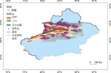
图1
研究区位置及采样点分布 注:底图采用国家地理信息公共服务平台标准地图制作,审图号为GS(2024)0650,对底图边界无修改。下同。"
表1
环境变量信息"
| 类别 | 影响因子 | 空间分辨率 | 数据来源 |
|---|---|---|---|
| 土壤属性(S) | 土壤类型 | 1 km | 国家地球系统科学数据中心( |
| 粉粒含量 | |||
| 砂粒含量 | |||
| 黏粒含量 | |||
| 全氮 | 90 m | ||
| 全磷 | |||
| 全钾 | |||
| pH | |||
| 砾石含量 | |||
| 土壤厚度 | |||
| 土壤湿度 | 0.05° | 国家生态科学数据中心( | |
| 气候因子(C) | 年均气温 | 1 km | 国家青藏高原科学数据中心( |
| 年均降水量 | |||
| 年均蒸发量 | |||
| 有机体(O) | 土地利用类型 | 1 km | 资源环境科学与数据平台( |
| 最大NDVI | 国家生态科学数据中心( | ||
| 植被净初级生产力 | 国家地球系统科学数据中心( | ||
| 人口密度 | 1 km | WorldPop( | |
| 地形因子(R) | 海拔 | 1 km | 地理空间数据云( |
| 坡度 |

图2
环境变量空间分布"

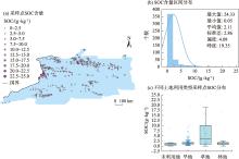
图3
研究区SOC描述性统计结果"

表2
模型性能表现"
| 模型 | 拟合R2 | 预测R2 | RMSE | LCCC |
|---|---|---|---|---|
| GWR | 0.746 | -0.827 | 3.702 | -0.018 |
| CNN | 0.716 | 0.668 | 1.673 | 0.782 |
| DNN | 0.725 | 0.680 | 1.616 | 0.800 |
| GBDT | 0.920 | 0.682 | 2.507 | 0.778 |
| RF | 0.905 | 0.688 | 1.576 | 0.808 |
| XGB | 0.903 | 0.716 | 1.554 | 0.824 |

图4
环境变量的相对重要性"


图5
各采样点SOC的主要及次要影响因子"
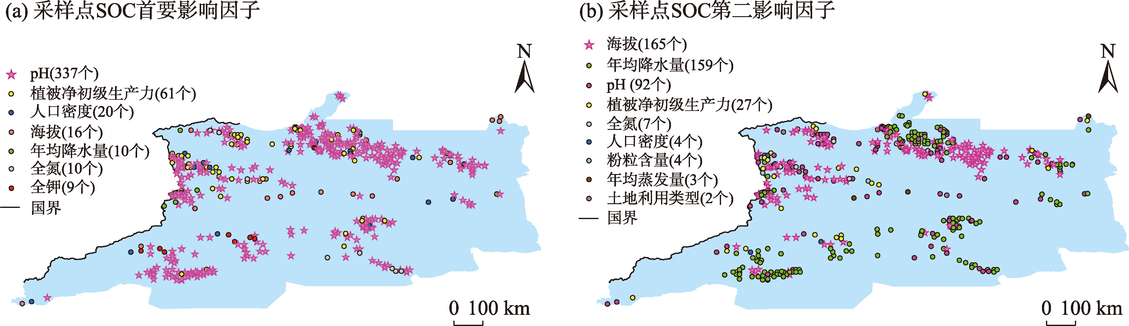
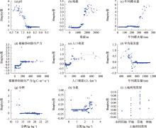
图6
Shapley值与环境变量的偏依赖图"


图7
SOC空间分布及不确定性"

| [1] | Chappell E, Easher T H, Saurette D, et al. Soil Organic Carbon:Past, Present, and Future Research[M]. Germany: Springer, 2021: 35-48. |
| [2] | Kuht J, Eremeev V, Talgre L, et al. Changes in the soil microbial hydrolytic activity and the content of organic carbon and total nitrogen by growing spring barley undersown with red clover in different farming systems[J]. Agriculture, 2019, 9(7): 146. |
| [3] | 张杰, 李敏, 敖子强, 等. 中国西部干旱区土壤有机碳储量估算[J]. 干旱区资源与环境, 2018, 32(9): 132-137. |
| [Zhang Jie, Li Min, Ao Ziqiang, et al. Estimation of soil organic carbon storage of terrestrial ecosystem in arid western China[J]. Journal of Arid Land Resources and Environment, 2018, 32(9): 132-137. ] | |
| [4] | Zhuo Z, Chen Q, Zhang X, et al. Soil organic carbon storage, distribution, and influencing factors at different depths in the dryland farming regions of Northeast and North China[J]. Catena, 2022, 21005934Z: Doi: 10.1016/j.catena.2021.105934. |
| [5] | 缪琦, 史学正, 于东升, 等. 气候因子对森林土壤有机碳影响的幅度效应研究[J]. 土壤学报, 2010, 47(2): 270-278. |
| [Liao Qi, Shi Xuezheng, Yu Dongsheng, et al. Scale effect of climatic factors on forest soil organic carbon[J]. Acta Pedologica Sinica, 2010, 47(2): 270-278. ] | |
| [6] | Yang L, Jia W, Shi Y, et al. Spatiotemporal differentiation of soil organic carbon of grassland and its relationship with soil physicochemical properties on the northern slope of Qilian Mountains, China[J]. Sustainability, 2020, 12(22): 9396. |
| [7] |
常帅, 于红博, 曹聪明, 等. 锡林郭勒草原土壤有机碳分布特征及其影响因素[J]. 干旱区研究, 2021, 38(5): 1355-1366.
doi: 10.13866/j.azr.2021.05.17 |
|
[Chang Shuai, Yu Hongbo, Cao Congming, et al. Distribution characteristics of soil organic carbon in Xilin Gol steppe and its influencing factors[J]. Arid Zone Research, 2021, 38(5): 1355-1366. ]
doi: 10.13866/j.azr.2021.05.17 |
|
| [8] | 韩雅, 朱文博, 李双成. 基于GWR模型的中国NDVI与气候因子的相关分析[J]. 北京大学学报(自然科学版), 2016, 52(6): 1125-1133. |
| [Han Ya, Zhu Wenbo, Li Shuangcheng. Modelling relationship between NDVI and climatic factors in China: Using geographically weighted regression[J]. Acta Scientiarum Naturalium Universitatis Pekinensis, 2016, 52(6): 1125-1133. ] | |
| [9] | 宋颖, 高明秀, 王佳凡, 等. 基于MGWR的滨海区土壤盐渍化分布空间预测及影响因素分析[J]. 环境科学, 2024, 45(7): 4293-4301. |
| [Song Ying, Gao Mingxiu, Wang Jiafan, et al. Spatial prediction and influencing factors analysis of soil salinization in coastal area based on MGWR[J]. Environmental Science, 2024, 45(7): 4293-4301. ] | |
| [10] | Hagenauer J, Helbich M. A geographically weighted artificial neural network[J]. International Journal of Geographical Information Science, 2022, 36(2): 215-235. |
| [11] | Wu Z, Chen Y, Yang Z, et al. Mapping soil organic carbon in low-relief farmlands based on stratified heterogeneous relationship[J]. Remote Sensing, 2022, 14(15): 3575. |
| [12] | Zhang C, Chen Y Y, Wei Y J, et al. Unraveling the threshold and interaction effects of environmental variables on soil organic carbon mapping in plateau watershed[J]. Geoderma, 2024, 450: 117032. |
| [13] | Zheng Y T, Zhao X N, Li X Y, et al. Mapping soil organic carbon density via geographically weighted regression with smooth terms: A case study in Shanxi Province[J]. Ecological Indicators, 2024, 166: 112588. |
| [14] | Chakraborty S K, Chandel N S, Jat D, et al. Deep learning approaches and interventions for futuristic engineering in agriculture[J]. Neural Computing & Applications, 2022, 34(23): 20539-20573. |
| [15] |
Padarian J, Minasny B, Mcbratney A B. Machine learning and soil sciences: A review aided by machine learning tools[J]. Soil, 2020, 6(1): 35-52.
doi: 10.5194/soil-6-35-2020 |
| [16] | Biau G, Scornet E. A random forest guided tour[J]. Test, 2016, 25(2): 197-227. |
| [17] | Breiman L. Random forests[J]. Machine Learning, 2001, 45(1): 5-32. |
| [18] | Friedman J H. Greedy function approximation: A gradient boosting machine[J]. Annals of Statistics, 2001, 29(5): 1189-1232. |
| [19] | Liang W, Luo S, Zhao G, et al. Predicting hard rock pillar stability using GBDT, XGBoost, and LightGBM algorithms[J]. Mathematics, 2020, 8(5): 765. |
| [20] | Chen T Q, Guestrin C. XGBoost: A scalable tree boosting system[C]// Assoc Comp M. Proceedings of the 22nd ACM SIGKDD International Conference on Knowledge Discovery and Data Mining (KDD). San Francisco, CA: Assoc Computing Machinery, 2016: 785-794. |
| [21] | Pathy A, Meher S, Balasubramanian P. Predicting algal biochar yield using eXtreme Gradient Boosting (XGB) algorithm of machine learning methods[J]. Algal Research-Biomass Biofuels and Bioproducts, 2020, 50: 102006. |
| [22] |
Passafaro T L, Lopes F B, Dórea J R R, et al. Would large dataset sample size unveil the potential of deep neural networks for improved genome-enabled prediction of complex traits? The case for body weight in broilers[J]. Bmc Genomics, 2020, 21(1): 771.
doi: 10.1186/s12864-020-07181-x pmid: 33167865 |
| [23] | Shruti P, Rekha R. A review of convolutional neural networks, its variants and applications[C]// 2023 International Conference on Intelligent Systems for Communication, IoT and Security (ICISCoIS), 2023, 31-36. |
| [24] | Lundberg S M, Lee S-I. A unified approach to interpreting model predictions[C]// Proceedings of the 31st Annual Conference on Neural Information Processing Systems (NIPS). Long Beach, CA: Neural Information Processing Systems (NIPS), 2017: 4768-4777. |
| [25] | Islam M T, Xing L. Deciphering the feature representation of deep neural networks for high-performance AI[J]. Ieee Transactions on Pattern Analysis and Machine Intelligence, 2024, 46(8): 5273-5287. |
| [26] | Liu Q, Wang X D. Designing an efficient framework for large-scale data processing and analysis based on deep learning technology[C]// Assoc Comp M. Proceedings of the 3rd International Conference on Cyber Security, Artificial Intelligence and Digital Economy (CSAIDE). Nanjing: Assoc Computing Machinery, 2024: 269-274. |
| [27] | Wang S, Zhang Z, Geng S, et al. Research on optimization of random forest algorithm based on Spark[J]. Cmc-Computers Materials & Continua, 2022, 71(2): 3721-3731. |
| [28] | Shao Q, Xu Y M, Wu H Y. Spatial prediction of COVID-19 in China based on machine learning algorithms and geographically weighted regression[J]. Computational and Mathematical Methods in Medicine, 2021, 2021: 7196492. |
| [29] | Anding K, Haar L, Polte G, et al. Comparison of the performance of innovative deep learning and classical methods of machine learning to solve industrial recognition tasks[C]// Proceedings of the Joint TC1-TC2 International Symposium on Photonics and Education in Measurement Science. Germany: Spie-Int SOC Optical Engineering, 2019: UNSP 111440R. |
| [30] | Shwartz-Ziv R, Armon A. Tabular data: Deep learning is not all you need[J]. Information Fusion, 2021, 81: 84-90. |
| [31] | 洪岩, 袁琳, 李梦雪, 等. 产品生命周期视域下人工智能技术在服装产业中的应用进展[J]. 丝绸, 2024, 61(12): 1-22. |
| [Hong Yan, Yuan Lin, Li Mengxue, et al. Progress in the application of artificial intelligence technology in the garment industry from the perspective of product life cycle[J]. Journal of Silk, 2024, 61(12): 1-22. ] | |
| [32] | 李升波, 关阳, 侯廉, 等. 深度神经网络的关键技术及其在自动驾驶领域的应用[J]. 汽车安全与节能学报, 2019, 10(2): 119-145. |
| [Li Shengbo, Guan Yang, Hou Lian, et al. Key technique of deep neural network and its applications in autonomous driving[J]. Journal of Automotive Safety and Energy, 2019, 10(2): 119-145. ] | |
| [33] | 田芳, 周孝信, 史东宇, 等. 基于卷积神经网络的电力系统暂态稳定预防控制方法[J]. 电力系统保护与控制, 2020, 48(18): 1-8. |
| [Tian Fang, Zhou Xiaoxin, Shi Dongyu, et al. A preventive control method of power system transient stability based on a convolutional neural network[J]. Power System Protection and Control, 2020, 48(18): 1-8. ] | |
| [34] | 冯锦, 崔东, 孙国军, 等. 新疆土壤有机碳与土壤理化性质的相关性[J]. 草业科学, 2017, 34(4): 692-697. |
| [Feng Jin, Cui Dong, Sun Guojun, et al. Soil organic carbon in relation to soil physicochemical properties in Xinjiang[J]. Pratacultural Science, 2017, 34(4): 692-697. ] | |
| [35] |
马辉英, 李昕竹, 马鑫钰, 等. 新疆天山北麓中段不同植被类型下土壤有机碳组分特征及其影响因素[J]. 生态环境学报, 2022, 31(6): 1124-1131.
doi: 10.16258/j.cnki.1674-5906.2022.06.007 |
| [Ma Huiying, Li Xinzhu, Ma Xinyu, et al. Characteristics and driving factors of soil organic carbon fractions under different vegetation types of the mid-northern piedmont of the Tianshan Mountains, Xinjiang[J]. Ecology and Environmental Sciences, 2022, 31(6): 1124-1131. ] | |
| [36] | 傅华, 陈亚明, 王彦荣, 等. 阿拉善主要草地类型土壤有机碳特征及其影响因素[J]. 生态学报, 2004, 24(3): 469-476. |
| [Fu Hua, Chen Yaming, Wang Yanrong, et al. Organic carbon content in major grassland types in Alex, Inner Mongolia[J]. Acta Ecologica Sinica, 2004, 24(3): 469-476. ] | |
| [37] | 何志斌, 赵文智, 刘鹄, 等. 祁连山青海云杉林斑表层土壤有机碳特征及其影响因素[J]. 生态学报, 2006, 26(8): 2572-2577. |
| [He Zhibin, Zhao Wenzhi, Liu Hu, et al. Characteristic of Picea crassifolia forest soil organic carbon and relationship with environment factors in the Qilian Mountain[J]. Acta Ecologica Sinica, 2006, 26(8): 2572-2577. ] | |
| [38] | 刘伟, 程积民, 高阳, 等. 黄土高原草地土壤有机碳分布及其影响因素[J]. 土壤学报, 2012, 49(1): 68-76. |
| [Liu Wei, Cheng Jimin, Gao Yang, et al. Distribution of soil organic carbon in grassland on the Loess Plateau and its influencing factors[J]. Acta Pedologica Sinica, 2012, 49(1): 68-76. ] | |
| [39] |
聂祥琴, 陈瀚阅, 牛铮, 等. 基于时序影像的农业活动因子提取与闽西耕地SOC数字制图[J]. 地球信息科学学报, 2022, 24(9): 1835-1852.
doi: 10.12082/dqxxkx.2022.220015 |
| [Nie Xiangqin, Chen Hanyue, Niu Zheng, et al. Digital SOC mapping in croplands using agricultural activity factors derived from time-series data in western Fujian[J]. Journal of Geo-information Science, 2022, 24(9): 1835-1852. ] | |
| [40] |
李景, 吴会军, 武雪萍, 等. 长期免耕和深松提高了土壤团聚体颗粒态有机碳及全氮含量[J]. 中国农业科学, 2021, 54(2): 334-344.
doi: 10.3864/j.issn.0578-1752.2021.02.009 |
|
[Li Jing, Wu Huijun, Wu Xueping, et al. Long-term conservation tillage enhanced organic carbon and nitrogen contents of particulate organic matter in soil aggregates[J]. Scientia Agricultura Sinica, 2021, 54(2): 334-344. ]
doi: 10.3864/j.issn.0578-1752.2021.02.009 |
|
| [41] | 潘依依, 何云峰, 单立楠, 等. 沙漠化土壤有机碳研究进展[J]. 土壤通报, 2011, 42(6): 1515-1521. |
| [Pan Yiyi, He Yunfeng, Shan Linan, et al. A review on soil organic carbon during desertification progresses[J]. Chinese Journal of Soil Science, 2011, 42(6): 1515-1521. ] | |
| [42] | Iversen C, Norby R J S N. Global Environmental Change[M]. Germany: Springer Reference, 2014: 297-316. |
| [43] |
李玉露, 吴雪晴, 袁野, 等. 黑龙江省植被碳-水利用效率时空演变及其驱动机制[J]. 应用生态学报, 2024, 35(12): 3349-3358.
doi: 10.13287/j.1001-9332.202412.006 |
|
[Li Yulu, Wu Xueqing, Yuan Ye, et al. Spatial-temporal variation and driving mechanism of vegetation carbon and water use efficiency in Heilongjiang Province, China[J]. Chinese Journal of Applied Ecology, 2024, 35(12): 3349-3358. ]
doi: 10.13287/j.1001-9332.202412.006 |
|
| [44] | Tavakkoli E, Uddin S, Rengasamy P, et al. Field applications of gypsum reduce pH and improve soil C in highly alkaline soils in southern Australia’s dryland cropping region[J]. Soil Use and Management, 2022, 38(1): 466-477. |
| [45] | Zuo W, Xu L, Qiu M, et al. Effects of different exogenous organic materials on improving soil fertility in Coastal Saline-alkali soil[J]. Agronomy-Basel, 2023, 13(1): 61. |
| [46] | Zhang Y, Li F, Lu Z, et al. Organic amendments effects on soil aggregation and carbon sequestration in saline-alkaline croplands in China[J]. Agronomy Journal, 2023, 115(4): 2083-2095. |
| [1] | 石林奇, 马全林, 马瑞, 段晓峰, 魏林源. 腾格里沙漠南缘典型固沙植被土壤碳组分特征[J]. 干旱区研究, 2025, 42(8): 1451-1462. |
| [2] | 张佳凝, 张建军, 赖宗锐, 赵炯昌, 胡亚伟, 李阳, 卫朝阳. 林分密度对刺槐人工林土壤养分和微生物群落的影响[J]. 干旱区研究, 2025, 42(2): 274-288. |
| [3] | 邢欣然, 张祎, 李鹏, 刘晓君, 陶清瑞, 任正龑, 胥世斌. 模拟干湿条件下土壤酶活性对坝地土壤有机碳矿化的影响[J]. 干旱区研究, 2024, 41(11): 1969-1980. |
| [4] | 马继龙, 史军辉, 王新英, 阿丽亚·拜都热拉, 刘茂秀, 艾吉尔·阿不拉. 洪水漫溢对塔里木河中游河岸胡杨林土壤有机碳及活性组分的影响[J]. 干旱区研究, 2023, 40(8): 1248-1257. |
| [5] | 孟娜, 张颖. 山西省林地扩展优先区识别[J]. 干旱区研究, 2023, 40(1): 111-122. |
| [6] | 何超禄,吕海深,朱永华,李文韬,谢冰绮,徐凯莉,刘名文. TIGGE降水预报在中国干旱半干旱地区的适用性评估[J]. 干旱区研究, 2022, 39(2): 368-378. |
| [7] | 常帅,于红博,曹聪明,马梓策,刘月璇,李想. 锡林郭勒草原土壤有机碳分布特征及其影响因素[J]. 干旱区研究, 2021, 38(5): 1355-1366. |
| [8] | 史常明,柳洋,张富荣,赵云飞,肖锦锦,汪霞. 焉耆盆地绿洲农田不同类型土壤有机碳空间分布特征及储量估算[J]. 干旱区研究, 2021, 38(3): 672-681. |
| [9] | 刘丽贞,庞丹波,王新云,陈林,李学斌,吴梦瑶,刘波,祝忠有,李静尧,王继飞. 稳定碳同位素技术在土壤有机碳研究中的应用进展[J]. 干旱区研究, 2021, 38(1): 123-132. |
| [10] | 王美佳, 王沣, 苏思慧, 苏业涵, 孙悦, 王英俨, 孟广鑫, 姜英, 齐华. 秸秆还田对土壤水稳性团聚体及其碳分布的影响[J]. 干旱区研究, 2019, 36(2): 331-338. |
| [11] | 李典鹏, 孙涛, 姚美思, 刘隋赟昊, 王丽萍, 王辉, 贾宏涛. 盐湖区生态系统碳密度及其分配格局[J]. 干旱区研究, 2018, 35(4): 984-991. |
| [12] | 任广琦, 贾小旭, 贾玉华, 郭成久. 黄土高原南北样带土壤有机碳空间变异及其影响因素[J]. 干旱区研究, 2018, 35(3): 524-531. |
| [13] | 缑倩倩, 屈建军, 王国华, 肖建华, 庞营军. 中国干旱半干旱地区湿地研究进展[J]. 干旱区研究, 2015, 32(2): 213-220. |
| [14] | 王渊刚, 罗格平, 冯异星, 李超凡, 韩其飞, 范彬彬. 天山北麓不同土地覆被下土壤有机碳垂直分布特征[J]. 干旱区研究, 2013, 30(5): 913-918. |
| [15] | 苏建红, 朱新萍, 王新军, 贾宏涛, 赵成义, 胡玉昆, 李丽君. 长期围栏封育对亚高山草原土壤有机碳空间变异的影响[J]. 干旱区研究, 2012, 29(6): 997-1002. |
|
||