干旱区研究 ›› 2024, Vol. 41 ›› Issue (2): 220-229.doi: 10.13866/j.azr.2024.02.05 cstr: 32277.14.AZR.20240205
程秋连1,2( ), 刘杰1,2(), 杨治纬2, 张天意1,2, 王斌2
收稿日期:2023-06-27
修回日期:2023-10-16
出版日期:2024-02-15
发布日期:2024-03-11
作者简介:程秋连(1998-),女,硕士研究生,主要从事公路冰雪灾害研究. E-mail: 878583994@qq.com
基金资助:
CHENG Qiulian1,2(), LIU Jie1,2(), YANG Zhiwei2, ZHANG Tianyi1,2, WANG Bin2
Received:2023-06-27
Revised:2023-10-16
Published:2024-02-15
Online:2024-03-11
摘要:
拟建独库高速公路阿尔先沟段地貌以高山峡谷为主,由于降雪和气候变化,雪崩频发。利用无人机遥感解译与现场调研协同调查的方法识别92个雪崩点,选取高程、坡度、地表切割度、地面粗糙度,积雪期最大积雪深度、最大风速、平均温度和平均降雪量为驱动因子,运用地理探测器分析不同分辨率地形因子与雪崩稳定性的关系。结果表明:本研究区雪崩发育较为活跃,稳定性较差,但较多雪崩释放区、运动区位于山体坡面,堆积区位于远离拟建线路的谷底,对拟建线路影响较小。通过地理探测器分析,坡度、地面粗糙度对雪崩稳定性解释力与分辨率呈正相关,高程、地表切割度呈负相关,交互探测结果均是双因子增强或者非线性增强,且非线性增强比双因子增强更加显著,坡度与其他因子结合对雪崩稳定性影响至关重要。本研究可为雪崩易发性、危险性评价工作提供可靠的数据支撑,为独库高速公路的建设运营提供科学依据。
程秋连, 刘杰, 杨治纬, 张天意, 王斌. 独库高速阿尔先沟段雪崩空间分布及因子探测[J]. 干旱区研究, 2024, 41(2): 220-229.
CHENG Qiulian, LIU Jie, YANG Zhiwei, ZHANG Tianyi, WANG Bin. Spatial distribution and factor analysis of avalanche in the Aerxiangou section of the Duku expressway[J]. Arid Zone Research, 2024, 41(2): 220-229.

图1
研究区域图 注:底图采用自然资源部标准地图制作,审图号为GS(2020)4619号,对底图边界无修改。下同。"

表1
交互作用探测依据"
| 判断依据 | 交互图示 | 交互性 |
|---|---|---|
 | 非线性减弱 | |
 | 单因子非线性减弱 | |
 | 双因子增强 | |
 | 相互独立 | |
 | 非线性增强 |
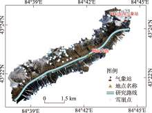
图2
无人机遥感解译雪崩分布"

表2
雪崩稳定性分类"
| 稳定性分级 | 雪崩数量/个 | 所占比例/% |
|---|---|---|
| 稳定 | 6 | 6.5 |
| 相对稳定 | 18 | 19.6 |
| 稳定性较差 | 45 | 48.9 |
| 不稳定 | 18 | 19.6 |
| 极其不稳定 | 5 | 5.4 |

图3
雪崩对拟建线路影响轨迹"

表3
对拟建高速公路影响分类"
| 对拟建线路的影响 | 雪崩数量/个 | 所占比例/% |
|---|---|---|
| 无影响 | 59 | 64.2 |
| 影响一般 | 12 | 13 |
| 影响较重 | 12 | 13 |
| 影响严重 | 9 | 9.8 |
表4
雪崩影响因子分类分级"
| 地形因子 | 气象积雪因子 | |||||
|---|---|---|---|---|---|---|
| 影响因子 | 分级区间 | 级别 | 影响因子 | 分级区间 | 级别 | |
| 高程/m | <2400 | Ⅰ | 平均温度/℃ | <-8.3 | Ⅰ | |
| 2400~2700 | Ⅱ | -8.3~-7.8 | Ⅱ | |||
| 2700~3000 | Ⅲ | -7.8~-7.4 | Ⅲ | |||
| 3000~3300 | Ⅳ | -7.4~-6.9 | Ⅳ | |||
| >3300 | Ⅴ | -6.9~-6.6 | Ⅴ | |||
| 坡度/m | 0~15 | Ⅰ | 平均降雪量/cm | <18 | Ⅰ | |
| 15~30 | Ⅱ | 18~19 | Ⅱ | |||
| 30~45 | Ⅲ | 19~20 | Ⅲ | |||
| 45~60 | Ⅳ | 20~21 | Ⅳ | |||
| >60 | Ⅴ | >21 | Ⅴ | |||
| 地表切割度/m | 0~30 | Ⅰ | 最大积雪深度/cm | <55 | Ⅰ | |
| 30~60 | Ⅱ | 55~57.5 | Ⅱ | |||
| 60~90 | Ⅲ | 57.5~60 | Ⅲ | |||
| 90~120 | Ⅳ | 60~62.5 | Ⅳ | |||
| >120 | Ⅴ | 62.5~65 | Ⅴ | |||
| 地面粗糙度 | 0~0.2 | Ⅰ | 最大风速/(m·s-1) | <15.6 | Ⅰ | |
| 0.2~0.4 | Ⅱ | 15.6~15.7 | Ⅱ | |||
| 0.4~0.6 | Ⅲ | 15.7~15.9 | Ⅲ | |||
| 0.6~0.8 | Ⅳ | 15.9~16.1 | Ⅳ | |||
| >0.8 | Ⅴ | >16.1 | Ⅴ | |||

图4
雪崩地形因子的分类数量和比例特征"


图5
雪崩气象因子的分类数量和比例特征"

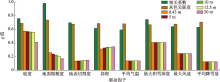
图6
单因子探测结果"

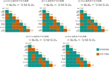
图7
不同分辨率地形因子交互探测结果"

| [1] | 胡汝骥, 马维林, 王存牛. 中国天山的雪崩及其治理[J]. 冰川冻土, 1987, 9(S1): 13-24, 150. |
| [Hu Ruji, Ma Weilin, Wang Cunniu. Avalanches in Tianshan Mountains, China, and their control[J]. Journal of Glaciology and Geocryology, 1987, 9(S1): 13-24, 150.] | |
| [2] | 杨金明, 张旭, 毛炜峄. 等中国天山雪崩灾害调查分析[J]. 自然灾害学报, 2022, 31(1): 188-197. |
| [Yang Jinming, Zhang Xu, Mao Weiyi, et al. Investigation and analysis of snow avalanche disaster in Tianshan Mountains of China[J]. Journal of Natural Disasters, 2022, 31(1): 188-197.] | |
| [3] |
郝建盛, 李兰海. 雪崩灾害防治研究进展及展望[J]. 冰川冻土, 2022, 44(3): 762-770.
doi: 10.7522/j.issn.1000-0240.2022.0075 |
|
[Hao Jiansheng, Li Lanhai. Research progress and prospect of snow avalanche disaster prevention and control[J]. Journal of Glaciology and Geocryology, 2022, 44(3): 762-770.]
doi: 10.7522/j.issn.1000-0240.2022.0075 |
|
| [4] | 马东涛, 崔鹏, 王忠华. 中尼公路雪害及防灾对策[J]. 山地学报, 2002, 20(1): 59-63. |
| [Ma Dongtao, Cui Peng, Wang Zhonghua. An approach on snow hazards and their countermeasures along Sino-Nepalese highway[J]. Mountain Research, 2002, 20(1): 59-63.] | |
| [5] | 胡汝骥, 马虹, 姜逢清. 中国天山积雪雪崩站区的地理环境[J]. 干旱区地理, 1997, 20(2): 25-33. |
| [Hu Ruji, Ma Hong, Jiang Fengqing. Geographical environment in the area of Tianshan station for snow & avalanche research Yili, Xinjiang, China[J]. Arid Land Geography, 1997, 20(2): 25-33.] | |
| [6] |
王建, 车涛, 李震, 等. 中国积雪特性及分布调查[J]. 地球科学进展, 2018, 33(1): 12-26.
doi: 10.11867/j.issn.1001-8166.2018.01.0012 |
|
[Wang Jian, Che Tao, Li Zhen, et al. Investigation on snow characteristics and their distribution in China[J]. Advances in Earth Science, 2018, 33(1): 12-26.]
doi: 10.11867/j.issn.1001-8166.2018.01.0012 |
|
| [7] | 刘洋, 李兰海, 杨金明, 等. D-InSAR技术的积雪深度反演[J]. 遥感学报, 2018, 22(5): 802-809. |
|
[Liu Yang, Li Lanhai, Yang Jinming, et al. Snow depth inversion based on D-InSAR method[J]. National Remote Sensing Bulletin, 2018, 22(5): 802-809.]
doi: 10.11834/jrs.20187125 |
|
| [8] |
Bulajić B Đ, Bajić S, Stojnić N. The effects of geological surroundings on earthquake-induced snow avalanche prone areas in the Kopaonik region[J]. Cold Regions Science and Technology, 2018, 149: 29-45.
doi: 10.1016/j.coldregions.2018.02.005 |
| [9] | 郝建盛, 黄法融, 冯挺, 等. 亚洲高山区雪崩灾害时空分布特点及其诱发因素分析[J]. 山地学报, 2021, 39(2): 304-312. |
| [Hao Jiansheng, Huang Farong, Feng Ting, et al. Analysis of spatio temporal distribution characteristics of snow avalanche disaster and its triggering factorsin the high mountain Asia[J]. Mountain Research, 2021, 39(2): 304-312.] | |
| [10] | 郝建盛, 崔鹏, 张雪芹, 等. 天山中部大陆性雪气候条件下不同类型雪崩的诱发机制[J]. 中国科学: 地球科学, 2022, 52(12): 2428-2440. |
| [Hao Jiansheng, Cui Peng, Zhang Xueqin, et al. The triggering mechanisms for different types of snow avalanches in the continental snow climate of the central Tianshan Mountains[J]. Scientia Sinica(Terrae), 2022, 52(12): 2428-2440.] | |
| [11] | 文洪, 王栋, 王生仁, 等. 藏东南帕隆藏布流域雪崩关键影响因素与易发性区划研究[J]. 工程地质学报, 2021, 29(2): 404-415. |
| [Wen Hong, Wang Dong, Wang Shengren, et al. Key predisposing factors and susceptibility mapping of snow avalanche in Parlung-Tsangpo catchment, Southeast Tibetan Plateau[J]. Journal of Engineering Geology, 2021, 29(2): 404-415.] | |
| [12] |
Liu Y, Li L, Chen X, et al. Spatial distribution of snow depth based on geographically weighted regression Kriging in the Bayanbulak Basin of the Tianshan Mountains, China[J]. Journal of Mountain Science, 2018, 15(1): 33-45.
doi: 10.1007/s11629-017-4564-z |
| [13] | Armelle D, Najat B, Janie F R, et al. The Development of Kangiqsualujjuaq and the Threat of Snow Avalanches in a Permafrost Degradation Context, Nunavik, Canada[M]. Université des Sciences et Technologies de Lille, 2020. |
| [14] | 杨维涛, 孙建国, 马恒利, 等. 地貌形态多尺度综合分类方法[J]. 干旱区研究, 2022, 39(2): 638-645. |
| [Yang Weitao, Sun Jianguo, Ma Hengli, et al. A multi-scale integrated classification method for landforms[J]. Arid Zone Research, 2022, 39(2): 638-645.] | |
| [15] |
Bühler Y, Kumar S, Veitinger J, et al. Automated identification of potential snow avalanche release areas based on digital elevation models[J]. Natural Hazards and Earth System Science, 2013, 13(5): 1321-1325.
doi: 10.5194/nhess-13-1321-2013 |
| [16] | Soteres R L, Javier P, Carrasco R M. Snow avalanche susceptibility of the Circo de Gredos (Iberian Central System, Spain)[J]. Journal of Maps, 2020, 16(2): 1717655. |
| [17] |
Caiserman A, Sidle R C, Raj G D. Snow Avalanche Frequency Estimation (SAFE): 32 years of monitoring remote avalanche depositional zones in high mountains of Afghanistan[J]. The Cryosphere, 2022, 16(8): 3295-3312.
doi: 10.5194/tc-16-3295-2022 |
| [18] |
王劲峰, 徐成东. 地理探测器:原理与展望[J]. 地理学报, 2017, 72(1): 116-134.
doi: 10.11821/dlxb201701010 |
|
[Wang Jinfeng, Xu Chengdong. Geodetector: Principle and prospective[J]. Acta Geographica Sinica, 2017, 72(1): 116-134.]
doi: 10.11821/dlxb201701010 |
|
| [19] | 李鑫磊, 李瑞平, 王秀青, 等. 基于地理探测器的河套灌区林草植被覆盖度时空变化与驱动力分析[J]. 干旱区研究, 2023, 40(4): 623-635. |
| [Li Xinlei, Li Ruiping, Wang Xiuqing, et al. Spatiotemporal change and analysis of factors driving forest-grass vegetationcoverage in Hetao Irrigation District based on geographical detector[J]. Arid Zone Research, 2023, 40(4): 623-635.] | |
| [20] | 周金, 范秋雁, 朱真. 基于地理探测器的广西泥石流地质灾害驱动因子分析[J]. 测绘与空间地理信息, 2022, 45(11): 245-248. |
| [Zhou Jin, Fan Qiuyan, Zhu Zhen. Analysis of the driving factors of the geological disaster of debris flow in Guangxi based on the geographic detector[J]. Geomatics & Spatial Information Technology, 2022, 45(11): 245-248.] | |
| [21] | 季建万, 姜琳琳, 刘文亮, 等. 基于多参数优选地理探测器的京津冀城市群地质灾害影响因子分析[J]. 地理与地理信息科学, 2023, 39(2): 39-45. |
| [Ji Jianwan, Jiang Linlin, Liu Wenliang, et al. Analysis on influence factors of geological hazards in Beijing-Tianjin-Hebei urban agglomeration based on multi-parameters optimized by geodetector[J]. Geography and Geo-Information Science, 2023, 39(2): 39-45.] | |
| [22] |
Zhu Z, Wang J, Hu M, et al. Geographical detection of groundwater pollution vulnerability and hazard in Karst areas of Guangxi Province, China[J]. Environmental Pollution, 2019, 245: 627-633.
doi: S0269-7491(18)33254-8 pmid: 30476892 |
| [23] | 刘笑, 郭鹏, 祁佳峰, 等. 基于MRSEI模型的阿勒泰市生态环境时空变化及驱动力分析[J]. 干旱区研究, 2023, 40(6): 1014-1026. |
| [Liu Xiao, Guo Peng, Qi Jiafeng, et al. Spatio-temporal changes and driving forces in the ecological environment of Altay City determined using an MRSEI model[J]. Arid Zone Research, 2023, 40(6): 1014-1026.] | |
| [24] |
Hao J, Mind’je R, Liu Y, et al. Characteristics and hazards of different snow avalanche types in a continental snow climate region in the Central Tianshan Mountains[J]. Journal of Arid Land, 2021, 13: 317-331.
doi: 10.1007/s40333-021-0058-5 |
| [25] | 史志文, 徐俊荣, 陈忠升, 等. 天山西部寒区山地生态系统近40年来气候变化特征——以中国科学院天山积雪雪崩研究站为例[J]. 山地学报, 2009, 27(1): 41-48. |
| [Shi Zhiwen, Xu Junrong, Chen Zhongsheng, et al. Analysis on cimatic changes under global cliatic change: A case study of Tianshan snow and avalanche research station[J]. Mountain Research, 2009, 27(1): 41-48.] | |
| [26] | 支泽民, 陈琼, 张强, 等. 地理探测器在判别滑坡稳定性影响因素中的应用——以西藏江达县为例[J]. 中国地质灾害与防治学报, 2021, 32(2): 19-26. |
| [Zhi Zemin, Chen Qiong, Zhang Qiang, et al. Application of geographic detector in identifying influencingfactors of landslide stability: A case studyof the Jiangda County, Tibet[J]. The Chinese Journal of Geological Hazard and Control, 2021, 32(2): 19-26.] | |
| [27] | 陈联君. 基于多源数据的雪崩危险性评价一以北疆地区为例[D]. 北京: 中国地质大学, 2021. |
| [Chen Lianjun. Avalanche Hazard Assessment Based on Multi-Source Data: A Case Study inNorthern Xinjiang[D]. Beijing: China University of Geosciences, 2021.] | |
| [28] |
Singh D K, Mishra V D, Gusain H S, et al. Geo-spatial Modeling for Automated Demarcation of Snow Avalanche Hazard Areas Using Landsat-8 Satellite Images and In Situ Data[J]. Journal of the Indian Society of Remote Sensing, 2019, 47(3): 513-526.
doi: 10.1007/s12524-018-00936-w |
| [29] |
Nicolas E, Florie G. Towards a holistic paradigm for long-term snow avalanche risk assessment and mitigation[J]. Ambio, 2022, 52(4): 711-732.
doi: 10.1007/s13280-022-01804-1 |
| [30] | 汶林科, 向灵芝, 蔡毅, 等. 雪崩的形成机理研究[J]. 山地学报, 2016, 34(1): 1-11. |
| [Wen Linke, Xiang Lingzhi, Cai Yi, et al. Research on the formation mechanism of avalanche[J]. Mountain Research, 2016, 34(1): 1-11.] | |
| [31] | John S, Pascal H, Yves B. Automated snow avalanche release area delineation in data-sparse, remote, and forested regions[J]. Natural Hazards and Earth System Sciences, 2022, 22(10): 3247-3270. |
| [32] | 苗运玲, 于永波, 霍达, 等. 中天山北坡冬季降雪变化及其影响因子分析[J]. 干旱区研究, 2023, 40(1): 9-18. |
| [Miao Yunling, Yu Yongbo, Huo Da, et al. Analysis of winter snowfall variability and its influencing factors on the north slopes of the middle Tianshan Mountains[J]. Arid Zone Research, 2023, 40(1): 9-18.] | |
| [33] | 刘海松, 范敏, 倪万魁, 等. 灰色关联度法在公路地质灾害危险性评价中的应用[J]. 水文地质工程地质, 2005(3): 32-34. |
| [Liu Haisong, Fan Min, Ni Wankui, et al. Application of the method of gray correlation in riskevaluation of highway geological hazard[J]. Hydrogeology & Engineering Geology, 2005(3): 32-34.] |
| [1] | 王婷, 沈赣华, 刘兵, 孙莹琳, 汪再光. 天山北坡经济带水库群时空变化特征及驱动机制[J]. 干旱区研究, 2024, 41(9): 1456-1467. |
| [2] | 龙威夷, 施建飞, 李双媛, 孙金金, 王玉刚. 流域绿洲土壤盐分多模型反演效果评估[J]. 干旱区研究, 2024, 41(7): 1120-1130. |
| [3] | 周建伟, 罗君, 马雪洋. 拉萨河流域土地利用与生态系统服务价值时空演变及驱动因素[J]. 干旱区研究, 2024, 41(6): 1021-1031. |
| [4] | 侯嘉烨, 李建华, 王佳蓉, 马海涛, 强泽楷, 樊新刚. 基于SA-RSEI模型的盐池县生态质量演变研究[J]. 干旱区研究, 2024, 41(6): 1045-1058. |
| [5] | 唐可欣, 郭建斌, 何亮, 陈林, 万龙. 中国旱区GPP时空演变特征及影响因素研究[J]. 干旱区研究, 2024, 41(6): 964-973. |
| [6] | 李文秀, 燕振刚. 基于地理探测器的甘肃农牧交错带土地利用时空演化及其驱动机制[J]. 干旱区研究, 2024, 41(4): 590-602. |
| [7] | 赵东颖, 蒙仲举, 孟芮冰, 马泽. 乌兰布和沙漠风沙入黄段植被覆盖动态变化特征及驱动力[J]. 干旱区研究, 2024, 41(4): 639-649. |
| [8] | 刘如龙, 赵媛媛, 陈国清, 迟文峰, 刘正佳. 内蒙古黄河流域1990—2020年生境质量评估[J]. 干旱区研究, 2024, 41(4): 674-683. |
| [9] | 徐铭璟, 冯强, 吕萌. 生态系统服务权衡及其影响因素——以黄河流域山西段为例[J]. 干旱区研究, 2024, 41(3): 467-479. |
| [10] | 许宁, 李治国, 梁雪悦, 周晓莹. 基于地形梯度的青藏高原冰川分布格局及成因[J]. 干旱区研究, 2024, 41(2): 230-239. |
| [11] | 严莉, 曹广超, 康利刚, 刘梦琳, 叶得力. 基于InVEST模型的共和县生境质量时空变化及驱动因素[J]. 干旱区研究, 2024, 41(2): 314-325. |
| [12] | 王思楠, 吴英杰, 王宏宙, 黎明扬, 王飞, 张雯颖, 马小茗, 于向前. 基于地理探测器的鄂尔多斯干旱时空变化驱动因素分析[J]. 干旱区研究, 2024, 41(12): 1981-1991. |
| [13] | 王洋, 冯卓亚, 许丽, 高文信. 塔里木河流域生境质量与土地利用变化响应及驱动力[J]. 干旱区研究, 2024, 41(12): 2132-2142. |
| [14] | 王成武, 尧良杰, 汪宙峰, 张荞, 谢亮. 2000—2020年三江源地区景观生态风险评价及驱动因素[J]. 干旱区研究, 2024, 41(11): 1908-1920. |
| [15] | 齐润泽, 潘竟虎. 河湟地区生态脆弱性时空演变及影响因素研究[J]. 干旱区研究, 2023, 40(6): 1002-1013. |
|
||