干旱区研究 ›› 2023, Vol. 40 ›› Issue (7): 1172-1183.doi: 10.13866/j.azr.2023.07.14 cstr: 32277.14.AZR.20230714
包玉斌1( ),王耀宗2,路锋1,刘自增1,马大为1,杨勇1,吴娟1,张永康1
收稿日期:2022-12-23
修回日期:2023-03-24
出版日期:2023-07-15
发布日期:2023-08-01
作者简介:包玉斌(1988-),男,硕士,工程师,主要从事生态评价与规划研究. E-mail: 基金资助:
BAO Yubin1(),WANG Yaozong2,LU Feng1,LIU Zizeng1,MA Dawei1,YANG Yong1,WU Juan1,ZHANG Yongkang1
Received:2022-12-23
Revised:2023-03-24
Published:2023-07-15
Online:2023-08-01
摘要:
生态安全格局构建是保障人类福祉和健康发展的重要途径,是践行山水林田湖草沙生命共同体理念的具体举措,选取具有重要生态地位和屏障作用的宁夏六盘山区,将InVEST模型生态服务评价优势和Circuitscape电路理论景观模型廊道识别优势充分结合,采用“源地—廊道—节点”的研究范式开展六盘山区生态安全格局构建和生态修复分区。结果表明:六盘山区共有生态源地75个,占研究区总面积的21.8%,呈现山系格局、县域拓展特征;关键生态廊道47处,总长度211.6 km,需要优先保护修复的夹点和障碍点分别为547处和217处,面积分别为626.9 km2和893.9 km2;生态屏障带面积占比17.4%,需要实施最严格的生态保护措施,保育区、修复提升区和控制调节区的面积占比分别为6.5%、38.2%和37.9%,需要加强生态监测和实施差异化修复措施,科学划定三区三线和全面协调发展保护关系。研究结果可为六盘山区国土空间生态保护修复、政策制定及工程布局提供参考。
包玉斌,王耀宗,路锋,刘自增,马大为,杨勇,吴娟,张永康. 六盘山区国土空间生态安全格局构建与分区优化[J]. 干旱区研究, 2023, 40(7): 1172-1183.
BAO Yubin,WANG Yaozong,LU Feng,LIU Zizeng,MA Dawei,YANG Yong,WU Juan,ZHANG Yongkang. Construction of an ecological security pattern and zoning optimization for territorial space in the Liupan Mountain Area[J]. Arid Zone Research, 2023, 40(7): 1172-1183.
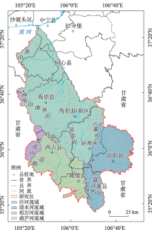
图1
研究区地理位置"

表1
生态重要性评价方法"
| 生态系统服务 | 权重 | 评估模型/方法 | 基本原理及计算公式 |
|---|---|---|---|
| 生境维持 | 0.417 | InVEST-Habitat Quality model | 式中:Qxj为土地利用类型j中栅格x的生境质量;Dxj为土地利用类型j中栅格x所受胁迫水平;k为半饱和常数,通常取Dxj最大值的一半;Hj为土地利用类型j的生境适合性;z为归一化常量[ |
| 产水服务 | 0.316 | InVEST-Water Yield model | 式中:Yjx为土地利用类型j中栅格x的年产水量(mm);Px为栅格单元x的年均降雨量;AETxj为土地利用类型j中栅格x的年平均蒸散发量;Rxj为土地利用类型j中栅格x的干燥指数,表示潜在蒸发量与降雨量的比值;ωx为修正植被年可利用水量与降水量的比值;k为植被系数,由植被叶面积指数计算[ |
| 土壤保持 | 0.146 | InVEST-Sediment Delivery Ratio model | 式中:SCx和SRx分别为栅格x的土壤保持量(t·hm-2·a-1)和泥沙持留量(t·hm-2·a-1);SEy为上坡栅格y产生的泥沙量(t·hm-2·a-1),Ex为栅格x的泥沙持留效率[ |
| 固碳服务 | 0.082 | CASA模型-NPP法 | 式中:NPP(x, t)为栅格x的植被在t时段内的净初级生产力(g C·m-2·a-1);APAR(x, t)为栅格x在t时段内植被所吸收的光和有效辐射;ξ(x, t)为栅格x的植被在t时段内的光能转化率[ |
| 粮食供给 | 0.038 | NDVI配比法 | 式中:Cropmn为第n个县第m个栅格的粮食供给服务(t·a-1);NDVIm为该栅格全年中的NDVI最大值;NDVIn为第n个县的NDVI全年最大值的和;Cropn为第n个县的粮食年产量(t·a-1)[ |
表2
生态阻力面构建"
| 阻力因子 | 权重 | 阻力值 | ||||||
|---|---|---|---|---|---|---|---|---|
| 1 | 10 | 30 | 50 | 70 | 90 | |||
| 自然环境因子 | 土地覆被类型 | 0.269 | 森林、湿地 | 灌丛、草地 | 农田 | 荒漠 | 其他 | 城镇 |
| 植被覆盖度/% | 0.172 | - | ≥70 | 50~70 | 30~50 | 10~30 | <10 | |
| 距离水体距离/km | 0.127 | - | <1 | 1~3 | 3~5 | 5~10 | ≥10 | |
| 干旱指数 | 0.090 | - | <0.45 | 0.45~0.58 | 0.58~0.66 | 0.66~0.71 | ≥0.71 | |
| 坡度/(°) | 0.056 | - | <6 | 6~15 | 15~25 | 25~45 | ≥45 | |
| 水土流失敏感性 | 0.036 | - | 一般敏感 | 较敏感 | 中度敏感 | 高度敏感 | 极敏感 | |
| 社会经济因子 | 距离居民点/km | 0.103 | - | ≥2 | 1~2 | 0.5~1 | 0.25~0.5 | <0.25 |
| 距离采矿/km | 0.073 | ≥15 | 10~15 | 5~10 | 2~5 | 1~2 | <10 | |
| 距离道路/km | 0.047 | ≥10 | 5~10 | 2~5 | 1~2 | 0.5~1 | <0.5 | |
| 夜间灯光因子 | 0.027 | <0.21 | 0.21~0.48 | 0.48~0.74 | 0.74~1.79 | ≥1.79 | ||
表3
生态系统服务极重要区面积构成"
| 生境质量 | 产水服务 | 土壤保持 | 固碳服务 | 粮食供给 | 综合评价 | |||||||||||
|---|---|---|---|---|---|---|---|---|---|---|---|---|---|---|---|---|
| 面积/km2 | 比重/% | 面积/km2 | 比重/% | 面积/km2 | 比重/% | 面积/km2 | 比重/% | 面积/km2 | 比重/% | 面积/km2 | 比重/% | |||||
| 4747.7 | 25.4 | 6121.3 | 32.8 | 1749.6 | 9.4 | 5183.0 | 27.7 | 5518.0 | 29.5 | 4473.8 | 23.9 | |||||
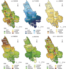
图2
生态重要性空间格局"

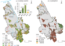
图3
生态源地空间格局"

表4
生态源地县域构成"
| 类型 | 生态源地 | |||||||||
|---|---|---|---|---|---|---|---|---|---|---|
| 泾源县 | 彭阳县 | 原州区 | 海原县 | 隆德县 | 西吉县 | 沙坡头区 | 中宁县 | 同心县 | 总计 | |
| 数量/个 | 2 | 25 | 10 | 18 | 9 | 8 | 12 | 8 | 4 | 96 |
| 面积/km2 | 1029.0 | 991.5 | 589.2 | 504.7 | 410.8 | 243.5 | 226.3 | 74.5 | 10.9 | 4080.3 |
| 百分比/% | 25.2 | 24.3 | 14.4 | 12.4 | 10.1 | 6.0 | 5.5 | 1.8 | 0.2 | 100.0 |
表5
生态源地重要性构成"
| 生态源地重要性 | 电流阈值 | 数量/个 | 比重/% | 面积/km2 | 比重/% |
|---|---|---|---|---|---|
| 一般源地 | 2.0~235.9 | 24 | 32.0 | 212.6 | 5.2 |
| 重要源地 | 235.9~394.1 | 25 | 33.3 | 611.1 | 15.0 |
| 核心源地 | 394.1~1380.0 | 26 | 34.7 | 3256.6 | 79.8 |
| 总计 | 75 | 100.0 | 4080.3 | 100.0 | |
表6
生态阻力面分区构成"
| 低值区 | 中值区 | 高值区 | 合计 | |
|---|---|---|---|---|
| 面积/km2 | 8259.7 | 6049.2 | 4371.3 | 18680.2 |
| 比重/% | 44.2 | 32.4 | 23.4 | 100.0 |
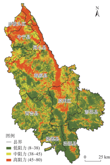
图4
生态阻力面阈值分区"

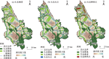
图5
生态廊道及夹点和障碍点空间格局"

表7
生态廊道及夹点和障碍点识别"
| 电流、电阻值 | 生态类型 | 阈值 | 类型 | 数量/个 | 比重/% | 面积、长度 | 比重/% |
|---|---|---|---|---|---|---|---|
| 电流值 | 生态廊道 | 2.0~80.8 | 一般廊道 | 45 | 32.6 | 579.0 km | 48.1 |
| 80.8~162.5 | 重要廊道 | 46 | 33.3 | 413.1 km | 34.3 | ||
| 162.5~616.0 | 关键廊道 | 47 | 34.1 | 211.6 km | 17.6 | ||
| 总计 | 138 | 100.0 | 1203.7 km | 100.0 | |||
| 电流值 | 生态夹点 | 0.02~0.27 | ≤1 km2夹点 | 455 | 83.2 | 37.6 km2 | 6.0 |
| 1~5 km2夹点 | 57 | 10.4 | 148.1 km2 | 23.6 | |||
| ≥5 km2 夹点 | 35 | 6.4 | 441.2 km2 | 70.4 | |||
| 总计 | 547 | 100.0 | 626.9 km2 | 100.0 | |||
| 电阻值 | 生态障碍点 | 36.2~92.7 | ≤1 km2 障碍点 | 146 | 67.3 | 31.7 km2 | 3.5 |
| 1~5 km2 障碍点 | 42 | 19.3 | 103.4 km2 | 11.6 | |||
| ≥5 km2 障碍点 | 29 | 13.4 | 758.8 km2 | 84.9 | |||
| 总计 | 217 | 100.0 | 893.9 km2 | 100.0 |
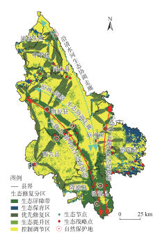
图6
生态安全格局构建及修复分区"

表8
生态安全格局构建及修复分区"
| 生态修复分区 | 格局类型 | 面积/km2 | 面积占比/% |
|---|---|---|---|
| 生态屏障带 | 核心源地 | 2852.8 | 15.3 |
| 关键廊道 | 395.9 | 2.1 | |
| 生态保育区 | 核心源地 | 417.7 | 2.2 |
| 其他源地 | 810.1 | 4.3 | |
| 修复提升区 | 优先修复区(其他生态廊道) | 3449.2 | 18.5 |
| 生态提升区(生态阻力低值区) | 3670.7 | 19.7 | |
| 控制调节区 | 生态阻力中值区 | 3929.3 | 21.0 |
| 生态阻力高值区 | 3154.5 | 16.9 | |
| 总计 | 18680.2 | 100.0 | |
| [1] | 王聪, 伍星, 傅伯杰, 等. 重点脆弱生态区生态恢复模式现状与发展方向[J]. 生态学报, 2019, 39(20): 7333-7343. |
| [Wang Cong, Wu Xing, Fu Bojie, et al. Ecological restoration in the key ecologically vulnerable regions: Current situation and development direction[J]. Acta Ecologica Sinica, 2019, 39(20): 7333-7343. ] | |
| [2] |
易行, 白彩全, 梁龙武, 等. 国土生态修复研究的演进脉络与前沿进展[J]. 自然资源学报, 2020, 35(1): 37-52.
doi: 10.31497/zrzyxb.20200105 |
|
[Yi Xing, Bai Caiquan, Liang Longwu, et al. The evolution and frontier development of land ecological restoration research[J]. Journal of Natural Resources, 2020, 35(1): 37-52. ]
doi: 10.31497/zrzyxb.20200105 |
|
| [3] |
彭建, 赵会娟, 刘焱序, 等. 区域生态安全格局构建研究进展与展望[J]. 地理研究, 2017, 36(3): 407-419.
doi: 10.11821/dlyj201703001 |
|
[Peng Jian, Zhao Huijuan, Liu Yanxu, et al. Research progress and prospect on regional ecological security pattern construction[J]. Geographical Research, 2017, 36(3): 407-419. ]
doi: 10.11821/dlyj201703001 |
|
| [4] |
陈昕, 彭建, 刘焱序, 等. 基于“重要性—敏感性—连通性”框架的云浮市生态安全格局构建[J]. 地理研究, 2017, 36(3): 471-484.
doi: 10.11821/dlyj201703006 |
|
[Chen Xin, Peng Jian, Liu Yanxu, et al. Constructing ecological security patterns in Yunfu City based on the framework of importance-sensitivity-connectivity[J]. Geographical Research, 2017, 36(3): 471-484. ]
doi: 10.11821/dlyj201703006 |
|
| [5] | 张亮, 岳文泽, 陈阳. 基于斑块复合属性特征的城市生态安全格局构建——以杭州市为例[J]. 生态学报, 2021, 41(11): 4632-4640. |
| [Zhang Liang, Yue Wenze, Chen Yang. Construction of urban ecological security pattern based on of patch composite characteristics: A case study of Hangzhou[J]. Acta Ecologica Sinica, 2021, 41(11): 4632-4640. ] | |
| [6] | 俞孔坚, 李海龙, 李迪华, 等. 国土尺度生态安全格局[J]. 生态学报, 2009, 29(10): 5163-5175. |
| [Yu Kongjian, Li Hailong, Li Dihua, et al. National scale ecological security pattern[J]. Acta Ecologica Sinica, 2009, 29(10): 5163-5175. ] | |
| [7] |
侯鹏, 王桥, 申文明, 等. 生态系统综合评估研究进展: 内涵、框架与挑战[J]. 地理研究, 2015, 34(10): 1809-1823.
doi: 10.11821/dlyj201510001 |
|
[Hou Peng, Wang Qiao, Shen Wenming, et al. Progress of integrated ecosystem assessment: Concept, framework and challenges[J]. Geographical Research, 2015, 34(10): 1809-1823. ]
doi: 10.11821/dlyj201510001 |
|
| [8] |
彭建, 李慧蕾, 刘焱序, 等. 雄安新区生态安全格局识别与优化策略[J]. 地理学报, 2018, 73(4): 701-710.
doi: 10.11821/dlxb201804009 |
|
[Peng Jian, Li Huilei, Liu Yanxu, et al. Identification and optimization of ecological security pattern in Xiong’an New Area[J]. Acta Geographica Sinica, 2018, 73(4): 701-710. ]
doi: 10.11821/dlxb201804009 |
|
| [9] |
韩宗伟, 焦胜, 胡亮, 等. 廊道与源地协调的国土空间生态安全格局构建[J]. 自然资源学报, 2019, 34(10): 2244-2256.
doi: 10.31497/zrzyxb.20191019 |
|
[Han Zongwei, Jiao Sheng, Hu Liang, et al. Construction of ecological security pattern based on coordination between corridors and sources in national territorial space[J]. Journal of Natural Resources, 2019, 34(10): 2244-2256. ]
doi: 10.31497/zrzyxb.20191019 |
|
| [10] |
赵文祯, 韩增林, 闫晓露, 等. 基于生态系统服务多情景权衡的生态安全格局构建——以大连市瓦房店为例[J]. 自然资源学报, 2020, 35(3): 546-562.
doi: 10.31497/zrzyxb.20200304 |
|
[Zhao Wenzhen, Han Zenglin, Yan Xiaolu, et al. Ecological security pattern construction based on multi-scenario trade-off of ecosystem services: A case study of Wafangdian, Dalian[J]. Journal of Natural Resources, 2020, 35(3): 546-562. ]
doi: 10.31497/zrzyxb.20200304 |
|
| [11] | 徐智超, 刘华民, 韩鹏, 等. 内蒙古生态安全时空演变特征及驱动力[J]. 生态学报, 2021, 41(11): 4354-4366. |
| [Xu Zhichao, Liu Huamin, Han Peng, et al. Analysis of the characteristics and driving forces of the temporal and spatial evolution of ecological security in Inner Mongolia[J]. Acta Ecologica Sinica, 2021, 41(11): 4354-4366. ] | |
| [12] | 吴金华, 刘思雨, 白帅. 基于景观生态安全的神木市生态廊道识别与优化[J]. 干旱区研究, 2021, 38(4): 1120-1127. |
| [Wu Jinhua, Liu Siyu, Bai Shuai. Identification and optimization of ecological corridors in Shenmu City based on landscape ecological security[J]. Arid Zone Research, 2021, 38(4): 1120-1127. ] | |
| [13] | 于成龙, 刘丹, 冯锐, 等. 基于最小累积阻力模型的东北地区生态安全格局构建[J]. 生态学报, 2021, 41(1): 290-301. |
| [Yu Chenglong, Liu Dan, Feng Rui, et al. Construction of ecological security pattern in Northeast China based on MCR model[J]. Acta Ecologica Sinica, 2021, 41(1): 290-301. ] | |
| [14] | 毛诚瑞, 代力民, 齐麟, 等. 基于生态系统服务的流域生态安全格局构建——以辽宁省辽河流域为例[J]. 生态学报, 2020, 40(18): 6486-6494. |
| [Mao Chengrui, Dai Limin, Qi Lin, et al. Constructing ecological security pattern based on ecosystem services: A case study in Liaohe River Basin, Liaoning Province, China[J]. Acta Ecologica Sinica, 2020, 40(18): 6486-6494. ] | |
| [15] | 付凤杰, 刘珍环, 刘海. 基于生态安全格局的国土空间生态修复关键区域识别——以贺州市为例[J]. 生态学报, 2021, 41(9): 3406-3414. |
| [Fu Fengjie, Liu Zhenhuan, Liu Hai. Identifying key areas of ecosystem restoration for territorial space based on ecological security pattern: A case study in Hezhou City[J]. Acta Ecologica Sinica, 2021, 41(9): 3406-3414. ] | |
| [16] | 吴健生, 罗可雨, 马洪坤, 等. 基于生态系统服务与引力模型的珠三角生态安全与修复格局研究[J]. 生态学报, 2020, 40(23): 8417-8429. |
| [Wu Jiansheng, Luo Keyu, Ma Hongkun, et al. Ecological security and restoration pattern of Pearl River Delta, based on ecosystem service and gravity model[J]. Acta Ecologica Sinica, 2020, 40(23): 8417-8429. ] | |
| [17] |
McRae B H, Beier P. Circuit theory predicts gene flow in plant and animal populations[J]. Proceedings of the National Academy of Sciences of the United States of America, 2007, 104(50): 19885-19890.
doi: 10.1073/pnas.0706568104 pmid: 18056641 |
| [18] |
Walpole A A, Bowman J, Murray D L, et al. Functional connectivity of lynx at their southern range periphery in Ontario, Canada[J]. Landscape Ecology, 2012, 27(5): 761-773.
doi: 10.1007/s10980-012-9728-1 |
| [19] | 苏冲, 董建权, 马志刚, 等. 基于生态安全格局的山水林田湖草生态保护修复优先区识别——以四川省华蓥山区为例[J]. 生态学报, 2019, 39(23): 8948-8956. |
| [Su Chong, Dong Jianquan, Ma Zhigang, et al. Identifying priority areas for ecological protection and restoration of mountains-rivers-forests-farmlands-lakes-grasslands based on ecological security patterns: A case study in Huaying Mountain, Sichuan Province[J]. Acta Ecologica Sinica, 2019, 39(23): 8948-8956. ] | |
| [20] | 林勇, 樊景凤, 温泉, 等. 生态红线划分的理论和技术[J]. 生态学报, 2016, 36(5): 1244-1252. |
| [Lin Yong, Fan Jingfeng, Wen Quan, et al. Primary exploration of ecological theories and technologies for delineation of ecological redline zones[J]. Acta Ecologica Sinica, 2016, 36(5): 1244-1252. ] | |
| [21] |
方莹, 王静, 黄隆杨, 等. 基于生态安全格局的国土空间生态保护修复关键区域诊断与识别——以烟台市为例[J]. 自然资源学报, 2020, 35(1): 190-203.
doi: 10.31497/zrzyxb.20200116 |
|
[Fang Ying, Wang Jing, Huang Longyang, et al. Determining and identifying key areas of ecosystem preservation and restoration for territorial spatial planning based on ecological security patterns: A case study of Yantai City[J]. Journal of Natural Resources, 2020, 35(1): 190-203. ]
doi: 10.31497/zrzyxb.20200116 |
|
| [22] | 胡胜, 曹明明, 李婷, 等. 基于AHP和GIS的陕西省地震次生地质灾害危险性评价[J]. 第四纪研究, 2014, 34(2): 336-345. |
| [Hu Sheng, Cao Mingming, Li Ting, et al. Danger assessment of earthouake-induced geological disasters in Shaanxi Provinces based on AHP and GIS[J]. Quaternary Sciences, 2014, 34(2): 336-345. ] | |
| [23] | 包玉斌. 基于InVEST模型的宁夏生物多样性保护优先区域生境评估与生态廊道构建[J]. 宁夏大学学报(自然科学版), 2022, 43(3): 318-324. |
| [Bao Yubin. Habitat evaluation and ecological corridor construction of priority area for biodiversity conservation in Ningxia based on InVEST model[J]. Journal of Ningxia University (Natural Science Edition), 2022, 43(3): 318-324. ] | |
| [24] | 包玉斌. 基于InVEST模型的陕北黄土高原生态服务功能时空变化研究[D]. 西安: 西北大学, 2015. |
| [Bao Yubin. Temporal and Spatial Change of Ecological Services on Loess Plateau of Shaanxi by InVEST model[D]. Xi’an: Northwest University, 2015. ] | |
| [25] |
包玉斌, 李婷, 柳辉, 等. 基于InVEST模型的陕北黄土高原水源涵养功能时空变化[J]. 地理研究, 2016, 35(4): 664-676.
doi: 10.11821/dlyj201604006 |
|
[Bao Yubin, Li Ting, Liu Hui, et al. Spatial and temporal changes of water conservation of Loess Plateau in northern Shaanxi Province by InVEST model[J]. Geographical Research 2016, 35(4): 664-676. ]
doi: 10.11821/dlyj201604006 |
|
| [26] | 包玉斌, 刘康, 李婷, 等. 基于InVEST模型的土地利用变化对生境的影响——以陕西省黄河湿地自然保护区为例[J]. 干旱区研究, 2015, 32(3): 622-629. |
| [Bao Yubin, Liu Kang, Li Ting, et al. Effects of land use change on habitat based on InVEST model: Taking Yellow River Wetland Nature Reserve in Shaanxi Province as an example[J]. Arid Zone Research, 2015, 32(3): 622-629. ] | |
| [27] | 王晓玉, 冯喆, 吴克宁, 等. 基于生态安全格局的山水林田湖草生态保护与修复[J]. 生态学报, 2019, 39(23): 8725-8732. |
| [Wang Xiaoyu, Feng Zhe, Wu Kening, et al. Eeological conservation and restoration of life community theory based on the construction of ecological security pattern[J]. Acta Ecologica Sinica, 2019, 39(23): 8725-8732. ] | |
| [28] | 高梦雯, 胡业翠, 李向, 等. 基于生态系统服务重要性和环境敏感性的喀斯特山区生态安全格局构建——以广西河池为例[J]. 生态学报, 2021, 41(7): 2596-2608. |
| [Gao Mengwen, Hu Yecui, Li Xiang, et al. Construction of ecological security pattern based on the importance of ecosystem services and environmental sensitivity in karst mountainous areas: A case study in Hechi, Guangxi[J]. Acta Ecologica Sinica, 2021, 41(7): 2596-2608. ] | |
| [29] | McRae B H, Kavanagh D M. Linkage Mapper Connectivity Analysis Software and User Guide[EB/OL]. https://circuitscape.org/linkagemapper , 2021-07-01. |
| [30] | McRae B H. Barrier Mapper Connectivity Analysis Software and User Guide[EB/OL]. https://circuitscape.org/linkagemapper/ , 2021-07-01. |
| [31] | McRae B H. Centrality Mapper Connectivity Analysis Software and User Guide[EB/OL]. https://circuitscape.org/linkagemapper , 2021-07-01. |
| [1] | 李可璇, 张蕾, 李豪, 张恩月, 李育桢, 宋彩云, 刘庚. 基于MSPA模型和电路理论的晋西北国土空间生态修复关键区域识别[J]. 干旱区研究, 2024, 41(9): 1593-1604. |
| [2] | 吴朝巧, 林菲, 牛俊杰, 耿甜伟. 山西中部城市群生态系统服务对土地利用格局变化的响应[J]. 干旱区研究, 2024, 41(7): 1153-1166. |
| [3] | 李冰洁, 范志韬, 曲芷程, 姚顺予, 宿夏姝, 刘东伟, 王立新. 基于InVEST-PLUS模型的黄河流域内蒙古段生态系统碳储量评价及预测[J]. 干旱区研究, 2024, 41(7): 1217-1227. |
| [4] | 张顺鑫, 吴子豪, 闫庆武, 李桂娥, 牟守国. 基于PLUS-InVEST模型的天山北坡生态系统碳储量时空变化与预测[J]. 干旱区研究, 2024, 41(7): 1228-1237. |
| [5] | 高雅玉, 宋玉, 赵廷红, 高金芳, 何文博, 李泽霞. 马莲河下游产水量时空演变特征[J]. 干旱区研究, 2024, 41(5): 776-787. |
| [6] | 刘如龙, 赵媛媛, 陈国清, 迟文峰, 刘正佳. 内蒙古黄河流域1990—2020年生境质量评估[J]. 干旱区研究, 2024, 41(4): 674-683. |
| [7] | 李佳珂, 邵战林. 基于PLUS和InVEST模型的乌鲁木齐市碳储量时空演变与预测[J]. 干旱区研究, 2024, 41(3): 499-508. |
| [8] | 严莉, 曹广超, 康利刚, 刘梦琳, 叶得力. 基于InVEST模型的共和县生境质量时空变化及驱动因素[J]. 干旱区研究, 2024, 41(2): 314-325. |
| [9] | 申草,任宗萍,李鹏,王凯博,鲁克新,任正龑,魏小燕. 宁夏水土保持生态补偿优先区识别[J]. 干旱区研究, 2023, 40(9): 1527-1536. |
| [10] | 张晓敏, 张东梅, 张伟. 人类活动对额尔齐斯河流域碳储量的影响[J]. 干旱区研究, 2023, 40(8): 1333-1345. |
| [11] | 马思敏, 舒志亮, 常倬林, 周楠, 刘士军. 宁夏六盘山区地面雨滴谱特征统计分析[J]. 干旱区研究, 2023, 40(8): 1203-1214. |
| [12] | 石建周, 刘贤德, 田青, 于澎涛, 王彦辉. 六盘山半干旱区华北落叶松林坡面土壤含水量的降雨响应[J]. 干旱区研究, 2023, 40(4): 594-604. |
| [13] | 王鹏, 秦思彤, 胡慧蓉. 近30 a拉萨河流域土地利用变化和生境质量的时空演变特征[J]. 干旱区研究, 2023, 40(3): 492-503. |
| [14] | 陈实, 黄银兰, 金云翔. 退耕还林(草)工程实施前后黄河中游生境质量时空变化分析[J]. 干旱区研究, 2023, 40(3): 456-468. |
| [15] | 雷馨, 海新权. 祁连山地区土地利用变化对碳储量的影响及经济价值估算[J]. 干旱区研究, 2023, 40(11): 1845-1854. |
|
||