干旱区研究 ›› 2023, Vol. 40 ›› Issue (4): 563-572.doi: 10.13866/j.azr.2023.04.05 cstr: 32277.14.AZR.20230405
吕锦心1,2( ),梁康1(),刘昌明1,张仪辉1,2,刘璐1,2
收稿日期:2022-03-22
修回日期:2022-12-24
出版日期:2023-04-15
发布日期:2023-04-28
作者简介:吕锦心(1996-),女,硕士研究生,主要从事干旱区水文水资源研究. E-mail: 基金资助:
LYU Jinxin1,2(),LIANG Kang1(),LIU Changming1,ZHANG Yihui1,2,LIU Lu1,2
Received:2022-03-22
Revised:2022-12-24
Published:2023-04-15
Online:2023-04-28
摘要:
无定河流域是黄土高原生态恢复工程实施的重点区,探究其土地覆被的空间分异机制及相关水碳变量的变化特征,对支撑区域水土资源保护与规划以及服务区域生态文明建设等工作具有重要作用。本文使用线性倾向法、Mann-Kendall趋势检验、Pettitt突变检验、地理探测器等方法分析无定河流域土地覆被时空变化特征及空间分异驱动因素,并从地-水-碳耦合的角度探析流域总初级生产力(GPP)、实际蒸散发(ET)和水分利用效率(WUE)等关键水碳变量的变化特征。研究表明:(1) 1990—2019年期间,流域整体草地、林地、建设用地显著增加,耕地、荒地显著减少,其中林草面积增加区域主要集中在流域下游及无定河沿岸地区;(2) 人口密度、降水、气温等对流域土地覆被空间格局具有重要影响,整体而言社会经济因素的影响大于自然因素,但以降水、气温为代表的自然因素的影响在增强;(3) 流域水碳变量的变化与土地覆被变化具有较好的对应关系,空间上,以耕地、林地、草地为主要覆被的流域东南部的GPP、ET、WUE相对偏高,以草地、荒地为主要覆被的流域西北部的GPP、ET、WUE相对偏低,时间上,2001—2019年间,流域整体GPP、ET、WUE均呈增加趋势,其中GPP、WUE在流域绝大部分区域均显著增加,而ET主要在流域中下游地区显著增加。在退耕还林还草生态恢复工程的实施与气候变化背景下,无定河流域林草得到恢复,生态环境转好。
吕锦心, 梁康, 刘昌明, 张仪辉, 刘璐. 无定河流域土地覆被空间分异机制及相关水碳变量变化[J]. 干旱区研究, 2023, 40(4): 563-572.
LYU Jinxin, LIANG Kang, LIU Changming, ZHANG Yihui, LIU Lu. Spatial differentiation mechanism of land cover and related changes in water-carbon variables in Wuding River Basin[J]. Arid Zone Research, 2023, 40(4): 563-572.
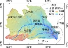
图1
无定河流域地理位置及高程"

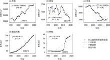
图2
1990—2019年无定河流域各土地覆被类型面积变化"

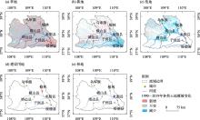
图3
无定河流域1990—2019年土地覆被类型变化情况"

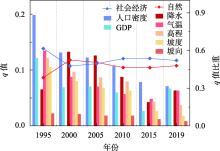
图4
土地覆被空间分异因子探测结果"

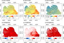
图5
2001—2019年无定河流域GPP、ET、WUE的变化"


图6
2001—2019年无定河流域整体及不同土地覆被类型的GPP、ET、WUE变化"

| [1] |
Turner B L, Lambin E F, Reenberg A. The emergence of land change science for global environmental change and sustainability[J]. Proceedings of the National Academy of Sciences, 2007, 104(52): 20666-20671.
doi: 10.1073/pnas.0704119104 |
| [2] |
Sterling S M, Ducharne A, Polcher J. The impact of global land-cover change on the terrestrial water cycle[J]. Nature Climate Change, 2013, 3(4): 385-390.
doi: 10.1038/nclimate1690 |
| [3] |
Rindfuss R R, Entwisle B, Walsh S J, et al. Land use change: complexity and comparisons[J]. Journal of Land Use Science, 2008, 3(1): 1-10.
doi: 10.1080/17474230802047955 pmid: 20354590 |
| [4] |
Liu X, Liang X, Li X, et al. A future land use simulation model (FLUS) for simulating multiple land use scenarios by coupling human and natural effects[J]. Landscape and Urban Planning, 2017, 168: 94-116.
doi: 10.1016/j.landurbplan.2017.09.019 |
| [5] |
Li Y, Piao S, Li L Z, et al. Divergent hydrological response to large-scale afforestation and vegetation greening in China[J]. Science Advances, 2018, 4(5): 4182.
doi: 10.1126/sciadv.aar4182 pmid: 29750196 |
| [6] | 刘婉如, 陈春波, 罗格平, 等. 巴尔喀什湖流域土地利用/覆被变化过程与趋势[J]. 干旱区研究, 2021, 38(5): 1452-1463. |
| [Liu Wanru, Chen Chunbo, Luo Geping, et al. Change processes and trends of land use/cover in the Balkhash Lake basin[J]. Arid Zone Research, 2021, 38(5): 1452-1463.] | |
| [7] |
Ren Y J, Lyu Y H, Fu B J, et al. Driving factors of land change in China’s Loess Plateau: Quantification using geographically weighted regression and management implications[J]. Remote Sensing, 2020, 12(3): 453.
doi: 10.3390/rs12030453 |
| [8] | Gohain K J, Mohammad P, Goswami A. Assessing the impact of land use land cover changes on land surface temperature over Pune city, India[J]. Quaternary International, 2021, 575: 259-269. |
| [9] |
Anand V, Oinam B. Future land use land cover prediction with special emphasis on urbanization and wetlands[J]. Remote Sensing Letters, 2020, 11(3): 225-234.
doi: 10.1080/2150704X.2019.1704304 |
| [10] | 王永洵, 王亚飞, 张静文, 等. 海岸带土地利用转型及其生态环境效应——以福建海岸带为例[J]. 环境科学学报, 2021, 41(10): 3927-3937. |
| [Wang Yongxun, Wang Yafei, Zhang Jingwen, et al. Land use transition in coastal zone and its eco-environmental effects: Taking Fujian coastal zone as an example[J]. Acta Scientiae Circumstantiae, 2021, 41(10): 3927-3937.] | |
| [11] |
Chen Y, Wang K, Lin Y, et al. Balancing green and grain trade[J]. Nature Geoscience, 2015, 8(10): 739-741.
doi: 10.1038/ngeo2544 |
| [12] | 李婷, 吕一河, 任艳姣, 等. 黄土高原植被恢复成效及影响因素[J]. 生态学报, 2020, 40(23): 8593-8605. |
| [Li Ting, Lyu Yihe, Ren Yanjiao, et al. Gauging the effectiveness of vegetation restoration and the influence factors in the Loess Plateau[J]. Acta Ecologica Sinica, 2020, 40(23): 8593-8605.] | |
| [13] | 李宗善, 杨磊, 王国梁, 等. 黄土高原水土流失治理现状、问题及对策[J]. 生态学报, 2019, 39(20): 7398-7409. |
| [Li Zongshan, Yang Lei, Wang Guoliang, et al. The management of soil and water conservation in the Loess Plateau of China: Present situations, problems, and counter-solutions[J]. Acta Ecologica Sinica, 2019, 39(20): 7398-7409.] | |
| [14] |
佟彪, 党安荣, 周宏宇. 无定河流域城镇聚落的历史演变与人地耦合[J]. 自然资源学报, 2021, 36(1): 38-54.
doi: 10.31497/zrzyxb.20210103 |
|
[Tong Biao, Dang Anrong, Zhou Hongyu. The historical evolution of urban settlements and man-land coupling in Wuding River Basin[J]. Journal of Natural Resources, 2021, 36(1): 38-54.]
doi: 10.31497/zrzyxb.20210103 |
|
| [15] | 王计平, 程复, 汪亚峰, 等. 生态恢复背景下无定河流域土地利用时空变化[J]. 水土保持通报, 2014, 34(5): 237-243. |
| [Wang Jiping, Cheng Fu, Wang Yafeng, et al. Spatial-temporal changes of land use in wuding river basin under ecological restoration[J]. Bulletin of Soil and Water Conservation, 2014, 34(5): 237-243.] | |
| [16] |
张冉, 王义民, 畅建霞, 等. 基于水资源分区的黄河流域土地利用变化对人类活动的响应[J]. 自然资源学报, 2019, 34(2): 274-287.
doi: 10.31497/zrzyxb.20190205 |
|
[Zhang Ran, Wang Yimin, Chang Jianxia, et al. Response of land use change to human activities in the Yellow River Basin based on water resources division[J]. Journal of Natural Resources, 2019, 34(2): 274-287.]
doi: 10.31497/zrzyxb.20190205 |
|
| [17] | 何航, 张勃, 候启, 等. 1982—2015年中国北方生长季NDVI变化及其对气温极值的响应[J]. 干旱区研究, 2020, 37(1): 244-253. |
| [He Hang, Zhang Bo, Hou Qi, et al. Spatio-temporal change of NDVI and its response to extreme temperature indices in North China from 1982 to 2015[J]. Arid Zone Research, 2020, 37(1): 244-253.] | |
| [18] |
Tian X, Zhao G, Mu X, et al. Hydrologic alteration and possible underlying causes in the Wuding River, China[J]. Science of the Total Environment, 2019, 693: 133556.
doi: 10.1016/j.scitotenv.2019.07.362 |
| [19] |
宁怡楠, 杨晓楠, 孙文义, 等. 黄河中游河龙区间径流量变化趋势及其归因[J]. 自然资源学报, 2021, 36(1): 256-269.
doi: 10.31497/zrzyxb.20210117 |
|
[Ning Yinan, Yang Xiaonan, Sun Wenyi, et al. The trend of runoff change and its attribution in the middle reaches of the Yellow River[J]. Journal of Natural Resources, 2021, 36(1): 256-269.]
doi: 10.31497/zrzyxb.20210117 |
|
| [20] | 蒋凯鑫, 于坤霞, 曹文洪, 等. 黄土高原典型流域水沙变化归因对比分析[J]. 农业工程学报, 2020, 36(4): 143-149. |
| [Jiang Kaixin, Yu Kunxia, Cao Wenhong, et al. Attributional comparative analysis of runoff and sediment change in typical basin of Loess Plateau[J]. Chinese Journal of Agricultural Engineering, 2020, 36(4): 143-149.] | |
| [21] | 陶帅, 邝婷婷, 彭文甫, 等. 2000—2015年长江上游NDVI时空变化及驱动力——以宜宾市为例[J]. 生态学报, 2020, 40(14): 5029-5043. |
| [Tao Shuai, Kuang Tingting, Peng Wenfu, et al. Analyzing the spatio-temporal variation and drivers of NDVI in upper reaches of the Yangtze River from 2000 to 2015: A case study of Yibin City[J]. Acta Ecologica Sinica, 2020, 40(14): 5029-5043.] | |
| [22] | 纪秋磊, 梁伟, 傅伯杰, 等. 基于Google Earth Engine与复杂网络的黄河流域土地利用/覆被变化分析[J]. 生态学报, 2022, 42(6): 2122-2135. |
| [Ji Qiulei, Liang Wei, Fu Bojie, et al. Land use/cover change in the Yellow River Basin based on Google Earth Engine and complex network[J]. Acta Ecologica Sinica, 2022, 42(6): 2122-2135.] | |
| [23] | 闫国振, 张征, 梁康, 等. 鄂尔多斯高原泊江海子流域土地利用动态变化及驱动因素分析[J]. 中国生态农业学报, 2017, 25(11): 1693-1706. |
| [Yan Guozhen, Zhang Zheng, Liang Kang, et al. Characteristics and driving factors of land use change in the Bojiang Lake Basin in Ordos Plateau, China[J]. Chinese Journal of Eco-Agriculture, 2017, 25(11): 1693-1706.] | |
| [24] |
臧玉珠, 刘彦随, 杨园园. 山区县域土地利用格局变化及其地形梯度效应——以井冈山市为例[J]. 自然资源学报, 2019, 34(7): 1391-1404.
doi: 10.31497/zrzyxb.20190704 |
|
[Zang Yuzhu, Liu Yansui, Yang Yuanyuan. Land use pattern change and its topographic gradient effect in the mountainous areas: A case study of Jinggangshan city[J]. Journal of Natural Resources, 2019, 34(7): 1391-1404.]
doi: 10.31497/zrzyxb.20190704 |
|
| [25] |
于元赫, 李子君, 林锦阔, 等. 沂河流域土地利用时空变化图谱特征分析[J]. 自然资源学报, 2019, 34(5): 975-988.
doi: 10.31497/zrzyxb.20190506 |
|
[Yu Yuanhe, Li Zijun, Lin Jinkuo, et al. TUPU characteristics of spatiotemporal variation for the land use in the Yihe River Basin[J]. Journal of Natural Resources, 2019, 34(5): 975-988.]
doi: 10.31497/zrzyxb.20190506 |
|
| [26] |
何春阳, 张金茜, 刘志锋, 等. 1990—2018年土地利用/覆盖变化研究的特征和进展[J]. 地理学报, 2021, 76(11): 2730-2748.
doi: 10.11821/dlxb202111010 |
|
[He Chunyang, Zhang Jinqian, Liu Zhifeng, et al. Characteristics and progress of land use/cover change research during 1990-2018[J]. Acta Geographica Sinica, 2021, 76(11): 2730-2748.]
doi: 10.11821/dlxb202111010 |
|
| [27] |
Berihun M L, Tsunekawa A, Haregeweyn N, et al. Exploring land use/land cover changes, drivers and their implications in contrasting agro-ecological environments of Ethiopia[J]. Land Use Policy, 2019, 87: 104052.
doi: 10.1016/j.landusepol.2019.104052 |
| [28] |
高江波, 焦珂伟, 吴绍洪. 1982—2013年中国植被NDVI空间异质性的气候影响分析[J]. 地理学报, 2019, 74(3): 534-543.
doi: 10.11821/dlxb201903010 |
|
[Gao Jiangbo, Jiao Kewei, Wu Shaohong. Revealing the climatic impacts on spatial heterogeneity of NDVI in China during 1982-2013[J]. Acta Geographica Sinica, 2019, 74(3): 534-543.]
doi: 10.11821/dlxb201903010 |
|
| [29] |
Arowolo A O, Deng X. Land use/land cover change and statistical modelling of cultivated land change drivers in Nigeria[J]. Regional environmental change, 2018, 18(1): 247-259.
doi: 10.1007/s10113-017-1186-5 |
| [30] |
王劲峰, 徐成东. 地理探测器:原理与展望[J]. 地理学报, 2017, 72(1): 116-134.
doi: 10.11821/dlxb201701010 |
|
[Wang Jinfeng, Xu Chengdong. Geodetector: Principle and prospective[J]. Acta Geographica Sinica, 2017, 72(1): 116-134.]
doi: 10.11821/dlxb201701010 |
|
| [31] | 马晓妮, 任宗萍, 谢梦瑶, 等. 基于地理探测器的砒砂岩区植被覆盖度环境驱动因子量化分析[J]. 生态学报, 2022, 42(8): 3389-3399. |
| [Ma Xiaoni, Ren Zongping, Xie Mengyao, et al. Quantitative analysis of environmental driving factors of vegetation coverage in the Pisha sandstone area based on geodetector[J]. Acta Ecologica Sinica, 2022, 42(8): 3389-3399.] | |
| [32] |
韩美, 孔祥伦, 李云龙, 等. 黄河三角洲“三生”用地转型的生态环境效应及其空间分异机制[J]. 地理科学, 2021, 41(6): 1009-1018.
doi: 10.13249/j.cnki.sgs.2021.06.010 |
|
[Han Mei, Kong Xianglun, Li Yunlong, et al. Eco-environmental effects and its spatial heterogeneity of ‘ecological-production-living’ land use transformation in the Yellow River Delta[J]. Scientia Geographica Sinica, 2021, 41(6): 1009-1018.]
doi: 10.13249/j.cnki.sgs.2021.06.010 |
|
| [33] | 韩海青, 王旭红, 牛林芝, 等. 1992—2015年中亚五国LUCC特征及耕地驱动力研究[J]. 中国生态农业学报, 2021, 29(2): 325-339. |
| [Han Haiqing, Wang Xuhong, Niu Linzhi, et al. The land-use and land-cover change characteristics and driving forces of cultivated land in Central Asian countries from 1992 to 2015[J]. Chinese Journal of Eco-Agriculture, 2021, 29(2): 325-339.] | |
| [34] |
Zhang K, Kimball J S, Nemani R R, et al. Vegetation greening and climate change promote multidecadal rises of global land evapotranspiration[J]. Scientific Reports, 2015, 5: 15956.
doi: 10.1038/srep15956 pmid: 26514110 |
| [35] | 姚佳, 陈启慧, 李琼芳, 等. 伊犁河—巴尔喀什湖流域实际蒸散发时空变化特征及其环境影响因子[J]. 干旱区研究, 2022, 39(5): 1564-1575. |
| [Yao Jia, Chen Qihui, Li Qiongfang, et al. Spatial and temporal variability of evapotranspiration and its environmental influencing factors in lli River-Balkhash Lake Basin[J]. Arid Zone Research, 2022, 39(5): 1564-1575.] | |
| [36] |
Monteith J L. Solar radiation and productivity in tropical ecosystems[J]. Journal of Applied Ecology, 1972, 9(3): 747-766.
doi: 10.2307/2401901 |
| [37] |
Guan X, Chen J M, Shen H, et al. Comparison of big-leaf and two-leaf light use efficiency models for GPP simulation after considering a radiation scalar[J]. Agricultural and Forest Meteorology, 2022, 313: 108761.
doi: 10.1016/j.agrformet.2021.108761 |
| [38] | 张世喆, 朱秀芳, 刘婷婷, 等. 气候变化下中国不同植被区GPP对干旱的响应分析[J]. 生态学报, 2022, 42(8): 3429-3440. |
| [Zhang Shizhe, Zhu Xiufang, Liu Tingting, et al. Response of gross primary production to drought under climate change in different vegetation regions of China[J]. Acta Ecologica Sinica, 2022, 42(8): 3429-3440.] | |
| [39] |
To A, Inatomi M. Water-use efficiency of the terrestrial biosphere: A model analysis focusing on interactions between the global carbon and water cycles[J]. Journal of Hydrometeorology, 2012, 13(2): 681-694.
doi: 10.1175/JHM-D-10-05034.1 |
| [40] | 吴方涛, 曹生奎, 曹广超, 等. 高寒湿地生态系统水分利用效率研究[J]. 干旱区研究, 2018, 35(2): 306-314. |
| [Wu Fangtao, Cao Shengkui, Cao Guangchao, et al. Water use Efficiency of Alpine Wetland Ecosystem[J]. Arid Zone Research, 2018, 35(2): 306-314.] | |
| [41] |
张永强, 孔冬冬, 张选泽, 等. 2003—2017年植被变化对全球陆面蒸散发的影响[J]. 地理学报, 2021, 76(3): 584-594.
doi: 10.11821/dlxb202103007 |
|
[Zhang Yongqiang, Kong Dongdong, Zhang Xuanze, et al. Impacts of vegetation changes on global evapotranspiration in the period 2003-2017[J]. Acta Geographica Sinica, 2021, 76(3): 584-594.]
doi: 10.11821/dlxb202103007 |
|
| [42] |
李艳忠, 刘昌明, 刘小莽, 等. 植被恢复工程对黄河中游土地利用/覆被变化的影响[J]. 自然资源学报, 2016, 31(12): 2005-2020.
doi: 10.11849/zrzyxb.20160073 |
|
[Li Yanzhong, Liu Changming, Liu Xiaomang, et al. Impact of the grain for green project on the land use/cover change in the middle Yellow River[J]. Journal of Natural Resources, 2016, 31(12): 2005-2020.]
doi: 10.11849/zrzyxb.20160073 |
|
| [43] | 叶许春, 杨晓霞, 刘福红, 等. 长江流域陆地植被总初级生产力时空变化特征及其气候驱动因子[J]. 生态学报, 2021, 41(17): 6949-6959. |
| [Ye Xuchun, Yang Xiaoxia, Liu Fuhong, et al. Spatio temporal variations of land vegetation gross primary production in the Yangtze River Basin and correlation with meteorological factors[J]. Acta Ecologica Sinica, 2021, 41(17): 6949-6959.] | |
| [44] | Li C, Zhang Y, Shen Y, et al. LUCC-driven changes in gross primary production and actual evapotranspiration in northern China[J]. Journal of Geophysical Research: Atmospheres, 2020, 125(6): e2019JD031705. |
| [45] |
佟彪, 党安荣, 周宏宇. 无定河流域城镇聚落的历史演变与人地耦合[J]. 自然资源学报, 2021, 36(1): 38-54.
doi: 10.31497/zrzyxb.20210103 |
|
[Tong Biao, Dang Anrong, Zhou Hongyu. The historical evolution of urban settlements and man-land coupling in Wuding River Basin[J]. Journal of Natural Resources, 2021, 36(1): 38-54.]
doi: 10.31497/zrzyxb.20210103 |
|
| [46] |
Xu Y, Yu L, Peng D, et al. Annual 30-m land use/land cover maps of China for 1980-2015 from the integration of AVHRR, MODIS and Landsat data using the BFAST algorithm[J]. Science China Earth Science, 2020, 63(9): 1390-1407.
doi: 10.1007/s11430-019-9606-4 |
| [47] | 徐新良. 中国GDP空间分布公里网格数据集[DB/OL]. 中国科学院资源环境科学数据中心数据注册与出版系统, 2017. |
| [Xu Xinliang. Kilometer Grid Dataset of Spatial Distribution of China’s GDP[DB/OL]. Data Registration and Publishing System of Resources and Environment Science and Data Center, Chinese Academy of Sciences, 2017.] | |
| [48] | 徐新良. 中国人口空间分布公里网格数据集[DB/OL]. 中国科学院资源环境科学数据中心数据注册与出版系统, 2017. |
| [Xu Xinliang. Kilometer Grid Dataset of Population Spatial Distribution in China[DB/OL]. Data Registration and Publishing System of Resources and Environment Science and Data Center, Chinese Academy of Sciences, 2017.] | |
| [49] | 张永强, 何韶阳. 中国区域PML-V2陆地蒸散发与总初级生产力数据集(2000.02.26-2020.12.31)[DB/OL]. 国家青藏高原科学数据中心, 2022. |
| [Zhang Yongqiang, He Shaoyang. PML-V2(China): Evapotranspiration and Gross Primary Production (2000. 02.26-2020.12.31)[DB/OL]. National Tibetan Plateau Data Center, 2022.] | |
| [50] | 魏凤英. 现代气候统计诊断与预测技术[M]. 北京: 气象出版社, 1999. |
| [Wei Fengying. Modern Climate Statistical Diagnosis and Prediction Technology[M]. Beijing: Meteorological Press, 1999.] | |
| [51] |
Mann H B. Nonparametric tests against trend[J]. Econometrica: Journal of the Econometric Society, 1945, 13(3): 245-259.
doi: 10.2307/1907187 |
| [52] | Kendall M G. Rank correlation methods[J]. British Journal of Psychology, 1990, 25(1): 86-91. |
| [53] | Pettitt A N. A Non-parametric approach to the change-point problem[J]. Journal of the Royal Statistical Society: Series C (Applied Statistics), 1978, 28(2): 126-135. |
| [54] | 徐成东, 王劲峰, 邢丁凡. 一种基于模拟退火的地理探测器最优离散化方法: CN108959192A[P]. 2018. |
| [Xu Chengdong, Wang Jinfeng, Xing Dingfan. An Optimal Discretization Method for Geographic Detectors Based on Simulated Annealing: CN108959192A[P]. 2018.] | |
| [55] | 朱永华, 罗平平, 郭倩, 等. 毛乌素沙地暖湿化特征分析及其对植被变化的影响[J]. 水土保持学报, 2022, 36(5): 160-172, 180. |
| [Zhu Yonghua, Luo Pingping, Guo Qian, et al. Analysis of warming and humidifying characteristics of Mu Us Sandy Land and its influence on vegetation change[J]. Journal of Soil and Water Conservation, 2022, 36(5): 160-172, 180.] | |
| [56] | 孙福宝. 基于Budyko水热耦合平衡假设的流域蒸散发研究[D]. 北京: 清华大学, 2007. |
| [Sun Fubao. Study on Watershed Evapotranspiration Based on the Budyko Hypothesis[D]. Beijing: Tsinghua University, 2007.] |
| [1] | 邱春霞, 刘晓宏, 李豆, 张佳淼, 李朋飞. 机载LiDAR和模糊推理系统在黄土高原土壤侵蚀监测中的应用[J]. 干旱区研究, 2024, 41(8): 1331-1342. |
| [2] | 侯嘉烨, 李建华, 王佳蓉, 马海涛, 强泽楷, 樊新刚. 基于SA-RSEI模型的盐池县生态质量演变研究[J]. 干旱区研究, 2024, 41(6): 1045-1058. |
| [3] | 姚小晨, 高凡, 韩方红, 何兵. 2000—2020年阿克苏河流域土地利用强度变化及其对蒸散发的影响[J]. 干旱区研究, 2024, 41(6): 951-963. |
| [4] | 唐可欣, 郭建斌, 何亮, 陈林, 万龙. 中国旱区GPP时空演变特征及影响因素研究[J]. 干旱区研究, 2024, 41(6): 964-973. |
| [5] | 毛光锐, 赵锦梅, 朱恭, 崔海明, 刘万智. 黄土高原高速公路边坡草本群落植被特征及其与土壤的关系[J]. 干旱区研究, 2024, 41(5): 788-796. |
| [6] | 李文秀, 燕振刚. 基于地理探测器的甘肃农牧交错带土地利用时空演化及其驱动机制[J]. 干旱区研究, 2024, 41(4): 590-602. |
| [7] | 马龙龙, 易志远, 魏采用, 周峰, 李明涛, 乔成龙, 杜灵通. 宁夏盐池县生态系统水分利用效率时空特征及其影响因素[J]. 干旱区研究, 2024, 41(4): 650-660. |
| [8] | 刘如龙, 赵媛媛, 陈国清, 迟文峰, 刘正佳. 内蒙古黄河流域1990—2020年生境质量评估[J]. 干旱区研究, 2024, 41(4): 674-683. |
| [9] | 王鑫盈, 马超, 吕立群, 张岩. 黄土高原不同土地利用类型区浅层滑坡侵蚀特征分析——以蔡家川滑坡事件为例[J]. 干旱区研究, 2024, 41(4): 697-705. |
| [10] | 程秋连, 刘杰, 杨治纬, 张天意, 王斌. 独库高速阿尔先沟段雪崩空间分布及因子探测[J]. 干旱区研究, 2024, 41(2): 220-229. |
| [11] | 许宁, 李治国, 梁雪悦, 周晓莹. 基于地形梯度的青藏高原冰川分布格局及成因[J]. 干旱区研究, 2024, 41(2): 230-239. |
| [12] | 严莉, 曹广超, 康利刚, 刘梦琳, 叶得力. 基于InVEST模型的共和县生境质量时空变化及驱动因素[J]. 干旱区研究, 2024, 41(2): 314-325. |
| [13] | 王思楠, 吴英杰, 王宏宙, 黎明扬, 王飞, 张雯颖, 马小茗, 于向前. 基于地理探测器的鄂尔多斯干旱时空变化驱动因素分析[J]. 干旱区研究, 2024, 41(12): 1981-1991. |
| [14] | 解玉彩, 刘浩, 赵丰年, 张磊, 赵鑫, 师卓, 王兴鹏. 灌溉水矿化度和钠吸附比互作对膜下滴灌棉花生长及产量的影响[J]. 干旱区研究, 2024, 41(12): 2071-2082. |
| [15] | 王洋, 冯卓亚, 许丽, 高文信. 塔里木河流域生境质量与土地利用变化响应及驱动力[J]. 干旱区研究, 2024, 41(12): 2132-2142. |
|
||