干旱区研究 ›› 2024, Vol. 41 ›› Issue (6): 951-963.doi: 10.13866/j.azr.2024.06.05 cstr: 32277.14.j.azr.2024.06.05
姚小晨1,2( ), 高凡1,2(), 韩方红1,2, 何兵1,2
收稿日期:2023-09-04
修回日期:2024-04-20
出版日期:2024-06-15
发布日期:2024-07-03
作者简介:姚小晨(1997-),男,硕士研究生,主要从事水文与水资源研究. E-mail: xchenyao@163.com
基金资助:
YAO Xiaochen1,2(), GAO Fan1,2(), HAN Fanghong1,2, HE Bing1,2
Received:2023-09-04
Revised:2024-04-20
Published:2024-06-15
Online:2024-07-03
摘要:
深入挖掘土地利用类型内部转换过程信息,衡量土地利用变化强度对蒸散发的影响,准确评估实际蒸散发时空变化规律对流域水资源科学管理和高效利用具有重要意义。基于强度分析模型揭示2000—2020年阿克苏河流域不同层次土地利用类型强度变化特征及对流域实际蒸散发的影响,结果表明:(1) 时间间隔层次上流域土地利用变化强度呈先增加后减小的趋势,2000—2005年变化最为活跃。地类层次上耕地、建设用地、水域、林地面积增减变化表现较为活跃。转移层次上耕地面积的增加主要来源于草地(占比54.31%)和未利用地(占比26.26%);(2) 流域多年平均蒸散发为166.56 mm。年际波动较大,整体呈增加趋势,年增长率为3.68 mm·a-1。年内4—10月蒸散发占全年蒸散发的71.76%。实际蒸散发高值区分布在山区林地和平原区耕地,低值区分布在山前荒漠区及绿洲与荒漠过渡带地区;(3) 主成分分析结果表明,阿克苏河流域实际蒸散发变化的驱动力为草地、耕地、未利用地的转化强度,土地利用变化强度与实际蒸散发之间的相关系数为0.87,二者存在较强的相关关系。
姚小晨, 高凡, 韩方红, 何兵. 2000—2020年阿克苏河流域土地利用强度变化及其对蒸散发的影响[J]. 干旱区研究, 2024, 41(6): 951-963.
YAO Xiaochen, GAO Fan, HAN Fanghong, HE Bing. Land use intensity change and its influence on evapotranspiration in Aksu River Basin from 2000 to 2020[J]. Arid Zone Research, 2024, 41(6): 951-963.

图1
研究区概况"
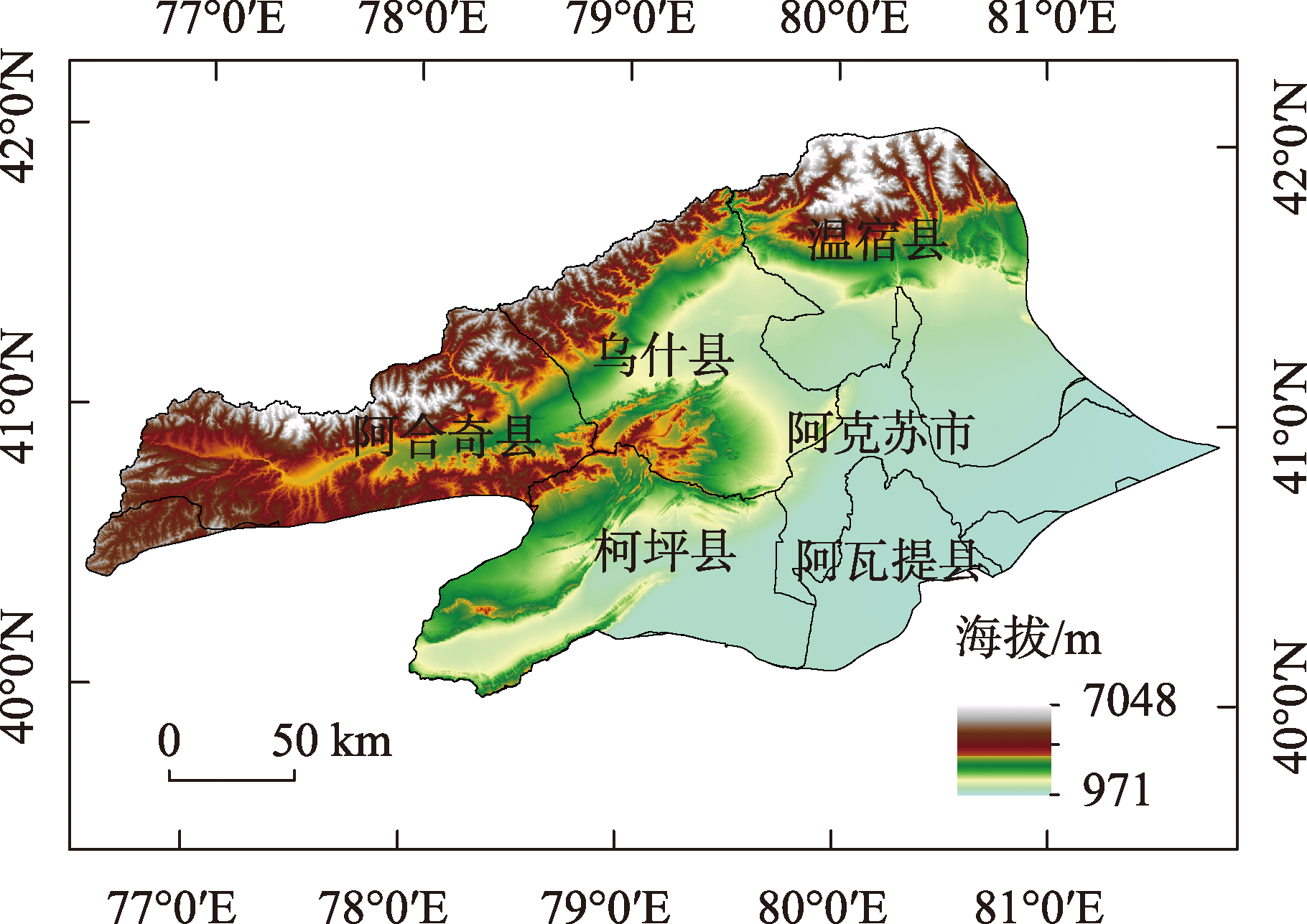
图2
阿克苏河流域土地利用类型"

表1
阿克苏河流域土地利用动态度变化"
| 土地利用类型 | 2000—2005年 | 2005—2010年 | 2010—2015年 | 2015—2020年 | |||||||
|---|---|---|---|---|---|---|---|---|---|---|---|
| 变化量/km2 | 动态度/% | 变化量/km2 | 动态度/% | 变化量/km2 | 动态度/% | 变化量/km2 | 动态度/% | ||||
| 耕地 | 805.31 | 3.47 | 590.77 | 2.17 | 731.98 | 2.42 | 21.50 | 0.06 | |||
| 林地 | -82.99 | -1.29 | -63.33 | -1.05 | -5.56 | -0.10 | -1.34 | -0.02 | |||
| 草地 | -507.11 | -0.51 | 162.01 | 0.17 | -1085.13 | -1.10 | -22.61 | -0.02 | |||
| 水域 | 28.19 | 0.27 | -1147.80 | -10.86 | 176.22 | 3.65 | 2.12 | 0.04 | |||
| 建设用地 | 12.12 | 1.06 | 117.69 | 9.75 | 32.29 | 1.80 | 43.54 | 2.23 | |||
| 未利用地 | -255.03 | -0.25 | 353.79 | 0.35 | 153.03 | 0.15 | -46.93 | -0.05 | |||
图3
2000—2020 年阿克苏河流域时间间隔层次土地利用变化强度"
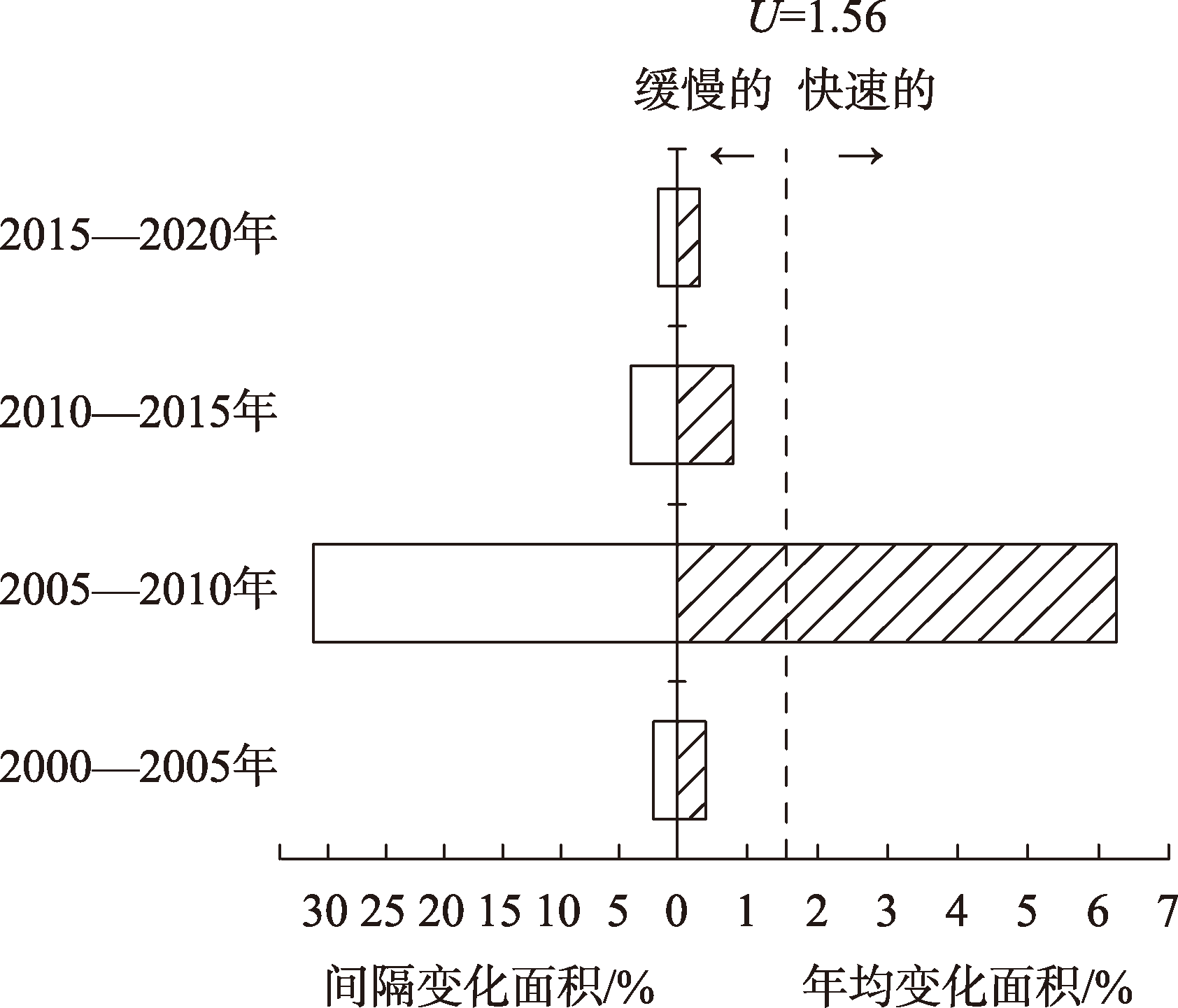

图4
2000—2020 年阿克苏河流域地类层次土地利用变化强度"

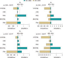
图5
2000—2020年阿克苏河流域其他地类转变为耕地的变化强度分析"

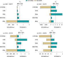
图6
2000—2020年阿克苏河流域草地转变为其他地类的变化强度分析"


图7
蒸发皿蒸发量与MOD16A2-PET拟合关系"
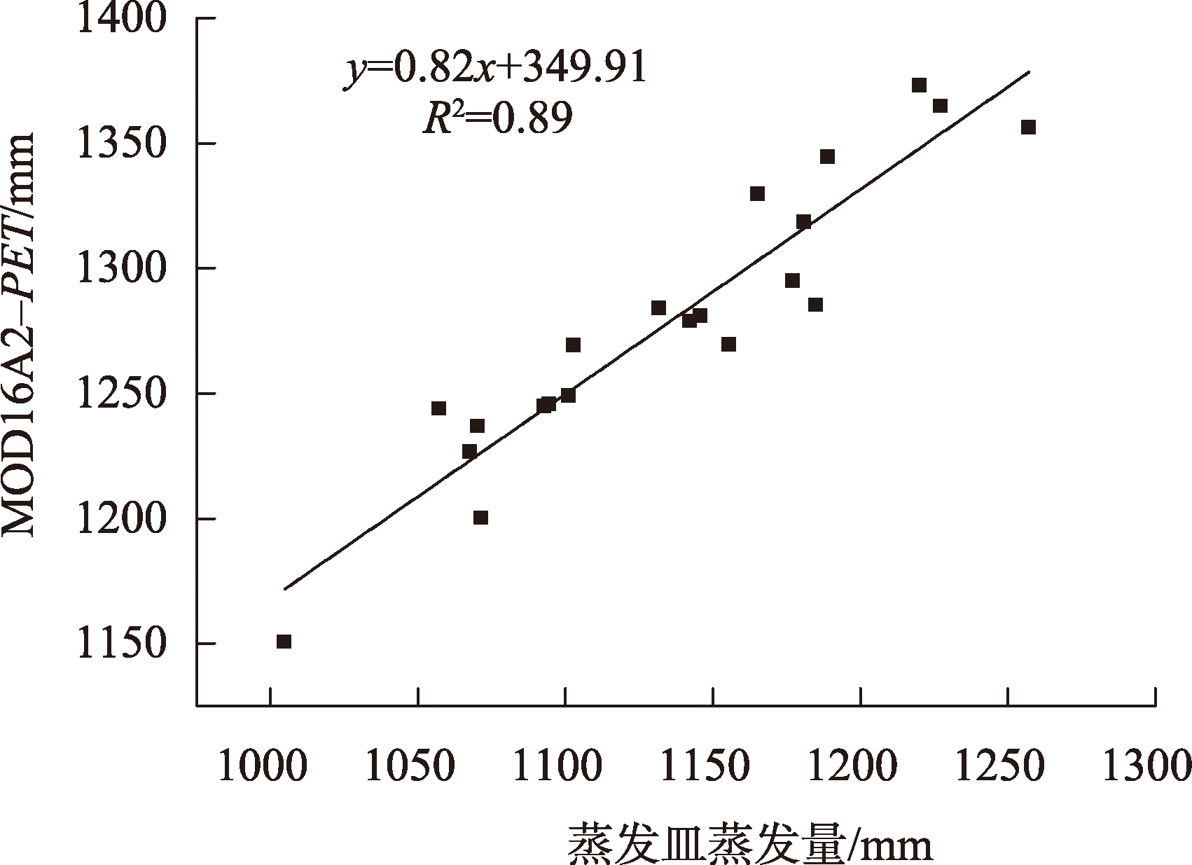
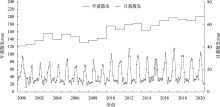
图8
阿克苏河流域ETa年际和月际变化趋势"
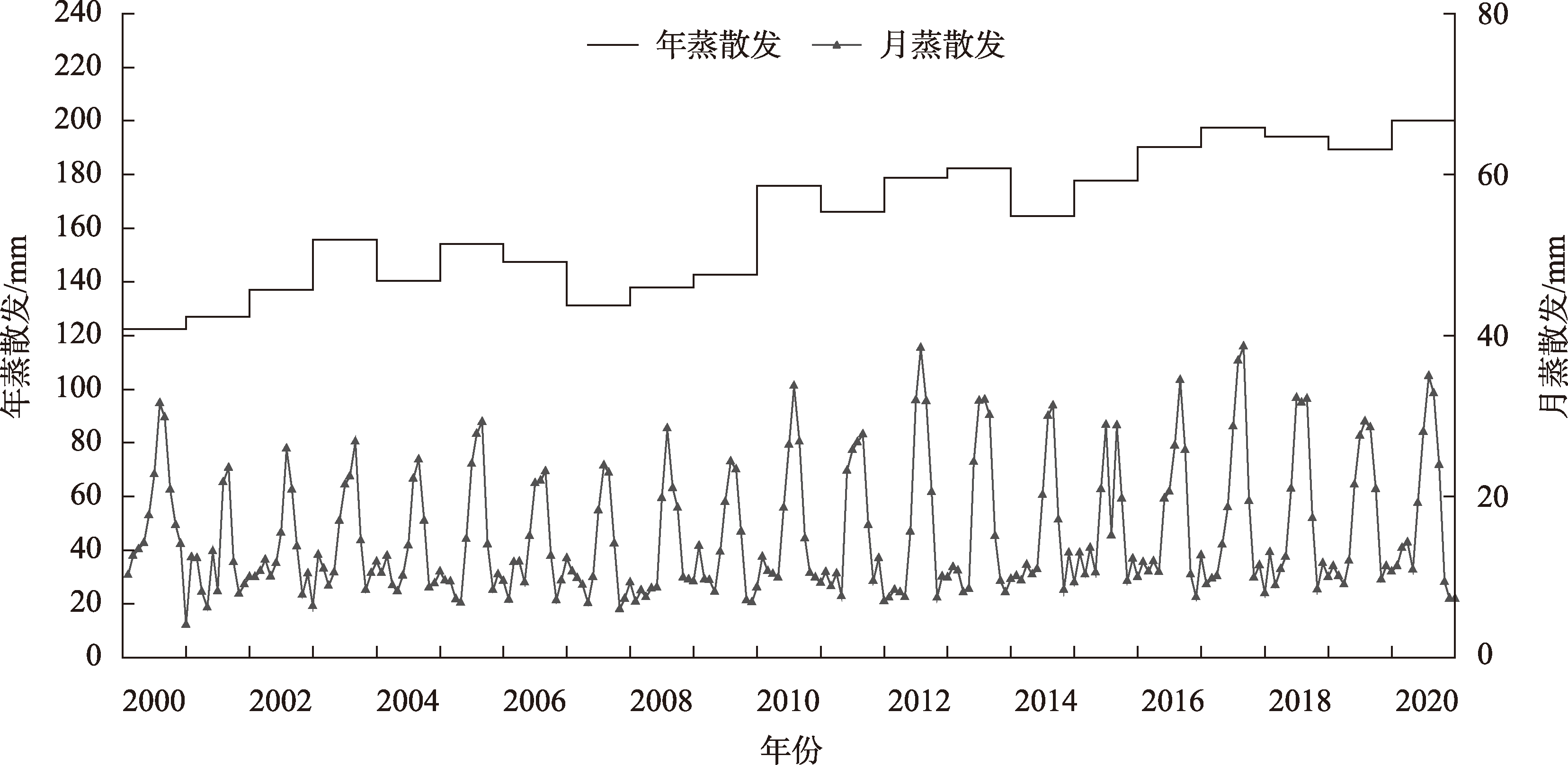
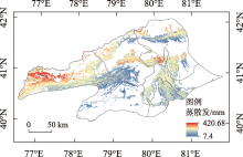
图9
阿克苏河流域多年平均蒸散发空间分布"

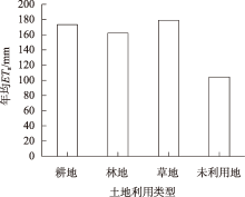
图10
阿克苏河流域各地类年均ETa"
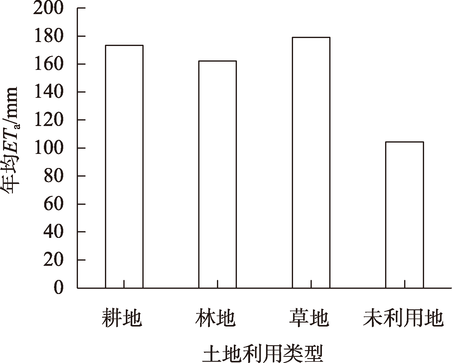
表2
驱动因子主成分特征值和贡献率"
| 主成分 | 特征值 | 贡献率/% | 累计贡献率/% |
|---|---|---|---|
| 第一 | 4.94 | 82.35 | 82.35 |
| 第二 | 0.63 | 10.48 | 92.83 |
| 第三 | 0.32 | 5.38 | 98.20 |
| 第四 | 0.06 | 0.98 | 99.18 |
| 第五 | 0.05 | 0.80 | 99.98 |
| 第六 | 0.00 | 0.02 | 100.00 |
表3
驱动因子的主成分载荷值"
| 驱动因子 | 第一主成分 | 第二主成分 |
|---|---|---|
| 草地 | 0.96 | -0.13 |
| 耕地 | 0.76 | 0.56 |
| 建设用地 | 0.91 | 0.25 |
| 林地 | 0.98 | -0.10 |
| 水域 | 0.82 | -0.47 |
| 未利用地 | 0.99 | -0.04 |
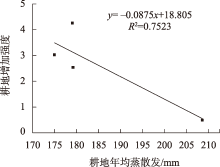
图11
耕地转入强度与年均蒸散发线性关系"

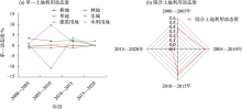
图12
单一、综合土地利用动态度"
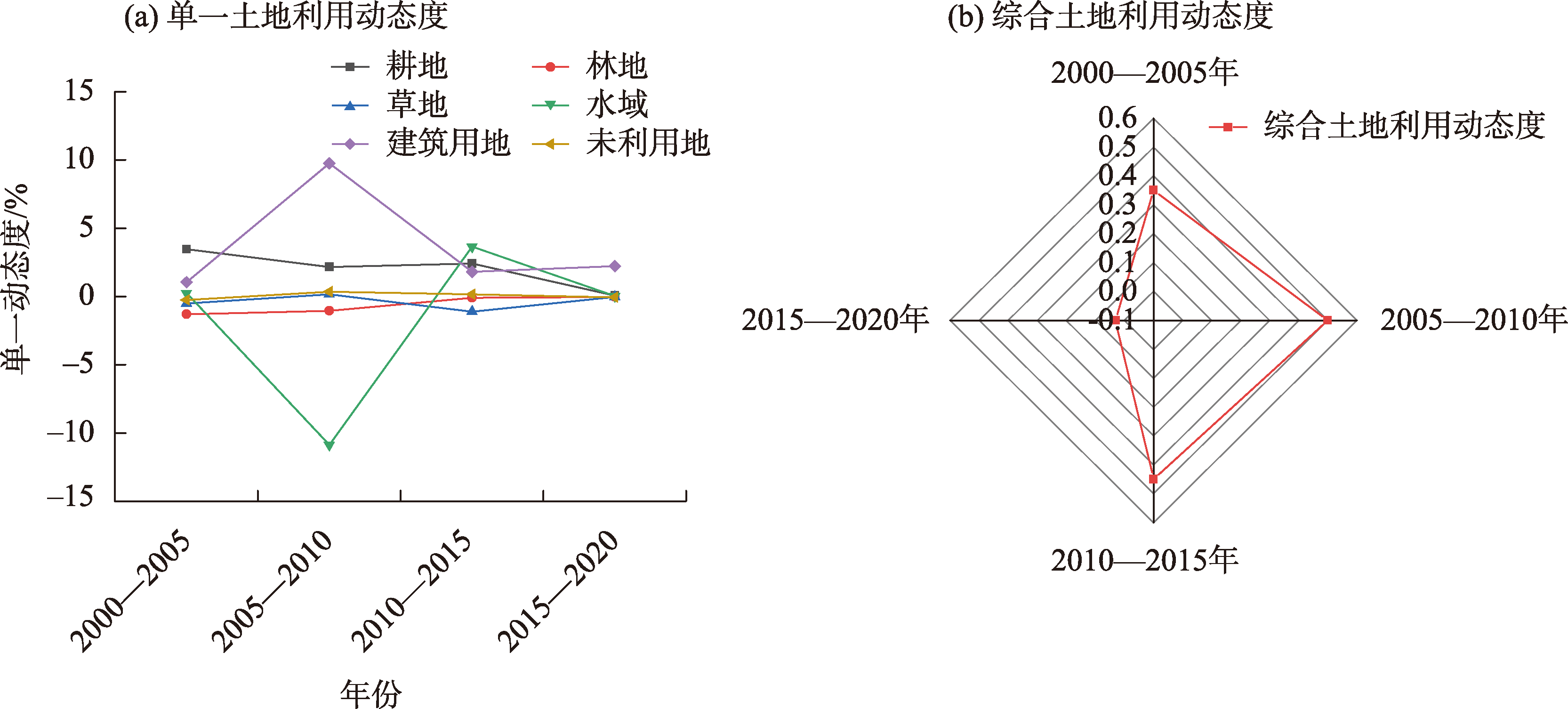
图13
2005—2010年阿克苏河流域土地利用转移弦图"

| [1] |
王旭东, 姚尧, 任书良, 等. 耦合FLUS和Markov的快速发展城市土地利用空间格局模拟方法[J]. 地球信息科学学报, 2022, 24(1): 100-113.
doi: 10.12082/dqxxkx.2022.210359 |
| [Wang Xudong, Yao Yao, Ren Shuliang, et al. A coupled FLUS and Markov approach to simulate the spatial pattern of land use in rapidly developing cities[J]. Journal of Geo-information Science, 2022, 24(1): 100-113. ] | |
| [2] | 王娇娇, 尹小君, 刘陕南, 等. 基于深度学习的玛纳斯土地利用时空格局变化与预测[J]. 干旱区研究, 2023, 40(1): 69-77. |
| [Wang Jiaojiao, Yin Xiaojun, Liu Shannan, et al. Study on the change and prediction of spatiotemporal pattern of land use in Manasi region based on deep learning[J]. Arid Zone Research, 2023, 40(1): 69-77. ] | |
| [3] | 姚佳, 陈启慧, 李琼芳, 等. 伊犁河——巴尔喀什湖流域实际蒸散发时空变化特征及其环境影响因子[J]. 干旱区研究, 2022, 39(5): 1564-1575. |
| [Yao Jia, Chen Qihui, Li Qiongfang, et al. Spatial and temporal variability of evapotranspiration and influencing factorsin the Ili River-Balkhash Lake Basin[J]. Arid Zone Research, 2022, 39(5): 1564-1575. ] | |
| [4] | Dey P, Mishra A. Separating the impacts of climate change and human activities on streamflow: A review of methodologies and critical assumptions[J]. Journal of Hydrology, 2017, 548: 278-290. |
| [5] | Wang Q, Cheng L, Zhang L, et al. Quantifying the impacts of land-cover changes on global evapotranspiration based on the continuous remote sensing observations during 1982-2016[J]. Journal of Hydrology, 2021, 598: 126231. |
| [6] | Li X Y, Zou L, Xia J, et al. Untangling the effects of climate change and land use/cover change on spatiotemporal variation of evapotranspiration over China[J]. Journal of Hydrology, 2022, 612: 128189. |
| [7] | Fisher J B, Melton F, Middleton E, et al. The future of evapotranspiration: Global requirements for ecosystem functioning, carbon and climate feedbacks, agricultural management, and water resources[J]. Water Resources Research, 2017, 53(4): 2618-2626. |
| [8] | Jasechko S, Sharp Z D, Gibson J J, et al. Terrestrial water fluxes dominated by transpiration[J]. Nature, 2013, 496(7445): 347-350. |
| [9] | Pascolini-Campbell M, Reager J T, Chandanpurkar H A, et al. A 10 per cent increase in global land evapotranspiration from 2003 to 2019[J]. Nature, 2022, 604(7904): 202. |
| [10] | 王颖慧, 丁建丽, 李晓航, 等. 伊犁河流域土地利用/覆被变化对生态系统服务价值的影响——基于强度分析模型[J]. 生态学报, 2022, 42(8): 3106-3118. |
| [Wang Yinghui, Ding Jianli, Li Xiaohang, et al. Impact of LUCC on ecosystem services values in the Yili River Basin based on an intensity analysis model[J]. Acta Ecologica Sinica, 2022, 42(8): 3106-3118. ] | |
| [11] | Aldwaik Z S, Pontius G R. Intensity analysis to unify measurements of size and stationarity of land changes by interval, category, and transition[J]. Landscape and Urban Planning, 2012, 106(1): 103-144. |
| [12] | Huang J, Pontius Jr R G, Li Q, e t al. Use of intensity analysis to link pat terns with processes of land change from 1986 to 2007 in a coastal watershed of southeast China[J]. Applied Geography, 2012, 34: 371-384. |
| [13] |
杨建新, 龚健, 高静, 等. 国家中心城市土地利用变化稳定性和系统性特征——以武汉市为例[J]. 资源科学, 2019, 41(4): 701-716.
doi: 10.18402/resci.2019.04.08 |
|
[Yang Jianxin, Gong Jian, Gao Jing, et al. Stationary and systematic characteristics of land use and land cover change in the national central cities of China using intensity analysis: A case study of Wuhan City[J]. Resources Science, 2019, 41(4): 701-716. ]
doi: 10.18402/resci.2019.04.08 |
|
| [14] | 田立鑫, 韩美, 王敏, 等. 莱州湾南岸海岸带土地利用时空演变及稳定性研究[J]. 水土保持研究, 2021, 28(4): 259-265, 274, 2. |
| [Tian Lixin, Han Mei, Wang Min, et al. Spatiotemporal evolution and stability of land use type in the coastal zone of the south coast in Laizhou Bay[J]. Research of Soil and Water Conservation, 2021, 28(4): 259-265, 274, 2. ] | |
| [15] |
孙云华, 郭涛, 崔希民. 昆明市土地利用变化的强度分析与稳定性研究[J]. 地理科学进展, 2016, 35(2): 245-254.
doi: 10.18306/dlkxjz.2016.02.011 |
|
[Sun Yunhua, Guo Tao, Cui Ximin. Intensity analysis and stationarity of land use change in Kunming City[J]. Progress in Geography, 2016, 35(2): 245-254. ]
doi: 10.18306/dlkxjz.2016.02.011 |
|
| [16] | 谭雪晶, 姜广辉, 付晶, 等. 主体功能区规划框架下国土开发强度分析——以北京市为例[J]. 中国土地科学, 2011, 25(1): 70-77. |
| [Tan Xuejing, Jiang Guanghui, Fu Jing, et al. Analysis on land development intensity under the framework of major functional land zoning: Taking Beijing as an example[J]. China Land Science, 2011, 25(1): 70-77. ] | |
| [17] | Deng Z, Quan B. Intensity analysis to communicate detailed detection of land use and land cover change in Chang-Zhu-Tan Metropolitan Region, China[J]. Forests, 2023, 14(5): 939. |
| [18] | 阿曼妮萨·库尔班, 满苏尔·沙比提, 艾克旦·依萨克, 等. 近19年新疆阿克苏河流域耕地利用时空演变特征[J]. 中国水土保持科学(中英文), 2022, 20(3): 72-80. |
| [Amanisa Korban, Mansur Shabiti, Ekdan Isaak, et al. Spatiotemporal evolution of arable land use in Aksu River Basin, Xinjiang in recent 19 years[J]. Science of Soil and Water Conservation, 2022, 20(3): 72-80. ] | |
| [19] | 曹永香, 毛东雷, 薛杰, 等. 绿洲-沙漠过渡带植被覆盖动态变化及其驱动因素——以新疆策勒为例[J]. 干旱区研究, 2022, 39(2): 510-521. |
| [Cao Yongxiang, Mao Donglei, Xue Jie, et al. Dynamic changes and driving factors of vegetation cover in the oasis-desert ecotone: A case study of Cele, Xinjiang[J]. Arid Zone Research, 2022, 39(2): 510-521. ] | |
| [20] |
张静, 任志远. 基于MOD16的汉江流域地表蒸散发时空特征[J]. 地理科学, 2017, 37(2): 274-282.
doi: 10.13249/j.cnki.sgs.2017.02.014 |
|
[Zhang Jing, Ren Zhiyuan. Spatiotemporal characteristics of evapotranspiration based on MOD16 in the Hanjiang River Basin[J]. Scientia Geographica Sinica, 2017, 37(2): 274-282. ]
doi: 10.13249/j.cnki.sgs.2017.02.014 |
|
| [21] | 王卓月, 孔金玲, 李英, 等. 基于MOD16的银川平原地表蒸散量时空特征及影响因素分析[J]. 水文地质工程地质, 2021, 48(3): 53-61. |
| [Wang Zhuoyue, Kong Jinling, Li Ying, et al. An analysis of spatio-temporal characteristics and influencing factors of surface evapotranspiration in the Yinchuan Plain based on MOD16 data[J]. Hydrogeology & Engineering Geology, 2021, 48(3): 53-61. ] | |
| [22] | 李晴, 杨鹏年, 彭亮, 等. 基于MOD16数据的焉耆盆地蒸散量变化研究[J]. 干旱区研究, 2021, 38(2): 351-358. |
| [Li Qing, Yang Pengnian, Peng Liang, et al. Study of the variation trend of evapotranspiration in the Yanqi Basin based on MOD16 data[J]. Arid Zone Research, 2019, 38(2): 351-358. ] | |
| [23] | 王志成, 李稚, 张辉, 等. 阿克苏河流域灌区土地利用变化对蒸散耗水的影响[J]. 灌溉排水学报, 2018, 37(6): 79-85. |
| [Wang Zhicheng, Li Zhi, Zhang Hui, et al. The impact of land use change on evapotranspiration of the irrigated areas in Aksu Basin[J]. Journal of Irrigation and Drainage, 2018, 37(6): 79-85. ] | |
| [24] | 王欣珂, 林弘, 谢香群, 等. 闽江流域土地利用时空变化特征及驱动因子分析[J]. 生态科学, 2023, 42(4): 171-181. |
| [Wang Xinke, Lin Hong, Xie Xiangqun, et al. Spatiotemporal change characteristics and driving factors of landuse in Minjiang River Basin[J]. Ecological Sciences, 2023, 42(4): 171-181. ] | |
| [25] | 危小建, 赵莉, 程朋根, 等. 中国土地利用与生态服务价值空间动态研究——以地级及以上城市为例[J]. 水土保持研究, 2022, 29(4): 370-376. |
| [Wei Xiaojian, Zhao Li, Cheng Pengen, et al. Research on the spatial dynamics of land use and ecological service value in China: Taking prefecture-level cities and beyond as an example[J]. Research of Soil and Water Conservation, 2022, 29(4): 370-376. ] | |
| [26] |
付乐, 迟妍妍, 于洋, 等. 2000—2020年黄河流域土地利用变化特征及影响因素分析[J]. 生态环境学报, 2022, 31(10): 1927-1938.
doi: 10.16258/j.cnki.1674-5906.2022.10.001 |
| [Fu Le, Chi Yanyan, Yu Yang, et al. Characteristics and driving forces of land use change in the Yellow River Basin from 2000 to 2020[J]. Ecological and Environmental Sciences, 2022, 31(10): 1927-1938. ] | |
| [27] | 黄钰清, 李骁尧, 于强, 等. 1995-2018年黄河流域土地利用变化及驱动力分析[J]. 西北林学院学报, 2022, 37(6): 113-121. |
| [Huang Yuqing, Li Xiaoyao, Yu Qiang, et al. An analysis of land use change and driving forces in the Yellow River Basin from 1995 to 2018[J]. Journal of Northwest Forestry University, 2022, 37(6): 113-121. ] | |
| [28] | 严长安, 杨汝兰, 付潇华, 等. 土地利用变化对滇池流域生态系统服务价值的影响[J]. 生态学报, 2023, 43(15): 6194-6202. |
| [Yan Chang’an, Yang Rulan, Fu Xiaohua, et al. Impact of land-use change on ecosystem services value in Dianchi Lake Basin[J]. Acta Ecologica Sinica, 2023, 43(15): 6194-6202. ] | |
| [29] | 苏迎庆, 张恩月, 刘源, 等. 汾河流域土地利用变化及生态环境效应[J]. 干旱区研究, 2022, 39(3): 968-977. |
| [Su Yingqing, Zhang Enyue, Liu Yuan, et al. Land-use change and ecological environment effects on Fenhe River Basin[J]. Arid Zone Research, 2022, 39(3): 968-977. ] | |
| [30] | 高宇婷, 于洋, 孙凌霄, 等. 塔里木盆地南缘绿洲土地覆盖变化及驱动力[J]. 干旱区研究, 2021, 38(4): 1172-1183. |
| [Gao Yuting, Yu Yang, Sun Lingxiao, et al. Land coverage change and driving forces of an oasis in the southern margin of Tarim Basin[J]. Arid Zone Research, 2021, 38(4): 1172-1183. ] | |
| [31] | 牛乐乐, 张必成, 贾天忠, 等. 青海省海西州土地利用变化强度分析与稳定性研究[J]. 水土保持学报, 2021, 35(2): 152-159. |
| [Niu Lele, Zhang Bicheng, Jia Tianzhong, et al. Analysis on intensity and stability of land use change in Haixi Mongolian and Tibetan Autonomous Prefecture of Qinghai Province[J]. Journal of Soil and Water Conservation, 2021, 35(2): 152-159. ] | |
| [32] |
李帅呈, 龚健, 杨建新, 等. 兰西城市群土地利用/覆被变化模式特征——基于强度分析框架[J]. 资源科学, 2023, 45(3): 480-493.
doi: 10.18402/resci.2023.03.02 |
|
[Li Shuaicheng, Gong Jian, Yang Jianxin, et al. Characteristics of LUCC patterns of the Lanzhou-Xining urban agglomeration: Based on an intensity analysis framework[J]. Resources Science, 2023, 45(3): 480-493. ]
doi: 10.18402/resci.2023.03.02 |
|
| [33] | 郭晓彤, 孟丹, 蒋博武, 等. 基于MODIS蒸散量数据的淮河流域蒸散发时空变化及影响因素分析[J]. 水文地质工程地质, 2021, 48(3): 45-52. |
| [Guo Xiaotong, Meng Dan, Jiang Bowu, et al. Spatio-temporal change and influencing factors of evapotranspiration in the Huaihe River Basin based on MODIS evapotranspiration data[J]. Hydrogeology & Engineering Geology, 2021, 48(3): 45-52. ] |
| [1] | 张顺鑫, 吴子豪, 闫庆武, 李桂娥, 牟守国. 基于PLUS-InVEST模型的天山北坡生态系统碳储量时空变化与预测[J]. 干旱区研究, 2024, 41(7): 1228-1237. |
| [2] | 李冰洁, 范志韬, 曲芷程, 姚顺予, 宿夏姝, 刘东伟, 王立新. 基于InVEST-PLUS模型的黄河流域内蒙古段生态系统碳储量评价及预测[J]. 干旱区研究, 2024, 41(7): 1217-1227. |
| [3] | 李沛尧, 王新军, 许世贤, 高胜寒, 薛智暄, 衡瑞. 基于PLUS土地利用模拟的阿克苏河流域NEP时空格局研究[J]. 干旱区研究, 2024, 41(6): 1059-1068. |
| [4] | 李佳珂, 邵战林. 基于PLUS和InVEST模型的乌鲁木齐市碳储量时空演变与预测[J]. 干旱区研究, 2024, 41(3): 499-508. |
| [5] | 孙茂森,王让会,宁虎森. 阿克苏河流域生态网络构建[J]. 干旱区研究, 2023, 40(9): 1509-1516. |
| [6] | 吕锦心, 梁康, 刘昌明, 张仪辉, 刘璐. 无定河流域土地覆被空间分异机制及相关水碳变量变化[J]. 干旱区研究, 2023, 40(4): 563-572. |
| [7] | 刘畅,张红,张霄羽,杨国婷,刘勇. 半干旱地区矿区土地利用时空演变与预测[J]. 干旱区研究, 2022, 39(1): 292-300. |
| [8] | 吝静,赵成义,马晓飞,施枫芝,吴世新,朱建. 基于生态系统服务价值的塔里木河干流土地利用结构优化[J]. 干旱区研究, 2021, 38(4): 1140-1151. |
| [9] | 秦埼瑞, 李雪梅, 陈庆伟, 田亚林. 基于FLUS模型的天山山区未来土地利用变化预估 [J]. 干旱区研究, 2019, 36(5): 1270-1279. |
| [10] | 贺 可,吴世新,周宏飞,杨中惠,杨怡. 玛纳斯河流域两种典型土地利用变化分析[J]. 干旱区研究, 2018, 35(4): 954-962. |
| [11] | 王生霞, 叶柏生, 丁永建, 赵传成, 秦甲. 绿洲耗水对阿克苏河流域地表径流的影响[J]. 干旱区研究, 2013, 30(2): 203-210. |
| [12] | 穆振侠, 谢蕾, 姜卉芳. NCEP/NCAR再分析气温在阿克苏河流域的适用性分析[J]. 干旱区研究, 2012, 29(5): 832-837. |
| [13] | 邓茂芝,王英巍,毛炜峄,刘寿东. 阿克苏河流域公众气候变化感知及适应措施选择的差异分析[J]. 干旱区研究, 2012, 29(1): 17-26. |
|
||