干旱区研究 ›› 2022, Vol. 39 ›› Issue (5): 1345-1359.doi: 10.13866/j.azr.2022.05.02 cstr: 32277.14.AZR.20220502
把黎1,2( ),尹宪志1(),庞朝云1,程鹏3,刘维成4,王研峰1
收稿日期:2021-12-14
修回日期:2022-06-13
出版日期:2022-09-15
发布日期:2022-10-25
作者简介:把黎(1990-),女,工程师,主要从事云降水与人工影响天气研究. E-mail: 基金资助:
BA Li1,2(),YIN Xianzhi1(),PANG Zhaoyun1,CHENG Peng3,LIU Weicheng4,WANG Yanfeng1
Received:2021-12-14
Revised:2022-06-13
Published:2022-09-15
Online:2022-10-25
摘要:
利用欧洲中期天气预报中心(ECMWF)提供的高时空分辨率ERA5再分析资料,对祁连山地区夏季空中云水资源的时空分布及南北坡差异特征进行研究,并估算水汽凝结效率及水凝物降水效率。研究表明:大气环流以及地形引起的低层水汽场辐合和上升气流对祁连山地区空中云水资源分布起到关键作用。(1) 在平均状态下,祁连山地区夏季水汽含量南坡略小于北坡,云水路径南坡大于北坡,南坡500 hPa以下是云液水含量富集区。近年来,水汽含量及云液水含量呈上升趋势,且南坡增速大于北坡;云冰水含量呈下降趋势,且北坡下降速度大于南坡。(2) 夏季白天北坡存在定常性上升气流,且该上升气流可持续到对流层中层,南坡低层为水汽通量辐合区。(3) 在不同降水环流下,偏西或西北气流形势时,北坡云水分布较南坡更为充沛,且多以含水性低云为主;西南气流形势时,云水厚度更深,南北坡云水差异不大。(4) 祁连山区尤其是南坡,空中云水资源相对丰富,且较大部分水凝物未能成为降水,增雨潜力更高,但其云水分布并不固定,也与降水环流形势有关。因此,祁连山上空云水资源分布的不均匀性及多变性需要在开发过程中更有针对性的选择作业区域及作业手段。
把黎,尹宪志,庞朝云,程鹏,刘维成,王研峰. 祁连山地区夏季南坡与北坡空中云水资源差异性分析[J]. 干旱区研究, 2022, 39(5): 1345-1359.
BA Li,YIN Xianzhi,PANG Zhaoyun,CHENG Peng,LIU Weicheng,WANG Yanfeng. Characteristics of the difference in air water resources between the north and south slopes of the Qilian Mountains in the summer[J]. Arid Zone Research, 2022, 39(5): 1345-1359.
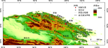
图1
祁连山地区地貌及周边探空站示意图"
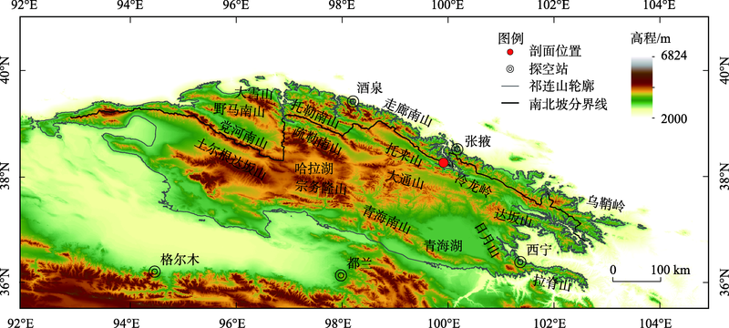
表1
ERA5格点数据与探空站比湿相关性检验"
| 站名 | 海拔/m | 经度 | 纬度 | 相关系数 |
|---|---|---|---|---|
| 酒泉 | 1479 | 98.29°E | 39.46°N | 0.96 |
| 张掖 | 1483 | 100.26°E | 38.56°N | 0.95 |
| 格尔木 | 2812 | 94.54°E | 36.25°N | 0.94 |
| 都兰 | 3191 | 98.06°E | 36.18°N | 0.94 |
| 西宁 | 2299 | 101.45°E | 36.43°N | 0.97 |
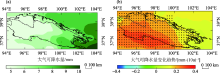
图2
1979—2019年祁连山地区夏季(6—8月)大气可降水量分布和变化趋势 注:黑色实线为祁连山轮廓,黑色点划线为祁连山南北坡分界线,打点区域表示通过95%置信度的显著性检验。下同。"
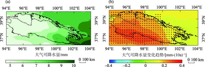
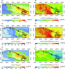
图3
1979—2019年祁连山地区夏季(6—8月)云水路径、云液水含量、云冰水含量分布和变化趋势"

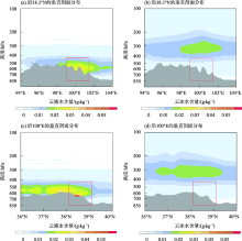
图4
1979—2019年祁连山地区夏季(6—8月)云液水含量和云冰水含量沿38.3°N和100°E的垂直剖面分布 注:灰色阴影为地形,红色方框为冷龙岭地区。下同。"
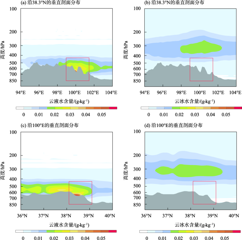
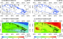
图5
1979—2019年祁连山地区夏季(6—8月)整层纬向和经向水汽通量分布和变化趋势 注:实线代表向东、向北的水汽通量;虚线代表向西、向南的水汽通量;水汽通量单位为kg·m-1·s-1;水汽通量变化趋势单位为kg·m-1·s-1·(10a)-1。"

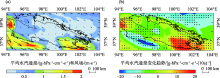
图6
1979—2019年祁连山地区夏季(6—8月)650 hPa平均水汽通量和平均风场分布以及平均水汽通量变化趋势"
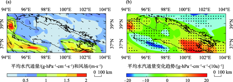

图7
1979—2019年祁连山地区夏季(6—8月)物理量场在白天和夜间沿38.3°N和100°E的垂直剖面分布 注:彩色阴影为水汽通量散度,单位:10-7 g·hPa-1·cm-2·s-1;风场中垂直速度放大了100倍,单位为m·s-1;黑色点线为垂直速度,单位为Pa·s-1。"
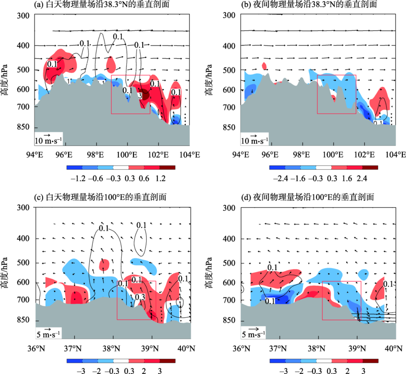
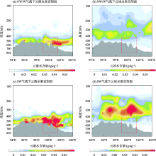
图8
1979—2019年祁连山地区夏季(6—8月)云液水含量和云冰水含量在偏西或西北气流和西南气流下沿38.3°N的垂直剖面"
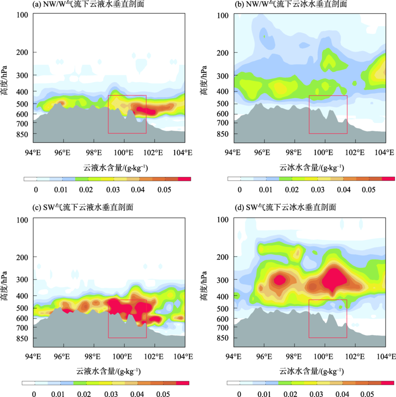
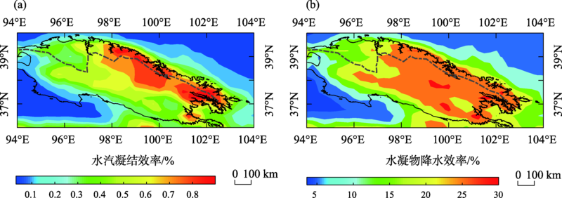
图9
2005—2019年祁连山地区水汽凝结效率和水凝物降水效率分布"
| [1] | 李新, 勾晓华, 王宁练, 等. 祁连山绿色发展: 从生态治理到生态恢复[J]. 科学通报, 2019, 64(27): 2928-2937. |
| [Li Xin, Gou Xiaohua, Wang Ninglian, et al. Tightening ecological management facilitates green development in the Qilian Mountains[J]. Chinese Science Bulletin, 2019, 64(27): 2928-2937. ] | |
| [2] |
Yao Tandong. Tackling on environmental changes in Tibetan Plateau with focus on water, ecosystem and adaptation[J]. Science Bulletin, 2019, 64(7): 417.
doi: 10.1016/j.scib.2019.03.033 |
| [3] | 程国栋, 王根绪. 中国西北地区的干旱与旱灾——变化趋势与对策[J]. 地学前缘, 2006, 13(1): 3-14. |
| [Cheng Guodong, Wang Genxu. Changing trend of drought and drought disaster in Northwest China and countermeasures[J]. Earth Science Frontiers, 2006, 13(1): 3-14. ] | |
| [4] | 王静, 尉元明, 郭铌, 等. 祁连山空中云水资源开发利用效益预测与评估[J]. 自然资源学报, 2007, 22(3): 463-470. |
| [Wang Jing, Wei Yuanming, Guo Ni, et al. Beneficial prediction and assessment of cloud and air water resource exploitation over the Qilian Mountain[J]. Journal of Natural Resources, 2007, 22(3): 463-470. ] | |
| [5] |
张强, 姚玉璧, 李耀辉, 等. 中国西北地区干旱气象灾害监测预警与减灾技术研究进展及其展望[J]. 地球科学进展, 2015, 30(2): 196-211.
doi: 10.11867/j.issn.1001-8166.2015.02.0196 |
|
[Zhang Qiang, Yao Yubi, Li Yaohui, et al. Research progress and prospect on the monitoring and early warning and mitigation technology of meteorological drought disaster in Northwest China[J]. Advances in Earth Science, 2015, 30(2): 196-211. ]
doi: 10.11867/j.issn.1001-8166.2015.02.0196 |
|
| [6] | 王玉洁, 秦大河. 气候变化及人类活动对西北干旱区水资源影响研究综述[J]. 气候变化研究进展, 2017, 13(5): 483-493. |
| [Wang Yujie, Qin Dahe. Influence of climate change and human activity on water resources in arid region of Northwest China: An overview[J]. Climate Change Research, 2017, 13(5): 483-493. ] | |
| [7] | 张强, 赵映东, 张存杰, 等. 西北干旱区水循环与水资源问题[J]. 干旱气象, 2008, 26(2): 1-8. |
| [Zhang Qiang, Zhao Yingdong, Zhang Cunjie, et al. Issues about hydrological cycle and water resource in arid region of Northwest China[J]. Journal of Arid Meteorology, 2008, 26(2): 1-8. ] | |
| [8] | 王光谦, 钟德钰, 李铁键, 等. 天空河流: 发现、概念及其科学问题[J]. 中国科学: 技术科学, 2016, 46(6): 649-656. |
| [Wang Guangqian, Zhong Deyu, Li Tiejian, et al. Sky River: Discovery, concept, and implications for future research[J]. Scientia Sinica Technologica, 2016, 46(6): 649-656. ] | |
| [9] | 李家叶, 李铁键, 王光谦, 等. 空中水资源及其降水转化分析[J]. 科学通报, 2018, 63(26): 2785-2796. |
| [Li Jiaye, Li Tiejian, Wang Guangqian, et al. Atmospheric water resource and precipitation conversion[J]. Chinese Science Bulletin, 2018, 63(26): 2785-2796. ] | |
| [10] |
Cai Miao, Zhou Yuquan, Liu Jianzhao, et al. Quantifying the cloud water resource: Methods based on observational diagnosis and cloud model simulation[J]. Journal of Meteorological Research, 2020, 34(6): 1256-1270.
doi: 10.1007/s13351-020-9126-6 |
| [11] | 黄美元. 我国人工降水亟待解决的问题和发展思路[J]. 气候与环境研究, 2011, 16(5): 543-550. |
| [Huang Meiyuan. Urgent problems and thinking of development for precipitation anhancement in China[J]. Climatic and Environmental Research, 2011, 16(5): 543-550. ] | |
| [12] | 洪延超, 雷恒池. 云降水物理和人工影响天气研究进展和思考[J]. 气候与环境研究, 2012, 17(6): 951-967. |
| [Hong Yanchao, Lei Hengchi. Research advance and thinking of the cloud precipitation physics and weather modification[J]. Climatic and Environmental Research, 2012, 17(6): 951-967. ] | |
| [13] | 郭学良, 付丹红, 胡朝霞. 云降水物理与人工影响天气研究进展(2008-2012年)[J]. 大气科学, 2013, 37(2): 351-363. |
| [Guo Xueliang, Fu Danhong, Hu Zhaoxia. Progress in cloud physics, precipitation, and weather modification during 2008-2012[J]. Chinese Journal of Atmospheric Sciences, 2013, 37(2): 351-363. ] | |
| [14] | 陈添宇, 李照荣, 陈乾, 等. 用GMS5卫星反演水汽场分析中国西北地区大气水汽分布的气候特征[J]. 大气科学, 2005, 29(6): 864-871. |
| [Chen Tianyu, Li Zhaorong, Chen Qian, et al. The analysis of climate characteristics of water vapor distribution over Northwest China with water vapor field retrieved from GMS5 satellite data[J]. Chinese Journal of Atmospheric Sciences, 2005, 29(6): 864-871. ] | |
| [15] | 陈勇航, 黄建平, 王天河, 等. 西北地区不同类型云的时空分布及其与降水的关系[J]. 应用气象学报, 2005, 16(6): 717-727. |
| [Chen Yonghang, Huang Jianping, Wang Tianhe, et al. Temporal and spatial distribution of the different clouds over northwestern China with the relation to precipitation[J]. Journal of Applied Meteorological Science, 2005, 16(6): 717-727. ] | |
| [16] | 陈乾, 陈添宇, 张鸿. 用Aqua/CERES反演的云参量估算西北区降水效率和人工增雨潜力[J]. 干旱气象, 2006, 24(4): 1-8. |
| [Chen Qian, Chen Tianyu, Zhang Hong. Estimates of precipitation efficiency and latent capacity of artificial precipitation over Northwest china using Aqua/CERES data retrieval of cloud parameters[J]. Arid Meteorology, 2006, 24(4): 1-8. ] | |
| [17] | 郭良才, 白虎志, 岳虎, 等. 祁连山区空中水汽资源的分布特征及其开发潜力[J]. 资源科学, 2007, 29(2): 68-73. |
| [Guo Liangcai, Bai Huzhi, Yue Hu, et al. The distributional characteristics and development potential of water vapor resources over Qilian Moutain areas[J]. Resources Science, 2007, 29(2): 68-73. ] | |
| [18] |
Giovannettone J P, Barros A P. Probing regional orographic controls of precipitation and cloudiness in the central Andes using satellite data[J]. Journal of Hydrometeorology, 2009, 10(1): 167-182.
doi: 10.1175/2008JHM973.1 |
| [19] |
Smith B L, Yuter S E, Neiman P J, et al. Water vapor fluxes and orographic precipitation over northern California associated with a landfalling atmospheric river[J]. Monthly Weather Review, 2010, 138(1): 74-100.
doi: 10.1175/2009MWR2939.1 |
| [20] | 张小娟, 王军, 黄观, 等. 新疆3大山区云中液态水时空分布特征[J]. 干旱区研究, 2018, 35(4): 846-854. |
| [Zhang Xiaojuan, Wang Jun, Huang Guan, et al. Spatiotemporal distribution of cloud liquid water volume over three main mountains in Xinjiang[J]. Arid Zone Research, 2018, 35(4): 846-854. ] | |
| [21] | 刘玉芝, 常姝婷, 华珊, 等. 东亚干旱半干旱区空中水资源研究进展[J]. 气象学报, 2018, 76(3): 485-492. |
| [Liu Yuzhi, Chang Shuting, Hua Shan, et al. A review of the research on atmospheric water resources over arid and semi-arid regions of East Asia[J]. Acta Meteorologica Sinica, 2018, 76(3): 485-492. ] | |
| [22] | 王可丽, 江灏, 赵红岩. 西风带与季风对中国西北地区的水汽输送[J]. 水科学进展, 2005, 16(3): 432-438. |
| [Wang Keli, Jiang Hao, Zhao Hongyan. Atmospheric water vapor transport from westerly and monsoon over the Northwest China[J]. Advances in Water Science, 2005, 16(3): 432-438. ] | |
| [23] | 张强, 张杰, 孙国武, 等. 祁连山山区空中水汽分布特征研究[J]. 气象学报, 2007, 65(4): 633-643. |
| [Zhang Qiang, Zhang Jie, Sun Guowu, et al. Research on atmospheric water-vapor distribution over Qilianshan Mountains[J]. Acta Meteorologica Sinica, 2007, 65(4): 633-643. ] | |
| [24] | 刘卫国, 刘奇俊. 祁连山夏季地形云结构和云微物理过程的模拟研究(I): 模式云物理方案和地形云结构[J]. 高原气象, 2007, 26(1): 1-15. |
| [Liu Weiguo, Liu Qijun. The numerical simulation of orographic cloud structure and cloud microphysical processes in Qilian Mountains in summer. part(I): Cloud microphysical scheme and orographic cloud stucture[J]. Plateau Meteorology, 2007, 26(1): 1-15. ] | |
| [25] | 张强, 孙昭萱, 陈丽华, 等. 祁连山空中云水资源开发利用研究综述[J]. 干旱区地理, 2009, 32(3): 381-390. |
| [Zhang Qiang, Sun Zhaoxuan, Chen Lihua, et al. Reviews on studies of exploitation and utilization of cloud-water resource in the Qilian Mountains region[J]. Arid Land Geography, 2009, 32(3): 381-390. ] | |
| [26] | 杜亮亮, 李江萍, 陈晓燕, 等. 2001-2011年青藏高原东北边坡地带云水资源分析[J]. 干旱区研究, 2012, 29(5): 862-869. |
| [Du Liangliang, Li Jiangping, Chen Xiaoyan, et al. Analysis on cloud and vapor flux in the northeast of the Qinghai-Tibet Plateau during the period from 2001 to 2011[J]. Arid Zone Research, 2012, 29(5): 862-869. ] | |
| [27] | 王研峰, 王聚杰, 尹宪志, 等. 祁连山云特征参数及人工增雨研究进展与展望[J]. 冰川冻土, 2019, 41(2): 434-443. |
| [Wang Yanfeng, Wang Jujie, Yin Xianzhi, et al. Cloud characteristic parameters and artificial precipitation in the Qilian Mountains: Research progress and prospect[J]. Journal of Glaciology and Geocryology, 2019, 41(2): 434-443. ] | |
| [28] |
郑国光, 陈跃, 陈添宇, 等. 祁连山夏季地形云综合探测试验[J]. 地球科学进展, 2011, 26(10): 1057-1070.
doi: 10.11867/j.issn.1001-8166.2011.10.1057 |
|
[Zheng Guoguang, Chen Yue, Chen Tianyu, et al. The observational study of summer orographic clouds structures of Qilian Mountains[J]. Advances in Earth Science, 2011, 26(10): 1057-1070. ]
doi: 10.11867/j.issn.1001-8166.2011.10.1057 |
|
| [29] | 张杰, 张强, 田文寿, 等. 祁连山区云光学特征的遥感反演与云水资源的分布特征分析[J]. 冰川冻土, 2006, 28(5): 722-727. |
| [Zhang Jie, Zhang Qiang, Tian Wenshou, et al. Remote sensing retrieval and analysis of optical character of cloud in Qilian Mountains[J]. Journal of Glaciology and Geocryology, 2006, 28(5): 722-727. ] | |
| [30] | 程鹏, 罗汉, 常祎, 等. 祁连山一次地形云降水微物理特征飞机观测[J]. 应用气象学报, 2021, 32(6): 691-705. |
| [Cheng Peng, Luo Han, Chang Yi, et al. Aircraft measurement of microphysical characteristics of a topographic cloud precipitation in Qilian Mountains[J]. Journal of Applied Meteorological Science, 2021, 32(6): 691-705. ] | |
| [31] |
贾文雄, 何元庆, 李宗省, 等. 祁连山区气候变化的区域差异特征及突变分析[J]. 地理学报, 2008, 63(3): 257-269.
doi: 10.11821/xb200803004 |
|
[Jia Wenxiong, He Yuanqing, Li Zongxing, et al. The regional difference and catastrophe of climatic change in Qilian Mt. region[J]. Acta Geographica Sinica, 2008, 63(3): 257-269. ]
doi: 10.11821/xb200803004 |
|
| [32] | 尹宪志, 张强, 徐启运, 等. 近50年来祁连山区气候变化特征研究[J]. 高原气象, 2009, 28(1): 85-90. |
| [Yin Xianzhi, Zhang Qiang, Xu Qiyun, et al. Characteristics of climate change in Qilian Mountains region in recent 50 years[J]. Plateau Meteorology, 2009, 28(1): 85-90. ] | |
| [33] | 张强, 朱飙, 杨金虎, 等. 西北地区气候湿化趋势的新特征[J]. 科学通报, 2021, 66(Z2): 3757-3771. |
| [Zhang Qiang, Zhu Biao, Yang Jinhu, et al. New characteristics about the climate humidification trend in Northwest China[J]. Chinese Science Bulletin, 2021, 66(Z2): 3757-3771. ] | |
| [34] |
Lu Shan, Hu Zeyong, Yu Haipeng, et al. Changes of extreme precipitation and its associated mechanisms in Northwest China[J]. Advances in Atmospheric Sciences, 2021, 38(10): 1665-1681.
doi: 10.1007/s00376-021-0409-3 |
| [35] | 刘屹岷, 燕亚菲, 吕建华, 等. 基于CloudSat/CALIPSO卫星资料的青藏高原云辐射及降水的研究进展[J]. 大气科学, 2018, 42(4): 847-858. |
| [Liu Yimin, Yan Yafei, Lv Jianhua, et al. Review of current investigations of cloud, radiation and rainfall over the Tibetan Plateau with the CloudSat/CALIPSO dataset[J]. Chinese Journal of Atmospheric Sciences, 2018, 42(4): 847-858. ] | |
| [36] |
Heng Zhiwei, Fu Yunfei, Liu Guosheng, et al. A study of the distribution and variability of cloud water using ISCCP, SSM/I cloud product, and reanalysis datasets[J]. Journal of Climate, 2014, 27(9): 3114-3128.
doi: 10.1175/JCLI-D-13-00031.1 |
| [37] | 耿蓉, 王雨, 傅云飞, 等. 中国及其周边地区多种水凝物资料的气候态特征比较[J]. 气象学报, 2018, 76(1): 134-147. |
| [Geng Rong, Wang Yu, Fu Yunfei, et al. Comparison of climatological characteristics of several hydrometeors in China and the surrounding region[J]. Acta Meteorologica Sinica, 2018, 76(1): 134-147. ] | |
| [38] |
Yao Bin, Liu Chao, Yin Yan, et al. Evaluation of cloud properties from reanalyses over East Asia with a radiance-based approach[J]. Atmospheric Measurement Techniques, 2020, 13(3): 1033-1049.
doi: 10.5194/amt-13-1033-2020 |
| [39] |
刘菊菊, 游庆龙, 周毓荃, 等. 基于ERA-Interim的中国云水量时空分布和变化趋势[J]. 高原气象, 2018, 37(6): 1590-1604.
doi: 10.7522/j.issn.1000-0534.2018.00059 |
|
[Liu Juju, You Qinglong, Zhou Yuquan, et al. Spatiotemporal distribution and trend of cloud water content in China based on ERA-Interim reanalysis[J]. Plateau Meteorology, 2018, 37(6): 1590-1604. ]
doi: 10.7522/j.issn.1000-0534.2018.00059 |
|
| [40] | Huai Baojuan, Wang Junyao, Sun Weijun, et al. Evaluation of the near-surface climate of the recent global atmospheric reanalysis for Qilian Mountains, Qinghai-Tibet Plateau[J]. Atmospheric Research, 2021, 250(659): 105401. |
| [41] |
赫小红, 宋敏红, 周梓萱. 夏季青藏高原空中云水资源的时空特征分析[J]. 高原气象, 2020, 39(6): 1339-1347.
doi: 10.7522/j.issn.1000-0534.2019.00135 |
|
[Hao Xiaohong, Song Minhong, Zhou Zixuan. Temporal and spatial characteristics of water vapor and cloud water over the Qinghai-Xizang Plateau in summer[J]. Plateau Meteorology, 2020, 39(6): 1339-1347. ]
doi: 10.7522/j.issn.1000-0534.2019.00135 |
|
| [42] |
Zhou Yuquan, Cai Miao, Tan Chao, et al. Quantifying the cloud water resource: Basic concepts and characteristics[J]. Journal of Meteorological Research, 2020, 34(6): 1242-1255.
doi: 10.1007/s13351-020-9125-7 |
| [43] | Hersbach H. The ERA5 atmospheric reanalysis[C]// American Geophysical Union. AGU Fall Meeting Abstracts. American: AGUFM, 2016: NG33D-01. |
| [44] | Ecmwf. IFS Documentation CY41R2-Part II: Data Assimilation[EB/OL]. https://www.ecmwf.int/node/16666, 2016. |
| [45] | 黄荣辉, 陈际龙. 我国东、西部夏季水汽输送特征及其差异[J]. 大气科学, 2010, 34(6): 1035-1045. |
| [Huang Ronghui, Chen Jilong. Characteristics of the summertime water vapor transports over the eastern part of China and those over the western part of China and their difference[J]. Chinese Journal of Atmospheric Sciences, 2010, 34(6): 1035-1045. ] | |
| [46] |
Seo E K, Liu G. Determination of 3D cloud ice water contents by combining multiple data sources from satellite, ground radar, and a numerical model[J]. Journal of Applied Meteorology and Climatology, 2006, 45(11): 1494-1504.
doi: 10.1175/JAM2430.1 |
| [47] |
蔡淼, 周毓荃, 欧建军, 等. 三维云场分布诊断方法的研究[J]. 高原气象, 2015, 34(5): 1330-1344.
doi: 10.7522/j.issn.1000-0534.2014.00061 |
|
[Cai Miao, Zhou Yuquan, Ou Jianjun, et al. Study on diagnosing three dimensional cloud region[J]. Plateau Meteorology, 2015, 34(5): 1330-1344. ]
doi: 10.7522/j.issn.1000-0534.2014.00061 |
|
| [48] | 杨大生, 王普才. 中国地区夏季6-8月云水含量的垂直分布特征[J]. 大气科学, 2012, 36(1): 89-101. |
| [Yang Dasheng, Wang Pucai. Characteristics of vertical distributions of cloud water contents over China during summer[J]. Chinese Journal of Atmospheric Sciences, 2012, 36(1): 89-101. ] | |
| [49] | 丁晓东, 黄建平, 李积明, 等. 基于主动卫星遥感研究西北地区云层垂直结构特征及其对人工增雨的影响[J]. 干旱气象, 2012, 30(4): 529-538. |
| [Ding Xiaodong, Huang Jianping, Li Jiming, et al. Study on cloud vertical structure feature over Northwest China based on active satellite remote sensing and its influence on precipitation enhancement[J]. Arid Meteorology, 2012, 30(4): 529-538. ] | |
| [50] | 张华, 杨冰韵, 彭杰, 等. 东亚地区云微物理量分布特征的CloudSat卫星观测研究[J]. 大气科学, 2015, 39(2): 235-248. |
| [Zhang Hua, Yang Bingyun, Peng Jie. The characteristics of cloud microphysical properties in East Asia with the cloudSat dataset[J]. Chinese Journal of Atmospheric Sciences, 2015, 39(2): 235-248. ] | |
| [51] | 潘留杰, 张宏芳, 周毓荃, 等. 1979—2012年夏季黄土高原空中云水资源时空分布[J]. 中国沙漠, 2015, 35(2): 456-463. |
| [Pan Liujie, Zhang Hongfang, Zhou Yuquan, et al. Spatial-temporal distribution of summer cloud water resources over the Loess Plateau from 1979 to 2012[J]. Journal of Desert Research, 2015, 35(2): 456-463. ] | |
| [52] | 张晓, 段克勤, 石培宏. 基于CloudSat卫星资料分析青藏高原东部夏季云的垂直结构[J]. 大气科学, 2015, 39(6): 1073-1080. |
| [Zhang Xiao, Duan Keqin, Shi Peihong. Cloud vertical profiles from CloudSat data over the eastern Tibetan Plateau during summer[J]. Chinese Journal of Atmospheric Sciences, 2015, 39(6): 1073-1080. ] | |
| [53] |
Zhang Hongli, Zhang Qiang, Yue Ping, et al. Aridity over a semiarid zone in northern China and responses to the East Asian summer monsoon[J]. Journal of Geophysical Research-Atmospheres, 2016, 121(23): 13901-13918.
doi: 10.1002/2016JD025261 |
| [54] | 张强, 岳平, 张良, 等. 夏季风过渡区的陆-气相互作用: 述评与展望[J]. 气象学报, 2019, 77(4): 758-773. |
| [Zhang Qiang, Yue Ping, Zhang Liang, et al. Land-atmosphere interaction over the summer monsoon transition zone in China: A review and prospects[J]. Acta Meteorologica Sinica, 2019, 77(4): 758-773. ] | |
| [55] | 陈乾, 陈添宇, 肖宏斌. 祁连山区夏季降水过程天气分析[J]. 气象科技, 2010, 38(1): 26-31. |
| [Chen Qian, Chen Tianyu, Xiao Hongbing. Synoptic analysis of summer precipitation over Qilian Mountains[J]. Meteorological Science and Technology, 2010, 38(1): 26-31. ] | |
| [56] | 洪延超, 周非非. 层状云系人工增雨潜力评估研究[J]. 大气科学, 2006, 30(5): 913-926. |
| [Hong Yanchao, Zhou Feifei. The study of evaluation of potential of artificial precipitation enhancement in stratiform cloud system[J]. Chinese Journal of Atmospheric Sciences, 2006, 30(5): 913-926. ] | |
| [57] | 张正国, 简悦, 李宇中, 等. 基于ERA5资料的广西地区云水资源评估[J]. 气象科技, 2021, 49(5): 806-814. |
| [Zhang Zhengguo, Jian Yue, Li Yuzhong, et al. Assessment of cloud water resources of Guangxi based on ERA5 data[J]. Meteorological Science and Technology, 2021, 49(5): 806-814. ] | |
| [58] | 陶玥, 李军霞, 党娟, 等. 北京一次积层混合云系结构和水分收支的数值模拟分析[J]. 大气科学, 2015, 39(3): 445-460. |
| [Tao Yue, Li Junxia, Dang Juan, et al. A numerical study on precipitation process and moisture budget of stratiform and embedded convective cloud over Beijing area[J]. Chinese Journal of Atmospheric Sciences, 2015, 39(3): 445-460. ] | |
| [59] | 张玉欣, 马学谦, 韩辉邦, 等. 2014—2018年青海省云水资源时空分布特征[J]. 干旱区研究, 2021, 38(5): 1254-1262. |
| [Zhang Yuxin, Ma Xueqian, Han Huibang, et al. Analysis of spatial and temporal distribution characteristics of cloud water resources in Qinghai Province from 2014 to 2018[J]. Arid Zone Research, 2021, 38(5): 1254-1262. ] | |
| [60] | 张沛, 姚展予, 贾烁, 等. 六盘山地区空中水资源特征及水凝物降水效率研究[J]. 大气科学, 2020, 44(2): 421-434. |
| [Zhang Pei, Yao Zhanyu, Jia Shuo, et al. Study of the characteristics of atmospheric water resources and hydrometeor precipitation efficiency over the Liupan Shan area[J]. Chinese Journal of Atmospheric Sciences, 2020, 44(2): 421-434. ] | |
| [61] | 周非非, 洪延超, 赵震. 一次层状云系水分收支和降水机制的数值研究[J]. 气象学报, 2010, 68(2): 182-194. |
| [Zhou Feifei, Hong Yanchao, Zhao Zheng. A numerical study of the moisture budget and the mechanism for precipitation for a stratiform cloud system[J]. Acta Meteorologica Sinica, 2010, 68(2): 182-194. ] | |
| [62] |
位晶, 段克勤. 基于卫星资料的秦岭南北云系及其垂直结构特征[J]. 高原气象, 2018, 37(3): 777-785.
doi: 10.7522/j.issn.1000-0534.2018.00057 |
|
[Wei Jing, Duan Keqin. Analysis of cloud system and its vertical structure between the southern and northern Qinling based on satellite data[J]. Plateau Meteorology, 2018, 37(3): 777-785. ]
doi: 10.7522/j.issn.1000-0534.2018.00057 |
|
| [63] | Cheng Jingya, You Qinglong, Zhou Yuquan, et al. Increasing cloud water resource in a warming world[J]. Environmental Research Letters, 2021, 16(12): 124067. |
| [64] | 李兴宇, 郭学良, 朱江. 中国地区空中云水资源气候分布特征及变化趋势[J]. 大气科学, 2008, 32(5): 1094-1106. |
| [Li Xingyu, Guo Xueliang, Zhu Jiang. Climatic distribution features and trends of cloud water resources over China[J]. Chinese Journal of Atmospheric Sciences, 2008, 32(5): 1094-1106. ] | |
| [65] | 陈勇航, 黄建平, 陈长和, 等. 西北地区空中云水资源的时空分布特征[J]. 高原气象, 2005, 24(6): 905-912. |
| [Chen Yonghang, Huang Jianping, Chen Changhe, et al. Temporal and spatial distributions of cloud water resources over northwestern China[J]. Plateau Meteorology, 2005, 24(6): 905-912. ] | |
| [66] | 宋松涛, 张武, 陈艳, 等. 中国西北地区近20年云水路径时空分布特征[J]. 兰州大学学报(自然科学版), 2013, 49(6): 787-793, 798. |
| [Song Songtao, Zhang Wu, Chen Yan, et al. Temporal and spatial distributions of cloud water path over northwestern China in the recent 20 years[J]. Journal of Lanzhou University (Natural Sciences Editim), 2013, 49(6): 787-793, 798. ] | |
| [67] | 伯玥, 王艺, 李嘉敏, 等. 青藏高原地区云水时空变化特征及其与降水的联系[J]. 冰川冻土, 2016, 38(6): 1679-1690. |
| [Bo Yue, Wang Yi, Li Jiamin, et al. Temporal and spatial variation features of cloud water and its relation to precipitation over the Tibetan Plateau[J]. Journal of Glaciology and Geocryology, 2016, 38(6): 1679-1690. ] | |
| [68] |
刘菊菊, 李天江, 卫玮. 气温变化对中国夏季云水量的影响[J]. 高原气象, 2021, 40(4): 747-759.
doi: 10.7522/j.issn.1000-0534.2020.00044 |
|
[Liu Juju, Li Tianjiang, Wei wei. The impact of temperature change on China’s summer cloud water content[J]. Plateau Meteorology, 2021, 40(4): 747-759. ]
doi: 10.7522/j.issn.1000-0534.2020.00044 |
|
| [69] | 刘玉芝, 吴楚樵, 贾瑞, 等. 大气环流对中东亚干旱半干旱区气候影响研究进展[J]. 中国科学: 地球科学, 2018, 48(9): 1141-1152. |
| [Liu Yuzhi, Wu Chuqiao, Jia Rui, et al. An overview of the influence of atmospheric circulation on the climate in arid and semi-arid region of Central and East Asia[J]. Science China: Earth Sciences, 2018, 48(9): 1141-1152. ] | |
| [70] |
黄建平, 刘玉芝, 王天河, 等. 青藏高原及周边地区气溶胶、云和水汽收支研究进展[J]. 高原气象, 2021, 40(6): 1225-1240.
doi: 10.7522/j.issn.1000-0534.2021.zk012 |
|
[Huang Jianping, Liu Yuzhi, Wang Tianhe, et al. An overview of the aerosol and cloud properties and water vapor budget over the Qinghai-Xizang Plateau[J]. Plateau Meteorology, 2021, 40(6): 1225-1240.]
doi: 10.7522/j.issn.1000-0534.2021.zk012 |
|
| [71] |
花婷, 王训明. 东亚干旱半干旱区沙漠化与气候变化相互影响研究进展[J]. 地理科学进展, 2014, 33(6): 841-852.
doi: 10.11820/dlkxjz.2014.06.013 |
|
[Hua Ting, Wang Xunming. Research progresses on the interaction between desertification and climate change in arid and semiarid East Asia[J]. Progress in Geography, 2014, 33(6): 841-852. ]
doi: 10.11820/dlkxjz.2014.06.013 |
|
| [72] | 张晓, 段克勤, 刘焕才. 夏季念青唐古拉峰地区云结构分析[J]. 水科学进展, 2015, 26(2): 196-200. |
| [Zhang Xiao, Duan Keqing, Liu Huancai. Study of the cloud structure over the Mount Nyainqêntanglha during summer[J]. Advances in Water Science, 2015, 26(2): 196-200. ] | |
| [73] |
段婧, 毛节泰. 气溶胶与云相互作用的研究进展[J]. 地球科学进展, 2008, 23(3): 252-261.
doi: 10.11867/j.issn.1001-8166.2008.03.0252 |
|
[Duan Jing, Mao Jietai. Progress in researches on interaction between aerosol and cloud[J]. Advances in Earth Science, 2008, 23(3): 252-261. ]
doi: 10.11867/j.issn.1001-8166.2008.03.0252 |
|
| [74] |
Li Zhanqing, Niu Feng, Fan Jiwen, et al. Long-term impacts of aerosols on the vertical development of clouds and precipitation[J]. Nature Geoscience, 2011, 4(12): 888-894.
doi: 10.1038/ngeo1313 |
| [75] | 石睿, 王体健, 李树, 等. 东亚夏季气溶胶-云-降水分布特征及其相互影响的资料分析[J]. 大气科学, 2015, 39(1): 12-22. |
| [Shi Rui, Wang Tijian, Li Shu, et al. The spatial and temporal characteristics of aerosol cloud precipitation interactions during summer in East Asia[J]. Chinese Journal of Atmospheric Sciences, 2015, 39(1): 12-22. ] | |
| [76] |
Li Xiaofan, Li Tingting, Lou Linyun. Effects of doubled carbon dioxide on rainfall responses to radiative processes of water clouds[J]. Journal of Meteorological Research, 2014, 28(6): 1114-1126.
doi: 10.1007/s13351-014-4043-1 |
| [77] | 刘健, 王锡津. 主要卫星云气候数据集评述[J]. 应用气象学报, 2017, 28(6): 654-665. |
| [Liu Jian, Wang Xijin. Assessment on main kinds of satellite cloud climate datasets[J]. Journal of Applied Meteorological Science, 2017, 28(6): 654-665. ] |
| [1] | 白丽丽, 王文颖, 德却拉姆, 刘艳方, 邓艳芳. 祁连山典型植被土壤碳、氮、磷含量及生态化学计量特征的垂直变化[J]. 干旱区研究, 2024, 41(3): 444-455. |
| [2] | 张倩, 曹广超, 张乐乐, 赵美亮. 祁连山南坡植被绿度时空变化及其对气候变化和人类活动的响应[J]. 干旱区研究, 2024, 41(12): 2143-2153. |
| [3] | 付双喜, 王伏村, 李宝梓, 方春刚, 陈添宇. 祁连山北坡一次秋季对流性降水雨滴谱特征分析[J]. 干旱区研究, 2024, 41(10): 1615-1626. |
| [4] | 杨斐, 张文韬, 张飞民, 王澄海. 1961—2022年祁连山气候特征及其变化[J]. 干旱区研究, 2024, 41(10): 1627-1638. |
| [5] | 邱巡巡, 曹广超, 张进虎, 张卓, 刘梦琳. 祁连山南坡青海云杉林碳密度随海拔分布特征[J]. 干旱区研究, 2023, 40(4): 615-622. |
| [6] | 雷馨, 海新权. 祁连山地区土地利用变化对碳储量的影响及经济价值估算[J]. 干旱区研究, 2023, 40(11): 1845-1854. |
| [7] | 张文煜,任婧,付丹红,孔令彬,田硕. 祁连山一次降水过程云模式模拟参数的选择及微物理结构特征分析[J]. 干旱区研究, 2022, 39(6): 1717-1727. |
| [8] | 王让会,赵文斐,彭擎,刘春伟,周丽敏,田畅. 气候变化及景观格局与生态系统碳储存的耦合关系——以祁连山为例[J]. 干旱区研究, 2022, 39(1): 250-257. |
| [9] | 王利辉,秦翔,陈记祖,张东伟,刘宇硕,李延召,晋子振. 1961—2013年祁连山区冰川年物质平衡重建[J]. 干旱区研究, 2021, 38(6): 1524-1533. |
| [10] | 刁二龙,曹广超,曹生奎,袁杰,虞敏,陈真,张卓,童珊,赵美亮. 祁连山南坡不同土地利用方式下土壤碳氮含量及通径分析[J]. 干旱区研究, 2021, 38(5): 1346-1354. |
| [11] | 张玉欣,马学谦,韩辉邦,张鹏亮,刘娜. 2014—2018年青海省云水资源时空分布特征[J]. 干旱区研究, 2021, 38(5): 1254-1262. |
| [12] | 付双喜,张洪芬,杨丽杰,赵玉娟,张可心,陈祺. 地形影响下祁连山北麓不同类型降水特征对比分析[J]. 干旱区研究, 2021, 38(5): 1226-1234. |
| [13] | 张玉欣,韩辉邦,郭世钰,田建兵,唐文婷. 祁连山南麓夏季不同降水云系雨滴谱特征及其Z-R关系[J]. 干旱区研究, 2021, 38(4): 1048-1057. |
| [14] | 马瑞, 赵锦梅. 东祁连山河谷高寒草地植被群落特征及其与土壤性状的关系[J]. 干旱区研究, 2020, 37(2): 374-381. |
| [15] | 陈童尧, 贾燕锋, 王佳楠, 张宇, 李萍, 刘楚颖. 基于InVEST模型的祁连山国家级自然保护区土壤保持现状与功能[J]. 干旱区研究, 2020, 37(1): 150-159. |
|
||