干旱区研究 ›› 2021, Vol. 38 ›› Issue (6): 1524-1533.doi: 10.13866/j.azr.2021.06.04
王利辉1,2( ),秦翔1(),陈记祖1,张东伟2,刘宇硕1,2,李延召1,2,晋子振1,2
收稿日期:2021-06-17
修回日期:2021-08-22
出版日期:2021-11-15
发布日期:2021-11-29
通讯作者:
秦翔
作者简介:王利辉(1990-),女,博士研究生,主要从事冰冻圈气象水文研究. E-mail: 基金资助:
WANG Lihui1,2(),QIN Xiang1(),CHEN Jizu1,ZHANG Dongwei2,LIU Yushuo1,2,LI Yanzhao1,2,JIN Zizhen1,2
Received:2021-06-17
Revised:2021-08-22
Online:2021-11-15
Published:2021-11-29
Contact:
Xiang QIN
摘要:
基于中国第二次冰川编目数据、国家青藏高原科学数据中心的降水数据和气象站的实测气温数据并结合数字高程模型,利用加入辐射项的分布式度日模型,以已有监测冰川资料为基础获取度日因子,通过优化参数,对祁连山流域尺度1961—2013年的冰川物质平衡变化序列进行重建。结果表明:祁连山的冰川物质平衡变化以1995年为界可以划分为2个阶段。1961—1995年,祁连山冰川物质平衡正负交替变化且变化幅度较小,冰川的消融量和积累量基本持平,平均物质平衡为(0.11±0.13)m w.e.·a-1;1996—2013年,冰川消融迅速加剧,物质平衡恒为负,平均物质平衡为(-0.54±0.13)m w.e.·a-1,主要原因是正积温的逐年升高导致冰川消融加剧。1961—2013年祁连山冰川的累积物质平衡为(-12.76±4.24)m w.e.,空间分布上祁连山中段和东段流域的冰川消融速率大于西段的冰川。
王利辉,秦翔,陈记祖,张东伟,刘宇硕,李延召,晋子振. 1961—2013年祁连山区冰川年物质平衡重建[J]. 干旱区研究, 2021, 38(6): 1524-1533.
WANG Lihui,QIN Xiang,CHEN Jizu,ZHANG Dongwei,LIU Yushuo,LI Yanzhao,JIN Zizhen. Reconstruction of the glacier mass balance in the Qilian Mountains from 1961 to 2013[J]. Arid Zone Research, 2021, 38(6): 1524-1533.
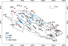
图1
祁连山区流域及气象站点分布示意图"

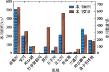
图2
祁连山各流域冰川统计"

表1
国家气象站站点信息"
| 站点 | 纬度(N) | 经度(E) | 海拔/m | 流域 |
|---|---|---|---|---|
| 玉门 | 40°16′12″ | 97°1′47″ | 1527 | 疏勒河 |
| 野牛沟 | 38°25′12″ | 99°34′48″ | 3320 | 黑河、青海湖 |
| 乌鞘岭 | 37°12′ | 102°52′12″ | 3044 | 石羊河 |
| 大柴旦 | 37°51′ | 95°22′12" | 3174 | 哈拉湖、巴音郭勒河、鱼卡-塔塔棱、哈尔腾河 |
| 酒泉 | 39°46′12" | 98°28′48" | 1478 | 北大河 |
| 门源 | 37°22′48" | 101°37′12" | 2851 | 大通河 |
| 冷湖 | 38°45′ | 93°19′48" | 2770 | 党河 |
表2
度日因子、正积温随海拔的递减率"
| 流域 | 递减率 | |
|---|---|---|
| 度日 因子 | 疏勒河流域与其他流域 | -0.0293Ele+147.97 |
| 北大河流域 | -0.0309Ele+147.97 | |
| 正积温 | 中段(青海湖和黑河流域) | -1.02 ℃·m-1 |
| 东段(石羊河流域和大通河流域) | -1.15 ℃· m-1 | |
| 西段(其他流域) | -1.08 ℃· m-1 |
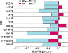
图3
祁连山及各流域不同阶段的年平均物质平衡"

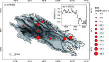
图4
1961—2013年祁连山冰川物质平衡时空变化"

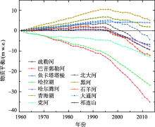
图5
1961—2013年祁连山冰川累积物质平衡变化"


图6
1961—2013年祁连山冰川物质平衡及正积温和降水的年代际变化"
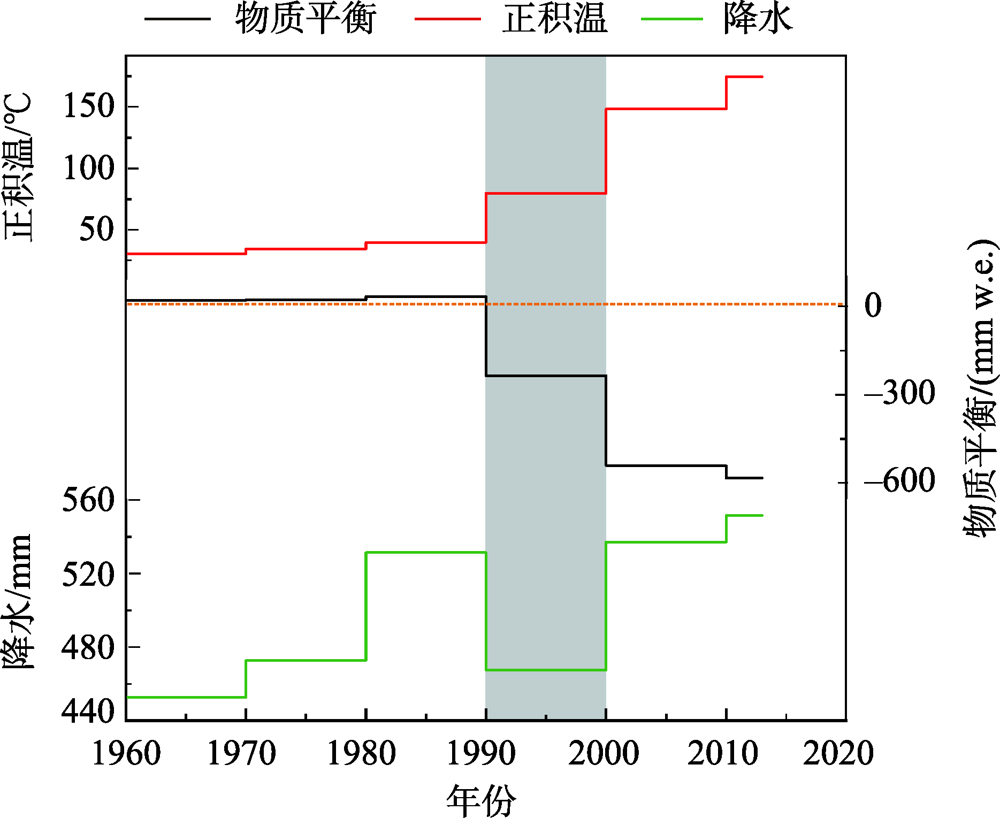
表3
1961—2013年各流域冰川区正积温、降水和物质平衡的变化率"
| 流域 | 降水变化率 /(mm·a-1) | 正积温变化率 /(℃·a-1) | 物质平衡变化率 /(mm w.e.·a-1) |
|---|---|---|---|
| 疏勒河 | 2.12 | 1.76 | -17.0 |
| 青海湖 | 2.20 | 1.99 | -16.3 |
| 鱼卡塔塔棱 | 2.04 | 4.58 | -3.9 |
| 哈拉湖 | 2.09 | 5.30 | -15.5 |
| 黑河 | 1.89 | 0.64 | -12.1 |
| 巴音郭勒河 | 1.88 | 7.71 | -24.9 |
| 党河 | 2.19 | 1.63 | -7.0 |
| 北大河 | 1.99 | 3.75 | -16.7 |
| 哈尔腾河 | 2.13 | 5.68 | -12.2 |
| 石羊河 | 1.45 | 0.97 | -20.9 |
| 大通河 | 1.38 | 1.16 | -19.3 |
| 祁连山 | 1.94 | 3.20 | -14.9 |
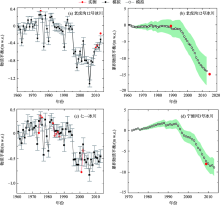
图7
典型冰川物质平衡模拟与实测对比"

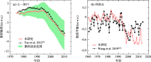
图8
本研究与已有研究的物质平衡重建结果对比"

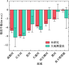
图9
2000—2010年本研究与大地测量法计算的物质平衡结果对比"

| [1] | 张国飞. 中国天山乌鲁木齐河源 1 号冰川物质平衡及其与气候变化关系研究[D]. 兰州: 西北师范大学, 2014. |
| [ Zhang Guofei. Study on Mass Balance and Its Rrelationship with Climate Change of Urumqi Glacier No. 1 in Tianshan Mountains, China[D]. Lanzhou: Northwest Normal University, 2014. ] | |
| [2] | Kaser G, Fountain A, Jansson P. A Manual for Monitoring the Mass Balance of Mountain Glaciers[M]. Paris: Unesco, 2003. |
| [3] |
Aizen V B, Kuzmichenok V A, Surazakov A B, et al. Glacier changes in the central and northern Tien Shan during the last 140 years based on surface and remote-sensing data[J]. Annals of Glaciology, 2006, 43:202-213.
doi: 10.3189/172756406781812465 |
| [4] |
Aizen V B, Kuzmichenok V A, Surazakov A B, et al. Glacier changes in the Tien Shan as determined from topographic and remotely sensed data[J]. Global and Planetary Change, 2007, 56(3-4):328-340.
doi: 10.1016/j.gloplacha.2006.07.016 |
| [5] | Braithwaite R J, Raper S C B, Candela R. Recent changes (1991-2010) in glacier mass balance and air temperature in the European Alps[J]. Annals of Glaciology, 2013, 54(63):139-146. |
| [6] | 王盼盼, 李忠勤, 王璞玉, 等. 北极山地冰川物质平衡变化及其对气候的响应[J]. 干旱区研究, 2020, 37(5):1205-1214. |
| [ Wang Panpan, Li Zhongqin, Wang Puyu, et al. Changes in the mass of Arctic Alpine glacier and its response to climate change[J]. Arid Zone Research, 2020, 37(5):1205-1214. ] | |
| [7] |
Yao T, Thompson L, Yang W, et al. Different glacier status with atmospheric circulations in Tibetan Plateau and surroundings[J]. Nature climate change, 2012, 2(9):663-667.
doi: 10.1038/nclimate1580 |
| [8] |
Schaner N, Voisin N, Nijssen B, et al. The contribution of glacier melt to streamflow[J]. Environmental Research Letters, 2012, 7(3):034029.
doi: 10.1088/1748-9326/7/3/034029 |
| [9] |
Radić V, Bliss A, Beedlow A C, et al. Regional and global projections of twenty-first century glacier mass changes in response to climate scenarios from global climate models[J]. Climate Dynamics, 2014, 42(1-2):37-58.
doi: 10.1007/s00382-013-1719-7 |
| [10] |
Braithwaite R J, Zhang Y. Modelling changes in glacier mass balance that may occur as a result of climate changes[J]. Geografiska Annaler: Series A, Physical Geography, 1999, 81(4):489-496.
doi: 10.1111/geoa.1999.81.issue-4 |
| [11] | 杨针娘. 祁连山冰川水资源[J]. 冰川冻土, 1988, 4(1):36-46. |
| [ Yang Zhenniang. Glacier water resources in Qilian Mountains[J]. Journal of Glaciology and Geocryology, 1988, 4(1):36-46. ] | |
| [12] | 曹泊, 潘保田, 高红山, 等. 1972—2007 年祁连山东段冷龙岭现代冰川变化研究[J]. 冰川冻土, 2010, 32(2):242-248. |
| [ Cao Bo, Pan Baotian, Gao Hongshan, et al. Glacier variation in the Lenglongling rang of eastern Qilian Mountains from 1972 to 2007[J]. Journal of Glaciology and Geocryology, 2010, 32(2):242-248. ] | |
| [13] | 刘宇硕, 秦翔, 张通, 等. 祁连山东段冷龙岭地区宁缠河 3 号冰川变化研究[J]. 冰川冻土, 2012, 34(5):1031-1036. |
| [ Liu Yushuo, Qin Xiang, Zhang Tong, et al. Variation of the Ningchanhe River Glacier No. 3 in the Lenglongling range. East Qilian Mountains[J]. Journal of Glaciology and Geocryology, 2012, 34(5):1031-1036. ] | |
| [14] | 蒲健辰, 姚檀栋, 段克勤, 等. 祁连山七一冰川物质平衡的最新观测结果[J]. 冰川冻土, 2005, 27(2):199-204. |
| [ Pu Jianchen, Yao Tandong, Duan Keqin, et al. Mass balance of the Qiyi Glacier in the Qilian Mountains: A new observation[J]. Journal of Glaciology and Geocryology, 2005, 27(2):199-204. ] | |
| [15] |
Zhang Y, Liu S, Shangguan D, et al. Thinning and shrinkage of Laohugou No. 12 glacier in the Western Qilian Mountains, China, from 1957 to 2007[J]. Journal of Mountain Science, 2012, 9(3):343-350.
doi: 10.1007/s11629-009-2296-4 |
| [16] | 徐春海, 李忠勤, 王飞腾, 等. 基于LiDAR, SRTM DEM 的祁连山黑河流域十一冰川 2000—2012 年物质平衡估算[J]. 自然资源学报, 2017, 32(1):88-100. |
| [ Xu Chunhai, Li Zhongqin, Wang Feiteng, et al. Estimation of mass balance of Shiyi Glacier in the Heihe River Basin, Qilian Mountains during 2000-2012 based on LiDAR and SRTM DEM[J]. Journal of Natural Resources, 2017, 32(1):88-100. ] | |
| [17] | 方潇雨, 李忠勤, 高抒, 等. 冰川物质平衡模式及其对比研究——以祁连山黑河流域十一冰川研究为例[J]. 冰川冻土, 2015, 37(2):336-350. |
| [ Fang Xiaoyu, Li Zhongqin, Gao Shu, et al. Physical energy-balance and statistical glacier melting models comparison and testing for Shiyi Glacier, Heihe River Basin, Qilian Mountains, China[J]. Journal of Glaciology and Geocryology, 2015, 37(2):336-350. ] | |
| [18] | 别强, 强文丽, 王超, 等. 1960—2010年黑河流域冰川变化的遥感监测[J]. 冰川冻土, 2013, 35(3):574-582. |
| [ Bie Qiang, Qiang Wenli, Wang Chao, et al. Monitoring glacier variation in the upper reaches of the Heihe River based on remote sensing in 1960-2010[J]. Journal of Glaciology and Geocryology, 2013, 35(3):574-582. ] | |
| [19] | 陈辉, 李忠勤, 王璞玉, 等. 近年来祁连山中段冰川变化[J]. 干旱区研究, 2013, 30(4):588-593. |
| [ Chen Hui, Li Zhongqin, Wang Puyu, et al. Change of glaciers in the central Qilian Mountain[J]. Arid Zone Research, 2013, 30(4):588-593. ] | |
| [20] |
Shangguan D, Liu S, Ding Y, et al. Changes in the elevation and extent of two glaciers along the Yanglonghe River, Qilian Shan, China[J]. Journal of Glaciology, 2010, 56(196):309-317.
doi: 10.3189/002214310791968566 |
| [21] | 刘时银, 沈永平, 孙文新, 等. 祁连山西段小冰期以来的冰川变化研究[J]. 冰川冻土, 2012, 24(3):227-233. |
| [ Liu Shiyin, Shen Yongping, Sun Wenxin, et al. Glacier variation since the maximum of the little ice age in the western Qilian Mountains, Northwest China[J]. Journal of Glaciology and Geocryology, 2012, 24(3):227-233. ] | |
| [22] |
孙美平, 刘时银, 姚晓军, 等. 近 50 年来祁连山冰川变化——基于中国第一, 二次冰川编目数据[J]. 地理学报, 2015, 70(9):1402-1414.
doi: 10.11821/dlxb201509004 |
|
[ Sun Meiping, Liu Shiyin, Yao Xiaojun, et al. Glacier changes in the Qilian Mountains in the past half century: Based on the revised first and second Chinese glacier inventory[J]. Acta Geographica Sinica, 2015, 70(9):1402-1414. ]
doi: 10.11821/dlxb201509004 |
|
| [23] | 高永鹏, 姚晓军, 安丽娜, 等. 2000—2010年祁连山冰川冰储量变化[J]. 干旱区研究, 2018, 35(2):325-333. |
| [ Gao Yongpeng, Yao Xiaojun, An Lina, et al. Change of ice volume in the Qilian Mountains during the period from 2000 to 2010[J]. Arid Zone Research, 2018, 35(2):325-333. ] | |
| [24] | 高鑫, 张世强, 叶柏生, 等. 河西内陆河流域冰川融水近期变化[J]. 水科学进展, 2011, 22(3):344-350. |
| [ Gao Xin, Zhang Shiqiang, Ye Baisheng, et al. Recent changes of glacier runoff in the Hexi Inland river basin[J]. Advances in Water Science, 2011, 22(3):344-350. ] | |
| [25] |
Wang R, Liu S, Shangguan D, et al. Spatial heterogeneity in glacier mass-balance sensitivity across high Mountain Asia[J]. Water, 2019, 11(4):776.
doi: 10.3390/w11040776 |
| [26] | 王盛, 蒲健辰, 王宁练. 祁连山七一冰川物质平衡及其对气候变化的敏感性研究[J]. 冰川冻土, 2012, 33(6):1214-1221. |
| [ Wang Sheng, Pu Jianchen, Wang Ninglian. Study of mass balance and sensibility to climate change of Qiyi glacier in Qilian Mountains[J]. Journal of Glaciology and Geocryology, 2012, 33(6):1214-1221. ] | |
| [27] |
Hock R. Temperature index melt modelling in mountain areas[J]. Journal of Hydrology, 2003, 282(1):104-115.
doi: 10.1016/S0022-1694(03)00257-9 |
| [28] | 康世昌, 郭万钦, 吴通华, 等. “一带一路”区域冰冻圈变化及其对水资源的影响[J]. 地球科学进展, 2020, 35(1):1-17. |
| [ Kang Shichang, Guo Wanqin, Wu Tonghua, et al. Cryospheric changes and their impacts on water resources in the Belt and Road Regions[J]. Advances in Earth Science, 2020, 35(1):1-17. ] | |
| [29] | 尤联元, 杨景春. 中国地貌[M]. 北京: 科学出版社, 2013. |
| [ You Lianyuan, Yang Jingchun. Geomor phology of China[M]. Beijing: Science Press, 2013. ] | |
| [30] | 伍光和, 谢自楚, 黄茂桓, 等. 祁连山现代冰川基本特征研究[J]. 兰州大学学报, 1980, 24(3):127-134. |
| [ Wu Guanghe, Xie Zichu, Huang Maohuan, et al. Study on the principal of present glaciers in Qilianshan[J]. Journal of Lanzhou University, 1980, 24(3):127-134. ] | |
| [31] |
刘时银, 姚晓军, 郭万钦, 等. 基于第二次冰川编目的中国冰川现状[J]. 地理学报, 2015, 70(1):3-16.
doi: 10.11821/dlxb201501001 |
|
[ Liu Shiyin, Yao Xiaojun, Guo Wanqin, et al. The contemporary glaciers in China based on the second Chinese glacier inventory[J]. Acta Geographica Sinica, 2015, 70(1):3-16. ]
doi: 10.11821/dlxb201501001 |
|
| [32] | Huintjes E, Li H, Sauter T, et al. Degree-day modelling of the surface mass balance of Urumqi Glacier No. 1, Tian Shan, China[J]. The Cryosphere Discussions, 2010, 4(1):207-232. |
| [33] |
Kumar L, Skidmore A K, Knowles E. Modelling topographic variation in solar radiation in a GIS environment[J]. International Journal of Geographical Information Science, 1997, 11(5):475-497.
doi: 10.1080/136588197242266 |
| [34] | Gates D M. Biophysical Ecology[M]. New York: Dover Publications, 2012. |
| [35] | Kreith F, Kreider J F. Principles of Solar Engineering[M]. Washington: Taylor & Francis, 1978. |
| [36] | Liu B Y H, Jordan R C. The interrelationship and characteristic distribution of direct, diffuse and total solar radiation[J]. Solar Energy, 1960, 4(3):1-19. |
| [37] | 刘时银, 郭万钦, 许君利. 中国第二次冰川编目数据集[DB/OL]. 国家冰川冻土沙漠科学数据中心, 2019. |
| [ Liu Shiyin, Guo Wanqin, Xu Junli. The Second Glacial Catalogue Data Set of China[DB/OL]. National Cryosphere Desert Data Center, 2019. ] | |
| [38] |
Chen R, Liu J, Kang E, et al. Precipitation measurement intercomparison in the Qilian Mountains, north-eastern Tibetan Plateau[J]. The Cryosphere, 2015, 9(5):1995-2008.
doi: 10.5194/tc-9-1995-2015 |
| [39] |
Chen R S, Song Y X, Kang E S, et al. A cryosphere-hydrology observation system in a small alpine watershed in the Qilian Mountains of China and its meteorological gradient[J]. Arctic, Antarctic, and Alpine Research, 2014, 46(2):505-523.
doi: 10.1657/1938-4246-46.2.505 |
| [40] |
陈仁升, 刘俊峰. 中国高寒山区月降水数据集(CAPD)(1954—2014)[DB/OL]. 国家青藏高原科学数据中心, 2017. DOI: 10.3990/CAPD.306.2016.db.
doi: 10.3990/CAPD.306.2016.db |
|
[ Chen Rensheng, Liu Junfeng. China Alpine Region Month Precipitation Dataset (CAPD) (1954-2014)[DB/OL]. National Tibetan Plateau Data Center, 2017. DOI: 10.3990/CAPD.306.2016.db.]
doi: 10.3990/CAPD.306.2016.db |
|
| [41] | Han C, Chen R, Liu Z, et al. Cryospheric hydrometeorology observation in the Hulu catchment (CHOICE), Qilian mountains, China[J]. Vadose Zone Journal, 2018, 17(1):1-18. |
| [42] | 刘宇硕, 秦翔, 张通, 等. 祁连山东段冷龙岭地区宁缠河 3 号冰川变化研究[J]. 冰川冻土, 2012, 34(5):1031-1036. |
| [ Liu Yushuo, Qin Xiang, Zhang Tong, et al. Variation of the Ningchan River glacier No.3 in the Lenglongling rang, East Qilian Mountains[J]. Journal of Glaciology and Geocryology, 2012, 34(5):1031-1036. ] | |
| [43] |
Zhang X, Qin X, Xu C, et al. Simulation of runoff and glacier mass balance and sensitivity analysis in a glacierized basin, north-eastern Qinhai-Tibetan Plateau, China[J]. Water, 2018, 10(9):1259.
doi: 10.3390/w10091259 |
| [44] |
Azam M F, Wagnon P, Vincent C, et al. Reconstruction of the annual mass balance of Chhota Shigri glacier, Western Himalaya, India, since 1969[J]. Annals of Glaciology, 2014, 55(66):69-80.
doi: 10.3189/2014AoG66A104 |
| [45] |
Cong Z, Kang S, Gao S, et al. Historical trends of atmospheric black carbon on Tibetan Plateau as reconstructed from a 150-year lake sediment record[J]. Environmental Science & Technology, 2013, 47(6):2579-2586.
doi: 10.1021/es3048202 |
| [1] | 李永广, 苑广辉. 青海湖流域不同下垫面类型对地表温度的生物物理影响[J]. 干旱区研究, 2024, 41(1): 24-35. |
| [2] | 康文辉,周殷竹,孙英,周金龙,曹月婷,鲁涵,涂治. 新疆玛纳斯河流域地下水砷氟分布及共富集成因[J]. 干旱区研究, 2023, 40(9): 1425-1437. |
| [3] | 孙茂森,王让会,宁虎森. 阿克苏河流域生态网络构建[J]. 干旱区研究, 2023, 40(9): 1509-1516. |
| [4] | 孙冰清,杜加强,毛佳琳,张静,盛芝露,张杨成思. 基于生态资产的湟水流域生态保护效益评估[J]. 干旱区研究, 2023, 40(9): 1517-1526. |
| [5] | 张晓敏, 张东梅, 张伟. 人类活动对额尔齐斯河流域碳储量的影响[J]. 干旱区研究, 2023, 40(8): 1333-1345. |
| [6] | 王士维, 孙栋元, 周敏, 王亦可, 王祥镔, 季宗虎, 张文睿, 武兰珍. 1951—2020年疏勒河流域气温时空变化特征[J]. 干旱区研究, 2023, 40(7): 1065-1074. |
| [7] | 杜慧娟, 王光耀, 冉光妍, 吕密. 面向SDGs的塔里木河流域农业灰水足迹分析[J]. 干旱区研究, 2023, 40(7): 1184-1193. |
| [8] | 齐润泽, 潘竟虎. 河湟地区生态脆弱性时空演变及影响因素研究[J]. 干旱区研究, 2023, 40(6): 1002-1013. |
| [9] | 邹易, 蒙吉军. 干旱区绿洲-城镇-荒漠景观演变及生态环境效应[J]. 干旱区研究, 2023, 40(6): 988-1001. |
| [10] | 任丽雯, 王兴涛, 刘明春, 王大为. 石羊河流域植被净初级生产力时空变化及驱动因素[J]. 干旱区研究, 2023, 40(5): 818-828. |
| [11] | 闫豫疆, 李建贵, 李均力, 蒋腾. 面向生态系统服务供需的开都-孔雀河流域生态安全格局研究[J]. 干旱区研究, 2023, 40(5): 829-839. |
| [12] | 段雨佳, 何毅, 赵杰, 吴琼. 人类活动对秦岭月河流域径流变化的影响分析[J]. 干旱区研究, 2023, 40(4): 605-614. |
| [13] | 邱巡巡, 曹广超, 张进虎, 张卓, 刘梦琳. 祁连山南坡青海云杉林碳密度随海拔分布特征[J]. 干旱区研究, 2023, 40(4): 615-622. |
| [14] | 王嘉川, 李书恒, 郭伊利, 韩宜洁, 毛忠雷. 树轮记录的吕梁山北段1923年以来3—4月平均最高气温变化[J]. 干旱区研究, 2023, 40(3): 337-348. |
| [15] | 康利刚, 曹生奎, 曹广超, 杨羽帆, 严莉, 王有财. 青海湖沙柳河流域蒸散发时空变化特征[J]. 干旱区研究, 2023, 40(3): 358-372. |
|
||