干旱区研究 ›› 2022, Vol. 39 ›› Issue (3): 774-786.doi: 10.13866/j.azr.2022.03.11 cstr: 32277.14.AZR.20220311
文广超( ),李兴,吴冰洁,王晓鹤,谢洪波
收稿日期:2021-08-30
修回日期:2021-10-06
出版日期:2022-05-15
发布日期:2022-05-30
作者简介:文广超(1979-),男,博士,副教授,主要从事流域水文过程与生态环境保护、地学信息技术与“3S”集成应用等方面的教学与科 研工作. E-mail: 基金资助:
WEN Guangchao(),LI Xing,WU Bingjie,WANG Xiaohe,XIE Hongbo
Received:2021-08-30
Revised:2021-10-06
Published:2022-05-15
Online:2022-05-30
摘要:
柴达木盆地内的湖泊对维系区域生态平衡、满足生产及生活用水、保护生态环境具有重要的作用。随着区域气候变化和人类活动影响的增强,盆地内湖泊格局发生了一系列变化,为了分析湖泊变化特征,查明变化原因,以快速、精确、适用性强为目标,基于Landsat系列遥感影像,通过分析可鲁克湖流域湖泊水体TOA(Top-of-atmosphere)反射率与其他地物TOA反射率的差异,提出了一种湖泊水体自动提取方法——湖泊水体差分模型。利用该模型处理了柴达木盆地的近百个Landsat图像场景,提取了不同时间节点、不同空间位置的湖泊水体,使用总体分类精度、Kappa系数及用户精度对其精度进行评价,并与NDWI(Normalized Difference Water Index)、MNDWI(Modified Normalized Difference Water Index)方法对该地区湖泊水体提取结果进行了比较分析。结果表明:(1) 利用TOA反射率差异,可区分目标与非目标地物;(2) 基于稳定的阈值,湖泊水体差分模型可实现湖泊水体信息快速提取,与NDWI、MNDWI等水体信息提取方法相比,能够更加有效抑制地表河流、冰雪、阴影、沼泽湿地等干扰因素,在模型应用的区域内,平均总体分类精度与用户精度均达到99%以上,Kappa达到0.9877;(3) 湖泊水体差分模型的输入数据既可以是TOA反射率,也可以是Landsat(Level-2)的地表反射率数据;(4) 湖泊水体差分模型适用于柴达木盆地内大范围区域的湖泊水体提取,能够为湖泊水体动态变化规律研究提供技术支持。
文广超,李兴,吴冰洁,王晓鹤,谢洪波. 基于Landsat影像的柴达木盆地湖泊提取方法[J]. 干旱区研究, 2022, 39(3): 774-786.
WEN Guangchao,LI Xing,WU Bingjie,WANG Xiaohe,XIE Hongbo. An automatic method for delineating lake surfaces in Qaidam Basin using Landsat images[J]. Arid Zone Research, 2022, 39(3): 774-786.
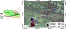
图1
研究区位置及采样点分布"

表1
所用部分遥感影像基本信息"
| 地区 | 传感器 | 日期/年-月-日 | 条带号 | 行号 | 云量/% |
|---|---|---|---|---|---|
| 可鲁克湖 | TM | 2000-04-10 | 135 | 34 | 13.45 |
| 可鲁克湖 | ETM+ | 2002-04-08 | 135 | 34 | 3 |
| 可鲁克湖 | OLI | 2016-07-27 | 135 | 34 | 2.36 |
| 小柴旦湖 | TM | 2004-06-15 | 136 | 34 | 0.79 |
| 尕斯库勒湖 | TM | 2002-05-14 | 139 | 34 | 14.42 |
| 青海湖 | OLI | 2018-07-19 | 133 | 34 | 20.49 |
| 察尔汗盐湖 | OLI | 2020-04-08 | 136 | 34 | 6.88 |
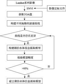
图2
湖泊水体信息提取模型建立的技术路线 注:Blue为蓝光;Green为绿光;Red为红光;NIR为近红外;SWIR1为短波红外1;SWIR2为短波红外2。"


图3
研究区6种地类的波谱曲线 注:Blue为蓝光;Green为绿光;Red为红光;NIR为近红外;SWIR1为短波红外1;SWIR2为短波红外2。"
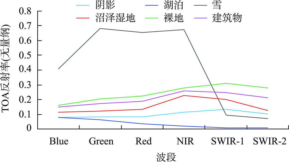
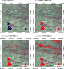
图4
可鲁克湖区域湖泊水体提取结果"

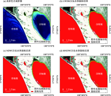
图5
青海湖区域湖泊水体提取结果"


图6
青海湖区域LWDM方法水体局部提取结果"
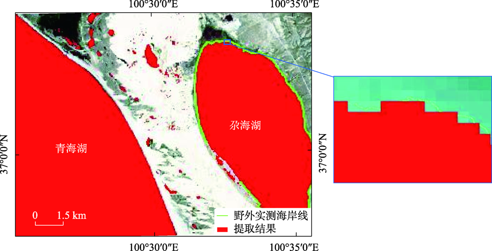
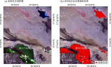
图7
察尔汗盐湖水体提取结果"

表2
湖泊水体信息提取精度评价结果"
| 试验区域 | 传感器 | 成像时间/年-月-日 | 方法 | OA/% | Kappa | 用户精度/% |
|---|---|---|---|---|---|---|
| 可鲁克湖 | TM | 2000-04-10 | LWDM | 99.65 | 0.9958 | 99.39 |
| 可鲁克湖 | ETM+ | 2002-04-08 | 99.43 | 0.9932 | 100 | |
| 可鲁克湖 | OLI | 2016-07-27 | 99.87 | 0.9987 | 99.47 | |
| 小柴旦湖 | TM | 2004-06-15 | 99.65 | 0.9948 | 100 | |
| 尕斯库勒湖 | TM | 2002-05-14 | 99.91 | 0.9988 | 99.65 | |
| 青海湖 | OLI | 2018-07-19 | 99.87 | 0.9984 | 99.20 | |
| 察尔汗盐湖 | OLI | 2020-04-08 | 97.98 | 0.9339 | 99.94 | |
| 平均值 | 99.48 | 0.9877 | 99.66 | |||
| 可鲁克湖 | TM | 2000-04-10 | NDWI | 95.42 | 0.9450 | 79.12 |
| 可鲁克湖 | ETM+ | 2002-04-08 | 95.07 | 0.9409 | 77.18 | |
| 可鲁克湖 | OLI | 2016-07-27 | 97.83 | 0.9728 | 90.20 | |
| 小柴旦湖 | TM | 2004-06-15 | 95.60 | 0.9340 | 88.34 | |
| 尕斯库勒湖 | TM | 2002-05-14 | 96.38 | 0.9517 | 87.34 | |
| 青海湖 | OLI | 2018-07-19 | 99.63 | 0.9956 | 97.84 | |
| 察尔汗盐湖 | OLI | 2020-04-08 | 96.27 | 0.7363 | 99.89 | |
| 平均值 | 96.60 | 0.9252 | 88.56 | |||
| 可鲁克湖 | TM | 2000-04-10 | MNDWI | 77.67 | 0.7320 | 42.74 |
| 可鲁克湖 | ETM+ | 2002-04-08 | 64.77 | 0.5773 | 32.12 | |
| 可鲁克湖 | OLI | 2016-07-27 | 96.80 | 0.9599 | 86.19 | |
| 小柴旦湖 | TM | 2004-06-15 | 65.74 | 0.4861 | 49.31 | |
| 尕斯库勒湖 | TM | 2002-05-14 | 71.10 | 0.6147 | 46.38 | |
| 青海湖 | OLI | 2018-07-19 | 91.10 | 0.8932 | 65.19 | |
| 察尔汗盐湖 | OLI | 2020-04-08 | 96.27 | 0.7301 | 89.91 | |
| 平均值 | 80.49 | 0.7133 | 58.83 |
表3
滇池、太湖、天池湖泊水体信息提取精度评价结果"
| 实验区域 | 传感器 | 成像时间/年-月-日 | 方法 | OA/% | Kappa | 用户精度/% |
|---|---|---|---|---|---|---|
| 滇池 | OLI | 2021-03-25 | LWDM | 90.13 | 0.6295 | 89.86 |
| 太湖 | OLI | 2021-06-23 | 96.03 | 0.8185 | 96.32 | |
| 天池 | OLI | 2021-06-18 | 99.79 | 0.9413 | 99.82 |
| [1] | 曹国亮, 李天辰, 陆垂裕, 等. 基于遥感的湖泊水域动态变化监测研究进展[J]. 遥感技术与应用, 2009, 24(5): 674-684. |
| [ Cao Guoling, Li Tianchen, Lu Chuiyu, et al. Dynamic variation and evaporation of seasonal lakes in arid areas: A case study for the Aiding Lake[J]. Arid Zone Research, 2020, 37(5): 674-684. ] | |
| [2] | 杨桂山, 马荣华, 张路, 等. 中国湖泊现状及面临的重大问题与保护策略[J]. 湖泊科学, 2010, 22(6): 799-810. |
| [ Yang Guishan, Ma Ronghua, Zhang Lu, et al. Lake status, major problems and protection strategy in China[J]. Journal of Lake Sciences, 2010, 22(6): 799-810. ] | |
| [3] | 卢娜. 柴达木盆地湖泊面积变化及影响因素分析[J]. 干旱区资源与环境, 2014, 28(8): 83-87. |
| [ Lu Na. Changes of lake area in Qaidam basin and the influence factors[J]. Journal of Arid Land Resources and Environment, 2014, 28(8): 83-87. ] | |
| [4] | 王永贵, 李义民, 刘丽峰, 等. 对柴达木盆地形成过程的初步探讨[J]. 青海科技, 2007, 14(5): 24-26. |
| [ Wang Yonggui, Li Yimin, Liu Lifeng, et al. Preliminary discussion on the formation process of the Qaidam Basin[J]. Qinghai Science and Technology, 2007, 14(5): 24-26. ] | |
| [5] |
董斯扬, 薛娴, 尤全刚, 等. 近40年青藏高原湖泊面积变化遥感分析[J]. 湖泊科学, 2014, 26(4): 535-544.
doi: 10.18307/2014.0407 |
|
[ Dong Siyang, Xue Xian, You Quangang, et al. Remote sensing monitoring of the lake area changes in the Qinghai-Tibet Plateau in recent 40 years[J]. Journal of Lake Sciences, 2014, 26(4) : 535-544. ]
doi: 10.18307/2014.0407 |
|
| [6] | 胡争光, 王祎婷, 池天河, 等. 基于混合像元分解和双边界提取的湖泊面积变化监测[J]. 遥感信息, 2007(3): 34-38. |
| [ Hu Zhengguang, Wang Yiting, Chi Tianhe, et al. Monitoring lake areas based on mixed pixel decomposition combined with double-edge extraction[J]. Remote Sensing Information, 2007(3): 34-38. ] | |
| [7] |
段水强. 1976-2015年柴达木盆地湖泊演变及其对气候变化和人类活动的响应[J]. 湖泊科学, 2018, 30(1): 256-265.
doi: 10.18307/2018.0125 |
|
[ Duan Shuiqiang. Lake evolution in the Qaidam Basin during 1976-2015 and their changes in response to climate and anthropogenic factors[J]. Journal of Lake Sciences, 2018, 30(1): 256-265. ]
doi: 10.18307/2018.0125 |
|
| [8] | 丁永建, 刘时银, 叶柏生, 等. 近50 a中国寒区与旱区湖泊变化的气候因素分析[J]. 冰川冻土, 2006, 28(5): 623-632. |
| [ Ding Yongjian, Liu Shiyin, Ye Bosheng, et al. Climatic implications on variations of lakes in the cold and arid regions of China during the recent 50 years[J]. Journal of Glaciology and Geocryology, 2006, 28(5): 623-632. ] | |
| [9] | 张超, 韩琳, 陈亮. 柴达木盆地湖泊水面变化遥感监测分析[J]. 人民黄河, 2010, 32(12): 54-55. |
| [ Zhang Chao, Han Lin, Chen Liang. Remote sensing monitoring and analysis of lake surface changes in Qaidam Basin[J]. Yellow River, 2010, 32(12): 54-55. ] | |
| [10] |
徐浩杰, 杨太保. 1981-2010年柴达木盆地气候要素变化特征及湖泊和植被响应[J]. 地理科学进展, 2013, 32(6): 868-879.
doi: 10.11820/dlkxjz.2013.06.003 |
|
[ Xu Haojie, Yang Taibao. Climate factors change and its impact on lake area and vegetation growth in the Qaidam Basin during 1981-2010[J]. Progress in Geography, 2013, 32(6): 868-879. ]
doi: 10.11820/dlkxjz.2013.06.003 |
|
| [11] | 魏善蓉, 金晓媚, 王凯霖, 等. 基于遥感的柴达木盆地湖泊面积变化与气候响应分析[J]. 地学前缘, 2017, 24(5): 427-433. |
| [ Wei Shanrong, Jin Xiaomei, Wang Kailin, et al. Response of lake area variation to climate change in Qaidam Basin based on remote sensing[J]. Earth Science Frontiers, 2017, 24(5): 427-433. ] | |
| [12] |
Jiang H, Feng M, Zhu Y, et al. An automated method for extracting rivers and lakes from landsat imagery[J]. Remote Sensing, 2014, 6(6): 5067-5089.
doi: 10.3390/rs6065067 |
| [13] |
Olmanson L G, Bauer M E, Brezonik P L. A 20-year landsat water clarity census of Minnesota’s 10000 lakes[J]. Remote Sensing of Environment, 2008, 112(11): 4086-4097.
doi: 10.1016/j.rse.2007.12.013 |
| [14] |
Li W, Du Z, Ling F, et al. A comparison of land surface water mapping using the normalized difference water index from TM, ETM+ and ALI[J]. Remote Sensing, 2013, 5(11): 5530-5549.
doi: 10.3390/rs5115530 |
| [15] |
Mcfeeters S K. Using the Normalized Difference Water Index (NDWI) within a geographic information system to detect swimming pools for mosquito abatement: A practical approach[J]. Remote Sensing, 2013, 5(7): 3544-3561.
doi: 10.3390/rs5073544 |
| [16] |
黄帅, 宋开宏, 罗菊花, 等. 基于梯度变换的浅水湖泊围网区遥感提取算法[J]. 湖泊科学, 2017, 29(2): 490-497.
doi: 10.18307/2017.0225 |
|
[ Huang Shuai, Song Kaihong, Luo Juhua, et al. A remote sensing extraction algorithm of enclosure culture area in shallow lakes based on gradient transform[J]. Journal of Lake Sciences, 2017, 29(2): 490-497. ]
doi: 10.18307/2017.0225 |
|
| [17] | Jupp D L B, Mayo K K, Kucher D. A. et al. Landsat Based Interpretation of the Cairns Section of the Great Barrier Reef Marine Park[R]. CSIRO Division of Water & amp; Land Resources, 1985. |
| [18] | 陆家驹, 李士鸿. TM资料水体识别技术的改进[J]. 环境遥感, 1992, 7(1): 17-23. |
| [ Lu Jiaju, Li Shihong. Improvement of the techniques for distinguishing water bodies from TM data[J]. Environmental Remote Sensing 1992, 7(1): 17-23. ] | |
| [19] |
McFeeters S K. The use of the Normalized Difference Water Index (NDWI) in the delineation of open water features[J]. International Journal of Remote Sensing, 1996, 17(7): 1425-1432.
doi: 10.1080/01431169608948714 |
| [20] | 杨存建, 徐美, 黄朝远, 等. 遥感信息机理的水体提取方法的探讨[J]. 地理研究, 1998, 17(增刊): 86-89. |
| [ Yang Cunjian, Xu Mei, Huang Chaoyuan, et al. Approaches of water extraction based on remote sensing[J]. Geographical Research, 1998, 17(Suppl.): 86-89. ] | |
| [21] | 徐涵秋. 利用改进的归一化差异水体指数(MNDWI)提取水体信息的研究[J]. 遥感学报, 2005, 9(5): 589-595. |
| [ Xu Hanqiu. A study on information extraction of water body with the Modified Difference Water Index(MNDWI)[J]. National Remote Sensing Bulletin, 2005, 9(5): 589-595. ] | |
| [22] | 闫霈, 张友静, 张元. 利用增强型水体指数(EWI)和GIS去噪音技术提取半干旱地区水系信息的研究[J]. 遥感信息, 2007(6): 62-67. |
| [ Yan Pei, Zhang Youjing, Zhang Yuan. A study on information extraction of water system in semi-arid regions with the Enhanced Water Index(EWI) and GIS based noise remove techniques[J]. Remote Sensing Information, 2007(6): 62-67. ] | |
| [23] | 丁凤. 基于新型水体指数(NWI)进行水体信息提取的实验研究[J]. 测绘科学, 2009, 34(4): 155-157. |
| [ Ding Feng. Study on information extraction of water body with a New Water Index(NWI)[J]. Science of Surveying & Mapping, 2009, 34(4): 155-157. ] | |
| [24] | 王晴晴, 余明. 基于简单比值型水体指数(SRWI)的水体信息提取研究[J]. 福建师范大学学报(自然科学版), 2014, 30(1): 39-44. |
| [ Wang Qingqing, Yu Ming. Study on information extraction of water body based on Simple Ratio of Water Index (SRWI)[J]. Journal of Fujian Normal University (Natural Science Edition), 2014, 30(1): 39-44. ] | |
| [25] | 丁占峰, 李大军. 基于ONDWI水体指数的鄱阳湖水域信息提取[J]. 安徽农业科学, 2015, 43(6): 348-350. |
| [ Ding Zhanfeng, Li Dajun. The water region extraction of the Poyang Lake based on the ONDWI[J]. Journal of Anhui Agricultural Sciences, 2015, 6(6): 348-350. ] | |
| [26] |
朱金峰, 王乃昂, 李卓仑, 等. 巴丹吉林沙漠湖泊季节变化的遥感监测[J]. 湖泊科学, 2011, 23(4): 657-664.
doi: 10.18307/2011.0424 |
|
[ Zhu Jinfeng, Wang Nai’ang, Li Zhuolun, et al. RS-based monitoring seasonal changes of lake in Badain Jaran Desert[J]. Journal of Lake Sciences, 2011, 23(4): 657-664. ]
doi: 10.18307/2011.0424 |
|
| [27] | 金晓媚, 高萌萌, 柯珂, 等. 巴丹吉林沙漠湖泊遥感信息提取及动态变化趋势[J]. 科技导报, 2014, 32(8): 15-21. |
| [ Jin Xiaomei, Gao Mengmeng, et al. Extraction of remote sensing information of lakes in Badan Jaran Desert and trend of their dynamic changes[J]. Science & Technology Review, 2014, 32(8): 15-21. ] | |
| [28] | 莫伟华, 孙涵. MODIS水体指数模型(CIWI)研究及其应用[J]. 遥感信息, 2007(5): 16-21. |
| [ Mo Weihua, Sun Han. Research on the CIWI model and its application[J]. Remote Sensing Information, 2007(5): 16-21. ] | |
| [29] | 杨宝钢, 陈昉, 罗孳孳. 基于MODIS的改进型组合水体指数(MCIWI)提取复杂水体信息的试验[J]. 西南大学学报(自然科学版), 2011, 33(1): 112-119. |
| [ Yang Baogang, Chen Fang, Luo Zizi. A study on information extraction of water body with the modified-combined index using MODIS data[J]. Journal of Southwest University (Natural Science Edition), 2011, 33(1): 112-119. ] | |
| [30] | 章斯腾, 陆欣, 陆瑶, 等. 青藏高原河流网络高分CubeSat遥感监测[J]. 遥感学报, 2021, 25(10): 2142-2152. |
| [ Zhang Siteng, Lu Xin, Lu Yao, et al. Tracking dynamic river networks in the Tibetan Plateau with high-resolution CubeSat imagery[J]. National Remote Sensing Bulletin, 2021, 25(10): 2142-2152. ] | |
| [31] | Li Ming, Zheng Xiaoshen. A Second Modified Normalized Difference Water Index (SMNDWI) in the case of extracting the shoreline[J]. Marine Science Bulletin, 2016, 18(2): 15-27. |
| [32] |
Mallinis G, Koutsias N, Tsakiri-Strati M, et al. Object-based classification using Quickbird imagery for delineating forest vegetation polygons in a mediterranean test site[J]. ISPRS Journal of Photogrammetry and Remote Sensing, 2008, 63(2): 237-250.
doi: 10.1016/j.isprsjprs.2007.08.007 |
| [33] | 聂欣然, 刘荣, 杜神斌. 一种经验型归一化差异水体指数模型[J]. 北京测绘, 2017, 31(5): 41-45. |
| [ Nie Xinran, Liu Rong, Du Shenbin. A kind of water extraction model based on empirical normalized difference water index[J]. Beijing Surveying and Mapping, 2017, 31(5): 41-45. ] | |
| [34] | 曹荣龙, 李存军, 刘良云. 基于水体指数的密云水库面积提取及变化监测[J]. 测绘科学, 2008, 33(2): 158-160. |
| [ Cao Ronglong, Li Cunjun, Liu Liangyun. Extracting Miyun reservoir swater area and monitoring its change based on revised normalized different water index[J]. Science of Surveying and Mapping, 2008, 33(2): 158-160. ] | |
| [35] | 陆吉贵. 利用组合水体指数(NCIWI)提取水体信息研究[J]. 安徽农业科学, 2018, 46(3): 49-52. |
| [ Lu Jigui. Information extraction of water body with the new combined index using MODIS data[J]. Journal of Anhui Agricultural Sciences, 2018, 46(3): 49-52. ] | |
| [36] | 刘晓雪, 温忠辉, 束龙仓, 等. 近40年可鲁克湖-托素湖面积变化及影响因素分析[J]. 水资源保护, 2014, 30(1): 28-33. |
| [ Liu Xiaoxue, Wen Zhonghui, Shu Longcang, et al. Analysis of surface area changes of Keluke and Tuosu lakes over past 40 years and influencing factors[J]. Water Resources Protection, 2014, 30(1): 28-33. ] | |
| [37] |
骆成凤, 许长军, 曹银璇, 等. 1974-2016年青海湖水面面积变化遥感监测[J]. 湖泊科学, 2017, 29(5): 1245-1253.
doi: 10.18307/2017.0523 |
|
[ Luo Chengfeng, Xu Changjun, Cao Yinxuan, et al. Monitoring of water surface area in Lake Qinghai from 1974 to 2016[J]. Journal of Lake Sciences, 2017, 29(5): 1245-1253. ]
doi: 10.18307/2017.0523 |
|
| [38] | 刘雅清, 王磊, 赵希妮, 等. 基于GF-1/WFV时间序列的绿洲作物类型提取[J]. 干旱区研究, 2019, 36(3): 781-789. |
| [ Liu Yaqing, Wang Lei, Zhao Xini, et al. Extraction of crops in oasis based on GF-1/WFV times series[J]. Arid Zone Research, 2019, 36(3): 781-789. ] | |
| [39] | 杨桄, 刘湘南. 遥感影像解译的研究现状和发展趋势[J]. 国土资源遥感, 2004, 16(2): 7-10. |
| [ Yang Guang, Liu Xiangnan. The present research condition and development trend of remotely sensed imagery interpretation[J]. Remote Sensing for Land & Resources, 2004, 16(2): 7-10. ] | |
| [40] | 王永贵, 郭宏业, 李健, 等. 柴达木盆地地下水资源及其环境问题调查评价[M]. 北京: 地质出版社, 2008: 191. |
| [ Wang Yonggui, Guo Hongye, Li Jian, et al. Investigation and Assessment of Groundwater Resources and Their Environment Issue in the Qaidam Basin[M]. Beijing: Geological Publishing House, 2008: 191. ] | |
| [41] |
Ko B C, Kim H H, Nam J Y. Classification of potential water bodies using Landsat 8 OLI and a combination of two boosted random forest classifiers[J]. Sensors, 2015, 15(6): 13763-13777.
doi: 10.3390/s150613763 |
| [42] |
Foody G M. Status of land cover classification accuracy assessment[J]. Remote Sensing of Environment, 2002, 80(1): 185-201.
doi: 10.1016/S0034-4257(01)00295-4 |
| [43] |
Lark R M. Components of accuracy of maps with special reference to discriminant analysis on remote sensor data[J]. International Journal of Remote Sensing, 1995, 16(8): 1461-1480.
doi: 10.1080/01431169508954488 |
| [44] |
Stehman S V. Selecting and interpreting measures of thematic classification accuracy[J]. Remote Sensing of Environment, 1997, 62(1): 77-89.
doi: 10.1016/S0034-4257(97)00083-7 |
| [45] | 赵英时. 遥感应用分析原理与方法[M]. 北京: 科学出版社, 2003. |
| [ Zhao Yingshi. Principles and Methods of Remote Sensing Applied Analysis[M]. Beijing: Science Press, 2003. ] | |
| [46] | 文广超. 巴音河流域地下水文过程及其生态效应[D]. 西安: 长安大学, 2018. |
| [ Wen Guangchao. Groundwater Hydrological Processes and Its Ecological Effects in Bayin River Basin[D]. Xi’an: Chang’an University, 2018. ] | |
| [47] | Murat K, Nihal C. The spectral reflectance responses of water with different levels of suspended sediment in the presence of algae[J]. Turkish Journal of Engineering and Environmental Sciences, 2005, 29(6): 351-360. |
| [48] | 孙章丽. 达里诺尔湖水体光谱测量与分析[J]. 安徽农业科学, 2013, 41(9): 4182-4186. |
| [ Sun Zhangli. Measurement and analysis of water spectrum in Dalinuoer Lake[J]. Journal of Anhui Agricultural Sciences, 2013, 41(9): 4182-4186. ] | |
| [49] |
申茜, 张兵, 李俊生, 等. 太湖水体反射率的光谱特征波长分析[J]. 光谱学与光谱分析, 2011, 31(7): 1892-1897.
pmid: 21942046 |
|
[ Shen Qian, Zhang Bing, Li Junsheng, et al. Characteristic wavelengths analysis for remote sensing reflectance on water surface in Taihu Lake[J]. Spectroscopy and Spectral Analysis, 2011, 31(7): 1892-1897. ]
pmid: 21942046 |
|
| [50] | 王琳, 谢洪波, 文广超, 等. 基于 Landsat 8 的含蓝藻湖泊水体信息提取方法研究[J]. 国土资源遥感, 2020, 32(4): 130-136. |
| [ Wang Lin, Xie Hongbo, Wen Guangchao, et al. A study on water information extraction method of cyanobacteria lake based on landsat8[J]. Remote Sensing for Land and Resources, 2020, 32(4): 130-136. ] |
| [1] | 张群慧, 常亮, 顾小凡, 王倩, 马卯楠, 李小等, 段瑞, 犹香智. 1979—2020年柴达木盆地人体舒适度指数时空变化及趋势分析[J]. 干旱区研究, 2024, 41(8): 1300-1308. |
| [2] | 马元植, 覃小林, 凌红波, 闫俊杰, 张广朋. 1991—2020年新疆中小湖泊面积变化时空特征及趋势分析[J]. 干旱区研究, 2024, 41(6): 905-916. |
| [3] | 赵剑, 邓成军, 李文利, 赵金, 公延明, 李凯辉. 近35 a新疆天山巴音布鲁克草原退化程度评价[J]. 干旱区研究, 2023, 40(4): 636-646. |
| [4] | 张雨斯, 包玉海, 贺忠华. 1990—2021年内蒙古遥感生态环境质量变化及趋势分析——以呼伦贝尔市陈巴尔虎旗为例[J]. 干旱区研究, 2023, 40(2): 326-336. |
| [5] | 回嵘, 谭会娟, 黄磊, 李新荣. 柴达木盆地盐渍化土壤养分和酶活性特征[J]. 干旱区研究, 2023, 40(11): 1776-1784. |
| [6] | 肖森天, 依力亚斯江·努尔麦麦提, 努尔比耶·穆合塔尔, 赵静, 阿迪莱·阿卜来提. 基于光学和雷达多源遥感的于田绿洲土壤盐渍化时空分析[J]. 干旱区研究, 2023, 40(1): 59-68. |
| [7] | 王靖文,唐志光,邓刚,胡国杰,桑国庆. 1991—2021年天山融雪末期雪线高度遥感监测研究[J]. 干旱区研究, 2022, 39(5): 1385-1397. |
| [8] | 杨海娇,魏加华,任倩慧. 柴达木盆地典型流域地表水-地下水转化关系及水化学特征[J]. 干旱区研究, 2022, 39(5): 1543-1554. |
| [9] | 宋奇,史舟,冯春晖,马自强,纪文君,彭杰,高琪,蒋学玮. 基于1990—2019年多时相影像的干旱区绿洲景观格局分析[J]. 干旱区研究, 2022, 39(2): 594-604. |
| [10] | 陈晶,郭晓宁,白文娟,文霞,杨延华. 近60 a柴达木盆地沙尘天气时空变化特征及其影响因子[J]. 干旱区研究, 2021, 38(4): 1040-1047. |
| [11] | 刘义花,李红梅,温婷婷,申红艳,韩忠全,朱宝文. 柴达木盆地夏季暴雨灾害风险区划及其影响[J]. 干旱区研究, 2021, 38(3): 757-763. |
| [12] | 王俊瑶, 怀保娟, 王叶堂, 孙维君, 张悟颖. 基于MOD10A1 的祁连山黑河流域典型冰川反照率时空变化研究[J]. 干旱区研究, 2020, 37(6): 1396-1405. |
| [13] | 曹国亮, 李天辰, 陆垂裕, 徐志侠. 干旱区季节性湖泊面积动态变化及蒸发量——以艾丁湖为例 [J]. 干旱区研究, 2020, 37(5): 1095-1104. |
| [14] | 张旺雄, 刘普幸. 1961—2017年柴达木盆地干湿状况及其影响因子[J]. 干旱区研究, 2019, 36(6): 1391-1400. |
| [15] | 赵力强,张律吕,王乃昂,张德忠,牛震敏. 巴丹吉林沙漠湖泊形态初步研究[J]. 干旱区研究, 2018, 35(5): 1001-1011. |
|
||