干旱区研究 ›› 2023, Vol. 40 ›› Issue (1): 59-68.doi: 10.13866/j.azr.2023.01.07
肖森天1,2( ),依力亚斯江·努尔麦麦提1,2(),努尔比耶·穆合塔尔1,2,赵静1,2,阿迪莱·阿卜来提1,2
收稿日期:2022-05-01
修回日期:2022-07-22
出版日期:2023-01-15
发布日期:2023-02-24
通讯作者:
依力亚斯江·努尔麦麦提. E-mail: 作者简介:肖森天(1998-),男,硕士研究生,主要从事干旱区土壤盐渍化研究. E-mail: 基金资助:
XIAO Sentian1,2(),Ilyas NURMEMET1,2(),Nuerbiye MUHETAER1,2,Zhao Jing1,2,Adilai ABULAITI1,2
Received:2022-05-01
Revised:2022-07-22
Online:2023-01-15
Published:2023-02-24
摘要:
目前土壤盐渍化是全球重要的环境问题,探明于田绿洲土壤盐渍化的时空变化规律,挖掘雷达遥感探测土壤盐分的优势,对干旱区绿洲的土壤盐渍化时空变化进行监测评估。以于田绿洲为研究区,基于PALSAR-2、Sentinel-1极化合成孔径雷达数据和Landsat 8 OLI等多源数据集,筛选雷达影像的最优后向散射特征与主成分分析后的光学影像组合,最后利用随机森林方法进行图像分类,定量提取于田绿洲土壤盐渍化信息,对土壤盐渍化时空变化进行分析。结果表明:(1) 在同时使用随机森林分类方法下,各年的光学影像总体精度平均为80.36%,Kappa系数平均为0.77;光学影像结合雷达影像的分类精度比光学影像分类精度高,总体精度平均为85.62%,Kappa系数平均为0.82。(2) 2015—2021年于田绿洲产生土壤盐渍化的区域主要分布于研究区北部的绿洲边缘和荒漠交错带。(3) 2015—2021年盐渍地面积年均变化量为-1120.55 hm2·a-1,变化率为-10.67%。于田绿洲盐渍化程度总体呈下降趋势,盐渍化以轻中度盐渍地为主。
肖森天, 依力亚斯江·努尔麦麦提, 努尔比耶·穆合塔尔, 赵静, 阿迪莱·阿卜来提. 基于光学和雷达多源遥感的于田绿洲土壤盐渍化时空分析[J]. 干旱区研究, 2023, 40(1): 59-68.
XIAO Sentian, Ilyas NURMEMET, Nuerbiye MUHETAER, Zhao Jing, Adilai ABULAITI. Spatial and temporal analysis of soil salinity in Yutian Oasis by combined optical and radar multi-source remote sensing[J]. Arid Zone Research, 2023, 40(1): 59-68.

图1
研究区影像及采样点 注:图a中R为Band 7,G为Band 5,B为Band 2;图b中R为Band VH,G为Band VV,B为Band VH+VV。下同。"
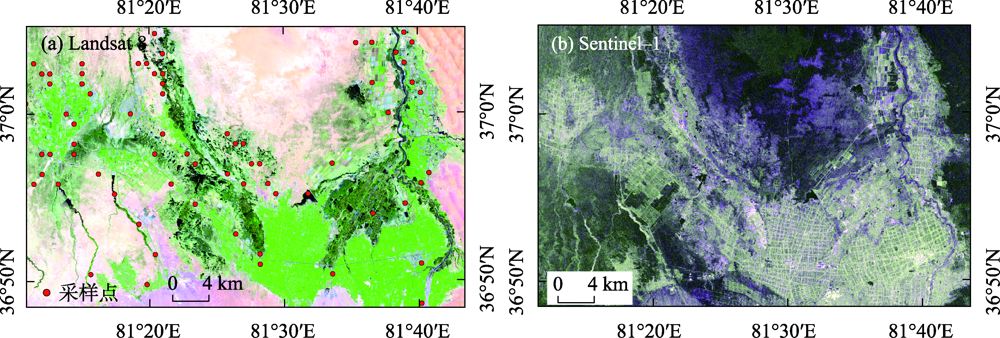
表1
遥感数据参数"
| 卫星传感器 | 获取日期 | 分辨率/m | 产品类型 | 极化方式/波段 |
|---|---|---|---|---|
| PALSAR-2 | 2015-04-23 | 10×10 | Level 1.1 | VV、VH |
| Sentinel-1A | 2018-04-23 | 10×10 | GRD | VV、VH |
| Sentinel-1A | 2021-04-18 | 10×10 | GRD | VV、VH |
| Landsat8 OLI | 2015-04-26 | 30×30 | Level1T | 1~7 |
| Landsat8 OLI | 2018-04-18 | 30×30 | Level1T | 1~7 |
| Landsat8 OLI | 2021-04-10 | 30×30 | Level1T | 1~7 |
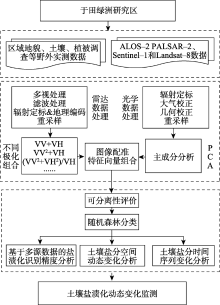
图2
技术路线图"

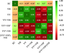
图3
Pearson相关性矩阵 注:EC为土壤电导率;*在0.05级别(双尾)相关性显著。"

表2
分类特征数据集组合"
| 序列 | 组合方式 | 简称 | 波段 | 备注 |
|---|---|---|---|---|
| Ⅰ | PCA光谱特征 | 方式一 | 3 | - |
| Ⅱ | 后向散射特征 | 方式二 | 4 | VV VV+VH VV2+VH (VV2+VH2)/VH |
| Ⅲ | PCA+后向散射特征 | 方式三 | 7 | - |
表3
典型地物的J-M距离"
| 地物 | 数据集 | 样本J-M测度 | |||
|---|---|---|---|---|---|
| 轻中度盐渍地 | 裸地 | 植被 | 水体 | ||
| 重度盐渍地 | 方式一 | 1.710 | 1.928 | 1.762 | 1.924 |
| 方式二 | 1.274 | 1.249 | 1.456 | 1.684 | |
| 方式三 | 1.893 | 1.899 | 1.973 | 2.000 | |
表4
分类精度验证"
| 组合方式 | 2015年 | 2018年 | 2021年 | |||||||
|---|---|---|---|---|---|---|---|---|---|---|
| 总体精度/% | Kappa系数 | 总体精度/% | Kappa系数 | 总体精度/% | Kappa系数 | |||||
| 方式一 | 79.55 | 0.75 | 80.32 | 0.77 | 81.21 | 0.79 | ||||
| 方式三 | 85.19 | 0.81 | 84.59 | 0.80 | 87.07 | 0.84 | ||||
图4
随机森林分类结果对比 注:图a和图c为PCA光谱特征分类结果;图b和图d为PCA+后向散射特征分类结果。"

图5
各年份图像分类结果"
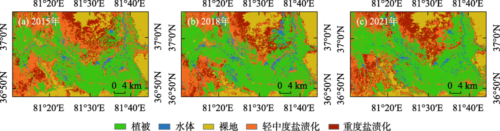
表5
2015—2021年地物分类面积变化"
| 分类类别 | 2015年 | 2018年 | 2021年 | |||||||
|---|---|---|---|---|---|---|---|---|---|---|
| 面积/hm2 | 比例/% | 面积/hm2 | 比例/% | 面积/hm2 | 比例/% | |||||
| 水体 | 4839.01 | 3.09 | 7652.32 | 4.88 | 5553.04 | 3.52 | ||||
| 植被 | 61061.10 | 38.94 | 68645.04 | 43.78 | 71506.76 | 45.31 | ||||
| 裸地 | 27970.34 | 17.84 | 25340.48 | 16.16 | 24533.92 | 15.54 | ||||
| 轻中度盐渍地 | 41518.64 | 26.48 | 36462.24 | 23.25 | 32359.16 | 20.51 | ||||
| 重度盐渍地 | 21411.11 | 13.65 | 18700.08 | 11.93 | 23847.28 | 15.12 | ||||
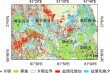
图6
2015—2021年盐渍地变化分布"
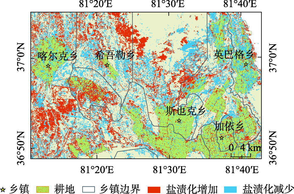

图7
2015—2021年地物类型转移图"

| [1] | 孙媛, 贾萍萍, 尚天浩, 等. 基于地表高光谱与OLI影像的土壤含盐量和pH值估测[J]. 干旱地区农业研究, 2021, 39(1): 164-174. |
| [Sun Yuan, Jia Pingping, Shang Tianhao, et al. Estimation of soil salinity and pH value based on surface hyperspectral and OLI images[J]. Agricultural Research in the Arid Areas, 2021, 39(1): 164-174.] | |
| [2] | 刘延锋, 靳孟贵, 金英春. 焉耆盆地土壤盐渍化状况的主成分分析[J]. 干旱地区农业研究, 2004, 22(1): 165-171. |
| [Liu Yanfeng, Jin Menggui, Jin Yingchun. Principal component analysis of soil salinization in Yanqi Basin[J]. Agricultural Research in the Arid Areas, 2004, 22(1): 165-171.] | |
| [3] | 田长彦, 周宏飞, 刘国庆. 21世纪新疆土壤盐渍化调控与农业持续发展研究建议[J]. 干旱区地理, 2000, 23(2): 177-181. |
| [Tian Changyan, Zhou Hongfei, Liu Guoqin. Research suggestions on soil salinization regulation and agricultural sustainable development in Xinjiang in the 21st century[J]. Arid Land Geography, 2000, 23(2): 177-181.] | |
| [4] | 魏云杰, 许模. 新疆土壤盐渍化成因及其防治对策研究[J]. 地球与环境, 2005, 33(S1): 593-597. |
| [Wei Yunjie, Xu Mu. Study on the causes and countermeasures of soil salinization in Xinjiang[J]. Earth and Environment, 2005, 33(S1): 593-597.] | |
| [5] | 张士功, 邱建军, 张华. 我国盐渍土资源及其综合治理[J]. 中国农业资源与区划, 2000, 21(1): 54-58. |
| [Zhang Shigong, Qiu Jianjun, Zhang Hua. Salinized soil resources and comprehensive management in China[J]. Chinese Journal of Agricultural Resources and Regional Planning, 2000, 21(1): 54-58.] | |
| [6] | 尼加提·卡斯木, 师庆东, 郭玉川, 等. 基于EM38和WorldView-2影像的土壤盐渍化建模研究[J]. 土壤, 2019, 51(3): 594-601. |
| [Nijat Kasim, Shi Qingdong, Guo Yuchuan, et al. Mapping and modelling of soil salinity using WorldView-2 data and EM38 in arid region of Keriya river, China[J]. Soils, 2019, 51(3): 594-601.] | |
| [7] | 陈香月, 丁建丽, 葛翔宇, 等. 基于机器学习的绿洲土壤盐渍化尺度效应研究[J]. 农业机械学报, 2021, 52(9): 312-320. |
| [Chen Xiangyue, Ding Jianli, Ge Xiangyu, et al. Scale effect on soil salinization simulation in arid oasis based on machine learning methods[J]. Transactions of the Chinese Society for Agricultural Machinery, 2021, 52(9): 312-320.] | |
| [8] | 黄权中, 徐旭, 吕玲娇, 等. 基于遥感反演河套灌区土壤盐分分布及对作物生长的影响[J]. 农业工程学报, 2018, 34(1): 102-109. |
| [Huang Quanzhong, Lv Lingjiao, et al. Soil salinity distribution based on remote sensing and its effect on crop growth in Hetao irrigation district[J]. Transactions of the Chinese Society of Agricultural Engineering, 2018, 34(1): 102-109.] | |
| [9] |
翁永玲, 宫鹏. 土壤盐渍化遥感应用研究进展[J]. 地理科学, 2006, 26(3): 369-375.
doi: 10.13249/j.cnki.sgs.2006.03.369 |
|
[Weng Yongling, Gong Peng. A review on remote sensing technique for salt-affected soils[J]. Scientia Geographica Sinica, 2006, 26(3): 369-375.]
doi: 10.13249/j.cnki.sgs.2006.03.369 |
|
| [10] | 马腾, 王耀强, 李瑞平, 等. 基于微波遥感极化目标分解的土地覆盖/土地利用分类[J]. 农业工程学报, 2015, 31(2): 259-265. |
| [Ma Teng, Wang Yaoqiang, Li Ruiping, et al. Land Cover/Land Use classification based on polarimetric target decomposition of microwave remote sensing[J]. Transactions of the Chinese Society of Agricultural Engineering, 2015, 31(2): 259-265.] | |
| [11] | 赵孟银. 遥感影像去云方法研究[D]. 天津: 天津科技大学, 2016. |
| [Zhao Mengyin. Study of Cloud Removal Method on Remote Sensing Image[D]. Tianjin:Tianjin University of Science and Technology, 2016.] | |
| [12] | 雷博恩, 王世航. 微波遥感应用现状综述[J]. 科技广场, 2016, 29(6): 171-174. |
| [Lei Bo’en, Wang Shihang. Review on status quo of microwave remote sensing application[J]. Science Mosaic, 2016, 29(6): 171-174.] | |
| [13] | 刘全明, 成秋明, 王学, 等. 河套灌区土壤盐渍化微波雷达反演[J]. 农业工程学报, 2016, 32(16): 109-114. |
| [Liu Quanming, Cheng Qiuming, Wang Xue, et al. Soil salinity inversion in Hetao Irrigation district using microwave radar[J]. Transactions of the Chinese Society of Agricultural Engineering, 2016, 32(16): 109-114.] | |
| [14] |
Shao Y, Hu Q R, Guo H D, et al. Effect of dielectric properties of moist salinized soils on backscattering coefficients extracted from RADARSAT image[J]. IEEE Transactions on Geoscience and Remote Sensing, 2003, 41(8): 1879-1888.
doi: 10.1109/TGRS.2003.813499 |
| [15] | 李彪, 王耀强. 土壤盐渍化雷达反演模拟研究[J]. 干旱区资源与环境, 2015, 29(8): 180-184. |
| [Li Biao, Wang Yaoqiang. Radar inversion and simulation of salty soil salinization[J]. Journal of Arid Land Resources and Environment, 2015, 29(8): 180-184.] | |
| [16] |
Wu W, Claudio Z, Muhaimeed A S, et al. Soil salinity prediction and mapping by machine learning regression in Central Mesopotamia, Iraq[J]. Land Degradation and Development, 2018, 29(11): 4005-4014.
doi: 10.1002/ldr.3148 |
| [17] |
Wang N, Xue J, Peng J, et al. Integrating remote sensing and landscape characteristics to estimate soil salinity using machine learning methods: A case study from southern Xinjiang, China[J]. Remote Sensing, 2020, 12(24): 4118.
doi: 10.3390/rs12244118 |
| [18] |
Ma G L, Ding J L, Han L J, et al. Digital mapping of soil salinization based on Sentinel-1 and Sentinel-2 data combined with machine learning algorithms[J]. Regional Sustainability, 2021, 2(2): 177-188.
doi: 10.1016/j.regsus.2021.06.001 |
| [19] | 依力亚斯江·努尔麦麦提, 师庆东, 阿不都拉·阿不力孜, 等. 灰色评估模型定量评价于田绿洲土壤盐渍化风险[J]. 农业工程学报, 2019, 35(8): 176-184. |
| [Ilyas Nurmemet, Shi Qingdong, Abdulla Abliz, et al. Quantitative evaluation of soil salinization risk in Keriya Oasis based on grey evaluation model[J]. Transactions of the Chinese Society of Agricultural Engineering, 2019, 35(8): 176-184.] | |
| [20] | 韩丽. 克里雅河流域于田绿洲土壤质量研究[D]. 乌鲁木齐: 新疆大学, 2014. |
| [Han Li. Research on Soil Quality in Yutian Oasis of the Keriya Valley[D]. Urumqi: Xinjiang University, 2014.] | |
| [21] | 顾思博, 周金龙, 曾妍妍, 等. 绿洲农田土壤微量营养元素的空间变异性研究——以新疆于田县为例[J]. 干旱区资源与环境, 2020, 34(3): 118-123. |
| [Gu Sibo, Zhou Jinlong, Zeng Yanyan, et al. Spatial variability of trace elements in oasis farmland soil: A case study in Yutian County, Xinjiang[J]. Journal of Arid Land Resources and Environment, 2020, 34(3): 118-123.] | |
| [22] |
再屯古丽·亚库普, 买买提·沙吾提, 阿卜杜萨拉木·阿布都加帕尔, 等. 基于PALSAR雷达数据的于田绿洲土壤盐渍化反演[J]. 资源科学, 2018, 40(10): 2110-2117.
doi: 10.18402/resci.2018.10.18 |
|
[Zaytungul Yakup, Mamat Sawut, Abdusalam Abdujappar, et al. Soil salinity inversion in Yutian Oasis based on PALSAR radar data[J]. Resources Science, 2018, 40(10): 2110-2117.]
doi: 10.18402/resci.2018.10.18 |
|
| [23] | 周林虎, 王昊宇, 张秉来, 等. 硫酸盐渍土表观电导率与水分、盐分及粒径关系研究[J]. 干旱区研究, 2021, 38(4): 1020-1030. |
| [Zhou Linhu, Wang Haoyu, Zhang Binglai, et al. The relationship between EC_a of sulfate saline soil and moisture content, salt content, and particle size[J]. Arid Zone Research, 2021, 38(4): 1020-1030.] | |
| [24] | 郭连坤. 基于多核Boosting多特征组合高光谱分类技术研究[D]. 西安: 西安科技大学, 2015. |
| [Guo Liankun. Classification of Hyperspectral Data based on Multi-feature Combination by Multiple Kernel Boosting[D]. Xi’an: Xi’an University of Science and Technology, 2015.] | |
| [25] | 刘子维. 基于多特征的高分辨率遥感影像分类研究[D]. 长春: 吉林大学, 2021. |
| [Liu Ziwei. Research on High-resolution Remote Sensing Image Classification based on Multi-feature[D]. Changchun: Jilin University, 2021.] | |
| [26] | 刘焕军, 杨昊轩, 徐梦园, 等. 基于裸土期多时相遥感影像特征及最大似然法的土壤分类[J]. 农业工程学报, 2018, 34(14): 132-139, 304. |
| [Liu Huanjun, Yang Haoxuan, Xu Mengyuan, et al. Soil classification based on maximum likelihood method and features of multi-temporal remote sensing images in bare soil period[J]. Transactions of the Chinese Society of Agricultural Engineering, 2018, 34(14): 132-139, 304.] | |
| [27] | 邢立亭, 李净, 焦文慧. 基于MODIS和随机森林的兰州市日最高气温和最低气温估算[J]. 干旱区研究, 2020, 37(3): 689-695. |
| [Xing Liting, Li Jing, Jiao Wenhui. Estimation of daily maximum and minimum temperature of Lanzhou City based on MODIS and random forest[J]. Arid Zone Research, 2020, 37(3): 689-695.] | |
| [28] | 陈媛媛, 郑加柱, 魏浩翰, 等. 基于不同特征的随机森林极化SAR图像分类[J]. 计算机系统应用, 2019, 28(8): 183-189. |
| [Chen Yuanyuan, Zheng Jiazhu, Wei Haohan, et al. Tidal flat classification based on random forest model using different features of polarimetric SAR[J]. Computer Systems & Applications, 2019, 28(8): 183-189.] | |
| [29] | 徐乔, 张霄, 余绍淮, 等. 综合多特征的极化SAR图像随机森林分类算法[J]. 遥感学报, 2019, 23(4): 685-694. |
| [Xu Qiao, Zhang Xiao, Yu Shaohuai, et al. Multi-feature-based classification method using random forest and superpixels for polarimetric SAR images[J]. Journal of Remote Sensing, 2019, 23(4): 685-694.] | |
| [30] |
Belgiu M, Dragut L. Random forest in remote sensing: A review of applications and future directions[J]. ISPRS Journal of Photogrammetry and Remote Sensing, 2016, 114: 24-31.
doi: 10.1016/j.isprsjprs.2016.01.011 |
| [31] |
乔木, 周生斌, 卢磊, 等. 新疆渭干河流域土壤盐渍化时空变化及成因分析[J]. 地理科学进展, 2012, 31(7): 904-910.
doi: 10.11820/dlkxjz.2012.07.009 |
|
[Qiao Mu, Zhou Shengbin, Lu Lei, et al. Causes and spatial-temporal changes of soil salinization in Weigan River Basin, Xinjiang[J]. Progress in Geography, 2012, 31(7): 904-910.]
doi: 10.11820/dlkxjz.2012.07.009 |
|
| [32] | 尼格拉·吐尔逊, 依力亚斯江·努尔麦麦提, 王远弘, 等. 基于H/A/α分解全极化合成孔径雷达数据的干旱区土壤盐渍化分类[J]. 江苏农业科学, 2019, 47(22): 273-279. |
| [Nigela Tuerxun, Ilyas Nurmemet, Wang Yuanhong, et al. Classification of soil salinization in arid areas based on H/A/α polarization decomposition method of POLSAR data[J]. Jiangsu Agricultural Sciences, 2019, 47(22): 273-279.] | |
| [33] | 胡庆荣. 含水含盐土壤介电特性实验研究及对雷达图像的响应分析[D]. 北京: 中国科学院研究生院, 2003. |
| [Hu Qingrong. Studies on Microwave Dielectric Behavior of Moist Salt Soil and Its Effect on Backscattering Cofficients Extracted from Radar Image[D]. Beijing: Graduate University of Chinese Academy of Sciences, 2003.] | |
| [34] | 贾海峰, 刘雪华. 环境遥感原理与应用[M]. 北京: 清华大学出版社, 2006. |
| [Jia Haifeng, Liu Xuehua. The Principle of Environmental Remote Sensing and Its Applications[M]. Beijing: Tsinghua University Press, 2006.] | |
| [35] | Metternicht G I. Analysing the relationship between ground-based reflectance and environmental indicators of salinity processes in the Cochabamba valleys (Bolivia)[J]. International Journal of Ecology & Environmental Sciences, 1998, 24(4): 359-370. |
| [36] |
雷志斌, 孟庆岩, 田淑芳, 等. 基于GF-3和Landsat8遥感数据的土壤水分反演研究[J]. 地球信息科学学报, 2019, 21(12): 1965-1976.
doi: 10.12082/dqxxkx.2019.190115 |
|
[Lei Zhibin, Meng Qingyan, Tian Shufang, et al. Soil moisture retrieval study based on GF-3 and Landsat8 remote sensing data[J]. Journal of Geo-information Science, 2019, 21(12): 1965-1976.]
doi: 10.12082/dqxxkx.2019.190115 |
|
| [37] | 董显聪. 植被覆盖下盐渍土含盐量的遥感反演研究[D]. 北京: 中国科学院大学, 2021. |
| [Dong Xiancong. Retrieval of Saline Soil Salinity under Vegetation Cover based on Remote Sensing[D]. Beijing: University of Chinese Academy of Sciences, 2021.] | |
| [38] | 刘国华. 于田绿洲土壤盐分特征及其成盐驱动因子分析[D]. 乌鲁木齐: 新疆大学, 2009. |
| [Liu Guohua. Study on Soil Salinity Characteristics and Its Salt-driven Actuation Factors in Yutian Oasis[D]. Urumqi: Xinjiang University, 2009.] | |
| [39] | 周利颖, 李瑞平, 苗庆丰, 等. 内蒙古河套灌区紧邻排干沟土壤盐渍化与肥力特征分析[J]. 干旱区研究, 2021, 38(1): 114-122. |
| [Zhou Liying, Li Ruiping, Miao Qingfeng, et al. Characteristics of salinization and fertility of saline-alkali soil adjacent to drainage ditch in Hetao irrigation area of Inner Mongolia[J]. Arid Zone Research, 2021, 38(1): 114-122.] | |
| [40] | 李艳菊. 渭-库绿洲土壤盐分时空动态演变及驱动因子研究[D]. 乌鲁木齐: 新疆大学, 2019. |
| [Li Yanju. Temporal and Spatial Dynamic Dvolution and Driving Factors of Soil Salinity in the Ogan Kucha River Oasis[D]. Urumqi: Xinjiang University, 2019.] | |
| [41] |
杨劲松, 姚荣江. 黄河三角洲地区土壤水盐空间变异特征研究[J]. 地理科学, 2007, 27(3): 348-353.
doi: 10.13249/j.cnki.sgs.2007.03.348 |
|
[Yang Jinsong, Yao Rongjiang. Spatial variability of soil water and salt characteristics in the Yellow River Delta[J]. Scientia Geographica Sinica, 2007, 27(3): 348-353.]
doi: 10.13249/j.cnki.sgs.2007.03.348 |
|
| [42] | 苏春利, 纪倩楠, 陶彦臻, 等. 河套灌区西部土壤盐渍化分异特征及其主控因素[J]. 干旱区研究, 2022, 39(3): 916-923. |
| [Su Chunli, Ji Qiannan, Tao Yanzhen, et al. Differentiation characteristics and main influencing factors of soil salinization in the West of Hetao[J]. Arid Zone Research, 2022, 39(3): 916-923.] | |
| [43] | 王海江, 石建初, 张花玲, 等. 不同改良措施下新疆重度盐渍土壤盐分变化与脱盐效果[J]. 农业工程学报, 2014, 30(22): 102-111. |
| [Wang Haijiang, Shi Jianchu, Zhang Hualing, et al. Soil salinity dynamic change and desalting effect under different improvement measures in severe salinity soil in Xinjiang[J]. Transactions of the Chinese Society of Agricultural Engineering, 2014, 30(22): 102-111.] | |
| [44] |
Seydehmet J, Lv G H, Nurmrmet I, et al. Model prediction of secondary soil salinization in the Keriya Oasis, Northwest China[J]. Sustainability, 2018, 10(3): 656.
doi: 10.3390/su10030656 |
| [1] | 刘一丹, 姚晓军, 李宗省, 胡家瑜. 气候变化和土地利用覆盖变化对河西地区植被净初级生产力的影响[J]. 干旱区研究, 2024, 41(1): 169-180. |
| [2] | 文妙霞, 何学高, 刘欢, 张婧, 罗晨, 贾丰铭, 王义贵, 胡云云. 基于地理探测器的宁夏草地植被覆被时空分异及驱动因子[J]. 干旱区研究, 2023, 40(8): 1322-1332. |
| [3] | 李虹, 李忠勤, 陈普晨, 彭加加. 近20 a新疆阿尔泰山积雪时空变化及其影响因素[J]. 干旱区研究, 2023, 40(7): 1040-1051. |
| [4] | 王士维, 孙栋元, 周敏, 王亦可, 王祥镔, 季宗虎, 张文睿, 武兰珍. 1951—2020年疏勒河流域气温时空变化特征[J]. 干旱区研究, 2023, 40(7): 1065-1074. |
| [5] | 赵卓怡, 郝兴明. 基于Priestley-Taylor方法的中亚干旱区实际蒸散特征及归因[J]. 干旱区研究, 2023, 40(7): 1085-1093. |
| [6] | 薛一波, 张小啸, 雷加强, 李生宇, 王永东, 尤源. 北非埃及地区风蚀沙尘时空变化研究[J]. 干旱区研究, 2023, 40(6): 896-904. |
| [7] | 任丽雯, 王兴涛, 刘明春, 王大为. 石羊河流域植被净初级生产力时空变化及驱动因素[J]. 干旱区研究, 2023, 40(5): 818-828. |
| [8] | 李鑫磊, 李瑞平, 王秀青, 王思楠, 王成坤. 基于地理探测器的河套灌区林草植被覆盖度时空变化与驱动力分析[J]. 干旱区研究, 2023, 40(4): 623-635. |
| [9] | 康利刚, 曹生奎, 曹广超, 杨羽帆, 严莉, 王有财. 青海湖沙柳河流域蒸散发时空变化特征[J]. 干旱区研究, 2023, 40(3): 358-372. |
| [10] | 许丽婷,刘海红,黄丽洁,王钰帆. 2000—2020年汾河流域生态环境与水源涵养时空变化[J]. 干旱区研究, 2023, 40(2): 313-325. |
| [11] | 侯文兵, 李开明, 黄卓. 近20 a河西地区绿洲效应时空变化特征及归因分析[J]. 干旱区研究, 2023, 40(12): 2031-2042. |
| [12] | 姚佳,陈启慧,李琼芳,崔罡,张良憬. 伊犁河—巴尔喀什湖流域实际蒸散发时空变化特征及其环境影响因子[J]. 干旱区研究, 2022, 39(5): 1564-1575. |
| [13] | 冶晓娟,王永辉,潘红忠,白钰,董得福,姚华明. 青海省植被NEP时空变化及驱动因素分析[J]. 干旱区研究, 2022, 39(5): 1673-1683. |
| [14] | 苏春利,纪倩楠,陶彦臻,谢先军,潘洪捷. 河套灌区西部土壤盐渍化分异特征及其主控因素[J]. 干旱区研究, 2022, 39(3): 916-923. |
| [15] | 白建铎,彭杰,史舟,王玉珍,柳维扬,李洪义. 基于多源数据的干旱区盐渍化农田精准管理分区研究[J]. 干旱区研究, 2022, 39(2): 646-655. |
|
||