干旱区研究 ›› 2024, Vol. 41 ›› Issue (6): 917-927.doi: 10.13866/j.azr.2024.06.02
李小等1,2( ), 常亮1,3, 段瑞1, 王倩1, 张群慧1, 杨炳超1
收稿日期:2023-10-10
修回日期:2024-01-26
出版日期:2024-06-15
发布日期:2024-07-03
作者简介:李小等(1981-),男,硕士,高级工程师,主要从事水文地球化学等方面研究. E-mail: 15002947390@163.com
基金资助:
LI Xiaodeng1,2(), CHANG Liang1,3, DUAN Rui1, WANG Qian1, ZHANG Qunhui1, YANG Bingchao1
Received:2023-10-10
Revised:2024-01-26
Online:2024-06-15
Published:2024-07-03
摘要:
为研究和田河流域水化学与地下水补给特征,采用SPSS数理统计分析、Piper三线图、Gibbs图解以及氢氧和14C同位素示踪等方法对不同地貌单元中的水体(井水、坑塘水和河水)进行了水化学组成特征、补给来源和转化关系分析。结果表明:(1) 各水体主要起源于南部海拔2000 m以上的中高山区冰雪融水和大气降水。从山区到沙漠区,地下水水化学类型具有较明显的分带特征。不同水体pH值均呈弱碱性,离子之间组分和TDS值差异较大,整体呈坑塘水>井水>河水的规律。少数地下水样点中NO3-含量显著异常。(2) 砾质平原区地下水大量接受地表河水的垂向脱节型补给。地下水溶解性总固体(TDS)值小,更新速度快,以水岩溶滤控制作用为主,水化学类型多呈SO4·Cl-Ca·Mg型。(3) 细土平原区地下水TDS值变幅大,多为Cl·SO4-Na型。其中,河间地块内,靠近上游地下水接受地表水及邻区侧向径流补给,14C年龄小;中下游地区地下水氢氧同位素“氧漂移”现象普遍。分水岭处地下水14C年龄大,近河岸处年龄小,地下水与河水联系密切。河间地块两侧地下水分别沿东北、西北方向径流,最终排泄于外围沙漠区。研究结果可为和田河流域水资源合理开发利用和生态环境保护提供科学理论依据。
李小等, 常亮, 段瑞, 王倩, 张群慧, 杨炳超. 和田河流域水化学特征与地下水补给来源分析[J]. 干旱区研究, 2024, 41(6): 917-927.
LI Xiaodeng, CHANG Liang, DUAN Rui, WANG Qian, ZHANG Qunhui, YANG Bingchao. Analysis of the hydrochemistry characteristics and groundwater recharge sources in the Hotan River Basin, China[J]. Arid Zone Research, 2024, 41(6): 917-927.
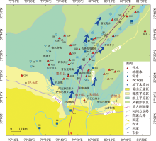
图1
和田河流域不同水体水样点分布示意图"

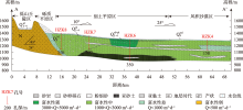
图2
和田河流域南北向水文地质剖面示意图"

表1
不同水体水化学参数统计"
| 类型 | 指标 | K+/(mg·L-1) | Na+/(mg·L-1) | Ca2+/(mg·L-1) | Mg2+/(mg·L-1) | Cl-/(mg·L-1) | SO42-/(mg·L-1) | HCO3-/(mg·L-1) | NO3-/(mg·L-1) | TDS/(mg·L-1) | pH |
|---|---|---|---|---|---|---|---|---|---|---|---|
| 地下水 | 极差 | 39.20 | 689.39 | 108.77 | 131.21 | 1101.43 | 653.69 | 572.59 | 18.49 | 2681.04 | 0.57 |
| 最小值 | 5.66 | 52.65 | 39.33 | 7.55 | 73.74 | 105.53 | 134.30 | 0.25 | 381.16 | 7.59 | |
| 最大值 | 44.86 | 742.04 | 148.10 | 138.76 | 1175.17 | 759.22 | 706.89 | 18.74 | 3062.20 | 8.16 | |
| 平均值 | 19.73 | 283.87 | 82.04 | 64.21 | 403.08 | 265.50 | 351.25 | 4.57 | 1299.64 | 7.90 | |
| 标准差 | 7.74 | 165.22 | 33.66 | 32.03 | 243.67 | 134.20 | 139.56 | 4.11 | 587.82 | 0.17 | |
| 变异系数 | 0.39 | 0.58 | 0.41 | 0.50 | 0.60 | 0.51 | 0.40 | 0.90 | 0.45 | 0.02 | |
| 坑塘水 | 极差 | 61.81 | 1166.35 | 205.89 | 220.80 | 1522.22 | 1318.54 | 383.36 | 16.41 | 3851.77 | 2.13 |
| 最小值 | 14.82 | 214.35 | 19.67 | 49.42 | 264.46 | 236.93 | 163.60 | 3.02 | 1036.91 | 7.70 | |
| 最大值 | 76.63 | 1380.70 | 225.56 | 270.22 | 1786.68 | 1555.47 | 546.96 | 19.43 | 4888.68 | 9.83 | |
| 平均值 | 53.21 | 844.05 | 83.38 | 154.19 | 917.45 | 749.27 | 361.08 | 6.39 | 3028.06 | 8.53 | |
| 标准差 | 20.72 | 414.77 | 77.33 | 69.00 | 523.16 | 479.44 | 152.65 | 5.53 | 1319.11 | 0.70 | |
| 变异系数 | 0.39 | 0.49 | 0.93 | 0.45 | 0.57 | 0.64 | 0.42 | 0.87 | 0.44 | 0.08 | |
| 河 水 | 极差 | 5.05 | 80.33 | 28.50 | 19.48 | 123.37 | 73.98 | 80.58 | 2.87 | 366.78 | 0.46 |
| 最小值 | 5.30 | 46.48 | 50.97 | 10.22 | 63.10 | 79.55 | 148.95 | 2.10 | 338.26 | 7.77 | |
| 最大值 | 10.35 | 126.81 | 79.47 | 29.70 | 186.47 | 153.53 | 229.53 | 4.97 | 705.04 | 8.23 | |
| 平均值 | 7.03 | 79.28 | 62.73 | 18.08 | 111.31 | 120.12 | 176.51 | 4.02 | 491.49 | 7.98 | |
| 标准差 | 1.75 | 28.00 | 10.49 | 6.47 | 41.55 | 25.64 | 31.75 | 0.99 | 123.60 | 0.16 | |
| 变异系数 | 0.25 | 0.35 | 0.17 | 0.36 | 0.37 | 0.21 | 0.18 | 0.25 | 0.25 | 0.02 |

图3
不同水体Piper三线图"

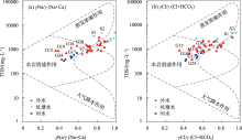
图4
流域不同水体Gibbs图"

表2
不同水体δD、δ18O和d-excess参数统计"
| 类型 | 指标 /‰ | 极差 /‰ | 最小值 /‰ | 最大值 /‰ | 平均值 /‰ | 标准 差 | 变异 系数 |
|---|---|---|---|---|---|---|---|
| 地下水 | δD | 27.50 | -69.12 | -41.62 | -55.02 | 6.37 | -0.12 |
| δ18O | 3.86 | -11.31 | -7.45 | -8.91 | 1.00 | -0.11 | |
| d-excess | 13.17 | 11.88 | 25.05 | 16.25 | 3.07 | 0.19 | |
| 坑塘水 | δD | 44.11 | -41.40 | 2.72 | -26.63 | 15.09 | -0.57 |
| δ18O | 10.13 | -6.46 | 3.67 | -2.88 | 3.71 | -1.29 | |
| d-excess | 37.26 | -26.95 | 10.30 | -3.57 | 15.01 | -4.20 | |
| 河水 | δD | 8.71 | -51.77 | -43.07 | -47.15 | 2.95 | -0.06 |
| δ18O | 1.97 | -9.32 | -7.34 | -8.40 | 0.74 | -0.09 | |
| d-excess | 13.32 | 15.68 | 29.00 | 20.05 | 5.68 | 0.28 |

图5
不同水体δD-δ18O关系曲线"
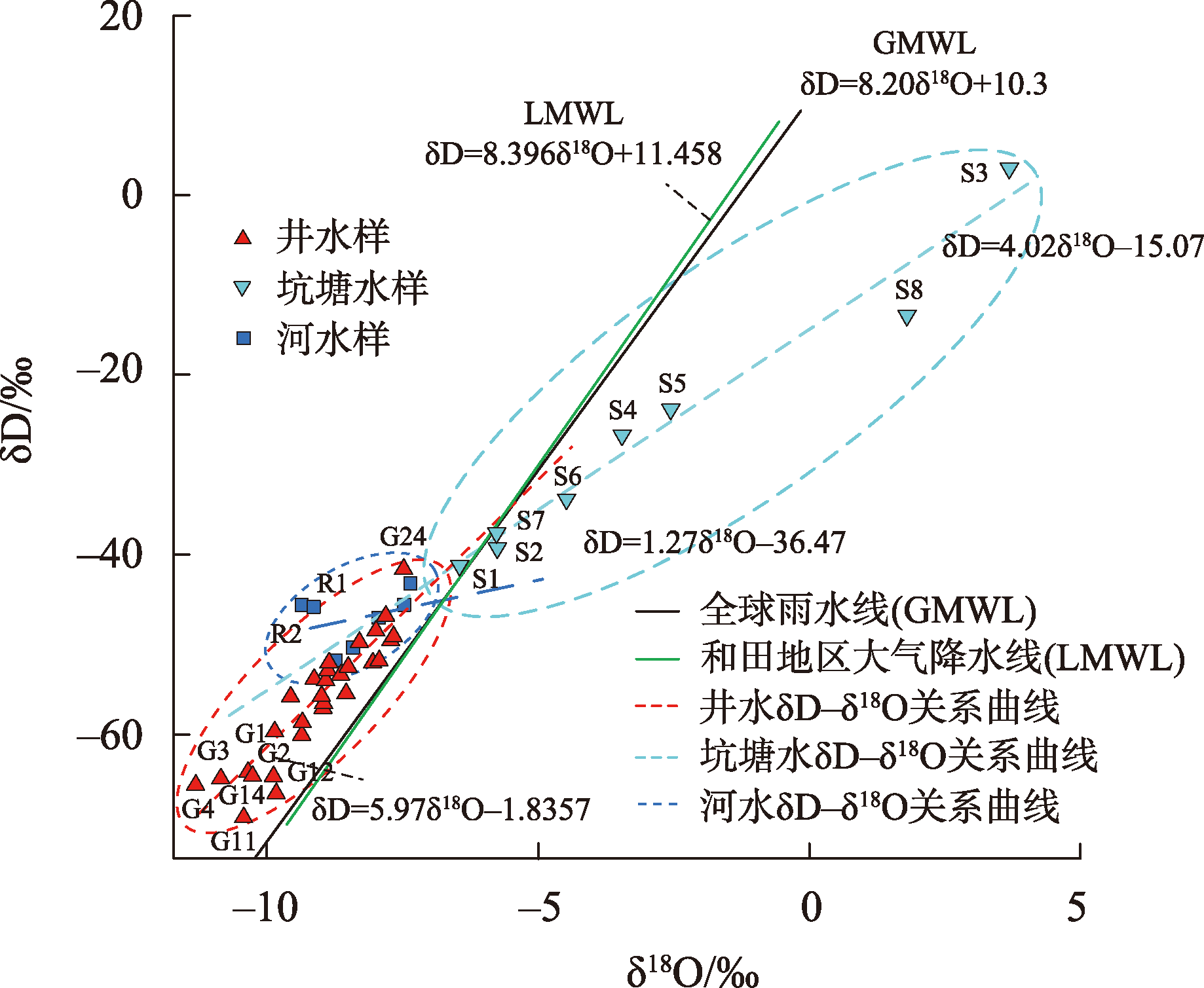
表3
同位素部分样点特征值及参数统计"
| 样品编号 | 井深/m | 水位埋深/m | 取样高程/m | 补给高程/m | δD/‰ | δO/‰ | d-excess/‰ | 14C年龄/aB.P. | ||
|---|---|---|---|---|---|---|---|---|---|---|
| G6 | 130 | 4.03 | 1316 | 1932 | -48.92 | -7.68 | 12.55 | 330 | ||
| G8 | 120 | 4.21 | 1299 | 2379 | -53.66 | -8.32 | 12.90 | 2930 | ||
| G10 | 80 | 4.27 | 1275 | 2067 | -53.88 | -8.38 | 13.16 | 320 | ||
| G12 | 100 | 3.75 | 1260 | 2127 | -55.33 | -8.57 | 13.21 | 9780 | ||
| G14 | 75 | 3.45 | 1268 | 2636 | -66.02 | -9.82 | 12.54 | 7290 | ||
| G25 | 85 | 3.13 | 1315 | 1929 | -53.00 | -8.37 | 13.96 | 810 |
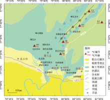
图6
14C取样位置分布及年龄"

| [1] | 曾小仙, 曾妍妍, 周金龙, 等. 石河子市浅层地下水化学特征及其成因分析[J]. 干旱区研究, 2021, 38(1): 68-75. |
| [Zeng Xiaoxian, Zeng Yanyan, Zhou Jinlong, et al. Hydrochemical characteristics and cause analysis of the shallow groundwater in Shihezi City[J]. Arid Zone Research, 2021, 38(1): 68-75. ] | |
| [2] | 李杰彪, 梁修雨, 周志超, 等. 某地下核设施场址地下水化学特征及其对水循环的指示意义[J]. 地球科学, 2024, 49(3): 965-977. |
| [Li Jiebiao, Liang Xiuyu, Zhou Zhichao, et al. Hydrochemical characteristics and its significance to groundwater flow system at an underground nuclear facility site[J]. Earth Science, 2024, 49(3): 965-977. ] | |
| [3] | 孙琪, 徐长春, 任正良, 等. 塔里木河流域产水量时空分布及驱动因素分析[J]. 灌溉排水学报, 2021, 40(8): 114-122. |
| [Sun Qi, Xu Changchun, Ren Zhengliang, et al. Spatiotemporal variation in water yield and their underlying mechanisms in Tarim River Basin[J]. Journal of Irrigation and Drainage, 2021, 40(8): 114-122. ] | |
| [4] | 陈宗宇, 万力, 聂振龙, 等. 利用稳定同位素识别黑河流域地下水的补给来源[J]. 水文地质工程地质, 2006, 33(6): 9-14. |
| [Chen Zongyu, Wan Li, Nie Zhenlong, et al. Identification of groundwater recharge in the Heihe Basin using environmental isotopes[J]. Hydrogeology and Engineering Geology, 2006, 33(6): 9-14. ] | |
| [5] | 马金珠, 黄天明, 丁贞玉, 等. 同位素指示的巴丹吉林沙漠南缘地下水补给来源[J]. 地球科学进展, 2007, 22(9): 923-930. |
| [Ma Jinzhu, Huang Tianming, Ding Zhenyu, et al. Environmental isotopesas the indicators of the groundwater recharge in the South Badain Jaran Desert[J]. Advances in Earth Science, 2007, 22(9): 923-930. ] | |
| [6] | O’Driscoll M A, Dewalle D R, Mcguire K J, et al. Seasonal 18O variations and groundwater recharge for three landscape types in central Pennsylvania, USA[J]. Journal of Hydrology, 2005, 303: 108-124. |
| [7] | 徐学选, 张北赢, 田均良. 黄土丘陵区降水-土壤水-地下水转化实验研究[J]. 水科学进展, 2010, 21(1): 16-21. |
| [Xu Xuexuan, Zhang Beiying, Tian Junliang. Experimental study on the precipitation-soil water-groundwater transformation in loess hilly region[J]. Advances in Water Science, 2010, 21(1): 16-21. ] | |
| [8] | 孙晨云, 郑和祥, 李瑞平, 等. 鄂尔多斯沿黄灌区大气降水稳定同位素特征与水汽来源分析[J]. 灌溉排水学报, 2022, 41(4) : 93-100. |
| [Sun Chenyun, Zheng Hexiang, Li Ruiping, et al. Stable Isotopes in precipitation in irrigation areas in the proximity of Yellow River in Ordos and the origin of its water vapor[J]. Journal of Irrigation and Drainage, 2022, 41(4): 93-100. ] | |
| [9] | 喻龙, 何峻岭, 艾书涛, 等. 新疆铁门关市域地下水氢氧稳定同位素特征分析[J]. 干旱区资源与环境, 2023, 37(1): 58-64. |
| [Yu Long, He Junling, Ai Shutao, et al. Characteristics of hydrogen and oxygen stable isotopes in groundwater of Tiemenguan City, Xinjiang[J]. Journal of Arid Land Resources and Environment, 2023, 37(1): 58-64. ] | |
| [10] | Rodriguez N B, Pfister L, Zehe E, et al. A comparison of catchment travel times and storage deduced from deuterium and tritium tracers using StorAge Selection functions[J]. Hydrology and Earth System Sciences, 2021, 25(1): 401-428. |
| [11] | Michael P S, Heye R B, Andreas L, et al. Time variability and uncertainty in the fraction of young water in a small headwater catchment[J]. Hydrology and Earth System Sciences, 2019, 23(10): 4333-4347. |
| [12] | 贾丹阳. 罗布泊地区红柳沙包记录的水分来源信息研究[D]. 石家庄: 河北师范大学, 2021: 33-47. |
| [Jia Danyang. Research on Water Source Information Recorded by Tamarix Cones in Lop Nur Region[D]. Shijiazhuang: Hebei Normal University, 2021: 33-47. ] | |
| [13] | 刘树宝, 陈亚宁, 陈亚鹏, 等. 基于稳定同位素技术的黑河下游不同林龄胡杨的吸水深度研究[J]. 生态学报, 2016, 36(3): 729-739. |
| [Liu Shubao, Chen Yaning, Chen Yapeng, et al. Study on the depth of water uptake by Populus euphratica trees of different ages in the lower reaches of the Heihe River, based on the stable isotope techniques[J]. Acta Ecologica Sinica, 2016, 36(3): 729-739. ] | |
| [14] | 吴华武, 李小雁, 蒋志云, 等. 基于δD 和δ18O的青海湖流域芨芨草水分利用来源变化研究[J]. 生态学报, 2015, 35(24): 8174-8183. |
| [Wu Huawu, Li Xiaoyan, Jiang Zhiyun, et al. Variations in water use for achnatherum splendens in Lake Qinghai watershed, based on δD and δ18O[J]. Acta Ecologica Sinica, 2015, 35(24): 8174-8183. ] | |
| [15] | 刘澄静, 角媛梅, 刘歆, 等. 基于氢氧稳定同位素的哈尼水稻梯田湿地水源补给分析[J]. 生态学杂志, 2018, 37(10): 3092-3099. |
| [Liu Chengjing, Jiao Yuanmei, Liu Xin, et al. Analysis on water supply of Hani rice terrace wetland based on stable hydrogen and oxygen isotopes[J]. Chinese Journal of Ecology, 2018, 37(10): 3092-3099. ] | |
| [16] | 刘鑫, 向伟, 司炳成. 汾河流域浅层地下水水化学和氢氧稳定同位素特征及其指示意义[J]. 环境科学, 2021, 42(4): 1739-1749. |
| [Liu Xin, Xiang Wei, Si Bingcheng. Hydrochemical and isotopic characteristics in the shallow groundwater of the Fenhe River basin and indicative significance[J]. Environmental Science, 2021, 42(4): 1739-1749. ] | |
| [17] | 王雨山, 尹德超, 祁晓凡, 等. 白洋淀不同水体氢氧同位素特征及其指示意义[J]. 环境科学, 2022, 43(4): 1920-1929. |
| [Wang Yushan, Yin Dechao, Qi Xiaofan, et al. Hydrogen and oxygen isotopic characteristics of different water and indicative significance in baiyangdian lake[J]. Environmental Science, 2022, 43(4): 1920-1929. ] | |
| [18] | Cotte Gabriel, Vennemann Torsten W. Mixing of Rhône River water in Lake Geneva: Seasonal tracing using stable isotope composition ofwater[J]. Journal of Great Lakes Research, 2020, 46(4): 839-849. |
| [19] |
Zhao Yunyun, Zheng Binghui, Wang Lijing, et al. Characterization of mixing processes in the confluence zone between the Three Gorges Reservoir mainstream and the Daning River using stable isotope analysis[J]. Environmental Science and Technology, 2016, 50(18): 9907-9914.
doi: 10.1021/acs.est.5b01132 pmid: 26320361 |
| [20] | Jiang Dejuan, Li Zhi, Luo Yongming, et al. River damming and drought affect water cycle dynamics in an ephemeral river based on stable isotopes: The Dagu River of North China[J]. Science of the Total Environment, 2021, 758: 143682. |
| [21] | 李丹, 张明珠, 庞园, 等. 广州市沿海平原地下水循环及转化规律初探[J]. 人民珠江, 2019, 40(9): 76-84. |
| [Li Dan, Zhang Mingzhu, Pang Yuan, et al. Preliminary study on circulation and conversion of groundwater in coastal plain of Guangzhou[J]. Pearl River, 2019, 40(9): 76-84. ] | |
| [22] | 宋献方, 夏军, 于静洁, 等. 应用环境同位素技术研究华北典型流域水循环机理的展望[J]. 地理科学进展, 2002, 21(6): 527-537. |
|
[Song Xianfang, Xia Jun, Yu Jingjie, et al. The prospect in the research of water cycle at the typical catchments of north china plain using environmental isotopes progress in geography[J]. Progress in Geography, 2002, 21(6): 527-537. ]
doi: 10.11820/dlkxjz.2002.06.002 |
|
| [23] | 张晓伟, 沈冰, 关东海, 等. 新疆和田地下水水化学成分特征灰关联分析[J]. 西安理工大学报, 2006, 22(1): 96-98. |
| [Zhang Xiaowei, Shen Bing, Guan Donghai, et al. The properties of groundwater chemical composition by gray relevancy analysis in Hotan, Xinjiang[J]. Journal of Xi’an University of Technology, 2006, 22(1): 96-98. ] | |
| [24] | 李玲, 周金龙, 齐万秋, 等. 新疆和田河流域绿洲区浅层地下水水化学特征及成因分析[J]. 水资源与工程学报, 2008, 29(3): 14-20. |
| [Li Ling, Zhou Jinlong, Qi Wanqiu, et al. Hydrochemical characteristics and formation reasons of shallow groundwater in oasis area of Hotan River Basin, Xinjiang[J]. Journal of Water Resources and Engineering, 2008, 29(3): 14-20. ] | |
| [25] | 杨锐, 周金龙, 张杰, 等. 新疆和田地区平原区地下水硬度空间分布及影响因素分析[J]. 环境化学, 2020, 39(11): 3255-3264. |
| [Yang Rui, Zhou Jinlong, Zhang Jie, et al. Analysis on spatial distribution and influencing factors of groundwater hardness in the plain area of Hetian Prefecture, Xinjiang[J]. Environmental Chemistry, 2019, 39(11): 3255-3264. ] | |
| [26] | 李升, 余斌, 陈锋, 等. 皮山河绿洲带地下水水化学及同位素特征分析[J]. 干旱区资源与环境, 2021, 35(5): 116-122. |
| [Li Sheng, Yu Bin, Chen Feng, et al. Analysis of hydrochemical and isotopic characteristics in Pishan river oasis zone[J]. Journal of Arid Land Resources and Environment, 2021, 35(5): 116-122. ] | |
| [27] | 时雯雯, 周金龙, 曾妍妍, 等. 和田地区地下水中氟的分布特征及形成过程[J]. 干旱区研究, 2022, 39(1): 155-164. |
| [Shi Wenwen, Zhou Jinlong, Zeng Yanyan, et al. Distribution characteristics and formation of fluorinein groundwater in Hotan Prefecture[J]. Arid Zone Research, 2022, 39(1): 155-164. ] | |
| [28] | 胡顺福. 和田河流域水文特征及区域水资源评价[J]. 干旱区研究, 1991, 16(2): 61-70. |
| [Hu Shunfu. Hydrological characteristics and evaluation of regional water resources in Hetian River Basin[J]. Arid Zone Research, 1991, 16(2): 61-70. ] | |
| [29] |
何朝飞, 骆成彦, 陈伏龙, 等. 基于CMIP6多模式的和田河流域未来气候变化预估[J]. 地学前缘, 2023, 30(3): 515-528.
doi: 10.13745/j.esf.sf.2022.12.60 |
|
[He Chaofei, Luo Chengyan, Chen Fulong, et al. CMIP6 multi-model prediction of future climate change in the Hotan River Basin[J]. Earth Science Frontiers, 2023, 30(3): 515-528. ]
doi: 10.13745/j.esf.sf.2022.12.60 |
|
| [30] | 魏潇娜, 龙爱华, 尹振良, 等. 和田河流域冰川径流对气候变化响应的模拟分析[J]. 水资源保护, 2022, 38(4): 137-144. |
| [Wei Xiaona, Long Aihua, Yin Zhenliang, et al. Simulation of response of glacier runoff to climate change in the Hotan River Basin[J]. Water Resources Protection, 2022, 38(4): 137-144. ] | |
| [31] | 彭兆轩, 柳莹, 李江, 等. 新疆和田河流域防洪主要问题与对策[J]. 水利规划与设计, 2021, 43(5): 43-47. |
| [Peng Zhaoxuan, Liu Ying, Li Jiang, et al. Main problems and countermeasures of flood control in Hotan River Basin, Xinjiang[J]. Water Resources Planning and Design, 2021, 43(5): 43-47. ] | |
| [32] | 白凡, 周金龙, 曾妍妍. 吐鲁番盆地平原区地下水水化学特征及水质评价[J]. 干旱区研究, 2022, 39(2): 419-428. |
| [Bai Fan, Zhou Jinlong, Zeng Yanyan. Hydrochemical characteristics and quality of groundwater in the plains of the Turpan Basin[J]. Arid Zone Research, 2022, 39(2): 419-428. ] | |
| [33] | Li Zhou, Xiao Jun, Evaristo J, et al. Spatiotemporal variations in the hydrochemical characteristics and controlling factors of streamflow and groundwater in the Wei River of China[J]. Environmental Pollution, 2019, 254: 113006. |
| [34] | Xing Meng, Liu Weiguo. Using dual isotopes to identify sources and transformations of nitrogen in water catchments with different land uses, Loess Plateau of China[J]. Environmental Science and Pollution Research, 2016, 23(1): 388-401. |
| [35] | 余其鹰, 白云岗, 张江辉, 等. 和田河流域干流河道耗水过程分析[J]. 水资源与水工程学报, 2021, 32(2): 73-80. |
| [Yu Qiying, Bai Yungang, Zhang Jianghui, et al. Analysis of water consumption process in the main stream of Hotan River Basin[J]. Journal of Water Resources &Water Engineering, 2021, 32(2): 73-80. ] | |
| [36] | 那扎凯提·托乎提, 虎胆·吐马尔白, 焦萍, 等. 和田河流域近60年降水、气温与径流演变特征研究[J]. 水文, 2022, 42(1): 85-89. |
| [Nazakaiti Tohuti, Hudan Tumarbai, Jiao Ping, et al. Study on the evolution characteristics of main hydrometeorological factors and runoff in Hetian River Basin in recent 60 years[J]. Journal of China Hydrology, 2022, 42(1): 85-89. ] | |
| [37] | 何启欣, 曹广超, 曹生奎, 等. 香日德-柴达木河流域水体氢氧稳定同位素特征及影响因素研究[J]. 干旱区研究, 2022, 39(3): 820-828. |
| [He Qixin, Cao Guangchao, Cao Shengkui, et al. Hydrogen-oxygen isotope characteristics of water bodies in the Xiangride-Qaidam River Basin and its influencing factors[J]. Arid Zone Research, 2022, 39(3): 820-828. ] | |
| [38] | 夏怡洁, 王圣杰, 张明军. 新疆自来水中氢氧稳定同位素时空变化[J]. 干旱区研究, 2022, 39(3): 810-819. |
| [Xia Yijie, Wang Shengjie, Zhang Mingjun. Spatiotemporal variations of stable hydrogen and oxygen isotopes in Xinjiang tap water[J]. Arid Zone Research, 2022, 39(3): 810-819. ] | |
| [39] | 李晗薇, 姚俊强, 容韬, 等. 塔什库尔干河流域河谷大气降水同位素特征与水汽输送路径[J]. 干旱区研究, 2024, 41(3): 399-410. |
| [Li Hanwei, Yao Junqiang, Rong Tao, et al. Characteristics of atmospheric precipitation isotope and path analysis of water vapor transport in the Tashkurgan River valley[J]. Arid Zone Research, 2024, 41(3): 399-410. ] | |
| [40] |
石玉东, 王圣杰, 张明军, 等. OIPC 和RCWIP 降水氢氧稳定同位素数据在新疆天山地区的适用性[J]. 冰川冻土, 2020, 42(3): 974-985.
doi: 10.7522/j.issn.1000-0240.2019.0075 |
|
[Shi Yudong, Wang Shengjie, Zhang Mingjun, et al. Applicability on the OIPC and RCWIP stable hydrogen and oxygen isotope data in precipitation across the Tianshan Mountains, Xinjiang[J]. Journal of Glaciology and Geocryology, 2020, 42(3): 974-985. ]
doi: 10.7522/j.issn.1000-0240.2019.0075 |
|
| [41] | 吐尔逊江·艾莎, 海米提·依米提, 古丽娜尔·哈历别克, 等. 塔里木盆地降水中稳定同位素变化特征浅析——以和田地区为例[J]. 安徽农业科学, 2012, 40(4): 2163-2165. |
| [Ays Tursunjan, Imiti Hemiti, Halibek Gulinal, et al. Analysis on variation characteristics of stable isotopes in the precipitation of Tarim Basin[J]. Journal of Anhui Agricultural Sciences, 2012, 40(4): 2163-2165. ] | |
| [42] | 陈宗宇, 齐继祥, 张兆吉, 等. 北方典型盆地同位素水文地质学方法应用[M]. 北京: 科学出版社, 2010: 24. |
| [Chen Zongyu, Qi Jixiang, Zhang Zhaoji, et al. Application of Isotope Hydrogeological Methods in Typical Basins in Northern China[M]. Beijing: Science Press, 2010: 24. ] |
| [1] | 李晗薇, 姚俊强, 容韬, 张天洋, 高雅洁. 塔什库尔干河流域河谷大气降水同位素特征与水汽输送路径[J]. 干旱区研究, 2024, 41(3): 399-410. |
| [2] | 王平顺, 苗新岳, 燕亚平, 董生旺, 董少刚. 内蒙古伊敏盆地地下水水化学特征及其成因[J]. 干旱区研究, 2024, 41(3): 411-420. |
| [3] | 李平平, 盖楠, 王晓丹, 杨俊仓. 敦煌月牙泉域地下水系统水文地球化学特征分析[J]. 干旱区研究, 2024, 41(2): 240-249. |
| [4] | 邵杰, 杨欣杰, 陈喜庆, 滕超, 易锦俊, 董美玲, 张泽琛, 曹军, 朱宁, 肖登, 孙思远, 吕菲. 西藏易贡湖流域地表水水化学特征及其控制因素[J]. 干旱区研究, 2024, 41(2): 250-260. |
| [5] | 范明彦, 田丽慧, 周海. 微地形对高寒固沙植物水分利用特征的影响[J]. 干旱区研究, 2024, 41(1): 60-70. |
| [6] | 王娜娜,韩磊,柳利利,彭苓,周鹏,马云蕾,马军. 银川平原夏半年不同等级降雨水汽输送机制[J]. 干旱区研究, 2023, 40(9): 1404-1413. |
| [7] | 康文辉,周殷竹,孙英,周金龙,曹月婷,鲁涵,涂治. 新疆玛纳斯河流域地下水砷氟分布及共富集成因[J]. 干旱区研究, 2023, 40(9): 1425-1437. |
| [8] | 庄淏然, 冯克鹏, 许德浩. 蒸散分离的玉米水分利用效率变化及影响因素[J]. 干旱区研究, 2023, 40(7): 1117-1130. |
| [9] | 薛栋元, 胡海珠, 张锦宁, 任嘉伟. 牧区河岸潜流带硝酸盐氮和氨氮浓度对水文过程的响应机制[J]. 干旱区研究, 2023, 40(6): 937-948. |
| [10] | 田胜川, 赵善超, 郑新军, 王玉刚, 李彦. 天山不同海拔雪岭云杉生长季水分来源[J]. 干旱区研究, 2023, 40(3): 436-444. |
| [11] | 李红梅, 巴贺贾依娜尔·铁木尔别克, 常顺利, 古丽哈娜提·波拉提别克, 张毓涛, 李吉枚. MixSIAR和IsoSource模型对比分析天山北坡不同灌木的夏季水分来源[J]. 干旱区研究, 2023, 40(3): 445-455. |
| [12] | 钟晓菲, 张明军, 张宇, 王家鑫, 刘泽琛, 谷来磊. 基于稳定同位素的兰州市南北两山土壤水入渗模式[J]. 干旱区研究, 2023, 40(11): 1744-1753. |
| [13] | 高福翔, 徐东升, 周金龙, 周龙. 新疆博尔塔拉河中游地表水与地下水转化关系及原因[J]. 干旱区研究, 2023, 40(11): 1754-1764. |
| [14] | 蒋磊,赵毅,张鹏伟,何亮,摆翔. 基于氢氧稳定同位素特征的潜水蒸发影响程度研究[J]. 干旱区研究, 2022, 39(6): 1793-1800. |
| [15] | 杨海娇,魏加华,任倩慧. 柴达木盆地典型流域地表水-地下水转化关系及水化学特征[J]. 干旱区研究, 2022, 39(5): 1543-1554. |
|
||