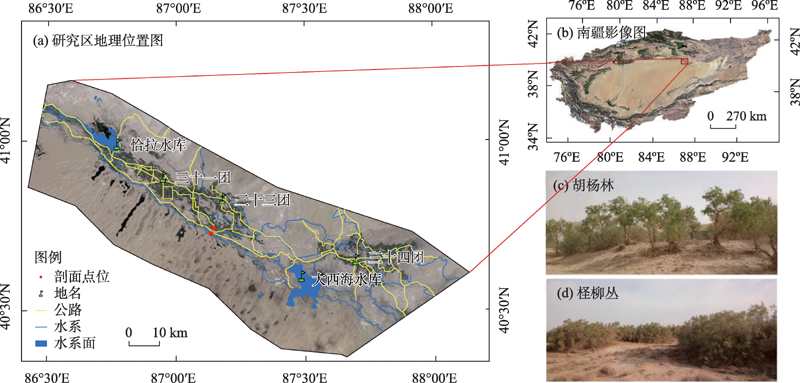
| [1] |
刘秀强, 陈喜, 刘琴, 等. 西北干旱区尾闾湖过渡带陆面蒸发和潜水对土壤水影响的同位素分析[J]. 干旱区资源与环境, 2021, 35(6): 52-59.
|
|
[ Liu Xiuqiang, Chen Xi, Liu Qin, et al. Variation of hydrogen and oxygen isotopes in soil water and soil water evaporation depth around terminal lake in arid region of Northwest China[J]. Journal of Arid Land Resources and Environment, 2021, 35(6): 52-59. ]
|
| [2] |
周燕怡, 王旭升. 巴丹吉林沙漠潜水蒸发的数值模拟研究[J]. 水文地质工程地质, 2019, 46(5): 44-54.
|
|
[ Zhou Yanyi, Wang Xusheng. Numerical simulation of groundwater evaporation in the Badain Jaran Desert of China[J]. Hydrogeology & Engineering Geology, 2019, 46(5): 44-54. ]
|
| [3] |
马稚桐, 王文科, 赵明, 等. 半干旱地区地表—地下水系统水热运移与裸土蒸发研究[J]. 水文地质工程地质, 2021, 48(4): 7-14.
|
|
[ Ma Zhitong, Wang Wenke, Zhao Ming, et al. Hydrothermal transfer and bare soil evaporation in surfacegroundwater systems in semi-arid areas[J]. Hydrogeology & Engineering Geology, 2021, 48(4): 7-14. ]
|
| [4] |
周龙, 杨鹏年, 王永鹏, 等. 塔里木河下游河段耗水特征与输水方式演变研究[J]. 干旱区研究, 2022, 39(1): 144-154.
|
|
[ Zhou Long, Yang Pengnian, Wang Yongpeng, et al. Characteristics of water consumption and the evolution of water delivery methods in the lower reach of the Tarim River[J]. Arid Zone Research, 2022, 39(1): 144-154. ]
|
| [5] |
王登, 霍思远, 孙芳, 等. 人工溴示踪法评价潜水蒸发可行性数值模拟[J]. 水文地质工程地质, 2020, 47(1): 19-27.
|
|
[ Wang Deng, Huo Siyuan, Sun Fang, et al. Numerical simulation on applicability of bromide tracer method for evaluating groundwater evaporation[J]. Hydrogeology & Engineering Geology, 2020, 47(1): 19-27. ]
|
| [6] |
邓改革, 何建国, 康宁波. 基于多物理场耦合的毛细水高度研究[J]. 水土保持研究, 2021, 28(4): 136-141.
|
|
[ Deng Gaige, He Jianguo, Kang Ningbo. Research on capillary water height based on multi-physical field coupling[J]. Research of Soil and Water Conservation, 2021, 28(4): 136-141. ]
|
| [7] |
Zhang Fuchu, Wu Bin, Gao Fan, et al. Hydrochemical characteristics of groundwater and evaluation of water quality in arid area of Northwest China: A case study in the plain area of Kuitun River Basin[J]. Arabian Journal of Geosciences, 2021, 14: 2099.
doi: 10.1007/s12517-021-08464-7
|
| [8] |
徐永亮, 于静洁, 张一驰, 等. 生态输水期间额济纳绿洲区地下水动态数值模拟[J]. 水文地质工程地质, 2014, 41(4): 11-18.
|
|
[ Xu Yongliang, Yu Jingjie, Zhang Yichi, et al. Groundwater dynamic numerical simulation in the Ejina Oasis in an ecological water conveyance period[J]. Hydrogeology & Engineering Geology, 2014, 41(4): 11-18. ]
|
| [9] |
赵明, 郭志中, 王耀琳, 等. 不同地下水位植物蒸腾耗水特性研究[J]. 干旱区研究, 2003, 20(4): 286-291.
|
|
[ Zhao Ming, Guo Zhizhong, Wang Yaolin, et al. Study on the transpiration characteristics of 10 species of plants under the different depths of groundwater level[J]. Arid Zone Research, 2003, 20(4): 286-291. ]
|
| [10] |
孙芳强, 尹立河, 马洪云, 等. 准噶尔盆地南缘土壤水运移特征及其补给来源识别[J]. 干旱区研究, 2017, 34(6): 1271- 1277.
|
|
[ Sun Fangqiang, Yin Lihe, Ma Hongyun, et al. Identification of soil water migration and recharge sources in the southern marginal zone of the Junggar Basin, China[J]. Arid Zone Research, 2017, 34(6): 1271-1277. ]
|
| [11] |
张平, 吴昊, 殷洪建, 等. 土层结构对毛细水上升高度和地下水蒸发影响的研究[J]. 节水灌溉, 2011, 36(3): 6-8.
|
|
[ Zhang Ping, Wu Hao, Yin Hongjian, et al. Research on influence of construction of soil layer on height of capillary water upward movement and evaporation of groundwater[J]. Water Saving Irrigation, 2011, 36(3): 6-8. ]
|
| [12] |
孙英, 周金龙, 齐子萱, 等. 日尺度和小时尺度下干旱区潜水蒸发变化特征及成因[J]. 灌溉排水学报, 2020, 39(增刊2): 14-19.
|
|
[ Sun Ying, Zhou Jinlong, Qi Zixuan, et al. Variation characteristics and causes of phreatic water evaporation in arid area on daily and hourly scales[J]. Journal of Irrigation and Drainage, 2020, 39 (Suppl.2): 14-19. ]
|
| [13] |
Aderonke O Adegbule, Tohren C G Kibbey. Exploring the impact of long-term evaporation on the relationship between capillary pressure and water saturation in unsaturated porous media[J]. Journal of Hydrology, 2020, 582: 124557.
doi: 10.1016/j.jhydrol.2020.124557
|
| [14] |
Xiong Lvyang, Ren Dongyang, et al. Enhancing the capability of hydrological models to simulate the regional agro-hydrological processes in watersheds with shallow groundwater: Based on the SWAT framework[J]. Journal of Hydrology, 2019, 572: 1-16.
doi: 10.1016/j.jhydrol.2019.02.043
|
| [15] |
孙海燕, 叶含春, 许丽, 等. 沙漠绿洲区平原水库下缘盐荒地水盐动态规律[J]. 干旱区研究, 2017, 34(5): 967-971.
|
|
[ Sun Haiyan, Ye Hanchun, Xu Li, et al. Water and salt migration under saline wasteland in a desert-oasis area at the lower edge of a plain reservoir[J]. Arid Zone Research, 2017, 34(5): 967-971. ]
|
| [16] |
Chen Hang, Liu Zhongyi, Huo Zailin, et al. Impacts of agricultural water saving practice on regional groundwater and water consumption in an arid region with shallow groundwater[J]. Environmental Earth Sciences, 2016, 75: 1204.
doi: 10.1007/s12665-016-6006-6
|
| [17] |
Chen Li, Wang Wenke, Zhang Zaiyong, et al. Estimation of bare soil evaporation for different depths of water table in the wind-blown sand area of the Ordos Basin, China[J]. Hydrogeology Journal, 2018, 26: 1693-1704.
doi: 10.1007/s10040-018-1774-6
|
| [18] |
余绍文, 孙自永, 周爱国, 等. 用D-O同位素确定黑河中游戈壁地区植物水分来源[J]. 中国沙漠, 2012, 32(3): 717-723.
|
|
[ Yu Shaowen, Sun Ziyong, Zhou Aiguo, et al. Determination of water sources of gobi plant by D and 18O stable iIsotopes in middle reaches of the Heihe River[J]. Journal of Desert Research, 2012, 32(3): 717-723. ]
|
| [19] |
周海, 郑新军, 唐立松, 等. 盐生荒漠土壤水稳定氢、氧同位素组成季节动态[J]. 中国沙漠, 2014, 34(1):162-169.
|
|
[ Zhou Hai, Zheng Xinjun, Tang Lisong, et al. Analysis on seasonal dynamics of δ18O and δD in soil water at a saline desert site in the southeastern Junggar Basin[J]. Journal of Desert Research, 2014, 34(1):162-169. ]
|
| [20] |
李均力, 肖昊, 沈占锋, 等. 2013—2018年塔里木河下游植被动态变化及其对生态输水的响应[J]. 干旱区研究, 2020, 37(4): 985-992.
|
|
[ Li Junli, Xiao Hao, Shen Zhanfeng, et al. Vegetation changes during the 2013-2018 period and its response to ecological water transport in the lower reaches of the Tarim River[J]. Arid Zone Research, 2020, 37(4): 985-992. ]
|
| [21] |
马斌, 梁杏, 林丹, 等. 应用2H、18O同位素示踪华北平原石家庄包气带土壤水入渗补给及年补给量确定[J]. 地质科技情报, 2014, 33(3): 163-174.
|
|
[ Ma Bin, Liang Xing, Lin Dan, et al. Tracing infiltration and recharge of the unsaturated zone using 2H,18O isotopes in Shijiazhuang,North China Plain[J]. Geological Science and Technology Information, 2014, 33(3): 163-174. ]
|
| [22] |
张文佳, 王乃昂, 于昕冉, 等. 基于地下水动态和经验模型的巴丹吉林沙漠潜水蒸发量级——以苏木吉林湖区为例[J]. 干旱区研究, 2020, 37(5): 1215-1222.
|
|
[ Zhang Wenjia, Wang Nai’ang, Yu Xinran, et al. Magnitude of groundwater evapotranspiration in the Badain Jaran Desert based on groundwater dynamics method and empirical model: A case study of the Sumujilin Lake Area[J]. Arid Zone Research, 2020, 37(5): 1215-1222. ]
|
| [23] |
于晓雯, 刘华民, 王立新, 等. 基于稳定同位素技术的黄河支流河岸植被水分来源解析[J]. 水土保持通报, 2021, 41(5): 75-82.
|
|
[ Yu Xiaowen, Liu Huamin, Wang Lixin, et al. Analysis on water sources of riverback vegetation in tributary of Yellow River based on stable isotope technique[J]. Bulletin of Soil and Water Conservation, 2021, 41(5): 75-82. ]
|
| [24] |
赵晓涵, 张方敏, 韩典辰, 等. 内蒙古半干旱区蒸散特征及归因分析[J]. 干旱区研究, 2021, 38(6): 1614-1623.
|
|
[ Zhao Xiaohan, Zhang Fangming, Han Dianchen, et al. Evapotranspiration changes and its attribution in semi-arid regions of Inner Mongolia[J]. Arid Zone Research, 2021, 38(6): 1614-1623. ]
|
| [25] |
肖红宇, 刘明寿, 彭鹏程, 等. 基于黏性土分形特征的毛细水上升高度研究[J]. 水文地质工程地质, 2016, 43(6): 48-52.
|
|
[ Xiao Hongyu, Liu Mingshou, Peng Pengcheng, et al. A study of the height of capillary water rise based on fractal characteristics of cohesive soil[J]. Hydrogeology & Engineering Geology, 2016, 43(6): 48-52. ]
|
 ),赵毅1(