干旱区研究 ›› 2024, Vol. 41 ›› Issue (3): 363-374.doi: 10.13866/j.azr.2024.03.02
王雪莹1,2( ), 谷黄河1,2(), 代斌3, 张瀚文3, 余钟波1,2
收稿日期:2023-10-18
修回日期:2023-12-24
出版日期:2024-03-15
发布日期:2024-04-01
通讯作者:
谷黄河. E-mail: ghh0001@hhu.edu.cn
作者简介:王雪莹(2000-),女,硕士研究生,主要研究方向为水文学及水资源. E-mail: wangxy07@hhu.edu.cn
基金资助:
WANG Xueying1,2(), GU Huanghe1,2(), DAI Bin3, ZHANG Hanwen3, YU Zhongbo1,2
Received:2023-10-18
Revised:2023-12-24
Online:2024-03-15
Published:2024-04-01
摘要:
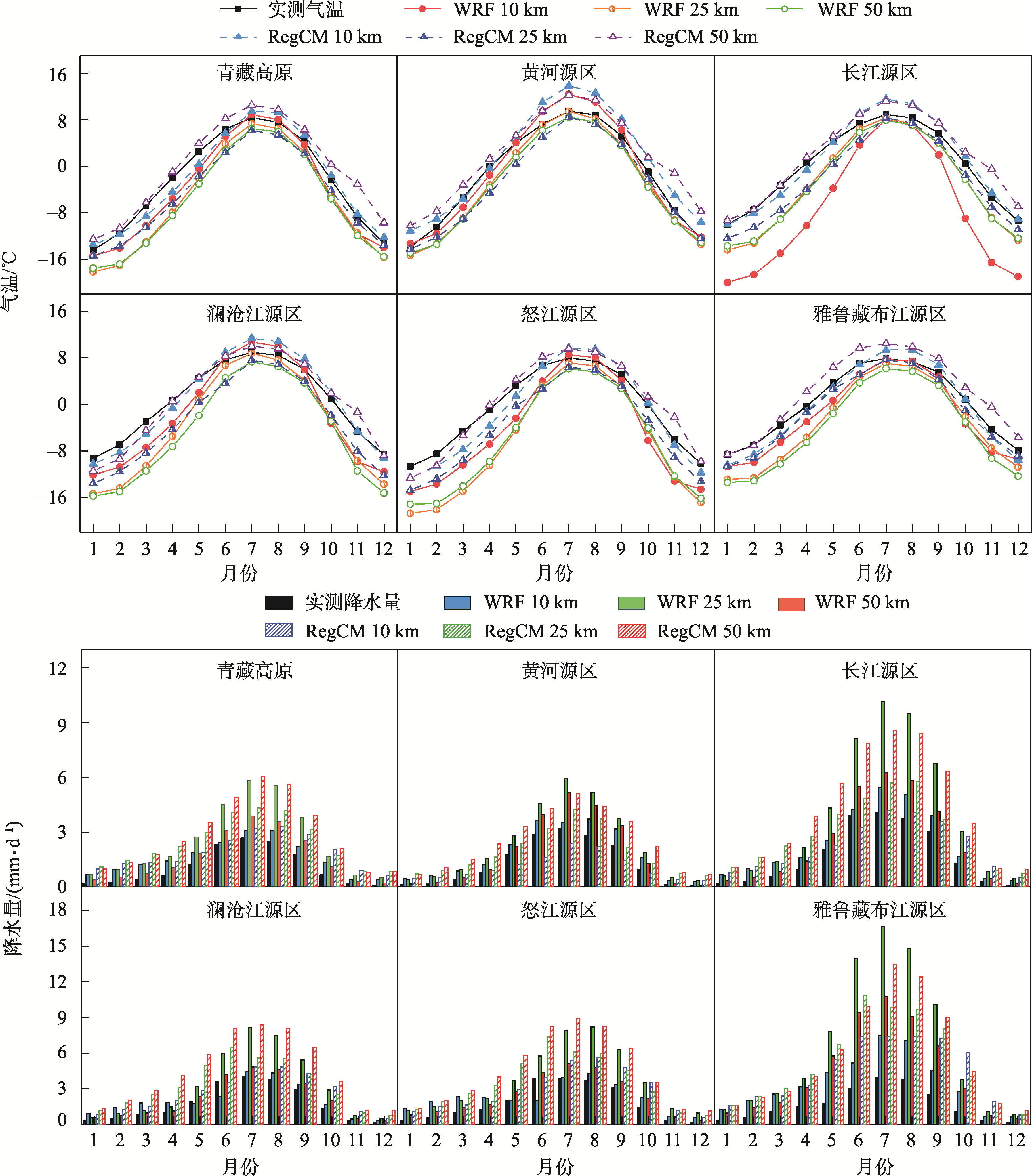
青藏高原地区气候特殊、地形复杂,气象观测站点稀少,对其区域气候和水循环过程的观测和模拟存在很大的困难。本文基于RegCM模式和WRF模式,探究不同水平分辨率10 km、25 km、50 km下区域气候模式对该地区1989—2008年气候时空分布规律的模拟能力。研究结果表明:在10 km水平分辨率下,RegCM模式模拟多年平均气温绝对误差为0.33 ℃,WRF模式模拟绝对误差为1.77 ℃,比25 km和50 km水平分辨率下绝对误差减少1.60~2.12 ℃,且四季气温模拟值与实测值的相关性有所提高;随着水平分辨率的提高,WRF模式对青藏高原东南部和南部的降水量高估有所改善,RegCM模式模拟值逐渐接近实测值(模拟年降水量相对误差由169%降至75%)且对高原北部降水量的模拟有所改善,但整体上模式对降雨的高估依然存在;两个模式随水平分辨率的提高对地形起伏最大的雅鲁藏布江源区降水量的误差减少最为明显。本研究可为揭示气候变化下青藏高原水文响应机理奠定基础。
王雪莹, 谷黄河, 代斌, 张瀚文, 余钟波. 不同水平分辨率区域气候模式对青藏高原气候特征模拟[J]. 干旱区研究, 2024, 41(3): 363-374.
WANG Xueying, GU Huanghe, DAI Bin, ZHANG Hanwen, YU Zhongbo. Simulation of climate characteristics in the Qinghai-Tibet Plateau by regional climate models at different horizontal resolutions[J]. Arid Zone Research, 2024, 41(3): 363-374.
表1
试验设计方案"
| RegCM | WRF | |
|---|---|---|
| 水平分辨率 | 10 km、25 km、50 km | 10 km、25 km、50 km |
| 经纬度范围 | 70 °~106 °E, 23 °~42 °N; 49 °~180 °E, 0 °~61 °N; 33 °E~180 °E, 24 °S~67 °N | 74 °~106 °E, 22 °~42 °N; 50 °~180 °E, 0 °~49 °N; 40 °E~180 °E, 24 °S~65 °N |
| 格点数 | 297×189、394×249、 243×197 | 277×216、395×250、 233×197 |
| 对流参数化方案 | MIT-Emanuel | Kain-Fritch Ⅱ |
| 陆面参数化方案 | CLM 3.5 | NOAH LSM |
| 行星边界层 | Hotslag | YSU |
| 谱逼近方法 | 选用 | 选用 |
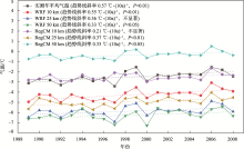
图1
WRF模式、RegCM模式不同水平分辨率下对青藏高原年平均气温模拟结果"

表2
青藏高原年均、四季气温模拟结果误差分析"
| 年均 | 春季 | 夏季 | 秋季 | 冬季 | ||
|---|---|---|---|---|---|---|
| RegCM模式10 km | MAE/℃ | 0.33 | 2.17 | 0.69 | 0.80 | 0.82 |
| RMSE/℃ | 0.44 | 2.27 | 0.79 | 1.00 | 1.04 | |
| R | 0.55 | 0.47 | 0.65 | 0.47 | 0.55 | |
| WRF模式10 km | MAE/℃ | 1.77 | 3.38 | 0.27 | 2.20 | 1.41 |
| RMSE/℃ | 1.78 | 3.40 | 0.34 | 2.24 | 1.47 | |
| R | 0.91 | 0.87 | 0.71 | 0.73 | 0.93 | |
| RegCM模式25 km | MAE/℃ | 2.45 | 4.20 | 2.80 | 1.67 | 1.14 |
| RMSE/℃ | 2.48 | 4.24 | 2.86 | 1.83 | 1.29 | |
| R | 0.75 | 0.67 | 0.50 | 0.19 | 0.81 | |
| WRF模式25 km | MAE/℃ | 3.37 | 5.65 | 1.54 | 2.40 | 3.92 |
| RMSE/℃ | 3.38 | 5.65 | 1.55 | 2.43 | 3.95 | |
| R | 0.93 | 0.96 | 0.92 | 0.84 | 0.91 | |
| RegCM模式50 km | MAE/℃ | 2.13 | 0.96 | 2.06 | 3.44 | 2.42 |
| RMSE/℃ | 2.15 | 1.00 | 2.07 | 3.47 | 2.82 | |
| R | 0.93 | 0.89 | 0.87 | 0.15 | 0.70 | |
| WRF模式50 km | MAE/℃ | 3.77 | 6.20 | 2.39 | 2.91 | 3.74 |
| RMSE/℃ | 3.79 | 6.24 | 2.41 | 2.95 | 3.86 | |
| R | 0.72 | 0.73 | 0.79 | 0.01 | 0.63 |

图2
WRF模式、RegCM模式不同水平分辨率下对青藏高原年降水量模拟结果"

表3
青藏高原年均、四季降水量模拟结果误差分析"
| 年均 | 春季 | 夏季 | 秋季 | 冬季 | ||
|---|---|---|---|---|---|---|
| RegCM模式10 km | BIAS/% | 75 | 102 | 22 | 126 | 532 |
| MAE/mm | 290.7 | 70.6 | 49.3 | 98.3 | 73.3 | |
| RMSE/mm | 293.1 | 72.2 | 55.3 | 99.0 | 74.5 | |
| R | 0.69 | 0.28 | 0.60 | 0.48 | 0.62 | |
| WRF模式10 km | BIAS/% | 50 | 101 | 15 | 55 | 342 |
| MAE/mm | 195.4 | 69.9 | 35.4 | 42.5 | 47.2 | |
| RMSE/mm | 201.3 | 71.2 | 43.0 | 44.5 | 47.7 | |
| R | 0.37 | 0.08 | 0.63 | 0.03 | 0.50 | |
| RegCM模式25 km | BIAS/% | 125 | 210 | 68 | 123 | 640 |
| MAE/mm | 486.0 | 145.9 | 156.4 | 96.1 | 88.1 | |
| RMSE/mm | 489.5 | 146.8 | 161.1 | 97.2 | 88.5 | |
| R | -0.08 | 0.09 | -0.05 | 0.03 | 0.57 | |
| WRF模式25 km | BIAS/% | 134 | 151 | 113 | 139 | 365 |
| MAE/mm | 523.0 | 104.9 | 259.0 | 108.2 | 50.3 | |
| RMSE/mm | 524.6 | 105.4 | 261.1 | 108.9 | 51.0 | |
| R | 0.73 | 0.65 | 0.80 | 0.55 | 0.21 | |
| RegCM模式50 km | BIAS/% | 169 | 246 | 122 | 165 | 565 |
| MAE/mm | 658.8 | 170.5 | 279.5 | 128.4 | 77.9 | |
| RMSE/mm | 659.5 | 170.8 | 280.1 | 129.3 | 79.8 | |
| R | 0.83 | 0.76 | 0.83 | 0.52 | 0.29 | |
| WRF模式50 km | BIAS/% | 51 | 60 | 42 | 51 | 135 |
| MAE/mm | 197.2 | 41.6 | 95.4 | 40.1 | 18.5 | |
| RMSE/mm | 204.2 | 44.3 | 99.1 | 42.2 | 20.4 | |
| R | 0.28 | 0.05 | 0.57 | 0.45 | 0.19 |
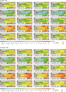
图3
WRF模式(a)、RegCM模式(b)不同水平分辨率下对青藏高原年平均、四季气温模拟空间分布"

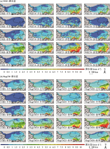
图4
WRF模式(a)、RegCM模式(b)不同水平分辨率下对青藏高原年、四季降水量模拟空间分布"

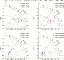
图5
不同水平分辨率下区域气候模式模拟的四季气温(a、b)、四季降水量(c、d)泰勒分析 注:图中点标记底色为彩色、字体为白色即代表该点模拟偏差的绝对值为3种分辨率中此季节模拟偏差绝对值的最小值。"

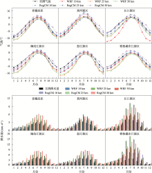
图6
不同水平分辨率下区域气候模式在青藏高原五大江河源区模拟的多年月平均气温(上)、多年月平均降水量(下)"
| [1] | Duan A, Wu G. Change of cloud amount and the climate warming on the Tibetan Plateau[J]. Geophysical Research Letters, 2006, 33(22): 217-234. |
| [2] | 杨昭明, 张调风. 1961—2017年青藏高原东北部雨季降水量变化及其贡献度分析[J]. 干旱区研究, 2021, 38(1): 22-28. |
| [Yang Zhaoming, Zhang Tiaofeng. Analysis of precipitation change and its contribution in the rainy season in the northeast Qinghai-Tibet Plateau from 1961 to 2017[J]. Arid Zone Research, 2021, 38(1): 22-28.] | |
| [3] |
Liu X, Chen B. Climatic warming in the Tibetan Plateau during recent decades[J]. International Journal of Climatology, 2000, 20(14): 1729-1742.
doi: 10.1002/(ISSN)1097-0088 |
| [4] |
杨耀先, 胡泽勇, 路富全, 等. 青藏高原近60年来气候变化及其环境影响研究进展[J]. 高原气象, 2022, 41(1): 1-10.
doi: 10.7522/j.issn.1000-0534.2021.00117 |
|
[Yang Yaoxian, Hu Zeyong, Lu Fuquan, et al. Progress of recent 60 years’ climate change and its environmental impacts on the Qinghai-Xizang Plateau[J]. Plateau Meteorology, 2022, 41(1): 1-10.]
doi: 10.7522/j.issn.1000-0534.2021.00117 |
|
| [5] | Wang A, Zeng X. Evaluation of multireanalysis products with in situ observations over the Tibetan Plateau[J]. Journal of Geophysical Research: Atmospheres, 2012, 117(D5): 2011JD016553. |
| [6] |
Giorgi F, Gutowski W J. Regional dynamical downscaling and the CORDEX initiative[J]. Annual Review of Environment and Resources, 2015, 40: 467-490.
doi: 10.1146/energy.2015.40.issue-1 |
| [7] |
Gao X, Giorgi F. Use of the RegCM system over east Asia: Review and Perspectives[J]. Engineering, 2017, 3(5): 766-772.
doi: 10.1016/J.ENG.2017.05.019 |
| [8] | 王澄海, 余莲. 区域气候模式对不同的积云参数化方案在青藏高原地区气候模拟中的敏感性研究[J]. 大气科学, 2011, 35(6): 1132. |
| [Wang Chenghai, Yu Lian. Sensitivity of regional climate model to different cumulus parameterization schemes in simulation of the Tibetan Plateau climate[J]. Chinese Journal of Atmospheric Sciences, 2011, 35(6): 1132-1144.] | |
| [9] |
吴遥, 李跃清, 蒋兴文, 等. WRF模拟青藏高原东南部极端旱涝年降水的参数敏感性研究[J]. 高原气象, 2017, 36(3): 619-631.
doi: 10.7522/j.issn.1000-0534.2016.00057 |
|
[Wu Yao, Li Yueqing, Jiang Xingwen, et al. Parameters sensitivity analysis on simulation of rainfall in drought-flood year on Qinghai-Tibetan Plateau by WRF model[J]. Plateau Meteorology, 2017, 36(3): 619-631.]
doi: 10.7522/j.issn.1000-0534.2016.00057 |
|
| [10] | 吕光辉, 于恩涛, 向伟玲, 等. WRF模式分辨率对新疆异常降雨天气要素模拟的影响[J]. 气候与环境研究, 2009, 14(1): 85-96. |
| [Lü Guanghui, Yu Entao, Xiang Weiling, et al. Effect of horizontal and vertical resolution on WRF simulation of the unusual rainfall event in Xinjiang[J]. Climatic and Environmental Research, 2009, 14(1): 85-96.] | |
| [11] | 刘金波, 曾新民, 郑益群. 区域气候模式分辨率对中国夏季气温模拟影响的评估[J]. 气象学报, 2011, 69(3): 534-543. |
| [Liu Jinbo, Zeng Xinmin, Zheng Yiqun. An assessment of the effects of the resolution of a regional climate model on simulated summer temperatures in China[J]. Acta Meteorologica Sinica, 2011, 69(3): 534-543.] | |
| [12] |
Xuan Q, Qian X, Yao Y, et al. Validation of the WRF model for estimating precipitable water vapor at the Ali observatory on the Tibetan Plateau[J]. Publications of the Astronomical Society of the Pacific, 2020, 132(1018): 125003.
doi: 10.1088/1538-3873/abc22d |
| [13] | 张芳华, 马旭林, 杨克明. 2003年6月24—25日江南特大暴雨数值模拟和诊断分析[J]. 气象, 2004, 30(1): 28-33. |
| [Zhang Fanghua, Ma Xulin, Yang Keming. Numerical simulation and diagnostic analysis of a heavy rainfall in Jiangnan area during 24-25 June 2003[J]. Meteorological Monthly, 2004, 30(1): 28-33.] | |
| [14] | 何由, 阳坤, 姚檀栋, 等. 基于WRF模式对青藏高原一次强降水的模拟[J]. 高原气象, 2012, 31(5): 1183-1191. |
| [He You, Yang Kun, Yao Tandong, et al. Numerical simulation of a heavy precipitation in Qinghai-Xizang Plateau based on WRF model[J]. Plateau Meteorology, 2012, 31(5): 1183.] | |
| [15] |
Gao Y H, Xu J W, Chen D L, et al. Evaluation of WRF mesoscale climate simulations over the Tibetan Plateau during 1979-2011[J]. Journal of Climate, 2015, 28: 2823-2841.
doi: 10.1175/JCLI-D-14-00300.1 |
| [16] | 梁玲, 李跃清, 胡豪然, 等. RegCM3模式对青藏高原温度和降水的模拟及检验[J]. 气象科学, 2009, 29(5): 611-617. |
| [Liang Ling, Li Yueqing, Hu Haoran, et al. Simulation of air temperature and precipitation over Qinghai-Xizang Plateau with RegCM3 model[J]. Journal of the Meteorological Sciences, 2009, 29(5): 611-617.] | |
| [17] |
韩振宇, 高学杰, 徐影. 多区域模式集合的东亚陆地区域的平均和极端降水未来预估[J]. 地球物理学报, 2021, 64(6): 1869-1884.
doi: 10.6038/cjg2021O0103 |
| [Han Zhenyu, Gao Xuejie, Xu Ying. Mean and extreme precipitation projection over land area of East Asia based on multiple regional climate models[J]. Chinese Journal of Geophysics, 2021, 64(6): 1869-1884.] | |
| [18] |
Gu H, Yu Z, Peltier W R, et al. Sensitivity studies and comprehensive evaluation of RegCM4.6.1 high-resolution climate simulations over the Tibetan Plateau[J]. Climate Dynamics, 2020, 54(7-8): 3781-3801.
doi: 10.1007/s00382-020-05205-6 |
| [19] |
He J, Yang K, Tang W, et al. The first high-resolution meteorological forcing dataset for land process studies over China[J]. Scientific Data, 2020, 7: 25.
doi: 10.1038/s41597-020-0369-y pmid: 31964891 |
| [20] |
Yang K, He J, Tang W J, et al. On downward shortwave and longwave radiations over high altitude regions: Observation and modeling in the Tibetan Plateau[J]. Agricultural and Forest Meteorology, 2010, 150: 38-46.
doi: 10.1016/j.agrformet.2009.08.004 |
| [21] | 阳坤, 何杰, 唐文君, 等. 中国区域地面气象要素驱动数据集(1979-2018)[DB/OL]. 国家青藏高原科学数据中心, 2019. https://doi.org/10.11888/AtmosphericPhysics.tpe.249369.file. |
| [Yang Kun, He Jie, Tang Wenjun, et al. China meteorological forcing dataset (1979-2018)[DB/OL]. National Tibetan Plateau/ Third Pole Environment Data Center, 2019. https://doi.org/10.11888/AtmosphericPhysics.tpe.249369.file.] | |
| [22] | 温婷婷, 郭英香, 董少睿, 等. 1979—2017年CRU、ERA5、CMFD格点降水数据在青藏高原适用性评估[J]. 干旱区研究, 2022, 39(3): 684-697. |
| [Wen Tingting, Guo Yingxiang, Dong Shaorui, et al. Assessment of CRU, ERA5, CMFD grid precipitation data for the Tibetan Plateau from 1979 to 2017[J]. Arid Zone Research, 2022, 39(3): 684-697.] | |
| [23] | 吴阳. 夏季青藏高原湖泊群区域气候效应及其作用机理的数值模拟研究[D]. 南京: 南京大学, 2018. |
| [Wu Yang. Numerical Study of the Regional Climate Effect of Lake Clusters in Tibetan Plateau and Its Working Mechanisms during Summer[D]. Nanjing: Nanjing University, 2008.] | |
| [24] |
Taylor K E. Summarizing multiple aspects of model performance in a single diagram[J]. Journal of Geophysical Research: Atmospheres, 2001, 106(D7): 7183-7192.
doi: 10.1029/2000JD900719 |
| [25] | 胡清静. 甘肃省1959-2006年气候及主要河流径流特征分析[D]. 兰州: 兰州大学, 2011. |
| [Hu Qingjing. Characteristic of Climate and Runoff of Main Rivers in Gansu during 1959-2006[D]. Lanzhou: Lanzhou University, 2011.] | |
| [26] | 胡芩, 姜大膀, 范广洲. CMIP5全球气候模式对青藏高原地区气候模拟能力评估[J]. 大气科学, 2014, 38(5): 924-938. |
| [Hu Qin, Jiang Dabang, Fan Guangzhou. Evaluation of CMIP5 models over the Qinghai-Tibetan Plateau[J]. Chinese Journal of Atmospheric Sciences, 2014, 38(5): 924-938.] | |
| [27] |
New M, Hulme M, Jones P. Representing twentieth-century space-time climate variability. Part I: Development of a 1961-90 mean monthly terrestrial climatology[J]. Journal of Climate, 1999, 12(3): 829-856.
doi: 10.1175/1520-0442(1999)012<0829:RTCSTC>2.0.CO;2 |
| [28] |
Rahimi S R, Wu C, Liu X, et al. Exploring a variable-resolution approach for simulating regional climate over the Tibetan Plateau using VR-CESM[J]. Journal of Geophysical Research: Atmospheres, 2019, 124(8): 4490-4513.
doi: 10.1029/2018JD028925 |
| [29] |
Ou T, Chen D, Chen X, et al. Simulation of summer precipitation diurnal cycles over the Tibetan Plateau at the gray-zone grid spacing for cumulus parameterization[J]. Climate Dynamics, 2020, 54: 3525-3539.
doi: 10.1007/s00382-020-05181-x |
| [30] |
Fu Y, Ma Y, Zhong L, et al. Land-surface processes and summer-cloud-precipitation characteristics in the Tibetan Plateau and their effects on downstream weather: A review and perspective[J]. National Science Review, 2020, 7(3): 500-515.
doi: 10.1093/nsr/nwz226 pmid: 34692070 |
| [31] | Zhao D, Lin Y, Dong W, et al. Alleviated WRF summer wet bias over the Tibetan Plateau using a new cloud macrophysics scheme[J]. Journal of Advances in Modeling Earth Systems, 2023, 15(10): e2023MS003616. |
| [32] | 熊喆, 宋长青. 对流解析区域气候模式对青藏高原降水模拟能力的研究[J]. 北京师范大学学报(自然科学版), 2022, 58(2): 337-347. |
| [Xiong Zhe, Song Changqing. Convection-permitting regional climate model to simulate precipitation in the Qinghai-Tibet Plateau[J]. Journal of Beijing Normal University (Natural Science), 2022, 58(2): 337-347.] | |
| [33] | 高艳红, 许建伟, 张萌, 等. 青藏高原气候动力降尺度——从1/4度到公里尺度[J]. 中国科学: 地球科学, 2022, 32(12): 2342-2352. |
| [Gao Yanhong, Xu Jianwei, Zhang Meng, et al. Regional climate dynamical downscaling over the Tibetan Plateau—From quarter-degree to kilometer-scale[J]. Scientia Sinica (Terrae), 2022, 32(12): 2237-2247.] |
| [1] | 许宁, 李治国, 梁雪悦, 周晓莹. 基于地形梯度的青藏高原冰川分布格局及成因[J]. 干旱区研究, 2024, 41(2): 230-239. |
| [2] | 申红艳, 温婷婷, 赵仙荣, 冯晓莉. 基于多模式的青藏高原前冬降水预测性能评估[J]. 干旱区研究, 2023, 40(7): 1027-1039. |
| [3] | 关宇淇, 李广, 潘雪, 徐国荣, 魏星星, 刘昊, 吴江琪. 降雨频率对甘南尕海湿草甸土壤碳氮磷化学计量特征的影响[J]. 干旱区研究, 2023, 40(6): 916-925. |
| [4] | 王鹏, 秦思彤, 胡慧蓉. 近30 a拉萨河流域土地利用变化和生境质量的时空演变特征[J]. 干旱区研究, 2023, 40(3): 492-503. |
| [5] | 温婷婷,郭英香,董少睿,东元祯,来晓玲. 1979—2017年CRU、ERA5、CMFD格点降水数据在青藏高原适用性评估[J]. 干旱区研究, 2022, 39(3): 684-697. |
| [6] | 张君霞,孔祥伟,刘新伟,王勇. 青藏高原东北侧暴雨数值模式预报空间误差特征[J]. 干旱区研究, 2022, 39(1): 64-74. |
| [7] | 席文涛,高晶. 基于地理探测器分析青藏高原降水δ18O空间分异特征[J]. 干旱区研究, 2021, 38(5): 1199-1206. |
| [8] | 张海亮,李火青,买买提艾力·买买提依明. 新疆夏季行星边界层参数化方案模拟特征研究[J]. 干旱区研究, 2021, 38(1): 154-162. |
| [9] | 魏倩,隆霄,赵建华,韩子霏,王思懿. 边界层参数化方案对一次西北地区沙尘天气过程影响的数值模拟研究[J]. 干旱区研究, 2021, 38(1): 163-177. |
| [10] | 杨昭明,张调风. 1961—2017年青藏高原东北部雨季降水量变化及其贡献度分析[J]. 干旱区研究, 2021, 38(1): 22-28. |
| [11] | 丁明月, 王俐俐, 辛 渝, 刘 琼, 陈勇航, 张广兴, 杨莲梅, 梁 倩, 黄 观, 刘统强. 基于CloudSat卫星资料对中亚低涡暴雨个例的诊断分析和数值模拟[J]. 干旱区研究, 2020, 37(4): 936-946. |
| [12] | 王坤鑫, 张寅生, 张腾, 余坤伦, 郭燕红, 马宁. 1979—2017年青藏高原色林错流域气候变化分析[J]. 干旱区研究, 2020, 37(3): 652-. |
| [13] | 丁明月, 王俐俐, 辛渝, 陈勇航, 杨莲梅, 梁倩, 刘琼, 刘统强. WRF云微物理参数化方案对新疆暴雨模拟能力的TS评分分析[J]. 干旱区研究, 2019, 36(6): 1411-1418. |
| [14] | 金孙梅, 侯光良, 许长军, 兰措卓玛, 李生梅. 全新世以来青藏高原文化遗址时空演变及其驱动 [J]. 干旱区研究, 2019, 36(5): 1049-1059. |
| [15] | 祁艳, 颜玉倩, 李金海, 陈汶江. 青藏高原5—10月地表潜热通量与青海同期降水之间的关系[J]. 干旱区研究, 2019, 36(3): 529-536. |
|
||