干旱区研究 ›› 2022, Vol. 39 ›› Issue (1): 64-74.doi: 10.13866/j.azr.2022.01.07
张君霞( ),孔祥伟(),刘新伟,王勇
收稿日期:2021-04-24
修回日期:2021-06-02
出版日期:2022-01-15
发布日期:2022-01-24
通讯作者:
孔祥伟
作者简介:张君霞(1990-),女,硕士,主要从事模式降水客观订正方法的研究. E-mail: 基金资助:
ZHANG Junxia(),KONG Xiangwei(),LIU Xinwei,WANG Yong
Received:2021-04-24
Revised:2021-06-02
Online:2022-01-15
Published:2022-01-24
Contact:
Xiangwei KONG
摘要:
利用2019—2020年5—9月ECMWF(European Center for Medium-Range Weather Forecast)、GRAPES-GFS(中国气象局GRAPES全球数值预报业务系统,Global/Regional Assimilation and Prediction System-Global Forecast System)大尺度数值模式36 h预报时效的24 h降水量预报和加密降水观测资料,基于CRA空间检验技术识别、分离青藏高原东北侧暴雨目标(ECMWF模式18个,GRAPES-GFS模式11个),定量分析了两种模式对暴雨预报的空间误差(落区、强度和形态误差)特征,总结大尺度数值模式在青藏高原东北侧暴雨预报中的适用性。结果表明:(1) 两种模式的降水预报形态误差占比均最大。ECMWF预报的强度误差占比最小,落区误差次之,而GRAPES-GFS的落区误差占比最小,强度误差次之。(2) 两种模式预报的暴雨落区位置均较实况偏西偏北。暴雨大值中心ECMWF偏西偏南,而GRAPES-GFS仅偏西。(3) 对暴雨雨区面积的预报两种模式均明显偏小,容易造成暴雨漏报,对最大降水量和平均雨强的预报GRAPES-GFS模式均偏弱超过40%,ECMWF预报的平均雨强偏弱11.49%,最大降水量偏强1.47%。(4) 两种模式对甘肃陇东南地区和陕西西南部的暴雨预报效果较好,而对陕北及宁夏等偏北地区的预报效果较差。
张君霞,孔祥伟,刘新伟,王勇. 青藏高原东北侧暴雨数值模式预报空间误差特征[J]. 干旱区研究, 2022, 39(1): 64-74.
ZHANG Junxia,KONG Xiangwei,LIU Xinwei,WANG Yong. Spatial error characteristics of rainstorm forecasts of large-scale numerical model over the northeastern side of Tibetan Plateau[J]. Arid Zone Research, 2022, 39(1): 64-74.
表1
2019—2020年5—9月青藏高原东北侧暴雨天气过程、暴雨雨区面积及有效CRA统计"
| 暴雨天气过程 (年-月-日) | 暴雨区面积/km2 | 是否识别有效CRA ECMWF GRAPES-GFS | 暴雨天气过程 (年-月-日) | 暴雨区面积/km2 | 是否识别有效CRAECMWF GRAPES-GFS | ||
|---|---|---|---|---|---|---|---|
| 2019-05-05 | 1709 | × | × | 2020-06-16 | 61783 | √ | √ |
| 2019-05-06 | 1832 | × | × | 2020-06-25 | 20154 | √ | × |
| 2019-06-04 | 13312 | √ | √ | 2020-07-10 | 11445 | √ | √ |
| 2019-06-05 | 9688 | × | × | 2020-07-11 | 2786 | × | × |
| 2019-06-20 | 15609 | √ | √ | 2020-07-23 | 16981 | × | × |
| 2019-06-27 | 33730 | × | × | 2020-07-24 | 11289 | √ | × |
| 2019-07-21 | 21002 | √ | × | 2020-08-03 | 3623 | × | × |
| 2019-07-28 | 6618 | × | × | 2020-08-04 | 39610 | √ | × |
| 2019-08-02 | 25670 | √ | √ | 2020-08-05 | 2159 | × | × |
| 2019-08-03 | 26854 | √ | √ | 2020-08-06 | 12724 | √ | × |
| 2019-08-08 | 4682 | × | × | 2020-08-07 | 2598 | × | × |
| 2019-08-19 | 1235 | × | × | 2020-08-10 | 6267 | × | × |
| 2019-08-26 | 11970 | √ | × | 2020-08-12 | 14230 | √ | √ |
| 2019-09-09 | 38960 | √ | √ | 2020-08-14 | 2200 | × | × |
| 2019-09-12 | 19184 | √ | × | 2020-08-15 | 44730 | √ | √ |
| 2019-09-13 | 10496 | × | × | 2020-08-16 | 19860 | √ | √ |
| 2019-09-14 | 55048 | √ | √ | 2020-08-17 | 4709 | × | × |
| 2020-05-07 | 5017 | × | × | 2020-08-23 | 7802 | × | × |
| 2020-06-15 | 3405 | × | × | ||||
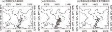
图1
2019年6月4日08:00至5日08:00≥50 mm降水及识别的CRA分布 注:图(a)、(c)中阴影区为实况,等值线为相应的ECMWF预报;图(b)填值“1、2、3、4、5”代表5个不同的CRA,其中“3”为有效CRA。"
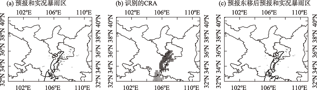
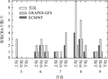
图2
青藏高原东北侧暴雨天气过程逐旬分布"

表2
暴雨落区、强度平均误差及落区、强度、形态误差平均占比统计"
| 平均面积 误差/% | 平均雨强 误差/% | 最大降水量误差/% | 总降水量 误差/% | 落区误差 占比/% | 强度误差 占比/% | 形态误差 占比/% | 平均纬向 位移误差/(°) | 平均经向 位移误差/(°) | 平均纬向 质心误差/(°) | 平均经向 质心误差/(°) | |
|---|---|---|---|---|---|---|---|---|---|---|---|
| ECMWF | -16.20 | -11.49 | 1.47 | 3.51 | 26.93 | 20.73 | 52.36 | -0.34 | 0.08 | -0.36 | -0.11 |
| GRAPES-GFS | -68.33 | -43.40 | -49.33 | -79.72 | 16.33 | 31.23 | 52.58 | -0.15 | 0.10 | -0.22 | 0.03 |
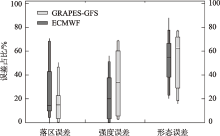
图3
青藏高原东北侧暴雨天气过程落区、强度和形态误差占比"

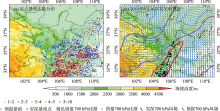
图4
青藏高原东北侧2019—2020年5—9月暴雨次数(a)及2020年8月16日暴雨实况、预报(b) 注:图(b)为2020年8月16日08:00至17日08:00暴雨、16日20:00风场(m·s-1)和比湿(g·kg-1)。"

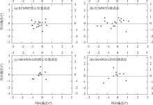
图5
ECMWF和GRAPES-GFS模式暴雨预报较实况雨区的质心位置误差(a、c)和位移误差(b、d)散点分布"

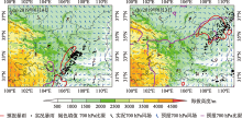
图6
2019年6月4日(a)和2019年8月3日(b)暴雨过程实况与模式预报 注:图(a)为2019年6月4日08:00至5日08:00暴雨、4日20:00 700 hPa风场(m·s-1)和比湿(g·kg-1);图(b)为2019年8月3日08:00至4日08:00暴雨、3日20:00 700 hPa风场(m·s-1)和比湿(g·kg-1)。"

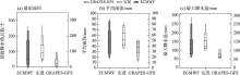
图7
暴雨的实况和模式预报的箱线图"
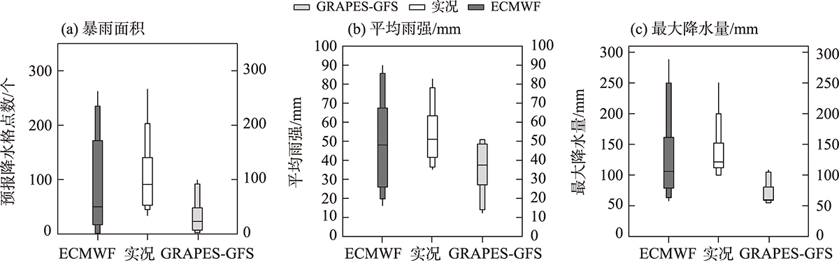

图8
ECMWF(a、b、c、d)和GRAPES-GFS(e、f、g、h)模式预报和实况暴雨面积、强度散点图"
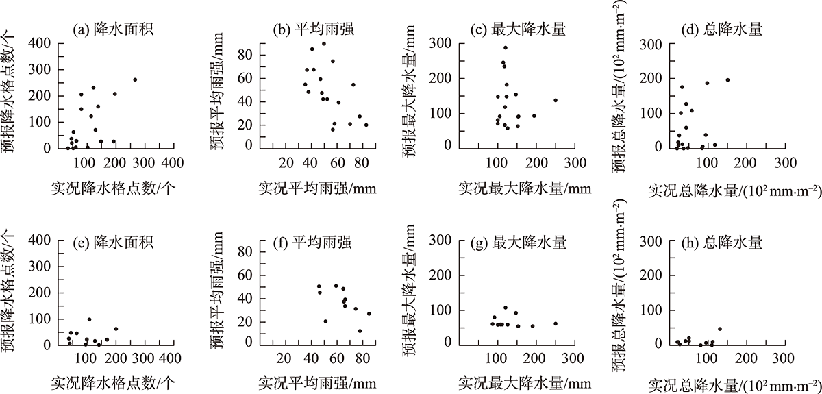
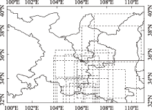
图9
ECMWF的有效CRA位置分布 注:虚线表示有效CRA所在的经纬度范围。"
表3
暴雨雨区面积、平均雨强、最大降水量偏差频次分布"
| 平均雨强 | 最大降水量 | ||||||||
|---|---|---|---|---|---|---|---|---|---|
| 偏弱 | 命中 | 偏强 | 偏弱 | 命中 | 偏强 | ||||
| 面积 | 偏大 | ECMWF | 0 | 0 | 3 | 0 | 2 | 1 | |
| GRAPES-GFS | 0 | 0 | 0 | 0 | 0 | 0 | |||
| 命中 | ECMWF | 0 | 1 | 5 | 0 | 2 | 4 | ||
| GRAPES-GFS | 0 | 2 | 0 | 2 | 0 | 0 | |||
| 偏小 | ECMWF | 7 | 2 | 0 | 8 | 2 | 0 | ||
| GRAPES-GFS | 8 | 1 | 0 | 7 | 2 | 0 | |||
| [1] | 王万筠, 殷海涛, 赵敬红, 等. 2014—2016年数值降水预报在天津的检验评估[J]. 气象科技, 2018, 46(4): 718-723. |
| [Wang Wanjun, Yin Haitao, Zhao Jinghong, et al. Verification of numerical forecast products for TainJin precipitation forecast in recent three years[J]. Meteorological Science and Technology, 2018, 46(4): 718-723. ] | |
| [2] |
Ebert E E, Mcbride J L. Verification of precipitation in weather systems: Determination of systematic errors[J]. Journal of Hydrology, 2000, 239(1): 179-202.
doi: 10.1016/S0022-1694(00)00343-7 |
| [3] | 崔粉娥, 王勇, 李慧君. 多家数值产品沿海大暴雨预报性能检验[J]. 气象科技, 2013, 41(4): 696-702. |
| [Cui Fen’e, Wang Yong, Li Huijun. Performance verification of coastal torrential rainfall forecast with several numerical products[J]. Meteorological Science and Technology, 2013, 41(4): 696-702. ] | |
| [4] | Davis C A, Brown B G, Bullock R, et al. The method for object-based diagnostic evaluation (MODE) applied to numerical forecasts from the 2005 NSSL/SPC Spring Program[J]. Weather & Forecasting, 2009, 24(5): 1252-1267. |
| [5] | 戴建华, 茅懋, 邵玲玲, 等. 强对流天气预报检验新方法在上海的应用尝试[J]. 气象科技进展, 2013, 3(3): 42-47. |
| [Dai Jianhua, Mao Mao, Shao Lingling, et al. Applications of a new verification method for severe convection forecasting and nowcasting in Shanghai[J]. Advances in Meteorological Science and Technology, 2013, 3(3): 42-47. ] | |
| [6] | 刘凑华, 牛若芸. 基于目标的降水检验方法及应用[J]. 气象, 2013, 39(6): 681-690. |
| [Liu Couhua, Niu Ruoyun. Object-based precipitation verification method and its application[J]. Meteorological Applications, 2013, 39(6): 681-690. ] | |
| [7] |
Davis C, Brown B, Bullock R. Object-based verification of precipitation forecasts. Part I: Methodology and application to mesoscale rain areas[J]. Monthly Weather Review, 2006, 134(7): 1772-1784.
doi: 10.1175/MWR3145.1 |
| [8] |
Davis C, Brown B, Bullock R. Object-based verification of precipitation forecasts. Part II: Application to convective rain systems[J]. Monthly Weather Review, 2006, 134(7): 1785-1795.
doi: 10.1175/MWR3146.1 |
| [9] | Marzban C, Sandgathe S. Cluster analysis for verification of precipitation fields[J]. Weather & Forecasting, 2006, 21(5): 824-838. |
| [10] |
Gilleland E, Lee T C, Halley G J, et al. Computationally efficient spatial forecast verification using Baddeley’s delta image metric[J]. Monthly Weather Review, 2008, 136(5): 1747-1757.
doi: 10.1175/2007MWR2274.1 |
| [11] |
Wernli H, Paulat M, Hagen M, et al. SAL: A novel quality measure for the verification of quantitative precipitation forecasts[J]. Monthly Weather Review, 2008, 136(11): 4470-4487.
doi: 10.1175/2008MWR2415.1 |
| [12] | Wernli H, Hofmann C, Zimmer M. Spatial forecast verification methods intercomparison project: Application of the SAL technique[J]. Weather & Forecasting, 2009, 24(6): 1472-1484. |
| [13] | 赵滨, 张博. 邻域空间检验方法在降水评估中的应用[J]. 暴雨灾害, 2017, 36(6): 497-504. |
| [Zhao Bin, Zhang Bo. Application of neighborhood spatial verification method on precipitation evaluation[J]. Torrential Rain and Disasters, 2017, 36(6): 497-504. ] | |
| [14] |
Ebert E E, Damrath U, Wergen W, et al. The WGNE assessment of short-term quantitative precipitation forecasts (QPFs) from operational numerical weather prediction models[J]. Bulletin of the American Meteorological Society, 2003, 84(4): 481-492.
doi: 10.1175/BAMS-84-4-Ebert |
| [15] |
Sharma K, Ashrit R, Ebert E, et al. Assessment of Met Office Unified Model (UM) quantitative precipitation forecasts during the Indian summer monsoon: Contiguous Rain Area (CRA) approach[J]. Journal of Earth System Science, 2019, 128(1): 1-17.
doi: 10.1007/s12040-018-1037-x |
| [16] |
Das A K, Kundu P K, Roy B, et al. Performance evaluation of WRF model with different cumulus parameterizations in forecasting monsoon depressions[J]. Mausam, 2019, 70(3): 501-522.
doi: 10.54302/mausam.v70i3 |
| [17] | 符娇兰, 代刊. 基于CRA空间检验技术的西南地区东部强降水EC模式预报误差分析[J]. 气象, 2016, 42(12): 1456-1464. |
| [Fu Jiaolan, Dai Kan. The ECMWF model precipitation systematic error in the east of Southwest China based on the contiguous rain area method for spatial forecast verification[J]. Meteorological Applications, 2016, 42(12): 1456-1464. ] | |
| [18] | 王新敏, 栗晗. 多数值模式对台风暴雨过程预报的空间检验评估[J]. 气象, 2020, 46(6): 753-764. |
| [Wang Xinmin, Li Han. Spatial verification evaluation of Typhoon rainstorm by multiple numerical models[J]. Meteorological Applications, 2020, 46(6): 753-764. ] | |
| [19] | Yu Z, Chen Y J, Ebert B, et al. Benchmark rainfall verification of landfall tropical cyclone forecasts by operational ACCESS-TC over China[J]. Meteorological Applications, 2020, 27: e1842. |
| [20] |
Zhuang Y, Tang X, Wang Y. Impact of track forecast error on tropical cyclone quantitative precipitation forecasts over the coastal region of China[J]. Journal of Hydrology, 2020, 589: 125347.
doi: 10.1016/j.jhydrol.2020.125347 |
| [21] | 李栋梁, 邵鹏程, 王慧, 等. 中国东亚副热带夏季风北边缘带研究进展[J]. 高原气象, 2013, 32(1): 305-314. |
| [Li Dongliang, Shao Pengcheng, Wang Hui, et al. Advances in research of the north boundary belt of East Asia Subtropical Summer Monsoon in China[J]. Plateau Meteorology, 2013, 32(1): 305-314. ] | |
| [22] | 陈婕, 黄伟, 靳立亚, 等. 东亚夏季风的气候北界指标及其年际变化研究[J]. 中国科学: 地球科学, 2018, 48(1): 93-101. |
| [Chen Jie, Huang Wei, Jin liya, et al. A climatological northern boundary index for East Asian Summer Monsoon and its interannual variability[J]. Scientia Sinica (Terrae), 2018, 48(1): 93-101. ] | |
| [23] | 刘玉芝, 吴楚樵, 贾瑞, 等. 大气环流对中东亚干旱半干旱区气候影响研究进展[J]. 中国科学: 地球科学, 2018, 48(9): 1141-1152. |
| [Liu Yuzhi, Wu Chuqiao, Jia Rui, et al. An overview of the influence of atmospheric circulation on the climate in arid and semi-arid region of Central and East Asia[J]. Scientia Sinica(Terrae), 2018, 48(9): 1141-1152. ] | |
| [24] | 殷田园, 殷淑燕, 李富民. 秦岭南北区域夏季极端降水与西太平洋副热带高压的关系[J]. 干旱区研究, 2019, 36(6): 1379-1390. |
| [Yin Tianyuan, Yin Shuyan, Li Fumin. Relationship between the summer extreme precipitation in the south and north of the Qinling Mountains and Western Pacific Subtropical High[J]. Arid Zone Research, 2019, 36(6): 1379-1390. ] | |
| [25] | 姬凯, 王士新, 左洪超, 等. 东亚副热带急流经向位置对中国西北东部盛夏降水的影响[J]. 干旱区研究, 2020, 37(1): 10-17. |
| [Ji Kai, Wang Shixin, Zuo Hongchao, et al. Effect of meridional position of East Asian Subtropical Jet on midsummer precipitation in eastern part of Northwest China[J]. Arid Zone Research, 2020, 37(1): 10-17. ] | |
| [26] | 李栋梁, 谢金南, 王文. 中国西北夏季降水特征及其异常研究[J]. 大气科学, 1997, 21(3): 331-340. |
| [Li Dongliang, Xie Jinnan, Wang Wen. A study of summer precipitation features and anomaly in Northwest China[J]. Chinese Journal of Atmospheric Sciences, 1997, 21(3): 331-340. ] | |
| [27] | 杨昭明, 张调风. 1961—2017年青藏高原东北部雨季降水量变化及其贡献度分析[J] 干旱区研究, 2021, 38(1): 22-28. |
| [Yang Zhaoming, Zhang Tiaofeng. Analysis of precipitation change and its contribution in the rainy season in the northeast Qinghai-Tibet Plateau from 1961-2017[J]. Arid Zone Research 2020, 38(1): 22-28. ] | |
| [28] | 赵庆云, 宋松涛, 杨贵名, 等. 西北地区暴雨时空变化及异常年夏季环流特征[J]. 兰州大学学报(自然科学版), 2014, 50(4): 517-522. |
| [Zhao Qingyun, Song Songtao, Yang Guiming, et al. Spatial and temporal variations of torrential rain over Northwest China and general circulation anomalies in summer[J]. Journal of Lanzhou University (Natural Sciences), 2014, 50(4): 517-522. ] | |
| [29] | 黄玉霞, 王宝鉴, 黄武斌, 等. 我国西北暴雨的研究进展[J]. 暴雨灾害, 2019, 38(5): 515-525. |
| [Huang Yuxia, Wang Baojian, Huang Wubin, et al. A review on rainstorm research in Northwest China[J]. Torrential Rain and Disasters, 2019, 38(5): 515-525. ] | |
| [30] | 陈豫英, 陈楠, 任小芳, 等. 贺兰山东麓罕见特大暴雨的预报偏差和可预报性分析[J]. 气象, 2018, 44(1): 159-169. |
| [Chen Yuying, Chen Nan, Ren Xiaofang, et al. Analysis on forecast deviation and predictability of a rare severe rainstorm along the eastern Helan Mountain[J]. Meteorological Monthly, 2018, 44(1): 159-169. ] | |
| [31] | 杨侃, 纪晓玲, 毛璐, 等. 贺兰山两次特大致洪暴雨的数值模拟与地形影响对比[J]. 干旱气象, 2020, 38(4): 581-590. |
| [Yang Kan, Ji Xiaoling, Mao Lu, et al. Numerical simulation and comparative analysis of topographic effects on two extraordinary severe flood rainstorms in Helan Mountain[J]. Journal of Arid Meteorology, 2020, 38(4): 581-590. ] | |
| [32] | 刘凑华, 曹勇, 符娇兰. 基于变分法的客观分析算法及应用[J]. 气象学报, 2013, 71(6): 1172-1182. |
| [Liu Couhua, Cao Yong, Fu Jiaolan. An objective analysis algorithm based on the variation method[J]. Acta Meteorologica Sinica, 2013, 71(6): 1172-1182. ] | |
| [33] | 赵海英, 薄燕青, 邱贵强, 等. 地形对山西暴雨影响的数值模拟研究[J]. 气象与环境科学, 2017, 40(2): 84-91. |
| [Zhao Haiying, Bo Yanqing, Qiu Guiqiang, et al. Numerical simulation study of topography effects on a severe rainstorm in Shanxi Province[J]. Meteorological and Environmental Sciences, 2017, 40(2): 84-91. ] |
| [1] | 赵玉娟, 路亚奇, 张洪芬, 张可心, 周忠文, 刘英. 基于模糊数学的甘肃河东地区短时暴雨的大气环境参数综合评价研究[J]. 干旱区研究, 2023, 40(4): 543-551. |
| [2] | 黄晓璐,李瑞青,李林惠,林弘杰,姚乐宝. 内蒙古河套地区一次对流暴雨的中尺度对流系统演变特征[J]. 干旱区研究, 2022, 39(6): 1728-1738. |
| [3] | 曹怡清,隆霄,李超,王思懿,赵建华. 低空急流对贺兰山东麓两次暴雨影响的数值模拟研究[J]. 干旱区研究, 2022, 39(6): 1739-1752. |
| [4] | 李超,隆霄,曹怡清,王思懿,韩子霏,王晖. 贺兰山东麓20次暴雨过程环流形势及低空急流特征[J]. 干旱区研究, 2022, 39(6): 1753-1767. |
| [5] | 刘义花,李红梅,温婷婷,申红艳,韩忠全,朱宝文. 柴达木盆地夏季暴雨灾害风险区划及其影响[J]. 干旱区研究, 2021, 38(3): 757-763. |
| [6] | 杨霞,周鸿奎,许婷婷,华烨. 南疆夏季不同类型暴雨精细化特征对比分析[J]. 干旱区研究, 2021, 38(3): 747-756. |
| [7] | 丁明月, 王俐俐, 辛 渝, 刘 琼, 陈勇航, 张广兴, 杨莲梅, 梁 倩, 黄 观, 刘统强. 基于CloudSat卫星资料对中亚低涡暴雨个例的诊断分析和数值模拟[J]. 干旱区研究, 2020, 37(4): 936-946. |
| [8] | 丁明月, 王俐俐, 辛渝, 陈勇航, 杨莲梅, 梁倩, 刘琼, 刘统强. WRF云微物理参数化方案对新疆暴雨模拟能力的TS评分分析[J]. 干旱区研究, 2019, 36(6): 1411-1418. |
| [9] | 王伏村,许东蓓,张德玉,代德彬,韩树浦, 修韶宇. 西北地区东部一次大暴雨天气过程的诊断分析[J]. 干旱区研究, 2014, 31(3): 452-462. |
| [10] | 刘有军, 刘世增, 康才周, 满多清, 李德禄, 李银科. 青海云杉种子萌发特性[J]. 干旱区研究, 2013, 30(5): 877-881. |
| [11] | 韩军彩, 王传辉, 陈静, 阎访, 杨鹏, 王磊. 石家庄市暴雨变化特征及降水极值重现期研究[J]. 干旱区研究, 2013, 30(5): 796-801. |
| [12] | 杨晓玲, 丁文魁, 钱沛泉, 殷玉春, 姚玉璧. 2012年7月29日武威市大到暴雨天气过程分析[J]. 干旱区研究, 2013, 30(5): 789-795. |
| [13] | 张学龙, 马钰, 赵维俊, 刘贤德, 金铭, 敬文茂. 祁连山青海云杉种群种内竞争分析[J]. 干旱区研究, 2013, 30(2): 242-247. |
| [14] | 王伏村, 吴晓京, 付双喜, 张德玉 , 田雨. 敦煌地区“6•16”暴雨的热力和动力特征[J]. 干旱区研究, 2013, 30(1): 56-66. |
| [15] | 孔祥伟, 陶健红. 近51 a甘肃夏季气温和降水极端事件变化[J]. 干旱区研究, 2012, 29(6): 965-971. |
|
||