干旱区研究 ›› 2022, Vol. 39 ›› Issue (6): 1753-1767.doi: 10.13866/j.azr.2022.06.06
李超1( ),隆霄1(),曹怡清1,王思懿1,韩子霏2,王晖3
收稿日期:2022-06-07
修回日期:2022-08-15
出版日期:2022-11-15
发布日期:2023-01-17
通讯作者:
隆霄
作者简介:李超(1998-),男,硕士研究生,主要从事中尺度大气动力学和中尺度数值天气预报研究. E-mail: 基金资助:
LI Chao1(),LONG Xiao1(),CAO Yiqing1,WANG Siyi1,HAN Zifei2,WANG Hui3
Received:2022-06-07
Revised:2022-08-15
Online:2022-11-15
Published:2023-01-17
Contact:
Xiao LONG
摘要:
贺兰山东麓是中国西北极端暴雨易发区之一,为了进一步探究该地区暴雨发生时大气环流配置及低空急流系统演变特征,提高该地区暴雨预报准确率及防灾减灾能力,本文利用加密地面降水观测资料和NCEP/NCAR再分析资料,对2009—2020年贺兰山东麓20次暴雨事件的形成机理进行了综合分析。结果表明:(1) 依据500 hPa环流形势特征可将该地区20次暴雨过程分为高空槽前型和西太平洋副热带高压西北侧型。高空槽前型降水是在高空西风槽影响下,配合高空急流及低空水汽辐合场发生与维持,副高西北侧型降水过程中贺兰山东麓位于西太平洋副热带高压西北侧,副高边缘带来充沛水汽,高低空动力辐合配合使得该类降水强度更强。(2) 两类降水过程对应的低空急流系统存在明显差异,副高西北侧型降水其低空急流呈北进增强-南退减弱特点,急流轴在贺兰山体左侧,在暴雨过程中起到了水汽输送及增大迎风坡风速等作用。(3) 高空槽前型降水过程中低空急流多呈东移减弱特点,急流轴位于山体右侧,低空急流动力作用所产生的中尺度气旋的发展演变对此类暴雨的触发与维持起到重要作用。
李超,隆霄,曹怡清,王思懿,韩子霏,王晖. 贺兰山东麓20次暴雨过程环流形势及低空急流特征[J]. 干旱区研究, 2022, 39(6): 1753-1767.
LI Chao,LONG Xiao,CAO Yiqing,WANG Siyi,HAN Zifei,WANG Hui. Circulation pattern and LLJ characteristics of 20 rainstorm events in the eastern region of the Helan Mountain[J]. Arid Zone Research, 2022, 39(6): 1753-1767.
表1
暴雨等级划分"
| 等级 | 12 h降雨量/mm | 24 h降雨量/mm |
|---|---|---|
| 暴雨 | 30.0~69.9 | 50.0~99.9 |
| 大暴雨 | 70.0~139.9 | 100.0~249.9 |
| 特大暴雨 | ≥140.0 | ≥250.0 |
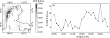
图1
20次降水个例的暴雨中心分布及平均降水量日变化 注:(a)图中圆点面积越大代表降水量级越大。底图采用自然资源部标准地图制作,审图号为GS(2019)1822号,对底图边界无修改。下同。"
表2
降水个例分类"
| 天气系统 | 暴雨时段(北京时) | 持续时间/h | 最大雨量/mm |
|---|---|---|---|
| 副高西北侧型 | 2009年7月7日8:00—8日7:00 | 24 | 汝箕沟107.6 |
| 2012年7月29日20:00—30日11:00 | 16 | 滚钟口174.3 | |
| 2016年8月13日15:00—14日14:00 | 24 | 王老滩110.2 | |
| 2016年8月21日19:00—22日8:00 | 14 | 滑雪场241.7 | |
| 2016年8月22日22:00—23日6:00 | 9 | 路家营子村57 | |
| 2017年7月25日20:00—26日2:00 | 6 | 窑子圈64.4 | |
| 2018年7月22日19:00—23日7:00 | 13 | 滑雪场277.6 | |
| 2018年8月6日12:00—7日16:00 | 29 | 马莲口119.1 | |
| 2018年8月31日19:00—9月1日17:00 | 23 | 苦水沟136.9 | |
| 高空槽前型 | 2015年9月3日4:00—4日1:00 | 21 | 小口子65.9 |
| 2015年9月8日1:00—8日20:00 | 20 | 八顷村69.6 | |
| 2016年7月24日5:00—12:00 | 8 | 灵武煤矿89.5 | |
| 2017年6月4日15:00—5日10:00 | 20 | 黄旗口沟116.5 | |
| 2017年7月5日3:00—18:00 | 16 | 滑雪场114.4 | |
| 2018年7月1日9:00—2日1:00 | 17 | 牛首山84.3 | |
| 2018年7月19日3:00—10:00 | 8 | 明长城136.2 | |
| 2018年7月23日12:00—20:00 | 9 | 红翔新村89.3 | |
| 2018年8月9日12:00—10日13:00 | 26 | 临河镇71.4 | |
| 2019年8月2日18:00—3日0:00 | 7 | 暖泉农场71 | |
| 2020年8月11日7:00—12日8:00 | 26 | 五渠村142.5 |
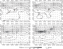
图2
高空槽前型暴雨500 hPa(a:降水前;b:降水后)和200 hPa(c:降水前;d:降水后)的平均风场(风羽,单位:m·s-1)及位势高度场(等值线,单位:dagpm ) 注:黑色粗实线为槽线,G为高压中心,阴影为风速大于30 m·s-1的高空急流区。下同。"

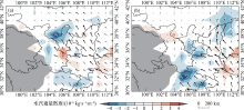
图3
高空槽前型暴雨的850 hPa(a:降水前;b:降水后)平均水汽通量(矢量,单位:kg·s-1·m-1)和水汽通量散度(阴影,单位:10-6 kg·s-1·m-2) 注:灰色阴影为地形大于3000 m的区域。下同。"


图4
副高西北侧型暴雨的500 hPa(a:降水前;b:降水后)和200 hPa(c:降水前;d:降水后)平均风场(风羽,单位:m·s-1)及位势高度场(等值线,单位:dagpm)"

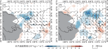
图5
副高西北侧型暴雨的850 hPa(a:降水前;b:降水后)平均水汽通量(矢量,单位:10-6 kg·s-1·m-1)和水汽通量散度(阴影,单位:10-6 kg·s-1·m-2)"

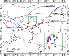
图6
副高西北侧型(红色实线、红色点)和高空槽前型(蓝色实线,蓝色点)降水过程中500 hPa槽脊分布与对应的暴雨中心(右下角小图)示意图 注:图中棕色曲线和棕色箭头分别代表槽线与槽移动方向。"

表3
贺兰山东麓20次暴雨个例的低空急流特征"
| 个例 | 降水中心距山体位置/km | 最大过程 雨量/mm | 最大小时 雨强/mm | 急流强度/(m·s-1) | 急流中心移速 /(km·h-1) | |
|---|---|---|---|---|---|---|
| 副高西北侧型 | 2016-08-21 | 6.1 | 241.7 | 82.5 | 14.492 | 12.0 |
| 2018-07-22 | 11.5 | 277.6 | 74.1 | 17.935 | 17.4 | |
| 2017-07-25 | 15.6 | 64.4 | 57.7 | 16.055 | 10.1 | |
| 2018-08-31 | 24.5 | 136.9 | 65.1 | 15.672 | 27.1 | |
| 2012-07-29 | 25.8 | 174.3 | 47.7 | 11.626 | 29.3 | |
| 2009-07-07 | 9.7 | 107.6 | 39.6 | 14.094 | 23.2 | |
| 2018-08-06 | 28.2 | 119.1 | 52.3 | - | - | |
| 2016-08-22 | 35.0 | 57.3 | 53.7 | 9.756 | 20.7 | |
| 2016-08-13 | 35.8 | 110.2 | 51.7 | 12. 000 | 15.1 | |
| 高空槽前型 | 2018-07-19 | 20.1 | 136.2 | 54.5 | 23.582 | 23.5 |
| 2017-07-05 | 21.7 | 114.4 | 47.4 | 14.200 | 19.9 | |
| 2020-08-11 | 20.7 | 142.5 | 84.5 | 18.112 | 41.9 | |
| 2018-08-09 | 26.1 | 71.4 | 71.4 | - | - | |
| 2015-09-03 | 30.2 | 65.9 | 27.9 | 16.924 | 26.6 | |
| 2017-06-04 | 30.8 | 116.5 | 26.7 | 11.901 | 29.2 | |
| 2019-08-02 | 30.8 | 71 | 53.9 | 14.328 | 34.0 | |
| 2015-09-08 | 34.7 | 69.6 | 50.4 | 13.581 | 26.5 | |
| 2016-07-24 | 37.2 | 89.5 | 56.5 | 13.901 | 19.3 | |
| 2018-07-23 | 41.4 | 89.3 | 58 | 13.625 | 19.5 | |
| 2018-07-01 | 44.3 | 84.3 | 29.8 | 10.892 | 53.8 |

图7
最大小时雨强与急流中心移速(a)和急流中心风速(b)以及最大过程雨量与急流中心风速(c)的统计特征"
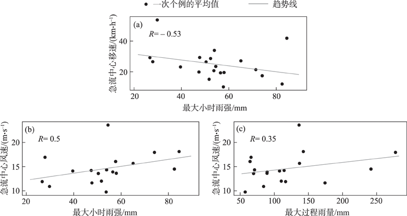
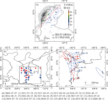
图8
两类降水过程(I:副高西北侧类降水,II:高空槽前类降水)的合成平均降水量(a)与降水过程中低空急流中心位置(b,圆点面积越大表示急流中心风速越大)、活动路径(c)示意图 注:红色和蓝色分别对应副高西北侧型(I)、高空槽前型(II)降水过程,c中箭头末端0~17数字对应图例中的暴雨个例编号。"

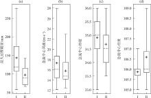
图9
两类降水过程对应的低空急流特征 注:I为副高西北侧型降水;II为高空槽前型降水;虚线代表中位数;“+”号代表平均值。"
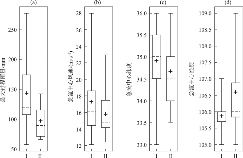

图10
低空急流中心风向频率 注:黑色虚线表示贺兰山山体走向。"
图11
两类降水过程中典型个例的急流移动路径、急流最强时刻(标记为蓝色的时刻)700 hPa流场图及雨强中心站点小时降水量折线图(单位,mm) 注:图中风羽、红色(蓝色)点分别代表此时的急流中心的风速(风速>10 m·s-1)位置,散点图表示此个例降水量分布,红色箭头表示急流中心移动方向,折线图中的编号与流场图中时刻相对应。"

| [1] |
刘燕飞, 隆霄, 王晖. 陕西中西部地区一次暴雨过程的数值模拟研究[J]. 高原气象, 2015, 34(2): 378-388.
doi: 10.7522/j.issn.1000-0534.2013.00182 |
|
[ Liu Yanfei, Long Xiao, Wang Hui. Numerical simulation studies on a rainstorm in central western Shaanxi Province[J]. Plateau Meteorology, 2015, 34(2): 378-388. ]
doi: 10.7522/j.issn.1000-0534.2013.00182 |
|
| [2] |
庄晓翠, 李博渊, 秦榕, 等. 新疆东部一次区域极端暴雨环境场特征[J]. 高原气象, 2020, 39(5): 947-959.
doi: 10.7522/j.issn.1000-0534.2019.00081 |
|
[ Zhuang Xiaocui, Li Boyuan, Qin Rong, et al. Analysis on the causes of an extreme rainstorm in the eastern Xinjiang[J]. Plateau Meteorology, 2020, 39(5): 947-959. ]
doi: 10.7522/j.issn.1000-0534.2019.00081 |
|
| [3] | 冯建民, 胡文东, 陈楠, 等. 宁夏天气预报手册[M]. 北京: 气象出版社, 2012: 12-14. |
| [ Feng Jianmin, Hu Wendong, Chen Nan, et al. Ningxia Weather Forecast Manual[M]. Beijing: China Meteorological Press, 2012: 12-14. ] | |
| [4] | 李江萍, 李俭峰, 杜亮亮. 近50年夏季西北暴雨特征和水汽轨迹分析[J]. 兰州大学学报(自然科学版), 2013, 49(4): 474-482. |
| [ Li Jiangping, Li Jianfeng, Du Liangliang. General situation of heavy rain in Northwest China and analysis of a case[J]. Journal of Lanzhou University (Natural Sciences Edition), 2013, 49(4): 474-482. ] | |
| [5] | 陈豫英, 陈楠, 任小芳, 等. 贺兰山东麓罕见特大暴雨的预报偏差和可预报性分析[J]. 气象, 2018, 44(1): 159-169. |
| [ Chen Yuying, Chen Nan, Ren Xiaofang, et al. Analysis on forecast deviation and predictability of a rare severe rainstorm along the eastern Helan Mountain[J]. Meteorological Monthly, 2018, 44(1): 159-169. ] | |
| [6] | 陶林科, 杨侃, 胡文东, 等. “7·30”大暴雨的数值模拟及贺兰山地形影响分析[J]. 沙漠与绿洲气象, 2014, 8(4): 32-39. |
| [ Tao Linke, Yang Kan, Hu Wendong, et al. The contribution of Helan Mountain to the formation of a heavy rainstorm occurred over Yinchuan Plain by numerical simulation[J]. Desert and Oasis Meteorology, 2014, 8(4): 32-39. ] | |
| [7] | 陈晓娟, 王咏青, 毛璐, 等. 贺兰山区两次极端暴雨动力作用数值模拟分析[J]. 干旱区研究, 2020, 37(3): 680-688. |
| [ Chen Xiaojuan, Wang Yongqing, Mao Lu, et al. Numerical simulation analysis of the dynamic effects of terrain on two extreme rainstorms on Helan Mountain[J]. Arid Zone Research, 2020, 37(3): 680-688. ] | |
| [8] | 纪晓玲, 冯建民, 穆建华, 等. 宁夏北部一次短时暴雨中尺度对流系统的特征分析[J]. 大气科学学报, 2010, 33(6): 711-718. |
| [ Ji Xiaoling, Feng Jianmin, Mu Jianhua, et al. Analysis on characteristics of mesoscale convective system during a short-term rainstorm processin North of Ningxia[J]. Transactions of Atmospheric Sciences, 2010, 33(6): 711-718. ] | |
| [9] |
陈豫英, 苏洋, 杨银, 等. 贺兰山东麓极端暴雨的中尺度特征[J]. 高原气象, 2021, 40(1): 47-60.
doi: 10.7522/j.issn.1000-0534.2020.00012 |
|
[ Chen Yuying, Su Yang, Yang Yin, et al. The mesoscale characteristics of extreme rainstorm in the eastern region of Helan Mountain[J]. Plateau Meteorology, 2021, 40(1): 47-60. ]
doi: 10.7522/j.issn.1000-0534.2020.00012 |
|
| [10] |
胡文东, 杨侃, 黄小玉, 等. 一次阵风锋触发强对流过程雷达资料特征分析[J]. 高原气象, 2015, 34(5): 1452-1464.
doi: 10.7522/j.issn.1000-0534.2014.00099 |
|
[ Hu Wendong, Yang Kai, Huang Xiaoyu, et al. Analysis on a severe convection triggered by gust front in Yinchuan with radar data[J]. Plateau Meteorology, 2015, 34(5): 1452-1464. ]
doi: 10.7522/j.issn.1000-0534.2014.00099 |
|
| [11] |
Bonner W D. Climatology of the low level jet[J]. Monthly Weather Review, 1968, 96(12): 833-850.
doi: 10.1175/1520-0493(1968)096<0833:COTLLJ>2.0.CO;2 |
| [12] | 许美玲, 段旭, 孙绩华, 等. 与低空急流相伴的暴雨天气诊断分析[J]. 云南大学学报(自然科学版), 2004, 26(4): 320-324. |
| [ Xu Meiling, Duan Xu, Sun Jihua, et al. Diagnostic study on the torrential rains coupling with the lower southwest jets in Yunnan[J]. Journal of Yunnan University(Natural Sciences Edition), 2004, 26(4): 320-324. ] | |
| [13] | 张云, 雷恒池, 钱贞成. 一次东北冷涡衰退阶段暴雨成因分析[J]. 大气科学, 2008, 32(3): 481-498. |
| [ Zhang Yun, Lei Hengchi, Qian Zhencheng. Analyses of formation mechanisms of a rainstorm during the declining phase of a northeast cold vortex[J]. Chinese Journal of Atmospheric Sciences, 2008, 32(3): 481-498. ] | |
| [14] | 赛瀚, 苗峻峰. 中国地区低空急流研究进展[J]. 气象科技, 2012, 40(5): 766-771. |
| [ Han Han, Miao Junfeng. A review of low-level jet research in China[J]. Meteorological Science and Technology, 2012, 40(5): 766-771. ] | |
| [15] | 周静, 郑永骏, 苗春生, 等. 梅雨锋强降水与低空急流日变化的观测分析和数值模拟[J]. 热带气象学报, 2017, 33(5): 750-761. |
| [ Zhou Jing, Zheng Yongjun, Miao Chunsheng, et al. The characteristics and numerical simulation of diurnal variations of low-level jet and Meiyu front heavy rainfall[J]. Journal of Tropical Meteorology, 2017, 33(5): 750-761. ] | |
| [16] | 陈玉春, 钱正安. 夏季青藏高原地形对其东侧低空急流动力影响的数值模拟[J]. 高原气象, 1993, 12(3): 312-321. |
| [ Chen Yuchun, Qian Zhengan. Numerical simulations of dynamical impact of Qinghai-Xizang plateau on lower-level jet on its east side in summer[J]. Plateau Meteorology, 1993, 12(3): 312-321. ] | |
| [17] | 陈贵川, 沈桐立, 何迪. 江南丘陵和云贵高原地形对一次西南涡暴雨影响的数值试验[J]. 高原气象, 2006, 25(2): 277-284. |
| [ Chen Guichuan, Shen Tongli, He Di. Simulation of topographic effect of hilly region to the south of yangtze river and Yunnan-Guizhou Plateau on the Southwest vortex during a heavy rain process[J]. Plateau Meteorology, 2006, 25(2): 277-284. ] | |
| [18] |
Blackadar A K. Boundary layer wind maxima and their significance for the growth of nocturnal inversions[J]. Bulletin of the American Meteorological Society, 1957, 38(5): 283-290.
doi: 10.1175/1520-0477-38.5.283 |
| [19] |
Du Y, Rotunno R. A simple analytical model of the nocturnal low-level jet over the great plains of the United States[J]. Journal of Atmospheric Sciences, 2014, 71(10): 3674-3683.
doi: 10.1175/JAS-D-14-0060.1 |
| [20] | 陶诗言. 中国之暴雨[M]. 北京: 科学出版社, 1980: 225. |
| [ Tao Shiyan. Torrential Rain in China[M]. Beijing: Science Press, 1980: 225. ] | |
| [21] | 朱乾根, 林锦瑞, 寿邵文, 等. 天气学原理和方法[M]. 北京: 科学出版社, 2007: 485-492. |
| [ Zhu Qiangen, Lin Jinrui, Shou Shaowen, et al. Synoptic Principles and Methods[M]. Beijing: Science Press, 2007: 485-492. ] | |
| [22] | 孙颖姝. 低空急流与新疆强降水的关系[D]. 南京: 南京信息工程大学, 2019. |
| [ Sun Yingshu. The Relationship between Low-level Jet and Heavy Precipitation in Xinjiang[D]. Nanjing: Nanjing University of Information Science and Technology, 2019. ] | |
| [23] | 李佳. 初夏华南低空急流及其日变化对华南降水的影响[D]. 南京: 南京信息工程大学, 2021. |
| [ Li Jia. Effect of Low-level Jet over South China and Diurnal Variation on Precipitation in South China in Early Summer[D]. Nanjing: Nanjing University of Information Science and Technology, 2021. ] | |
| [24] | 黄嘉佑. 气象统计分析与预报方法[M]. 北京: 气象出版社, 1990: 46-130. |
| [ Huang Jiayou. Meteorological Statistical Analysis and Forecasting Methods[M]. Beijing: China Meteorological Press, 1990: 46-130. ] | |
| [25] | 倪丽霞, 王建英, 陶林科, 等. 加密自动站资料在吴忠强对流天气预报中的应用[J]. 宁夏工程技术, 2014, 13(2): 102-107. |
| [ Ni Lixia, Wang Jianying, Tao Linke, et al. Application of automatic data encryption station in Wuzhong strong convective weather forecast[J]. Ningxia Engineering Technology, 2014, 13(2): 102-107. ] | |
| [26] |
邵建, 裴晓蓉, 刘娟, 等. 近53 a宁夏暴雨时空分布特征[J]. 干旱气象, 2015, 33(4): 595-601.
doi: 10.11755/j.issn.1006-7639(2015)-04-0595 |
|
[ Shao Jian, Pei Xiaorong, Liu Juan, et al. Temporal and spatial distribution characteristics of rainstorms in Ningxia during 1961-2013[J]. Arid Meteorology, 2015, 33(4): 595-601. ]
doi: 10.11755/j.issn.1006-7639(2015)-04-0595 |
|
| [27] | 《西北暴雨》编写组. 西北暴雨[M]. 北京: 气象出版社, 1992. |
| [ Editorial Group of ‘Northwest Rainstorm’. Northwest Rainstorm[M]. Beijing: China Meteorological Press, 1992. ] | |
| [28] | 黄玉霞, 王宝鉴, 黄武斌, 等. 我国西北暴雨的研究进展[J]. 暴雨灾害, 2019, 38(5): 11. |
| [ Huang Yuxia, Wang Baojian, Huang Wubin, et al. A review on rainstorm research in Northwest China[J]. Torrential Rain and Disasters, 2019, 38(5): 11. ] | |
| [29] |
Wang D Q, Zhang Y C, Huang A N. Climatic features of the south-westerly low-level jet over Southeast China and its association with precipitation over East China[J]. Asia-pacific Journal of Atmospheric Sciences, 2003, 49(3): 259-270.
doi: 10.1007/s13143-013-0025-y |
| [30] | 丁一汇. 高等天气学[M]. 北京: 气象出版社, 2005: 309-523. |
| [ Ding Yihui. Advanced Synoptic Science[M]. Beijing: China Meteorological Press, 2005: 309-523. ] | |
| [31] | 王遂缠, 胡向军, 张新荣, 等. 雷达资料同化在甘肃局地暴雨天气个例中的应用[J]. 高原气象, 2011, 30(3): 711-718. |
| [ Wang Suichan, Hu Xiangjun, Zhang Xinrong, et al. Application of doppler radar data assimilation in a local rainstorm case in Gansu province[J]. Plateau Meteorology, 2011, 30(3): 711-718. ] | |
| [32] |
孔祥伟, 杨建才, 李红, 等. 甘肃河东地区不同环流形势下短时强降水的雷达回波特征分析[J]. 高原气象, 2021, 40(5): 1057-1070.
doi: 10.7522/j.issn.1000-0534.2020.00084 |
|
[ Kong Xiangwei, Yang Jiancai, Li Hong, et al. Analysis of radar echo characteristics of short-term heavy precipitation weather with different circulation pattern in East Gansu Province[J]. Plateau Meteorology, 2021, 40(5): 1057-1070.]
doi: 10.7522/j.issn.1000-0534.2020.00084 |
|
| [33] | 李巧, 戚友存, 朱自伟, 等. 复杂地形下C波段雷达定量降水估计算法[J]. 气象学报, 2021, 79(4): 689-702. |
| [ Li Qiao, Qi Youcun, Zhu Ziwei, et al. Quantitative precipitation estimation algorithm for C-band radar situated in complex topographical regions[J]. Acta Meteorologica Sinica, 2021, 79(4): 689-702. ] | |
| [34] | 韩文宇, 杨丽丽, 杨毅. C波段雷达资料在强降水过程中的应用[J]. 干旱气象, 2016, 34(1): 154-162. |
| [ Han Wenyu, Yang Lili, Yang Yi. Application of C-band weather radar data in heavy precipitation process[J]. Journal of Arid Meteorology, 2016, 34(1): 154-162. ] |
| [1] | 赵玉娟, 路亚奇, 张洪芬, 张可心, 周忠文, 刘英. 基于模糊数学的甘肃河东地区短时暴雨的大气环境参数综合评价研究[J]. 干旱区研究, 2023, 40(4): 543-551. |
| [2] | 曹怡清,隆霄,李超,王思懿,赵建华. 低空急流对贺兰山东麓两次暴雨影响的数值模拟研究[J]. 干旱区研究, 2022, 39(6): 1739-1752. |
| [3] | 黄晓璐,李瑞青,李林惠,林弘杰,姚乐宝. 内蒙古河套地区一次对流暴雨的中尺度对流系统演变特征[J]. 干旱区研究, 2022, 39(6): 1728-1738. |
| [4] | 张君霞,孔祥伟,刘新伟,王勇. 青藏高原东北侧暴雨数值模式预报空间误差特征[J]. 干旱区研究, 2022, 39(1): 64-74. |
| [5] | 杨霞,周鸿奎,赵克明,许婷婷. 塔里木东风低空急流特征分析[J]. 干旱区研究, 2021, 38(5): 1216-1225. |
| [6] | 刘义花,李红梅,温婷婷,申红艳,韩忠全,朱宝文. 柴达木盆地夏季暴雨灾害风险区划及其影响[J]. 干旱区研究, 2021, 38(3): 757-763. |
| [7] | 杨霞,周鸿奎,许婷婷,华烨. 南疆夏季不同类型暴雨精细化特征对比分析[J]. 干旱区研究, 2021, 38(3): 747-756. |
| [8] | 丁明月, 王俐俐, 辛 渝, 刘 琼, 陈勇航, 张广兴, 杨莲梅, 梁 倩, 黄 观, 刘统强. 基于CloudSat卫星资料对中亚低涡暴雨个例的诊断分析和数值模拟[J]. 干旱区研究, 2020, 37(4): 936-946. |
| [9] | 丁明月, 王俐俐, 辛渝, 陈勇航, 杨莲梅, 梁倩, 刘琼, 刘统强. WRF云微物理参数化方案对新疆暴雨模拟能力的TS评分分析[J]. 干旱区研究, 2019, 36(6): 1411-1418. |
| [10] | 蒋雨荷,王式功1、靳双龙2、樊晋1. 中国北方一次强沙尘暴天气过程的大气污染效应[J]. 干旱区研究, 2018, 35(6): 1344-1351. |
| [11] | 王伏村,许东蓓,张德玉,代德彬,韩树浦, 修韶宇. 西北地区东部一次大暴雨天气过程的诊断分析[J]. 干旱区研究, 2014, 31(3): 452-462. |
| [12] | 韩军彩, 王传辉, 陈静, 阎访, 杨鹏, 王磊. 石家庄市暴雨变化特征及降水极值重现期研究[J]. 干旱区研究, 2013, 30(5): 796-801. |
| [13] | 杨晓玲, 丁文魁, 钱沛泉, 殷玉春, 姚玉璧. 2012年7月29日武威市大到暴雨天气过程分析[J]. 干旱区研究, 2013, 30(5): 789-795. |
| [14] | 王伏村, 吴晓京, 付双喜, 张德玉 , 田雨. 敦煌地区“6•16”暴雨的热力和动力特征[J]. 干旱区研究, 2013, 30(1): 56-66. |
| [15] | 孔祥伟, 陶健红. 近51 a甘肃夏季气温和降水极端事件变化[J]. 干旱区研究, 2012, 29(6): 965-971. |
|
||