干旱区研究 ›› 2023, Vol. 40 ›› Issue (3): 481-491.doi: 10.13866/j.azr.2023.03.14 cstr: 32277.14.AZR.20230314
崔帅( ),许强(),袁爽,蒲川豪,陈婉琳,纪续
收稿日期:2022-08-02
修回日期:2022-10-01
出版日期:2023-03-15
发布日期:2023-03-31
作者简介:崔帅(1999-),男,硕士研究生,研究方向为地质灾害. E-mail: 基金资助:
CUI Shuai(),XU Qiang(),YUAN Shuang,PU Chuanhao,CHEN Wanlin,JI Xu
Received:2022-08-02
Revised:2022-10-01
Published:2023-03-15
Online:2023-03-31
摘要:
黄土沟谷的发育演化进程研究对于发掘沟谷形成与土壤侵蚀的内在机理,指导黄土地区生态修复有深刻的指导意义。基于沟谷水平空间、气候、沟谷点线面特征选取10个沟谷发育程度量化指标,利用组合熵权RSR法优异的多因子综合性分档评价能力建立董志塬沟谷发育阶段分级评价模型,探究黄土沟谷的发育演化及分布规律。研究发现:(1) 基于熵权法计算归一化植被指数(NDVI)所占权重最高为16.08%,其次为沟谷密度(15.621%),两者是判断沟谷发育程度的重要指标。(2) 基于组合熵权RSR法将董志塬82条沟谷发育程度分为幼年期、青年期、壮年期和老年期,壮年期和老年期沟谷面积占比为88.48%,董志塬东部及北部发育程度较高,对于塬面侵蚀强烈。(3) 沟谷发育程度与其下伏古地貌、构造地质和黄土厚度有着高度相关性。(4) 模型方差一致性检验显著性水平P<0.001,线性回归拟合优度R2为0.986,评价模型表现良好。
崔帅, 许强, 袁爽, 蒲川豪, 陈婉琳, 纪续. 基于组合熵权RSR法的董志塬沟谷发育评价[J]. 干旱区研究, 2023, 40(3): 481-491.
CUI Shuai, XU Qiang, YUAN Shuang, PU Chuanhao, CHEN Wanlin, JI Xu. Evaluation of Dongzhi Loess Plateau Gully development based on combined entropy weight Rank-Sum Ratio method[J]. Arid Zone Research, 2023, 40(3): 481-491.

图1
研究区地理位置"

表1
沟谷发育评价正向指标"
| 指标名称 | 计算公式 | 解释 | 指标意义 |
|---|---|---|---|
| 边界维数 | M为沟谷面积;N为沟谷沿线周长;C为沟谷周长 | 反映水平方向上沟谷空间展布的复杂程度和沟谷的发育程度。指标值越大,说明局部沟谷与整体沟谷网络的相似程度越高,沟谷形态结构越复杂,发育程度越高。 | |
| 沟谷密度 | 反映沟头前进及沟谷侵蚀发育程度的重要指标。指标值越大,说明沟头前进程度越大,即沟谷生长延伸程度越大,发育程度越高。 | ||
| 地表切割深度 | 直观反映了沟谷下切发育程度和地表被侵蚀切割的程度。指标值越大,地表侵蚀切割越剧烈,沟谷下切发育程度越高。 | ||
| 平均坡度 | 在一定程度上反映沟谷地貌的发育程度。沟谷发育初期,沟谷发育以下切为主,指标值逐渐增大,随着沟谷发育程度的增加,沟谷在深切的同时也在横向展宽,指标值反而有所下降。 | ||
| 月平均降雨 | 气候影响因素之一,降雨的多少一定程度上影响水流侵蚀的剧烈程度。 |
表2
沟谷发育评价负向指标"
| 指标名称 | 计算公式 | 解释 | 指标意义 |
|---|---|---|---|
| 主沟支沟比 | R为主沟支沟比; | 从沟谷长度的角度反映沟谷系统中支沟的发育程度。指标值越小,沟谷系统中支沟发育越明显,说明沟谷系统整体发育程度越高。 | |
| 土地利用程度综合指标 | 是针对一个具体年份内所有土地利用类型整体反映的土地利用集约化程度。通过对土地利用程度的分级,量化人类活动对于土地系统的影响程度,定量地描述该地区土地利用的综合水平和变化趋势,是衡量指定区域内土地利用情况的一个重要指标。 | ||
| 主沟纵比降 | 反映沟谷整体侵蚀势能,是描述沟谷在垂直方向上侵蚀发育程度的重要指标。指标值越小,说明沟谷的侵蚀能量越低,沟谷越趋近于稳定的宽谷,发育程度越高。 | ||
| 归一化植被指数 | NIR为近红外波段的反射值;R为红光波段的反射值 | 反映土地覆盖植被状况的一种遥感指标,定义为近红外通道与可见光通道反射率之差与之和的商。 | |
| 圆度率 | 反应水平方向上沟谷接近圆的程度,其值越接近1,则越接近圆,其发育程度越低。 |
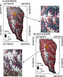
图2
董志塬沟谷原始数据解译"


图3
沟谷发育正向指标赋值"

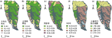
图4
沟谷发育负向指标赋值"


图5
沟谷发育程度评价指标权重"

表3
董志塬沟谷发育阶段分级"
| 发育阶段 | 百分位临界值 | Probit | 秩和比临界值(拟合值) | 频数 | 面积/km2 | 面积占比 |
|---|---|---|---|---|---|---|
| 幼年期 | <6.681 | <3.5 | <0.3106 | 5 | 10.04 | 0.63% |
| 青年期 | 6.681~50 | 3.5~5 | 0.3106~0.4692 | 36 | 177.61 | 10.89% |
| 壮年期 | 50~93.319 | 5~6.5 | 0.4692~0.6277 | 35 | 799.58 | 49.06% |
| 老年期 | >93.319 | >6.5 | >0.6277 | 6 | 642.44 | 39.42% |

图6
董志塬沟谷发育程度分异"

表4
方差一致性检验及线性回归分析"
| 非标准化系数 | 标准化系数 | t | P | VIF | R2 | 调整R2 | F | ||
|---|---|---|---|---|---|---|---|---|---|
| B | 标准误 | Beta | |||||||
| 常数 | -0.059 | 0.007 | - | -8.173 | 0.001 | - | 0.986 | 0.986 | 5567.72 |
| Probit | 0.106 | 0.001 | 0.993 | 74.617 | 0.001 | 1 | |||
表5
林龄与根系提高土的抗剪强度的关系"
| 林龄/a | 6~10 | 10~19 | 20~29 | 30~40 | >40 |
|---|---|---|---|---|---|
| 提高土的抗剪强度/kPa | 0.04 | 0.08 | 0.13 | 0.15 | 0.18 |

图7
沟谷密度与输沙模数关系"


图8
董志塬沟谷地质构造"


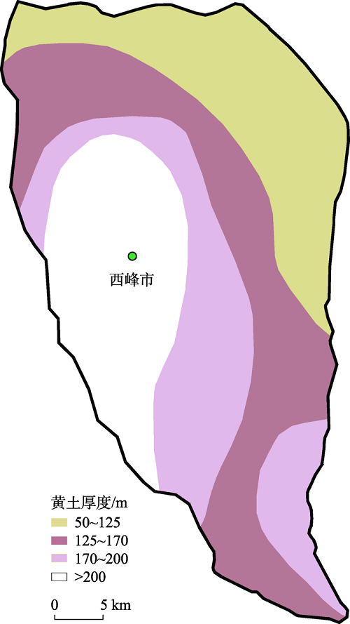
图9
董志塬沟谷黄土厚度"
| [1] |
熊礼阳, 汤国安. 黄土高原沟谷地貌发育演化研究进展与展望[J]. 地球信息科学学报, 2020, 22(4): 816-826.
doi: 10.12082/dqxxkx.2020.190519 |
|
[Xiong Liyang, Tang Guo’an. Research progresses and prospects of gully landform formation and evolution in the Loess Plateau of China[J]. Journal of Geo-information Science, 2020, 22(4): 816-826.]
doi: 10.12082/dqxxkx.2020.190519 |
|
| [2] |
罗来兴. 划分晋西、 陕北、 陇东黄土区域沟间地与沟谷的地貌类型[J]. 地理学报, 1956, 22(3): 201-222.
doi: 10.11821/xb195603002 |
|
[Luo Laixing. A tentative classification of landforms in the Loess Plateau[J]. Acta Geographica Sinica, 1956, 22(3): 201-222.]
doi: 10.11821/xb195603002 |
|
| [3] | 黄秉维. 编制黄河中游流域土壤侵蚀分区图的经验教训[J]. 科学通报, 1955, 6(12): 15-21, 14. |
| [Huang Bingwei. Lessons learned from the preparation of soil erosion zoning maps in the middle reaches of the Yellow River basin[J]. Chinese Science Bulletin, 1955, 6(12): 15-21, 14.] | |
| [4] |
袁宝印, 巴特尔, 崔久旭, 等. 黄土区沟谷发育与气候变化的关系(以洛川黄土塬区为例)[J]. 地理学报, 1987, 42(4): 328-337.
doi: 10.11821/xb198704005 |
|
[Yuan Baoyin, Bartel, Cui Jiuxu, et al. The relationship between gully development and climatic changes in the Loess Yuan Region: Examples from Luochuan, Shanxi Province[J]. Acta Geographica Sinica, 1987, 42(4): 328-337.]
doi: 10.11821/xb198704005 |
|
| [5] | 胡刚, 伍永秋. 发生沟蚀(切沟)的地貌临界研究综述[J]. 山地学报, 2005, 23(5): 55-60. |
| [Hu Gang, Wu Yongqiu. Progress in the study of geomorphic threshold theory in channel (gully) Erosion[J]. Mountain Research, 2005, 23(5): 55-60.] | |
| [6] |
邓成龙, 袁宝印. 末次间冰期以来黄河中游黄土高原沟谷侵蚀-堆积过程初探[J]. 地理学报, 2001, 56(1): 92-98.
doi: 10.11821/xb200101011 |
|
[Deng Chenglong, Yuan Baoyin. Processes of gully erosion and accumulation in the central Loess Plateau of China since the last interglacial[J]. Acta Geographica Sinica, 2001, 56(1): 92-98.]
doi: 10.11821/xb200101011 |
|
| [7] | 黄骁力. 基于DEM的黄土沟谷地貌演化空代时研究[D]. 南京: 南京师范大学, 2019. |
| [Huang Xiaoli. Space-for-time Substitution and Gully Evolution in the Chinese Loess Plateau[D]. Nanjing: Nanjing Normal University, 2019.] | |
| [8] | 王崔林. 黄土董志塬沟谷侵蚀发育空间分异特征及其综合治理模式研究[D]. 成都: 成都理工大学, 2020. |
| [Wang Cuilin. Study on the Gully Spatial Differentiation Characteristics and Comprehensive Control Mode of Dongzhiyuan Area in the Loess Plateau[D]. Chengdu: Chengdu University of Technology, 2020.] | |
| [9] |
周毅, 王泽涛, 杨锋. 基于DEM的黄土沟谷横剖面形态特征研究——以宜君、 延安、 绥德为例[J]. 地理科学, 2020, 40(3): 455-465.
doi: 10.13249/j.cnki.sgs.2020.03.014 |
|
[Zhou Yi, Wang Zetao, Yang Feng. Morphological characteristics of gully cross-section in the Loess Region based DEM: Taking Yijun, Yan’an and Suide as cases[J]. Scientia Geographica Sinica, 2020, 40(3): 455-465.]
doi: 10.13249/j.cnki.sgs.2020.03.014 |
|
| [10] | 李晨瑞. 基于地形特征要素的黄土沟谷发育及区域差异性研究[D]. 南京: 南京师范大学, 2018. |
| [Li Chenrui. Studies on Gully Development and Regional Difference in Loess Plateau Based on Topographic Feature Elements[D]. Nanjing: Nanjing Normal University, 2018.] | |
| [11] | 景可. 黄土高原沟谷侵蚀研究[J]. 地理科学, 1986, 6(4): 340-347. |
| [Jing Ke. A study on erosion on the Loess Plateau[J]. Scientia Geographica Sinica, 1986, 6(4): 340-347.] | |
| [12] | 何雨, 贾铁飞, 李容全. 黄土丘陵区沟谷发育及其稳定性评价[J]. 干旱区地理, 1999, 22(2): 64-70. |
| [He Yu, Jia Tiefei, Li Rongquan. Development of gullies and evaluation on their stability in Loess Hill Region[J]. Arid Land Geography, 1999, 22(2): 64-70.] | |
| [13] |
陈传康. 陇东东南部黄土地形类型及其发育规律[J]. 地理学报, 1956, 22(3): 223-231.
doi: 10.11821/xb195603003 |
|
[Chen Chuankang. Topographic types of loess in southeastern Longdong and their development pattern[J]. Acta Geographica Sinica, 1956, 22(3): 223-231.]
doi: 10.11821/xb195603003 |
|
| [14] | 严宝文, 王涛, 马耀光. 黄土高原水蚀沟谷发育阶段研究[J]. 人民黄河, 2004, 26(6): 16-18. |
| [Yan Baowen, Wang Tao, Ma Yaoguang. Study on the development stages of water erosion gullies in Loess Plateau[J]. Yellow River, 2004, 26(6): 16-18.] | |
| [15] | 袁爽, 许强, 赵宽耀, 等. 基于统计学的陇东地区沟谷分布及演化研究[J]. 水土保持通报, 2020, 40(5): 172-180. |
| [Yuan Shuang, Xu Qiang, Zhao Kuanyao, et al. Gully distribution and evolution in East Gansu Province based on statistics[J]. Bulletin of Soil and Water Conservation, 2020, 40(5): 172-180.] | |
| [16] |
Li C, Li F, Dai Z, et al. Spatial variation of gully development in the loess plateau of China based on the morphological perspective[J]. Earth Science Informatics, 2020, 13(4): 1103-1117.
doi: 10.1007/s12145-020-00491-4 |
| [17] |
Wang R, Sun H, Yang J, et al. Quantitative evaluation of gully erosion using multitemporal UAV data in the southern black soil region of Northeast China: A case study[J]. Remote Sensing, 2022, 14(6): 1479.
doi: 10.3390/rs14061479 |
| [18] | Wang T, He F, Zhang A, et al. A quantitative study of gully erosion based on object-oriented analysis techniques: A case study in Beiyanzikou catchment of Qixia, Shandong, China[J]. The Scientific World Journal, 2014, 15(2): 1-11. |
| [19] |
Thwaites R N, Brooks A P, Pietsch T J, et al. What type of gully is that? The need for a classification of gullies[J]. Earth Surface Processes and Landforms, 2022, 47(1): 109-128.
doi: 10.1002/esp.v47.1 |
| [20] |
Liu D, Liang X, Chen H, et al. A quantitative assessment of comprehensive ecological risk for a loess erosion gully: A case study of Dujiashi Gully, Northern Shaanxi Province, China[J]. Sustainability, 2018, 10(9): 3239.
doi: 10.3390/su10093239 |
| [21] | 孙利娟, 邢小军, 周德群. 熵值赋权法的改进[J]. 统计与决策, 2010, 26(21): 153-154. |
| [Sun Lijuan, Xing Xiaojun, Zhou Dequn. Improvement of entropy assignment method[J]. Statistics & Decision, 2010, 26(21): 153-154.] | |
| [22] | 刘晓华, 许启发. 方差分析与虚拟变量回归模型的比较研究[J]. 统计与决策, 2012, 28(7): 34-38. |
| [Liu Xiaohua, Xu Qifa. A comparative study of analysis of variance and dummy variable regression models[J]. Statistics & Decision, 2012, 28(7): 34-38.] | |
| [23] | 杜家菊, 陈志伟. 使用SPSS线性回归实现通径分析的方法[J]. 生物学通报, 2010, 45(2): 4-6. |
| [Du Jiaju, Chen Zhiwei. A method for implementing throughput analysis using SPSS linear regression[J]. Bulletin of Biology, 2010, 45(2): 4-6.] | |
| [24] |
刘畅, 周毅, 雷雪. 陕北黄土高原水蚀沟谷多维度侵蚀特征量化研究[J]. 地理科学进展, 2022, 41(4): 707-717.
doi: 10.18306/dlkxjz.2022.04.014 |
|
[Liu Chang, Zhou Yi, Lei Xue. Quantitative analysis of multi-dimensional erosion characterstics of waterworn gullies on the Loess Plateau of Northern Shaanxi[J]. Progress in Geography, 2022, 41(4): 707-717.]
doi: 10.18306/dlkxjz.2022.04.014 |
|
| [25] | 赵卫东, 周文怡, 马雷, 等. 基于势能信息熵的黄土小流域沟谷网络演化特征研究[J]. 地理与地理信息科学, 2021, 37(6): 1-6. |
| [Zhao Weidong, Zhou Wenyi, Ma Lei, et al. Study on evolution characteristic of valley network in small loess watershed based on potential energy information entropy[J]. Geography and Geo-Information Science, 2021, 37(6): 1-6.] | |
| [26] | 刘洋, 李春阳. 植被因子对水土流失的影响[J]. 世界科技研究与发展, 2005, 27(5): 95-99. |
| [Liu Yang, Li Chunyang. The impact of plant factor on water and soil erosion[J]. World Sci-Tech R & D, 2005, 27(5): 95-99.] | |
| [27] | 杜峰, 程积民. 植被与水土流失[J]. 四川草原, 1999, 20(2): 7-12. |
| [Du Feng, Cheng Jimin. Loss of water, erosion of soil and vegetation[J]. Journal of Grassland and Forage Science, 1999, 20(2): 7-12.] | |
| [28] | 解明曙. 林木根系固坡土力学机制研究[J]. 水土保持学报, 1990, 4(3): 7-14, 50. |
| [Xie Mingshu. A study on the soil mechanical role of tree roots in the stability of slopes[J]. Journal of Soil and Water Conservation, 1990, 4(3): 7-14, 50.] | |
| [29] |
Jiao J, Zou H, Jia Y, et al. Research progress on the effects of soil erosion on vegetation[J]. Acta Ecologica Sinica, 2009, 29(2): 85-91.
doi: 10.1016/j.chnaes.2009.05.001 |
| [30] | 杨丹, 王晓峰. 黄土高原气候和人类活动对植被NPP变化的影响[J]. 干旱区研究, 2022, 39(2): 584-593. |
| [Yang Dan, Wang Xiaofeng. Contribution of climatic change and human activities to changes in net primary productivity in the Loess Plateau[J]. Arid Zone Research, 2022, 39(2): 584-593.] | |
| [31] |
Renison D, Hensen I, Cingolani A M. Anthropogenic soil degradation affects seed viability in Polylepis australis mountain forests of central Argentina[J]. Forest Ecology and Management, 2004, 196(2-3): 327-333.
doi: 10.1016/j.foreco.2004.03.025 |
| [32] |
Zhou Z C, Shangguan Z P, Zhao D. Modeling vegetation coverage and soil erosion in the Loess Plateau Area of China[J]. Ecological Modelling, 2006, 198(1-2): 263-268.
doi: 10.1016/j.ecolmodel.2006.04.019 |
| [33] |
Zhao J, Vanmaercke M, Chen L, et al. Vegetation cover and topography rather than human disturbance control gully density and sediment production on the Chinese Loess Plateau[J]. Geomorphology, 2016, 274: 92-105.
doi: 10.1016/j.geomorph.2016.09.022 |
| [34] |
田剑, 汤国安, 周毅, 等. 黄土高原沟谷密度空间分异特征研究[J]. 地理科学, 2013, 33(5): 622-628.
doi: 10.13249/j.cnki.sgs.2013.05.622 |
|
[Tian Jian, Tang Guo’an, Zhou Yi, et al. Spatial variation of gully density in the Loess Plateau[J]. Scientia Geographica Sinica, 2013, 33(5): 622-628.]
doi: 10.13249/j.cnki.sgs.2013.05.622 |
|
| [35] | 姚文波. 历史时期董志塬地貌演变过程及其成因[D]. 西安: 陕西师范大学, 2009. |
| [Yao Wenbo. The Evolution Process of Dongzhi Loess Plateau Landform and Its Causes During the Historical Period[D]. Xi’an: Shaanxi Normal University, 2009.] | |
| [36] | 熊礼阳. 基于DEM的黄土地貌继承性研究[D]. 南京: 南京师范大学, 2015. |
| [Xiong Liyang. DEM based Research on the Loess Landform Inheritance in the Loess Plateau of China[D]. Nanjing: Nanjing Normal University, 2015.] | |
| [37] | 袁爽, 许强, 赵宽耀, 等. 陇东地区残塬分布规律及影响因素分析[J]. 人民长江, 2019, 50(8): 63-69, 108. |
| [Yuan Shuang, Xu Qiang, Zhao Kuanyao, et al. Analysis on distribution law and influencing factors of residual tableland in east Gansu Province[J]. Yangtze River, 2019, 50(8): 63-69, 108.] | |
| [38] | Shahab H, Emami H, Haghnia G H. Effects of gully erosion on soil quality indices in northwestern Iran[J]. Journal of Agricultural Science and Technology, 2018, 20(6): 1317-1329. |
| [39] | 姜琳, 王清晨, 王香增, 等. 鄂尔多斯盆地东南部中生界地层节理发育特征与古应力场[J]. 岩石学报, 2013, 29(5): 1774-1790. |
| [Jiang Lin, Wang Qingchen, Wang Xiangzeng, et al. Joint development and paleostress field in Mesozoic strata of the southeastern Ordos Basin.[J]. Acta Petrologica Sinica, 2013, 29(5): 1774-1790.] |
| [1] | 邱春霞, 刘晓宏, 李豆, 张佳淼, 李朋飞. 机载LiDAR和模糊推理系统在黄土高原土壤侵蚀监测中的应用[J]. 干旱区研究, 2024, 41(8): 1331-1342. |
| [2] | 毛光锐, 赵锦梅, 朱恭, 崔海明, 刘万智. 黄土高原高速公路边坡草本群落植被特征及其与土壤的关系[J]. 干旱区研究, 2024, 41(5): 788-796. |
| [3] | 王鑫盈, 马超, 吕立群, 张岩. 黄土高原不同土地利用类型区浅层滑坡侵蚀特征分析——以蔡家川滑坡事件为例[J]. 干旱区研究, 2024, 41(4): 697-705. |
| [4] | 王勃, 张建军, 赖宗锐, 赵炯昌, 胡亚伟, 杨周, 李阳, 卫朝阳. 土壤含水量对探地雷达探测植物根系构型精度的影响[J]. 干旱区研究, 2024, 41(3): 456-466. |
| [5] | 邢欣然, 张祎, 李鹏, 刘晓君, 陶清瑞, 任正龑, 胥世斌. 模拟干湿条件下土壤酶活性对坝地土壤有机碳矿化的影响[J]. 干旱区研究, 2024, 41(11): 1969-1980. |
| [6] | 赵雨琪, 魏天兴. 1990—2020年黄土高原典型县域植被覆盖变化及影响因素[J]. 干旱区研究, 2024, 41(1): 147-156. |
| [7] | 宋佳佳, 李钢铁, 郭靖捷, 谷忠厚, 刘坤, 李治龙, 康霞. 黄土丘陵区天然杜松种群结构及动态分析[J]. 干旱区研究, 2023, 40(8): 1304-1311. |
| [8] | 王思淇, 张建军, 张彦勤, 赵炯昌, 胡亚伟, 李阳, 唐鹏, 卫朝阳. 晋西黄土区不同密度刺槐林下植物群落物种多样性[J]. 干旱区研究, 2023, 40(7): 1141-1151. |
| [9] | 吕锦心, 梁康, 刘昌明, 张仪辉, 刘璐. 无定河流域土地覆被空间分异机制及相关水碳变量变化[J]. 干旱区研究, 2023, 40(4): 563-572. |
| [10] | 贺军奇,拜寒伟,徐轶玮,倪莉莉. 陕西黄土区农田土壤主要养分特征及影响因素[J]. 干旱区研究, 2023, 40(12): 1907-1917. |
| [11] | 裴宏泽, 赵亚超, 张廷龙. 2000—2020年黄土高原NEP时空格局与驱动力[J]. 干旱区研究, 2023, 40(11): 1833-1844. |
| [12] | 肖旭, 郑诚, 丁成琴, 范陈哲, 白悦江, 林隆超, 闫婷, 高宇, 史海静. 基于ANUSPLIN的黄土丘陵区气象要素插值方法对比与评估[J]. 干旱区研究, 2023, 40(10): 1575-1582. |
| [13] | 刘欢欢, 陈印, 刘悦, 刚成诚. 基于随机森林模型的黄土高原草地净初级生产力时空格局及未来演变趋势模拟[J]. 干旱区研究, 2023, 40(1): 123-131. |
| [14] | 安彬,肖薇薇,朱妮,刘宇峰. 近60 a黄土高原地区降水集中度与集中期时空变化特征[J]. 干旱区研究, 2022, 39(5): 1333-1344. |
| [15] | 龙志,孙颖琦,郎丽霞,陈兴鹏,张子龙,庞家幸. 黄土高原典型县域碳排放特征与时空格局——以庆城县为例[J]. 干旱区研究, 2022, 39(5): 1631-1641. |
|
||