干旱区研究 ›› 2022, Vol. 39 ›› Issue (1): 258-269.doi: 10.13866/j.azr.2022.01.25
孙桂丽1,2( ),陆海燕1,郑佳翔1,刘燕燕1,冉亚军1
收稿日期:2020-12-21
修回日期:2021-02-16
出版日期:2022-01-15
发布日期:2022-01-24
作者简介:孙桂丽(1979-),教授,从事生态风险评估与生态恢复方面的研究. E-mail: 基金资助:
SUN Guili1,2(),LU Haiyan1,ZHENG Jiaxiang1,LIU Yanyan1,RAN Yajun1
Received:2020-12-21
Revised:2021-02-16
Online:2022-01-15
Published:2022-01-24
摘要:
生态脆弱性评价是了解区域生态状况的重要途径,科学评估生态脆弱性等级及变化对区域生态保护与建设,实现区域可持续发展具有重要意义。研究利用SRP模型构建新疆生态脆弱性评价指标体系,结合空间主成分分析方法构建生态脆弱性指数评价模型,分析新疆生态脆弱性时空演变特征。结果表明:(1) 2000—2018年,新疆生态敏感性整体为中度敏感,呈现东南高西北低,主要受景观破碎度和土壤侵蚀程度影响;生态恢复力受植被覆盖度影响较大,整体呈西北高、东南低,变化幅度小,恢复力较弱;生态压力大致呈南、北部的山区和中部绿洲区、山区高、东南低,主要影响因子是人均GDP、农业依赖度和人口密度。(2) 2000—2018年新疆生态脆弱性整体处于中度脆弱到重度脆弱。南、北部植被覆盖度低的地区生态脆弱等级较高,中部高海拔林草丰富地区生态脆弱性等级相对较低;2000—2018年新疆生态脆弱性综合指数呈现先增长后降低趋势。(3) 生态脆弱性主要驱动力方面,人为活动因子的农业依赖度、人口密度、土地垦殖率,自然环境因子的生境质量指数、景观破碎度、景观恢复力指数和年均降水量7个指标是新疆2000—2018年生态脆弱性变化的主要单因子;生境质量指数、景观恢复力指数、景观破碎度指数、植被覆盖率的变化与区域人类活动的相互作用是促使新疆生态脆弱性的主要驱动力。
孙桂丽,陆海燕,郑佳翔,刘燕燕,冉亚军. 新疆生态脆弱性时空演变及驱动力分析[J]. 干旱区研究, 2022, 39(1): 258-269.
SUN Guili,LU Haiyan,ZHENG Jiaxiang,LIU Yanyan,RAN Yajun. Spatio-temporal variation of ecological vulnerability in Xinjiang and driving force analysis[J]. Arid Zone Research, 2022, 39(1): 258-269.
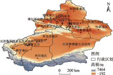
图1
研究区位置示意图 注:底图采用自然资源部标准地图制作,审图号为GS(2019)3333号,底图边界无修改。下同。"

表1
数据来源与处理方法"
| 数据名称 | 数据来源 | 数据处理 |
|---|---|---|
| DEM数据 | 地理空间数据云( | 选取的地形因子主要包括高程、坡度、地形起伏度等因子,采用ArcGIS 10.2的Spatial Analyst 模块的Slope和Surface Analysis工具对新疆DEM影像计算坡度和地形起伏度。 |
| 年平均降水量 | 中国气象数据网( | 选取新疆37个国家一般气象站每月气象数据,温度和降水数据以月为尺度的点数据,时间周期为2000年、2005年、2010年、2015年和2018年,采用反距离权重法对月气象点数据进行插值,得到5期共60个月的气象因子栅格数据。 |
| ≥10 ℃积温栅格数据 | ||
| 人口密度 | 《中国统计年鉴》(2001—2019)、《新疆统计年鉴》(2001—2019)、新疆国民经济和社会发展统计公报[ | 通过统计年鉴、国民经济和社会发展统计公报,统计整理得到新疆各地州的社会经济指标数据,采用反距离权重法进行插值,得到2000年、2005年、2010年、2015年和2018年5期的社会经济栅格数据。 |
| 人均GDP | ||
| 人均耕地面积 | ||
| 第二产业比重 | ||
| 归一化植被指数(NDVI) 土地利用数据 干燥度 土壤侵蚀数据 | 中国科学院资源环境科学数据中心( | 通过像元二分模型和栅格计算器计算研究区归一化植被指数。 |
| 所有空间数据统一重采样为1 km×1 km,为保证采用的指标具有良好的空间重合性,所有栅格数据均统一到同一投影和坐标系(Albers地图投影和Krasovsky-1940坐标系)。 |
表2
SRP模型相关计算公式及参数说明"
| 指标名称 | 计算公式 | 参数说明 |
|---|---|---|
| 生境质量指数 | ||
| 生态敏感性 | S为生态敏感性;W1生态敏感性的权重;Si生态敏感性指标值。 | |
| 生态恢复力 | R为生态恢复力;W2生态恢复力的权重;Ri生态恢复力指标值。 | |
| 生态压力度 | P为生态压力度;W3生态压力度的权重;Pi生态压力度指标值。 | |
| 生态脆弱性指数 | EVIn为某一年的生态脆弱性指数,其值越大生态环境越脆弱,生态系统受到的破坏程度越明显;x1, x2, …, xk为对应指标权重;PC1, PC2, …, PCk为累积贡献率大于85%的前k个主成分,n为年份。 | |
| 生态脆弱性 综合指数 | EVSI为生态脆弱性综合指数; |
表3
基于SRP模型的新疆生态脆弱性评价指标体系"
| 总目标层 | 子目标层 | 准则层 | 指标层 | 属性 |
|---|---|---|---|---|
| 新疆生态脆弱性指数 | 生态敏感性 | 地形因子 | 高程 | + |
| 坡度 | + | |||
| 地形起伏度 | + | |||
| 地表因子 | 土地垦殖率 | + | ||
| 景观破碎度 | + | |||
| 土壤侵蚀程度 | + | |||
| 气象因子 | 干燥度 | + | ||
| 年均降水量 | - | |||
| ≥10 ℃积温 | - | |||
| 生态恢复力 | 植被因子 | 植被覆盖度 | - | |
| 景观恢复力指数 | - | |||
| 生境质量指数 | - | |||
| 生态压力度 | 社会因子 | 人口密度 | + | |
| 农业依赖度 | + | |||
| 人均GDP | + | |||
| 人均耕地面积 | + | |||
| 第二产业比重 | + |
表4
2000—2018年新疆生态脆弱性指标主成分分析结果"
| 主成分 | 2000年 | 2005年 | 2010年 | 2015年 | 2018年 | ||||||||||||||
|---|---|---|---|---|---|---|---|---|---|---|---|---|---|---|---|---|---|---|---|
| 特征值 | 贡献率/% | 累计贡献率/% | 特征值 | 贡献率/% | 累计贡献率/% | 特征值 | 贡献率/% | 累计贡献率/% | 特征值 | 贡献率/% | 累计贡献率/% | 特征值 | 贡献率/% | 累计贡献率/% | |||||
| 1 | 0.17 | 37.79 | 37.79 | 0.18 | 38.67 | 38.67 | 0.16 | 37.06 | 37.06 | 0.16 | 37.39 | 37.39 | 0.17 | 36.04 | 36.04 | ||||
| 2 | 0.10 | 23.07 | 60.86 | 0.11 | 22.73 | 61.39 | 0.10 | 23.18 | 60.25 | 0.10 | 23.02 | 60.40 | 0.10 | 20.62 | 56.65 | ||||
| 3 | 0.06 | 14.37 | 75.23 | 0.06 | 12.77 | 74.17 | 0.07 | 15.61 | 75.85 | 0.05 | 12.58 | 72.98 | 0.06 | 11.73 | 68.38 | ||||
| 4 | 0.03 | 6.29 | 81.52 | 0.03 | 6.66 | 80.83 | 0.03 | 6.34 | 82.19 | 0.03 | 6.70 | 79.68 | 0.04 | 8.38 | 76.76 | ||||
| 5 | 0.02 | 5.05 | 86.57 | 0.03 | 5.57 | 86.40 | 0.02 | 4.89 | 87.08 | 0.03 | 6.16 | 85.84 | 0.03 | 6.29 | 83.05 | ||||
| 6 | 0.02 | 3.77 | 90.34 | 0.02 | 4.05 | 90.44 | 0.01 | 3.28 | 90.36 | 0.02 | 4.10 | 89.94 | 0.02 | 4.95 | 88.00 | ||||
| 7 | 0.01 | 2.72 | 93.06 | 0.01 | 2.98 | 93.42 | 0.01 | 2.75 | 93.11 | 0.02 | 3.68 | 93.63 | 0.02 | 4.25 | 92.25 | ||||
| 8 | 0.01 | 2.27 | 95.33 | 0.01 | 2.49 | 95.91 | 0.01 | 2.36 | 95.47 | 0.01 | 2.06 | 95.69 | 0.02 | 3.23 | 95.48 | ||||
| 9 | 0.01 | 1.37 | 96.70 | 0.01 | 1.40 | 97.31 | 0.01 | 1.46 | 96.93 | 0.01 | 1.49 | 97.18 | 0.01 | 1.35 | 96.83 | ||||
| 10 | 0.01 | 1.12 | 97.81 | 0.01 | 1.21 | 98.52 | 0.00 | 1.08 | 98.01 | 0.00 | 1.06 | 98.24 | 0.01 | 1.26 | 98.09 | ||||
| 11 | 0.00 | 0.78 | 98.59 | 0.00 | 0.47 | 98.99 | 0.00 | 0.65 | 98.67 | 0.00 | 0.53 | 98.76 | 0.00 | 0.88 | 98.97 | ||||
| 12 | 0.00 | 0.63 | 99.22 | 0.00 | 0.30 | 99.29 | 0.00 | 0.41 | 99.07 | 0.00 | 0.34 | 99.10 | 0.00 | 0.37 | 99.34 | ||||
| 13 | 0.00 | 0.25 | 99.47 | 0.00 | 0.26 | 99.55 | 0.00 | 0.34 | 99.42 | 0.00 | 0.31 | 99.42 | 0.00 | 0.28 | 99.61 | ||||
| 14 | 0.00 | 0.24 | 99.71 | 0.00 | 0.22 | 99.77 | 0.00 | 0.24 | 99.66 | 0.00 | 0.28 | 99.70 | 0.00 | 0.21 | 99.82 | ||||
| 15 | 0.00 | 0.21 | 99.91 | 0.00 | 0.16 | 99.93 | 0.00 | 0.20 | 99.86 | 0.00 | 0.13 | 99.83 | 0.00 | 0.11 | 99.93 | ||||
| 16 | 0.00 | 0.05 | 99.96 | 0.00 | 0.05 | 99.98 | 0.00 | 0.09 | 99.95 | 0.00 | 0.12 | 99.95 | 0.00 | 0.05 | 99.98 | ||||
| 17 | 0.00 | 0.04 | 100 | 0.00 | 0.02 | 100 | 0.00 | 0.05 | 100 | 0.00 | 0.05 | 100 | 0.00 | 0.02 | 100 | ||||
表5
SRP模型的生态脆弱性分级标准"
| 等级 | 取值范围 | 敏感性 | 恢复力 | 压力度 | 脆弱性 |
|---|---|---|---|---|---|
| 1级 | ≤0.2 | 微度敏感 | 恢复力弱 | 生态压力小 | 微度脆弱 |
| 2级 | 0.2~0.4 | 轻度敏感 | 恢复力较弱 | 生态压力较小 | 轻度脆弱 |
| 3级 | 0.4~0.6 | 中度敏感 | 恢复力一般 | 生态压力中等 | 中度脆弱 |
| 4级 | 0.6~0.8 | 重度敏感 | 恢复力较强 | 生态压力较大 | 强度脆弱 |
| 5级 | >0.8 | 极度敏感 | 恢复力强 | 生态压力大 | 重度脆弱 |
表6
生态脆弱性指数各指标权重"
| 生态脆弱性指数 | 指标 | 权重 |
|---|---|---|
| 生态敏感性指数 | 高程 | 0.130 |
| 坡度 | 0.033 | |
| 地形起伏度 | 0.073 | |
| 土地垦殖率 | 0.037 | |
| 景观破碎度 | 0.241 | |
| 土壤侵蚀程度 | 0.221 | |
| 干燥度 | 0.150 | |
| 年均降水量 | 0.045 | |
| ≧10 ℃积温 | 0.070 | |
| 生态恢复力指数 | 植被覆盖度 | 0.574 |
| 景观恢复力指数 | 0.184 | |
| 生境质量指数 | 0.142 | |
| 生态压力度指数 | 人均耕地面积 | 0.035 |
| 农业依赖度 | 0.323 | |
| 人均GDP | 0.267 | |
| 人口密度 | 0.315 | |
| 第二产业比重 | 0.059 |

图2
生态敏感性空间格局分布"
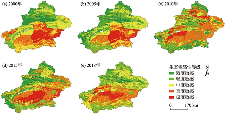
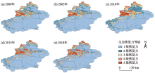
图3
新疆生态恢复力空间格局分布"


图4
新疆生态压力度空间格局分布"

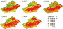
图5
新疆生态脆弱性空间分布"

表7
新疆脆弱区面积转移矩阵"
| 脆弱等级 | 2018年 | |||||
|---|---|---|---|---|---|---|
| 微度脆弱 | 轻度脆弱 | 中度脆弱 | 重度脆弱 | 极度脆弱 | ||
| 2000年 | 微度脆弱 | 36117.16 | 12027.91 | 5579.62 | 200.47 | 0.00 |
| 轻度脆弱 | 91913.32 | 105010.38 | 62277.87 | 35148.24 | 2973.57 | |
| 中度脆弱 | 41128.79 | 115768.69 | 108251.23 | 84228.82 | 34847.54 | |
| 重度脆弱 | 5846.90 | 38589.56 | 80587.03 | 127295.40 | 88137.89 | |
| 极度脆弱 | 601.40 | 5212.10 | 26795.52 | 246505.43 | 296655.16 | |
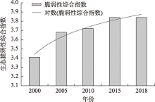
图6
新疆生态脆弱性综合指数变化"
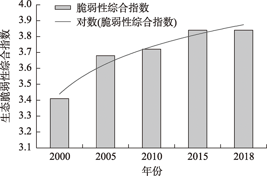
表8
主要指标之间交互作用"
| 交互类型 | q值 | 交互类型 | q值 |
|---|---|---|---|
| 农业依赖度∩景观恢复力 | 0.325 | 景观破碎度∩生境质量指数 | 0.270 |
| 农业依赖度∩景观破碎度 | 0.455 | 景观破碎度∩植被覆盖度 | 0.246 |
| 农业依赖度∩生境质量指数 | 0.446 | 景观破碎度∩人口密度 | 0.308 |
| 农业依赖度∩植被覆盖度 | 0.333 | 景观破碎度∩土地垦殖率 | 0.110 |
| 农业依赖度∩年均降水量 | 0.114 | 生境质量指数∩植被覆盖度 | 0.322 |
| 农业依赖度∩土地垦殖率 | 0.276 | 生境质量指数∩人口密度 | 0.114 |
| 农业依赖度∩高程 | 0.057 | 生境质量指数∩土地垦殖率 | 0.257 |
| 景观恢复力∩景观破碎度 | 0.172 | 第二产业比重∩年均降水量 | 0.119 |
| 景观恢复力∩生境质量指数 | 0.453 | 植被覆盖度∩人口密度 | 0.279 |
| 景观恢复力∩植被覆盖度 | 0.295 | 植被覆盖度∩土地垦殖率 | 0.323 |
| 景观恢复力∩人口密度 | 0.361 | 人均GDP∩年均降水量 | 0.113 |
| 景观恢复力∩土地垦殖率 | 0.124 | 人口密度∩土地垦殖率 | 0.090 |
| [1] |
Turvey R. Vulnerability assessment of developing countries: The case of small island developing states[J]. Development Policy Review, 2007, 25(2): 243-264.
doi: 10.1111/dpr.2007.25.issue-2 |
| [2] |
Mahapatra M, Ramakrishnan R, Rajawat A S. Coastal vulnerability assessment using analytical hierarchical process for South Gujarat coast, India[J]. Natural Hazards, 2015, 76(1): 139-159.
doi: 10.1007/s11069-014-1491-y |
| [3] | 曹诗颂, 王艳慧, 段福洲, 等. 中国贫困地区生态环境脆弱性与经济贫困的耦合关系——基于连片特困区714个贫困县的实证分析[J]. 应用生态学报, 2016, 27(8): 2614-2622. |
| [Cao Shisong, Wang Yanhui, Duan Fuzhou, et al. Coupling between ecological China: Empirical analysis vulnerability and economic poverty in contiguous destitute areas of 714 poverty-stricken counties[J]. Chinese Journal of Applied Ecology, 2016, 27(8): 2614-2622. ] | |
| [4] | 王贝贝, 丁明军, 管琪卉, 等. 基于格网的南昌市生态环境脆弱性评价[J]. 生态学报, 2019, 39(15): 5460-5472. |
| [Wang Beibei, Ding Mingjun, Guan Qihui, et al. Gridded assessment of eco-environmental vulnerability in Nanchang city[J]. Acta Ecologica Sinica, 2019, 39(15): 5460-5472. ] | |
| [5] | 王让会, 樊自立. 干旱区内陆河流域生态脆弱性评价——以新疆塔里木河流域为例[J]. 生态学杂志, 2001, 20(3): 63-68. |
| [Wang Ranghui, Fan Zili. Ecological fragility assessment on continental river basin in arid zone taking Tarim River basin, Xinjiang as an example[J]. Chinese Journal of Ecology, 2001, 20(3): 63-68. ] | |
| [6] | 谢霞, 王宏卫. 艾比湖区域生态脆弱性评估与保护[J]. 新疆农业科学, 2012, 49(3): 531-536. |
| [Xie Xia, Wang Hongwei, Eco-environmental vulnerability evaluation and countermeasures in Ebinur lake region[J]. Xinjiang Agricultural Sciences, 2012, 49(3): 531-536. ] | |
| [7] | 万洪秀, 孙占东, 王润. 博斯腾湖湿地生态脆弱性评价研究[J]. 干旱区地理, 2006, 29(2): 248-254. |
| [Wan Hongxiu, Sun Zhandong, Wang Run. Study on the evaluation of ecological frangibility of the wetlands in the Bosten Lake region[J]. Arid Land Geography, 2006, 29(2): 248-254. ] | |
| [8] | 师庆东, 王智, 贺龙梅, 等. 基于气候、地貌、生态系统的景观分类体系——以新疆地区为例[J]. 生态学报, 2014, 34(12): 3359-3367. |
| [Shi Qingdong, Wang Zhi, He Longmei, et al. Landscape classification system based on climate, landform, ecosystem: A case study of Xinjiang area[J]. Acta Ecologica Sinica, 2014, 34(12): 3359-3367. ] | |
| [9] | 张宁宁, 房世峰, 杜加强, 等. 基于LUCC的新疆沙尘源空间格局及转化机理分析[J]. 干旱区地理, 2018, 41(5): 1053-1063. |
| [Zhang Ningning, Fang Shifeng, Du Jiaqiang, et al. Transformation and spatio-temporal distribution of sand-dust sources in Xinjiang based on LUCC[J]. Arid Land Geography, 2018, 41(5): 1053-1063. ] | |
| [10] | 郭兵, 孔维华, 姜琳. 西北干旱荒漠生态区脆弱性动态监测及驱动因子定量分析[J]. 自然资源学报, 2018, 33(3): 412-424. |
| [Guo Bing, Kong Weihua, Jiang Lin. Dynamic monitoring of ecological vulnerability in arid desert ecological region of Northwest China and the quantitative analysis of its driving forces[J]. Journal of Natural Resources, 2018, 33(3): 412-424. ] | |
| [11] | 新疆维吾尔自治区统计局. 国家统计局新疆调查总队. 新疆维吾尔自治区2018年国民经济和社会发展统计公报[N]. 新疆日报, 2019-03-22. |
| [Statistics Bureau of Xinjiang Uygur Autonomous Region. Xinjiang Survey Team National Bureau of Statistics. Statistical Communique of National Economic and Social Development in Xinjiang Uygur Autonomous Region in 2018[N]. Xinjiang Daily, 2019-03-22. ] | |
| [12] | 张启. 长白山地区土地利用/覆被变化对生态环境脆弱性的影响评价[D]. 延吉: 延边大学, 2019. |
| [Zhang Qi. The Impact Assessment of Ecological Enviorment Vulnerability Based on Land Use/Cover Change in Changbai Mountain Area[D]. Yanji: Yanbian University, 2019. ] | |
| [13] | 马骏. 三峡库区重庆段生态脆弱性动态评价[D]. 重庆: 西南大学, 2014. |
| [Ma Jun. Dynamic Evaluation of Ecological Vulnerability in the Three Gorges Reservoir Region in Chongqing Section, China[D]. Chongqing: Southwest University, 2014. ] | |
| [14] | 刘正佳, 于兴修, 李蕾, 等. 基于SRP概念模型的沂蒙山区生态环境脆弱性评价[J]. 应用生态学报, 2011, 22(8): 2084-2090. |
| [Liu Zhengjia, Yu Xingxiu, Li Lei, et al. Spatio-temporal change of ecological vulnerability in Yimeng Mountain based on SRP model and driving force analysis[J]. Journal of Applied Ecology, 2011, 22(8): 2084-2090. ] | |
| [15] | 韦晶, 郭亚敏, 孙林, 等. 三江源地区生态环境脆弱性评价[J]. 生态学杂志, 2015, 34(7): 1968-1975. |
| [Wei Jing, Guo Yamin, Sun Lin, et al. Evaluation of ecological environment vulnerability in the Three-River Source region[J]. Journal of Ecology, 2015, 34(7): 1968-1975. ] | |
| [16] | 张行, 陈海, 史琴琴, 等. 陕西省景观生态脆弱性时空演变及其影响因素[J]. 干旱区研究, 2020, 37(2): 496-505. |
| [Zhang Hang, Chen Hai, Shi Qinqin, et al. Spatio-temporal evolution and driving factors of landscape ecological vulnerability in Shaanxi Province[J]. Arid Zone Research, 2020, 37(2): 496-505. ] | |
| [17] |
Zang Z, Zou X, Zuo P, et al. Impact of landscape patterns on ecological vulnerability and ecosystem service values: An empirical analysis of Yancheng Nature Reserve in China[J]. Ecological Indicators, 2017, 72: 142-152.
doi: 10.1016/j.ecolind.2016.08.019 |
| [18] | 杨海娟, 温晓金, 刘焱序, 等. 秦岭土石山区土地利用程度对生态恢复力的影响评价[J]. 水土保持通报, 2012, 32(4): 261-266. |
| [Yang Haijuan, Wen Xiaojin, Liu Yanxu, et al. Impact evaluation of land use degree on ecological resilience in Qinling earth-rock mountainous area[J]. Bulletin of Soil and Water Conservation, 2012, 32(4): 261-266. ] | |
| [19] |
王俊, 杨新军, 刘文兆. 半干旱区社会-生态系统干旱恢复力的定量化研究[J]. 地理科学进展, 2010, 29(11): 1385-1390.
doi: 10.11820/dlkxjz.2010.11.028 |
|
[Wang Jun, Yang Xinjun, Liu Wenzhao. Quantitative research on drought resilience of social-ecosystem in semi-arid area[J]. Progress in Geography, 2010, 29(11): 1385-1390. ]
doi: 10.11820/dlkxjz.2010.11.028 |
|
| [20] | 赵先贵, 马彩虹, 高利峰, 等. 基于生态压力指数的不同尺度区域生态安全评价[J]. 中国生态农业学报, 2007, 15(6): 135-138. |
| [Zhao Xiangui, Ma Caihong, Gao Lifeng, et al. Evaluation of regional ecological security at different ccales based on ecological pressure index[J]. Chinese Journal of Eco-Agriculture, 2007, 15(6): 135-138. ] | |
| [21] | 姚雄, 余坤勇, 刘健, 等. 南方水土流失严重区的生态脆弱性时空演变[J]. 应用生态学报, 2016, 27(3): 735-745. |
| [Yao Xiong, Yu Kunyong, Liu Jian, et al. Temporal and spatial evolution of ecological vulnerability in the severe soil erosion area in south China[J]. Chinese Journal of Applied Ecology, 2016, 27(3): 735-745. ] | |
| [22] |
Fatemi F, Ardalan A, Aguirre B, et al. Social vulnerability indicator in disasters: Fingdings from a systematic review[J]. International Journal of Disaster Risk Reduction, 2017, 22: 219-227.
doi: 10.1016/j.ijdrr.2016.09.006 |
| [23] |
王钰, 胡宝清. 西江流域生态脆弱性时空分异及其驱动机制研究[J]. 地球信息科学学报, 2018, 20(7): 947-956.
doi: 10.12082/dqxxkx.2018.170633 |
|
[Wang Yu, Hu Baoqing. Study on the spatial and temporal differentiation of ecological vulnerability in Xijiang River basin and its driving mechanism[J]. Journal of Geo-information Science, 2018, 20(7): 947-956. ]
doi: 10.12082/dqxxkx.2018.170633 |
|
| [24] | 付刚, 白加德, 齐月, 等. 基于GIS的北京市生态脆弱性评价[J]. 生态与农村环境学报, 2018, 34(9): 830-839. |
| [Fu Gang, Bai Jiade, Qi Yue, et al. Evaluation of ecological vulnerability in Beijing based on GIS[J]. Journal of Ecology and Rural Environment, 2018, 34(9): 830-839. ] | |
| [25] | 张德君, 高航, 杨俊, 等. 基于GIS的南四湖湿地生态脆弱性评价[J]. 资源科学, 2014, 36(4): 874-882. |
| [Zhang Dejun, Gao Hang, Yang Jun, et al. Evaluation of ecological vulnerability of Nansi lake wetland based on GIS[J]. Resources Science, 2014, 36(4): 874-882. ] | |
| [26] |
Wang J F, LI X H, Christakos G, et al. Geographical detectors-based health risk assessment and its application in the neural tube defects study of the Heshun region[J]. International Journal of Geographical Information Science, 2010, 24(1): 107-127.
doi: 10.1080/13658810802443457 |
| [27] |
王劲峰, 徐成东. 地理探测器: 原理与展望[J]. 地理学报, 2017, 72(1): 116-134.
doi: 10.11821/dlxb201701010 |
|
[Wang Jinfeng, Xu Chendong. Geodetector: Principles and prospects[J]. Acta Geographica Sinica, 2017, 72(1): 116-134. ]
doi: 10.11821/dlxb201701010 |
|
| [28] | 黄莹, 包安明, 刘海隆, 等. 基于景观格局的新疆生态脆弱性综合评价研究[J]. 干旱地区农业研究, 2009, 27(3): 261-266. |
| [Huang Ying, Bao Anming, Liu Hailong, et al. Research on comprehensive evaluation of Xinjiang ecological vulnerability based on landscape pattern[J]. Agricultural Research in the Arid Areas, 2009, 27(3): 261-266. ] | |
| [29] | 郭亚淑. 福州市土地利用/覆被变化对生态环境脆弱性的影响评价[D]. 福州: 福建农林大学, 2016. |
| [Guo Yashu. The Impact Assessment of Eco-environment Based on Land Use/Cover Change in Fuzhou City[D]. Fuzhou: Fujian Agriculture and Forestry University, 2016. ] | |
| [30] | 艾丽娅, 王少军, 张志. 1977—2017年锡林郭勒盟中部草原植被覆盖时空演变及预测[J]. 水土保持通报, 2019, 39(5): 249-256, 277, 347. |
| [Ai Liya, Wang Shaojun, Zhang Zhi. . Spatio-temporal evolution and Spatio-temporal evolution and prediction of grassland vegetation coverage in central Xilin Gol League from 1977 to 2017[J]. Bulletin of Soil and Water Conservation, 2019, 39(5): 249-256, 277, 347. ] | |
| [31] | 于琳. 新疆绿洲生态经济系统可持续发展研究[D]. 重庆: 西南大学, 2006. |
| [Yu Lin. Research on Sustainable Development of Xinjiang Oasis Eco-economy System[D]. Chongqing: Southwest University, 2006. ] | |
| [32] |
鲁大铭, 石育中, 李文龙, 等. 西北地区县域脆弱性时空格局演变[J]. 地理科学进展, 2017, 36(4): 404-415.
doi: 10.18306/dlkxjz.2017.04.002 |
|
[Lu Daming, Shi Yuzhong, Li Wenlong, et al. Spatio-temporal change of vulnerability in counties of Northwest China[J]. Progress in Geography, 2017, 36(4): 404-415. ]
doi: 10.18306/dlkxjz.2017.04.002 |
|
| [33] | 茹克亚·萨吾提, 阿不都艾尼·阿不里, 李虎, 等. 基于遥感生态指数模型的阜康市生态环境动态变化监测与评价[J]. 水土保持研究, 2020, 27(1): 283-289, 297. |
| [Rukeya Sawuti, Abuduaini Abuli, Li Hu, et al. Dynamic monitoring and analysis fukang city based ecological environment in RSEI model[J]. Research of Soil and Water Conscrvation, 2020, 27(1): 283-289, 297. ] | |
| [34] |
Pei H, Fang S F, Lin L, et al. Methods and applications for ecological vulnerability evaluation in a hyper-arid oasis: A case study of the Turpan Oasis, China[J]. Environmental Earth Sciences, 2015, 74(2): 1449-1461.
doi: 10.1007/s12665-015-4134-z |
| [1] | 李小锋, 惠婷婷, 李耀明, 毛洁菲, 王光宇, 范连连. 不同放牧管理方式对新疆山地草原植物群落特征的影响[J]. 干旱区研究, 2024, 41(1): 124-134. |
| [2] | 陈爱军,张寅,楚志刚. 基于FY-4A QPE的中亚五国降水时空分布特征[J]. 干旱区研究, 2023, 40(9): 1369-1381. |
| [3] | 汪翔, 吕海深, 朱永华, 郭晨煜. 两种河道洪水演进方法在新疆山区的应用比较[J]. 干旱区研究, 2023, 40(8): 1240-1247. |
| [4] | 王超, 马占仓, 潘成南, 吴星月, 宋文丹, 阎平. 新疆苋属新记录植物[J]. 干旱区研究, 2023, 40(8): 1280-1288. |
| [5] | 古丽斯旦·艾尼瓦尔, 吐尔洪·努尔东, 地力胡马尔·阿不都克热木, 买买提明·苏来曼. 新疆薄罗藓科植物新记录[J]. 干旱区研究, 2023, 40(8): 1289-1293. |
| [6] | 文妙霞, 何学高, 刘欢, 张婧, 罗晨, 贾丰铭, 王义贵, 胡云云. 基于地理探测器的宁夏草地植被覆被时空分异及驱动因子[J]. 干旱区研究, 2023, 40(8): 1322-1332. |
| [7] | 李虹, 李忠勤, 陈普晨, 彭加加. 近20 a新疆阿尔泰山积雪时空变化及其影响因素[J]. 干旱区研究, 2023, 40(7): 1040-1051. |
| [8] | 孟乘枫, 仲涛, 郑江华, 王南, 刘泽轩, 任祥源. 昆仑山冰湖分布时空特征及驱动力[J]. 干旱区研究, 2023, 40(7): 1094-1106. |
| [9] | 齐润泽, 潘竟虎. 河湟地区生态脆弱性时空演变及影响因素研究[J]. 干旱区研究, 2023, 40(6): 1002-1013. |
| [10] | 许君利, 韩海东, 王建. 新疆大气PM2.5来源与潜在贡献源分析[J]. 干旱区研究, 2023, 40(6): 874-884. |
| [11] | 薛一波, 黄双燕, 张小啸, 雷加强, 李生宇. 新疆2018年冬季雨雪风沙强降尘事件[J]. 干旱区研究, 2023, 40(5): 681-690. |
| [12] | 赵克明, 孙鸣婧, 李霞, 施俊杰, 安大维, 许婷婷. 两种典型大气扩散指数在新疆的分布特征及其适用性对比[J]. 干旱区研究, 2023, 40(5): 691-702. |
| [13] | 董翰林, 王文婷, 谢云, 阿依达娜·叶斯那力, 江源天, 徐嘉淇. 新疆气候干湿变化特征及其影响因素[J]. 干旱区研究, 2023, 40(12): 1875-1884. |
| [14] | 张宗芳, 徐将, 师小军. 新疆野苹果幼苗生长及生物量分配对降水量和降水间隔时间的响应[J]. 干旱区研究, 2023, 40(1): 102-110. |
| [15] | 苗运玲, 于永波, 霍达, 潘存良, 李如琦. 中天山北坡冬季降雪变化及其影响因子分析[J]. 干旱区研究, 2023, 40(1): 9-18. |
|
||