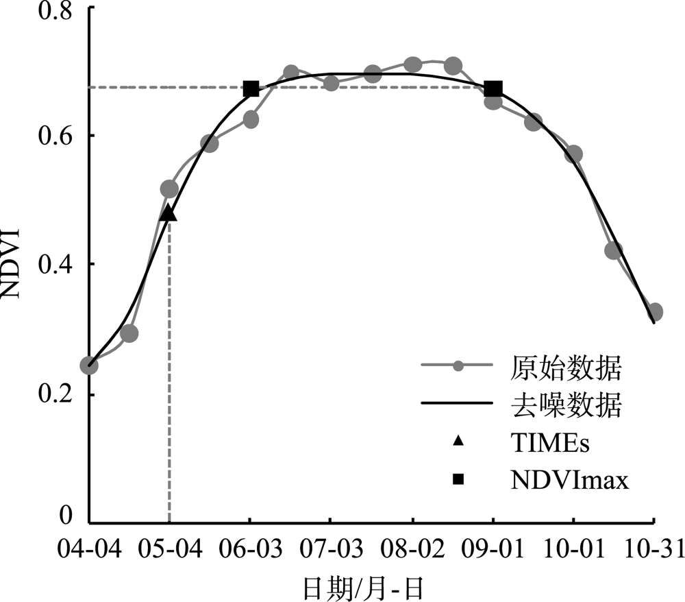
| [1] |
Li J, Xu B, Yang X, et al. Historical grassland desertification changes in the Horqin Sandy Land, Northern China (1985-2013)[J]. Scientific Reports, 2017,7(3009):1-12.
|
| [2] |
Zhang G, Dong J, Xiao X, et al. Effectiveness of ecological restoration projects in Horqin Sandy Land, China based on SPOT-VGT NDVI data[J]. Ecological Engineering, 2012,38(1):20-28.
|
| [3] |
Duan H, Wang T, Xue X, et al. Dynamics of aeolian desertification and its driving forces in the Horqin Sandy Land, Northern China[J]. Environ Monit Assess, 2014,186:6083-6096.
pmid: 24891073
|
| [4] |
那音太, 乌兰图雅, 秦福莹. 基于3S技术的科尔沁沙地土地荒漠化动态监测——以科尔沁左翼后旗为例[J]. 干旱区资源与环境, 2010,24(10):50-54.
|
|
[ Na Yintai, Wulan Tuya, Qin Fuying. Dynamic monitoring of Horqin sandy land desertification based on 3S techniques: A case study in Horqin Left Wing Banner[J]. Journal of Arid Land Resources and Environment, 2010,24(10):50-54. ]
|
| [5] |
Zheng X, Zhu J J, Yan Q L, et al. Effects of land use changes on the groundwater table and the decline of Pinus sylvestris var. mongolica plantations in southern Horqin Sandy Land, Northeast China[J]. Agricultural Water Management, 2012,109:94-106.
|
| [6] |
焦树仁. 辽宁省章古台樟子松固沙林提早衰退的原因与防治措施[J]. 林业科学, 2001,37(2):131-138.
|
|
[ Jiao Shuren. Report on the causes of the early decline of Pinus slyvestris var. Mongolica shelterbelt and its preventaive and control measures in Zhang Gutai of Liaoning Province[J]. Scientia Silvae Sinicae, 2001,37(2):131-138. ]
|
| [7] |
Li X R, Xiao H L, Zhang J G, et al. Long-term ecosystem effects of sand-binding vegetation in the Shapotou Region of the Tengger Desert, Northern China[J]. Restoration Ecology, 2004,12(3):376-390.
|
| [8] |
陈百明, 刘新卫, 杨红. LUCC 研究的最新进展评述[J]. 地理科学进展, 2003,22(1):22-29.
|
|
[ Chen Baiming, Liu Xingwei, Yang Hong. Review of most recent progresses of study on land use and land cover change[J]. Progress in Geography, 2003,22(1):22-29. ]
|
| [9] |
Wang Y, Zhang J, Tong S, et al. Monitoring the trends of aeolian desertified lands based on time-series remote sensing data in the Horqin Sandy Land, China[J]. Catena, 2017,157:286-298.
|
| [10] |
He K S, Rocchini D, Neteler M, et al. Benefits of hyperspectral remote sensing for tracking plant invasions Divers[J]. Diversity and Distribution, 2011,17:381-392.
|
| [11] |
Vicente J, Randin C F, Gonçalves J, et al. Where will conflicts between alien and rare species occur after climate and land-use change? A test with a novel combined modelling approach[J]. Biological Invasions, 2011,13:1209-1227.
|
| [12] |
Rocchini D. Effects of spatial and spectral resolution in estimating ecosystem α-diversity by satellite imagery[J]. Remote Sensing Environment, 2007,111:423-434.
|
| [13] |
Nagendra H, Rocchini D, Ghate R, et al. Assessing plant diversity in a dry tropical forest: Comparing the utility of Landsat and IKONOS satellite images[J]. Remote Sensing, 2010,2(2):478-496.
|
| [14] |
Conese C, Maselli F. Use of multitemporal information to improve classification performance of TM scenes in complex terrain[J]. Remote Sensing, 1991,46:187-197.
|
| [15] |
Drusch M, Del Bello U, Carlier S, et al. Sentinel-2: ESA’s optical high-resolution mission for GMES operational services[J]. Remote Sensing Environment, 2012,120:25-36.
|
| [16] |
田颖, 陈卓奇, 惠凤鸣, 等. 欧空局哨兵卫星Sentinel-2A/B数据特征及应用前景分析[J]. 北京师范大学学报(自然科学版), 2019,55(1):57-65.
|
|
[ Tian Ying, Chen Zhuoqi, Hui Fengming, et al. ESA Sentinel-2A/B satellite: Characteristics and applications[J]. Journal of Beijing Normal University(Natural Science Edition), 2019,55(1):57-65. ]
|
| [17] |
黄天宇, 王冠丽, 李东方, 等. 科尔沁沙地沙丘——草甸梯级生态系统不同气象条件下气候学足迹特征[J]. 干旱区研究, 2019,36(5):1127-1135.
|
|
[ Huang Tianyu, Wang Guanli, Li Dongfang, et al. Climatological footprints in dune-meadow cascade ecosystem under different meteorological conditions in the Horqin Sandy Land[J]. Arid Zone Research, 2019,36(5):1127-1135. ]
|
| [18] |
Müller-Wilm, U. Sen2Cor 2. 5. 5—Software Release Note[EB/OL]. https://step.esa.int/main/new-release-of-sen2cor-2-5-5, 2019-2-4.
|
| [19] |
Hutchings M J. Weight-density relationships in ramet populations of clonal perennial herbs, with special reference to the -3/2 power law[J]. Journal of Ecology, 1979,67(1):21-33.
|
| [20] |
Shannon C E. A mathematica theory of communication[J]. Bell System Technical Journal, 1948,27(3):479-523.
|
| [21] |
曹文梅, 刘小燕, 王冠丽, 等. 科尔沁沙地自然植被与生境因子的MRT分类及DCCA分析[J]. 生态学杂志, 2017,36(2):318-327.
|
|
[ Cao Wenmei, Liu Xiaoyan, Wang Guanli, et al. Combined analyses of MRT and DCCA on relationships between plant community distribution and ecological factors of Horqin Sandy Land[J]. Chinese Journal of Ecology, 2017,36(2):318-327. ]
|
| [22] |
包永志, 刘廷玺, 段利民, 等. 科尔沁沙地混生小叶锦鸡儿和人工杨树光合特性及其对气候的响应[J]. 干旱区研究, 2019,36(2):420-429.
|
|
[ Bao Yongzhi, Liu Tingxi, Duan Limin, et al. Photosynthetic traits of Caragana microphylla and Populus spp. and their responses to climate in the Horqin Sandy Land[J]. Arid Zone Research, 2019,36(2):420-429. ]
|
| [23] |
Benz U C, Hofmann P, Willhauck G, et al. Multi-resolution, object-oriented fuzzy analysis of remote sensing data for GIS-ready information[J]. SPRS Journal of Photogrammetry & Remote Sensing, 2004,58:239-258.
|
| [24] |
Trimble Germany Gmb H. eCognition Developer 8. 9 User Guide[EB/OL]. Trimble Germany GmbH, Munich, Germany, 2013.
|
| [25] |
滑永春, 李增元, 高志海. 面向对象分割与混合像元分解相结合提取沙化土地信息[J]. 干旱区研究, 2020,37(5):1346-1352.
|
|
[ Hua Yongchun, Li Zengyuan, Gao Zhihai. Extraction of sand information using object-oriented segmentation combined with decomposition of mixed pixels[J]. Arid Zone Research, 2020,37(5):1346-1352. ]
|
| [26] |
邬亚娟, 刘廷玺, 童新, 等. 基于面向对象的干旱半干旱地区植被分类[J]. 干旱区研究, 2020,37(4):1026-1034.
|
|
[ Wu Yajuan, Liu Tingxi, Tong Xin, et al. Vegetation classification in arid and semi-arid areas using an object-oriented method[J]. Arid Zone Research, 2020,37(4):1026-1034. ]
|
| [27] |
Drǎgu L, Csillik O, Eisank C, et al. Automated parameterisation for multi-scale image segmentation on multiple layers[J]. ISPRS Journal Photogramm Remote Sensing, 2014,88(100):119-127.
|
| [28] |
Beck P S A, Atzberger C, Høgda K A, et al. Improved monitoring of vegetation dynamics at very high latitudes: A new method using MODIS NDVI[J]. Remote Sensing of Environment, 2006,99:321-334.
|
| [29] |
Jönsson P, Eklundh L. TIMESAT: A program for analyzing time-series of satellite sensor data[J]. Computers & Geosciences, 2004,30:833-845.
|
| [30] |
李苗苗. 植被覆盖度的遥感估算方法研究[D]. 北京: 中国科学院, 2003.
|
|
[ Li Miaomiao. The Study on Remote Sensing Estimation Method of Vegetation Coverage[D]. Beijing: Chinese Academy of Sciences, 2003. ]
|
| [31] |
王永芳, 张继权, 马齐云, 等. 21 世纪初科尔沁沙地沙漠化对区域气候变化的响应[J]. 农业工程学报, 2016,32(2):177-185.
|
|
[ Wang Yongfang, Zhang Jiquan, Ma Qiyun, et al. Response of aeolian desertification to regional climate change in Horqinsandy land at beginning of 21st century[J]. Transactions of the Chinese Society of Agricultural Engineering, 2016,32(2):177-185. ]
|
| [32] |
史小红, 李畅游, 刘廷玺. 科尔沁沙地坨甸相间地区土壤水分空间分布特性分析[J]. 中国沙漠, 2007,27(5):837-842.
|
|
[ Shi Xiaohong, Li Changyou, Liu Tingxi. Analysis on spatial characteristics of soil water in marshland-dune areas in Horqin Sandy Land[J]. Journal of desert research, 2007,27(5):837-842. ]
|
| [33] |
汪求来. 面向对象遥感影像分类方法及其应用研究[D]. 南京: 南京林业大学, 2008.
|
|
[ Wang Qiulai. Study on Object-Oriented Romote Sensing Image Classification and Its Application-Taking Urban Vegetation Extraction in Futian, Shenzhen City for Example[D]. Nanjing: Nanjing Forestry University, 2008. ]
|
| [34] |
张继义, 赵哈林, 张铜会, 等. 科尔沁沙地植物群落恢复演替系列种群生态位动态特征[J]. 生态学报, 2003,23(12):2741-2746.
|
|
[ Zhang Jiyi, Zhao Haling, Zhang Tonghui, et al. Niche dynamics of main populations of plants communities in the restoring succession process in Horqin Sand Land[J]. Acta Ecologica Sinica, 2003,23(12):2741-2746. ]
|
 ),刘廷玺1(