干旱区研究 ›› 2021, Vol. 38 ›› Issue (2): 513-525.doi: 10.13866/j.azr.2021.02.23
谭惠芝1( ),尹倩1,姬莉雯1,芦倩2,卢晓宁1(),崔林林1,夏志业1,徐维新1,陈军1
收稿日期:2020-09-04
修回日期:2020-11-24
出版日期:2021-03-15
发布日期:2021-04-25
通讯作者:
卢晓宁
作者简介:谭惠芝(1996-),女,硕士研究生,主要从事干旱研究. E-mail:基金资助:
TAN Huizhi1(),YIN Qian1,JI Liwen1,LU Qian2,LU Xiaoning1(),CUI Linlin1,XIA Zhiye1,XU Weixin1,CHEN Jun1
Received:2020-09-04
Revised:2020-11-24
Online:2021-03-15
Published:2021-04-25
Contact:
Xiaoning LU
摘要:
全球气候变暖导致干旱趋势加重,对西北干旱半干旱区农牧业生产造成严重威胁。考虑到陕西省神木市具有典型的黄土高原地貌特征,以及降水对复杂地貌背景区干旱的决定性作用,本研究应用高精度的GPM(Global Precipitation Measurement)降水数据,建立土壤干旱遥感监测模型,开展能够揭示土壤相对湿度的应用分析研究。结果表明:结合GPM降水数据建立的综合植被、温度和降水的土壤干旱遥感监测模型,能准确的揭示神木市土壤表层10 cm相对湿度,模型中温度和降水的权重较高,体现出温度和降水对区域干旱的主导作用;神木市作物生长季旱情整体处于轻旱强度,平均发生频率为64.44%,且中旱>轻旱>重旱>特旱,干旱强度和发生频率均呈现出西北高东南低的空间分异特征;4—10月干旱强度整体由轻旱发展至重旱,最后干旱消失。季节上,神木市春旱现象严重,且以中旱发生频率最高。2001—2019年神木市旱情呈略微减轻趋势,但红碱淖湿地因年均气温和年蒸发量明显上升,干旱情况加剧。
谭惠芝,尹倩,姬莉雯,芦倩,卢晓宁,崔林林,夏志业,徐维新,陈军. 融合GPM降水数据的土壤干旱遥感监测[J]. 干旱区研究, 2021, 38(2): 513-525.
TAN Huizhi,YIN Qian,JI Liwen,LU Qian,LU Xiaoning,CUI Linlin,XIA Zhiye,XU Weixin,CHEN Jun. Remote sensing monitoring of soil drought in Shenmu City, Shaanxi Province integrating GPM precipitation data[J]. Arid Zone Research, 2021, 38(2): 513-525.

图1
研究区示意图"

表1
神木市2001—2019年GPM数据与站点降水数据相关系数"
| 气象站点 | Pearson相关系数 | 气象站点 | Pearson相关系数 |
|---|---|---|---|
| 神木国家站 | 0.702** | 锦界 | 0.672** |
| 大保当 | 0.685** | 栏杆堡 | 0.611** |
| 大柳塔 | 0.589** | 乔岔滩 | 0.742** |
| 店塔 | 0.562** | 沙峁 | 0.747** |
| 红碱淖 | 0.539** | 万镇 | 0.685** |
表2
每期数据对应日序"
| 期号 | 日序 | 对应季节 | 期号 | 日序 | 对应季节 |
|---|---|---|---|---|---|
| 1 | 第97~112 d | 春季 | 8 | 第209~224 d | 夏季 |
| 2 | 第113~128 d | 春季 | 9 | 第225~240 d | 夏季 |
| 3 | 第129~144 d | 春季 | 10 | 第241~256 d | 秋季 |
| 4 | 第145~160 d | 春季 | 11 | 第257~272 d | 秋季 |
| 5 | 第161~176 d | 夏季 | 12 | 第273~288 d | 秋季 |
| 6 | 第177~192 d | 夏季 | 13 | 第289~304 d | 秋季 |
| 7 | 第193~208 d | 夏季 | |||
表3
各因子与土壤相对湿度相关系数"
| 土壤表层/cm | 植被状态指数 | ||
|---|---|---|---|
| VCI | TCI | PCI | |
| 10 | 0.307* | 0.510** | 0.364* |
| 20 | 0.155 | 0.469** | 0.210 |

图2
土壤相对湿度SMMI散点图"

表4
土壤水分监测指数的干旱等级划分"
| 干旱等级 | 简称 | 土壤相对湿度 |
|---|---|---|
| 特大干旱 | 特旱 | 0.00~0.25 |
| 严重干旱 | 重旱 | 0.25~0.35 |
| 中度干旱 | 中旱 | 0.35~0.45 |
| 轻度干旱 | 轻旱 | 0.45~0.55 |
| 无旱 | 无旱 | 0.55~1.00 |
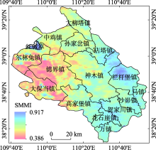
图3
神木市作物生长季(4—10月)SMMI空间分布"

表5
神木市作物生长季(4—10月)每期SMMI平均值"
| 期号 | SMMI | 干旱等级 | 期号 | SMMI | 干旱等级 |
|---|---|---|---|---|---|
| 1 | 0.475 | 轻旱 | 8 | 0.513 | 轻旱 |
| 2 | 0.407 | 中旱 | 9 | 0.575 | 无旱 |
| 3 | 0.389 | 中旱 | 10 | 0.584 | 无旱 |
| 4 | 0.349 | 重旱 | 11 | 0.629 | 无旱 |
| 5 | 0.376 | 中旱 | 12 | 0.633 | 无旱 |
| 6 | 0.404 | 中旱 | 13 | 0.664 | 无旱 |
| 7 | 0.465 | 轻旱 | |||
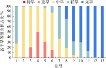
图4
神木市作物生长季(4—10月)各干旱等级面积占比"

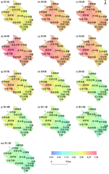
图5
神木市作物生长季(4—10月)SMMI空间分布"


图6
神木市干旱发生频率空间分布"

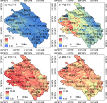
图7
神木市作物生长季(4—10月)不同等级干旱频率分布"


图8
不同时间尺度各等级干旱发生频率"
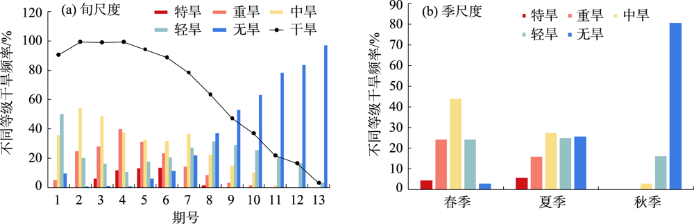

图9
神木市作物生长季植被、温度以及降水变化趋势"
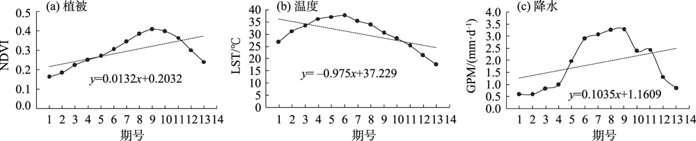

图10
神木市土壤干旱变化趋势"

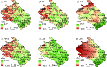
图11
神木市VCI、TCI、PCI、NDVI、LST和GPM变化趋势"

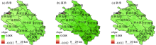
图12
神木市土壤干旱季节尺度变化趋势"

| [1] | 史本林, 朱新玉, 胡云川, 等. 基SPEI指数的近53 a河南省干旱时空变化特征[J]. 地理研究, 2017,27(3):311-325. |
| [ Shi Benlin, Zhu Xinyu, Hu Yunchuan, et al. Spatial and temporal variations of drought in Henan Province over a 53 year period based on standardized precipitation evapotranspiration index[J]. Geographical Research, 2017,27(3):311-325. ] | |
| [2] | Chang Jianxia, Li Yunyun, Wang Yimin, et al. Copula-based drought risk assessment combined with an integrated index in the Wei River Basin, China[J]. Journal of Hydrology, 2016,540:824-834. |
| [3] | Li Xiaolan, Lyu Xiang, Wang Xiaohong, et al. Biotic and abiotic stress-responsive genes are stimulated to resist drought stress in purple wheat[J]. Journal of Integrative Agriculture, 2020,19(1):33-50. |
| [4] | 高雅, 王晓飞, 高懋芳, 等. 基于温度植被干旱指数的曲靖市干旱监测研究[J]. 中国农学通报, 2020,36(9):37-45. |
| [ Gao Ya, Wang Xiaofei, Gao Maofang, et al. Drought monitoring in Qujing based on temperature vegetation drought index[J]. Chinese Agricultural Science Bulletin, 2020,36(9):37-45. ] | |
| [5] | McKee T B, Doesken N J, Kleist J. The relationship of drought frequency and duration to time scales: Proceedings of vulnerability[M]. Cambridge: Cambridge University Press, 1993: 100-184. |
| [6] | 孙博, 钱静, 陈曦, 等. 常见遥感干旱监测指标在哈萨克斯坦的一致性分析[J]. 干旱区研究, 2020,37(3):663-670. |
| [ Sun Bo, Qian Jing, Chen Xi, et al. Consistency and comparison among remote sensing drought indices and SMAP soil moisture in Kazakhstan[J]. Arid Zone Research, 2020,37(3):663-670. ] | |
| [7] | 卢晓宁, 洪佳, 王玲玲, 等. 复杂地形地貌背景区干旱风险评价[J]. 农业工程学报, 2015,31(1):162-169. |
| [ Lu Xiaoning, Hong Jia, Wang Lingling, et al. Drought risk assessment in complex landform area[J]. Transactions of the Chinese Society of Agricultural Engineering, 2015,31(1):162-169. ] | |
| [8] | Huete A, Didan K, Miura T, et al. Overview of the radiometric and biophysical performance of the MODIS vegetation indices[J]. Remote Sensing of Environment, 2002,83(1):195-213. |
| [9] | Sandholt I, Rasmussen K, Andersen J. A simple interpretation of the surface temperature/vegetation index space for assessment of surface moisture status[J]. Remote Sensing of Environment, 2002,79(2):213-224. |
| [10] | Vicente-Serrano S M, Beguería S, López-Moreno J I. Amultiscalar drought index sensitive to global warming: the standardized precipitation evapotranspiration index[J]. Journal of Climate, 2010,23(7):1696-1718. |
| [11] | 林妍, 高伟, 师晋平, 等. 基于MODIS和FY-2D卫星降水数据的遥感旱情监测研究[J]. 干旱区资源与环境, 2014,28(12):51-57. |
| [ Lin Yan, Gao Wei, Shi Jinping, et al. Remote sensing monitoring of drought based on MODIS and FY-2D satellite rainfall data[J]. Journal of Arid Land Resources and Environment, 2014,28(12):51-57. ] | |
| [12] | 卢晓宁, 张静怡, 王玲玲, 等. 综合考虑植被、温度和降水的四川省月尺度伏旱遥感监测[J]. 自然资源学报, 2017,32(7):1145-1157. |
| [ Lu Xiaoning, Zhang Jingyi, Wang Lingling, et al. Remote sensing monitoring of summer drought at monthly-scale considering vegetation, temperature and precipitation in Sichuan Province[J]. Journal of Natural Resources, 2017,32(7):1145-1157. ] | |
| [13] | Cong D, Zhao S, Chen C, et al. Characterization of droughts during 2001-2014 based on remote sensing: A case study of Northeast China[J]. Ecological Informatics, 2017,39:56-67. |
| [14] | Tang Guoqiang, Ma Yingzhao, Di L, et al. Evaluation of GPM Day-1 IMERG and TMPA Version-7 legacy products over Mainland China at multiple spatiotemporal scales[J]. Journal of Hydrology, 2016,533:152-167. |
| [15] | 曾岁康, 雍斌. 全球降水计划IMERG和GSMaP反演降水在四川地区的精度评估[J]. 地理学报, 2019,74(7):1305-1318. |
| [ Zeng Suikang, Yong Bin. Evaluation of the GPM-based IMERG and GSMaP precipitation estimates over the Sichuan region[J]. Acta Geographica Sinica, 2019,74(7):1305-1318. ] | |
| [16] | 陈鲁燕. 基于MODIS数据的榆林土壤水分研究[D]. 西安: 长安大学, 2015. |
| [ Chen Luyan. The Research Based on the MODIS Data of Soil Moisture in Yulin[D]. Xi’an: Chang’an University, 2015. ] | |
| [17] | 卢晓宁, 曾德裕, 黄玥, 等. 四川省伏旱及驱动因子多尺度分析[J]. 农业工程学报, 2019,35(9):138-146. |
| [ Lu Xiaoning, Zeng Deyu, Huang Yue, et al. Multi-scale analysis of drought and its driving factors in Sichuan[J]. Transactions of the Chinese Society of Agricultural Engineering, 2019,35(9):138-146. ] | |
| [18] | 卫新东, 宋林韩, 王筛妮, 等. 黄河西岸陕西各县市耕地质量时空变化特征及其分异规律[J]. 水土保持研究, 2021,28(2):326-334. |
| [ Wei Xindong, Song Linhan, Wang Shaini, et al. Spatial and temporal changes and its variation of cultivated land quality of Counties and cities in Shaanxi on the west bank of the Yellow River[J]. Research of Soil and Water Conservation, 2021,28(2):326-334. ] | |
| [19] | Wang K, Li T, Wei J. Exploring drought conditions in the three river headwaters region from 2002 to 2011 using multiple drought indices[J]. Water, 2019, 11(2):190. https://doi.org/10.3390/w11020190. |
| [20] | 中国国家标准化管理委员会. 中华人民共和国国家标准: 农业干旱等级GB/T 32136-2015[S]. 北京: 中国标准出版社, 2015. |
| [ Standardization Administration of the P. R. C. National Standard of the People’s Republic of China: Agricultural Drought Grade Standard GB/T 32136-2015[S]. Beijing: China Standard Press, 2015. ] | |
| [21] | 刘宇峰, 原志华, 封建民, 等. 基于地表湿润指数的1959-2014年陕西省地表干湿时空变化特征[J]. 干旱区地理, 2016,39(6):1186-1196. |
| [ Liu Yufeng, Yuan Zhihua, Feng Jianmin, et al. Dry-wet condition of Shaanxi Province in recent 56 years based on surface humidity index[J]. Arid Land Geography, 2016,39(6):1186-1196. ] | |
| [22] | 徐丽萍. 黄土高原地区植被恢复对气候的影响及其互动效应[D]. 西安:西北农林科技大学, 2008. |
| [ Xu Liping. Influence and Reciprocal Effects of Vegetation Rehabilitation on Regional Climate in Loess Plateau[D]. Xi’an: Northwest A&F University, 2008. ] | |
| [23] | 胡鹏飞, 李净, 王丹, 等. 基于MODIS和TRMM数据的黄土高原农业干旱监测[J]. 干旱区地理, 2019,42(1):172-179. |
| [ Hu Pengfei, Li Jing, Wang Dan, et al. Monitoring agricultural drought in the Loess Plateau using MODIS and TRMM data[J]. Arid Land Geography, 2019,42(1):172-179. ] | |
| [24] | 李菁, 王连喜, 沈澄, 等. 几种干旱遥感监测模型在陕北地区的对比和应用[J]. 中国农业气象, 2014,35(1):97-102. |
| [ Li Jing, Wang Lianxi, Shen Cheng, et al. Application and comparison of several drought monitoring models in northern Shaanxi[J]. Chinese Journal of Agrometeorology, 2014,35(1):97-102. ] | |
| [25] | 欧廷海, 钱维宏. 东亚季风边缘带上的植被变化[J]. 地球物理学报, 2006,49(3):698-705. |
| [ Ou Tinghai, Qian Weihong. Vegetation variations along the monsoon boundary zone in Eas Asia[J]. Chinese Journal of Geophysics, 2006,49(3):698-705. ] | |
| [26] | 周连童, 黄荣辉. 中国西北干旱、半干旱区感热的年代际变化特征及其与中国夏季降水的关系[J]. 大气科学, 2008,32(6):1276-1288. |
| [ Zhou Liantong, Huang Ronghui. Interdec-adal variability of sensible heat in aird and semi-arid and semi-arid regions of Northwest China and its relation to summer precipitation in China[J]. Chinese Journal of Atmospheric Sciences, 2008,32(6):1276-1288. ] | |
| [27] | 王利娜, 朱清科, 翁白莎, 等. 1961—2012年黄土高原干旱时空分布特征[J]. 水利水电技术, 2018,49(2):15-22. |
| [ Wang Lina, Zhu Qingke, Weng Baisha, et al. Temporal and spatial distribution characteristics of drought in Loess Plateau from 1961 to 2012[J]. Water Resources and Hydropower Engineering, 2018,49(2):15-22. ] | |
| [28] | 严恩萍, 林辉, 党永峰, 等. 2000—2012年京津风沙源治理区植被覆盖时空演变特征[J]. 生态学报, 2014,34(17):5007-5020. |
| [ Yan Enping, Lin Hui, Dang Yongfeng, et al. The spatiotemporal changes of vegetation cover in Beijing-Tianjin sandstorm source control region during 2000-2012[J]. Acta Ecologica Sinica, 2014,34(17):5007-5020. ] | |
| [29] | 岳辉, 刘英. 基于NDVI-Albedo特征空间的陕西省干旱与荒漠化遥感监测[J]. 西北林学院学报, 2019,34(1):198-205. |
| [ Yue Hui, Liu Ying. Monitoring of drought and desertification in Shaanxi Province based on NDVI-Albedo space[J]. Journal of Northwest Forestry University, 2019,34(1):198-205. ] | |
| [30] | 邓元杰, 侯孟阳, 谢怡凡, 等. 退耕还林还草工程对陕北地区生态系统服务价值时空演变的影响[J]. 生态学报, 2020,40(18):6597-6612. |
| [ Deng Yuanjie, Hou Mengyang, Xie Yifan, et al. Impact of the grain for green project on the temporal and spatial evolution of ecosystem service value in northern Shaanxi[J]. Acta Ecologica Sinca, 2020,40(18):6597-6612. ] | |
| [31] | 成佩昆, 胡守庚, 孙涛, 等. 陕西省退耕还林工程对植被恢复的效应——基于PCSE修正的面板数据模型[J]. 干旱区研究, 2018,35(6):1477-1486. |
| [ Cheng Peikun, Hu Shougeng, Sun Tao, et al. Effect of grain for green project on vegetation regeneration in Shaanxi Province: Based on PCSE panel data model[J]. Arid Zone Research, 2018,35(6):1477-1486. ] | |
| [32] | 王涛, 杨梅焕. 榆林地区植被指数动态变化及其对气候和人类活动的响应[J]. 干旱区研究, 2017,34(5):1133-1140. |
| [ Wang Tao, Yang Meihuan. Dynamic change of NDVI and its response to climate change and human activities in Yulin, Shaanxi Province, China[J]. Arid Zone Research, 2017,34(5):1133-1140. ] | |
| [33] | 王圆圆, 李贵才, 郭徵, 等. 1979年-2014年三峡库区月平均气温的时空变化分析[J]. 遥感学报, 2018,22(3):487-496. |
| [ Wang Yuanyuan, Li Guicai, Guo Zheng, et al. Spatial-temporal analysis of monthly air temperature changes from 1979-2014 in the Three Gorges Dam region[J]. Journal of Remote Sensing, 2018,22(3):487-496. ] | |
| [34] | 李双双, 孔锋, 韩鹭, 等. 陕北黄土高原区极端降水时空变化特征及其影响因素[J]. 地理研究, 2020,39(1):140-151. |
| [ Li Shuangshuang, Kong Feng, Han Lu, et al. Spatiotemporal variability of extreme precipitation and influencing factors on the Loess Plateau in northern Shaanxi province[J]. Geographical Research, 2020,39(1):140-151. ] | |
| [35] | 卓静, 朱延年, 王娟, 等. 红碱淖面积时空演变规律及保护措施成效[J]. 中国沙漠, 2019,39(4):195-203. |
| [ Zhuo Jing, Zhu Yannian, Wang Juan, et al. Spatio-temporal change of water area in Hongjiannao Lake and the effectiveness of protection measures[J]. Journal of Desert Research, 2019,39(4):195-203. ] |
| [1] | 白炬, 刘晓林, 李申, 梁哲铭, 胥子航, 王永亮, 杨治平. 污泥热碱液对干旱胁迫下小青菜生长的缓解机制[J]. 干旱区研究, 2024, 41(1): 80-91. |
| [2] | 颜巧芳, 单立山, 解婷婷, 王红永, 师亚婷. 珍珠柴幼苗叶片和根系形态特征对干旱胁迫的响应[J]. 干旱区研究, 2024, 41(1): 92-103. |
| [3] | 陈春波,李均力,赵炎,夏江,田伟涛,李超锋. 新疆草地时空动态及其对气候变化的响应——以昌吉回族自治州为例[J]. 干旱区研究, 2023, 40(9): 1484-1497. |
| [4] | 汪翔, 吕海深, 朱永华, 郭晨煜. 两种河道洪水演进方法在新疆山区的应用比较[J]. 干旱区研究, 2023, 40(8): 1240-1247. |
| [5] | 赵卓怡, 郝兴明. 基于Priestley-Taylor方法的中亚干旱区实际蒸散特征及归因[J]. 干旱区研究, 2023, 40(7): 1085-1093. |
| [6] | 吕潇雨, 郭浩, 孟翔晨, 包安明, 田芸菲, 朱丽. 基于三维识别的中国干旱事件演变特征分析[J]. 干旱区研究, 2023, 40(6): 849-962. |
| [7] | 石建周, 刘贤德, 田青, 于澎涛, 王彦辉. 六盘山半干旱区华北落叶松林坡面土壤含水量的降雨响应[J]. 干旱区研究, 2023, 40(4): 594-604. |
| [8] | 李菲菲, 周霞, 周玉玺. 西北地区农业干旱脆弱性评估及时空分布特征[J]. 干旱区研究, 2023, 40(4): 663-669. |
| [9] | 康利刚, 曹生奎, 曹广超, 杨羽帆, 严莉, 王有财. 青海湖沙柳河流域蒸散发时空变化特征[J]. 干旱区研究, 2023, 40(3): 358-372. |
| [10] | 孙启兴, 杨晓东, 李浡睿, 孔翠翠, 伊力哈穆江·艾尼弯, 周洁, 吕光辉. 水力性状对荒漠植物群落物种多度分布格局的影响[J]. 干旱区研究, 2023, 40(3): 412-424. |
| [11] | 徐梦琦,高艳菊,张志浩,黄彩变,曾凡江. 干旱胁迫对疏叶骆驼刺幼苗生长和生理的影响[J]. 干旱区研究, 2023, 40(2): 257-267. |
| [12] | 吴万民, 刘涛, 陈鑫. 西北干旱半干旱区NDVI季节性变化及其影响因素[J]. 干旱区研究, 2023, 40(12): 1969-1981. |
| [13] | 胡焕琼, 李利, 于军, 梁海连, 吕瑞恒. 四翅滨藜和多枝柽柳对土壤干旱的响应差异[J]. 干旱区研究, 2023, 40(12): 2007-2015. |
| [14] | 乌日娜, 刘步云, 包玉海. 干旱对中国北方草原总初级生产力影响的时滞和累积效应[J]. 干旱区研究, 2023, 40(10): 1644-1660. |
| [15] | 孟娜, 张颖. 山西省林地扩展优先区识别[J]. 干旱区研究, 2023, 40(1): 111-122. |
|
||