Arid Zone Research ›› 2025, Vol. 42 ›› Issue (1): 84-96.doi: 10.13866/j.azr.2025.01.08
• Land and Water Resources • Previous Articles Next Articles
LI Shuangyuan1,2,3,4( ), XU Zhu5, WANG Yugang2,3,4(), SUN Jinjin2,3,6
Received:2024-08-09
Revised:2024-11-09
Online:2025-01-15
Published:2025-01-17
Contact:
WANG Yugang
E-mail:lsy000615@126.com;wangyg@ms.xjb.ac.cn
LI Shuangyuan, XU Zhu, WANG Yugang, SUN Jinjin. Construction of a refined classification system and survey depth of underground for natural resource ground substrates in arid zones[J].Arid Zone Research, 2025, 42(1): 84-96.
Add to citation manager EndNote|Reference Manager|ProCite|BibTeX|RefWorks

Fig. 1
Overview of Sangong River Basin"

Tab. 1
Landuse and characteristics of sampling sites"
| 编号 | 土地利用类型 | 灌溉方式 | 灌溉水源 | 采样数量 | 水位埋深/m |
|---|---|---|---|---|---|
| S1 | 荒漠 | - | - | 29 | 5.8 |
| S2 | 农田 | 滴灌 | 地下水 | 32 | 6.4 |
| S3 | 荒漠 | - | - | 28 | 5.6 |
| S4 | 农田 | 滴灌 | 地下水 | 29 | 5.7 |
Tab. 2
Data and sources"
| 数据类型 | 数据名称 | 数据精度 | 数据格式 | 简介及来源 |
|---|---|---|---|---|
| 气象数据 | 温度、降水数据 | 1 km | TIFF | 采用1901—2022年中国1 km分辨率逐月平均气温和降水量数据集( |
| 太阳辐射数据 | 1 km | TIFF | 太阳总辐射数据通过日照百分率数据换算得到。本文使用的日照百分率数据来源于国家气象科学数据共享服务平台( | |
| 遥感数据 | DEM数据 | 30 m | TIFF | 采用ASTER GDEM产品,来自地理空间数据云( |
| NDVI数据 | 30 m | TIFF | 采用Landsat影像数据,来自谷歌地球引擎(Google Earth Engine,GEE)平台时间序列为1990—2020年。影像的调取和处理基于GEE云平台,其中1990—2011年和2013—2020年的影像分别选用Landsat 5和Landsat 8数据。经去云、大气校正和裁剪等前处理,通过计算公式[ | |
| 植被覆盖 类型数据 | 500 m | TIFF | 采用MODIS MCD12Q1( |

Fig. 2
Schematic diagram of geomorphologic zoning and vegetation cover of the Sangong River Basin"

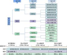
Fig. 3
Classification of ground substrates in the Southern Mountainous Regions"

Fig. 4
Classification of surface substrates in the Central Plains Region"

Tab. 3
Classification of ground substrates in the Northern Desert Area"
| 一级分类 | 二级分类 | 分类定义 | 三级分类 | 主要分布区域及海拔范围 | 主要植被类型 |
|---|---|---|---|---|---|
| 土质 | 初育土 | 土壤发育程度微弱,保持相对的幼年阶段,土壤剖面层次分异不明显 | 风沙土 | 分布于北部沙漠区,海拔约430~470 m | 梭梭、白梭梭、琵琶柴、碱蓬等植被 |

Fig. 5
Spatial distribution of mean NPPA values (a), and characteristics of different geomorphological subdivisions (b) of the Sangong River Basin"

Fig. 6
Typical profiles of key constraint layers of ground substrates at different elevations in the southern mountainous region"
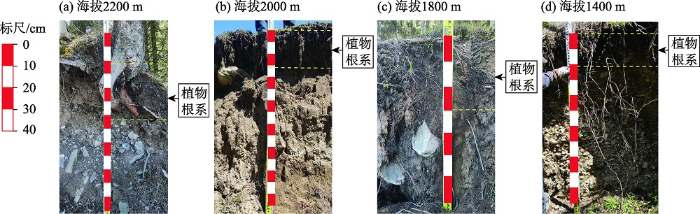
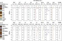
Fig. 7
Trends in the content of various ions and total salinity in S2 and S4 agricultural soil profiles"
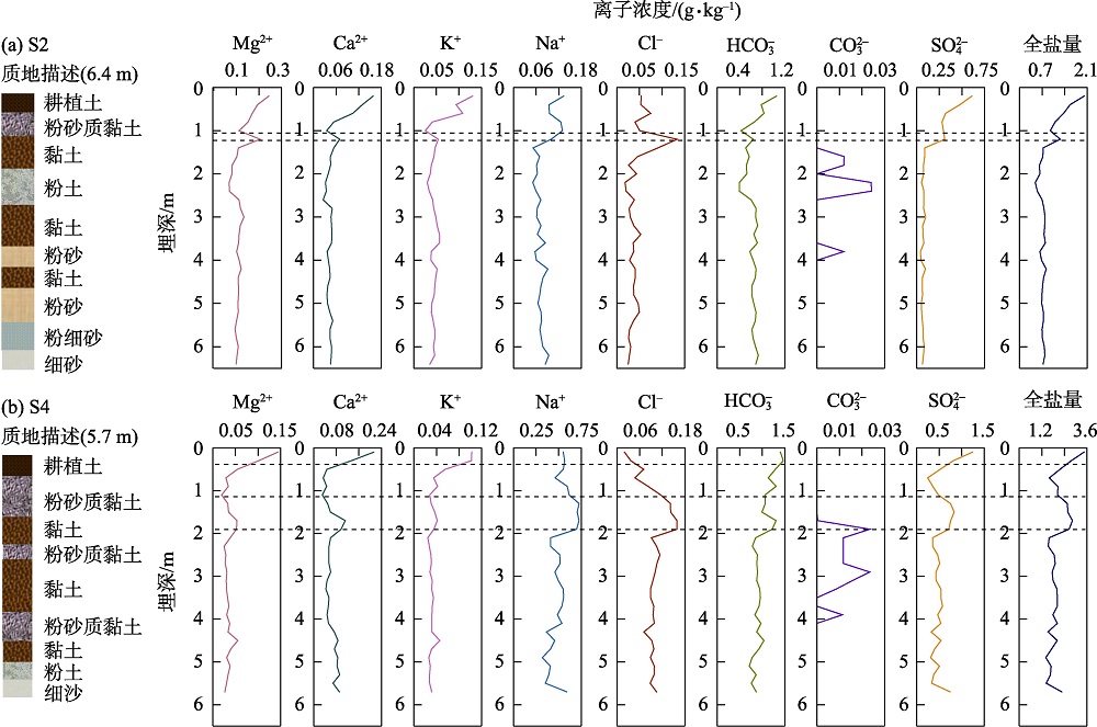

Fig. 8
Trends in the content of various ions and total salinity in S1 and S3 barren land soil profiles"


Fig. 9
Vertical in soil water content (a) and vertical distribution of plant absorbing root surface area (b-d) in the central plains region"

Fig. 10
Vertical distribution of root area of (a) Haloxylon ammodendron, and (b) Haloxylon persicum of the northern desert region"

| [1] | 自然资源部. 自然资源部办公厅关于印发《地表基质分类方案(试行)》的通知[EB/OL]. 2020, http://gi.mnr.gov.cn/202012/t20201222_2596025.html. |
| [ Ministry of Natural Resources. Notice of the General Office of the Ministry of Natural Resources Printing and Distributing the Ground Cover Layer Classification Scheme (Trial)[EB/OL]. 2020, http://gi.mnr.gov.cn/202012/t20201222_2596025.html. ] | |
| [2] | 侯红星, 张蜀冀, 鲁敏, 等. 自然资源地表基质层调查技术方法新经验——以保定地区地表基质层调查为例[J]. 西北地质, 2021, 54(3): 277-288. |
| [Hou Hongxing, Zhang Shuji, Lu Min, et al. New experience of the natural resources ground substrate layer survey technology method: Taking Baoding area ground substrate layer survey as an example[J]. Northwestern Geology, 2021, 54(3): 277-288. ] | |
| [3] | 殷志强, 陈自然, 李霞, 等. 地表基质综合调查:内涵、分层、填图与支撑目标[J]. 水文地质工程地质, 2023, 50(1): 144-151. |
| [Yin Zhiqiang, Chen Ziran, Li Xia, et al. Connotation, layering, mapping and supporting objectives of the integrated survey of ground substrates[J]. Hydrogeology & Engineering Geology, 2023, 50(1): 144-151. ] | |
| [4] | 孙禧勇, 许玮, 王明建. 地表基质层分层分类调查研究[J]. 中国土地, 2022(7): 34-36. |
| [Sun Xiyong, Xu Wei, Wang Mingjian. Investigative study on stratification and classification of surface substrates layers[J]. China Land, 2022(7): 34-36. ] | |
| [5] |
朱永官, 李刚, 张甘霖, 等. 土壤安全: 从地球关键带到生态系统服务[J]. 地理学报, 2015, 70(12): 1859-1869.
doi: 10.11821/dlxb201512001 |
| [Zhu Yongguan, Li Gang, Zhang Ganlin, et al. Soil security: From Earth’s critical zone to ecosystem services[J]. Acta Geographica Sinca, 2015, 70(12): 1859-1869. ] | |
| [6] | 殷志强, 秦小光, 张蜀冀, 等. 地表基质分类及调查初步研究[J]. 水文地质工程地质, 2020, 47(6): 8-14. |
| [Yin Zhiqiang, Qin Xiaoguang, Zhang Shuji, et al. Preliminary study on classification and investigation of surface substrate[J]. Hydrogeology and Engineering Geology, 2020, 47(6): 8-14. ] | |
| [7] | 葛良胜, 侯红星, 夏锐. 自然资源地表基质调查技术体系构建[J]. 地理信息世界, 2022, 29(5): 20-27. |
| [Ge Liangsheng, Hou Hongxing, Xia Rui. Construction of technical system for ground substrate survey of natural resources[J]. Geomatics World, 2022, 29(5): 20-27. ] | |
| [8] | 艾晓军, 陈占生, 耿国帅, 等. 辽阳—丹东地区黑土地地表基质有效土层分布规律及影响因素——以凤城市为例[J]. 河北农业科学, 2023, 27(3): 54-59, 65. |
| [Ai Xiaojun, Chen Zhansheng, Geng Guoshuai, et al. Distribution patterns and influencing factors of effective soil layers in the surface matrix of black soil in Liaoyang-dandong area—Taking Fengcheng city as an example[J]. Journal of Hebei Agricultural Sciences, 2023, 27(3): 54-59, 65. ] | |
| [9] | 霍东, 陈占生, 艾晓军, 等. 遥感解译在辽阳-丹东地区黑土地地表基质调查中的应用——以宽甸满族自治县为例[J]. 农业与技术, 2023, 43(15): 115-119. |
| [Huo Dong, Chen Zhansheng, Ai Xiaojun, et al. Application of remote sensing interpretation in surface substrate investigation of black soil in Liaoyang-dandong region: Taking Kuandian Manchu Autonomous County as an example[J]. Agriculture and Technology, 2023, 43(15): 115-119. ] | |
| [10] | 刘洪博, 孔繁鹏, 赵建, 等. 地表基质调查技术方法探索与实验——以黑龙江省宝清县黑土地调查为例[J]. 地理信息世界, 2022, 29(6): 1-5. |
| [Liu Hongbo, Kong Fanpeng, Zhao Jian, et al. Exploration and experiment of surface substrate investigation technique: A case study of black soil investigation in Baoqing County, Heilongjiang Province[J]. Geomatics World, 2022, 29(6): 1-5. ] | |
| [11] | 孙勇刚, 张闯, 尚晓雨, 等. 不同地表基质类型理化性质探索与研究——以河北塞罕坝示范区为例[J]. 资源信息与工程, 2023, 38(2): 13-16. |
| [Sun Yonggang, Zhang Chuang, Shang Xiaoyu, et al. Exploration and study on physiochemical properties of different ground substrate types: Taking the Saihanba demonstration area in Hebei Province as an example[J]. Resource Information and Engineering, 2023, 38(2): 13-16. ] | |
| [12] | 王根绪, 程国栋. 干旱荒漠绿洲景观空间格局及其受水资源条件的影响分析[J]. 生态学报, 2000, 20(3): 363-368. |
| [Wang Genxu, Cheng Guodong. The spatial pattern and influence caused by water resources in arid desert oases[J]. Acta Ecologica Sinica, 2000, 20(3): 363-368. ] | |
| [13] | 鲁如坤. 土壤农业化学分析方法[M]. 北京: 中国农业科技出版社, 2000. |
| [Lu Rukun. The Analysis Method of Soil Agricultural Chemistry[M]. Beijing: China Agricultural Science and Technology Press, 2000. ] | |
| [14] |
和清华, 谢云. 我国太阳总辐射气候学计算方法研究[J]. 自然资源学报, 2010, 25(2): 308-319.
doi: 10.11849/zrzyxb.2010.02.015 |
|
[He Qinghua, Xie Yun. Research on the climatological calculation method of solar radiation[J]. Journal of Natural Resources, 2010, 25(2): 308-319. ]
doi: 10.11849/zrzyxb.2010.02.015 |
|
| [15] | 栾海军, 邢宸硕, 张荣凯, 等. 基于Chen NDVI模型的NDVI尺度转换分形特性分析[J]. 遥感信息, 2022, 37(3): 12-20. |
| [Luan Haijun, Xing Chenshuo, Zhang Rongkai, et al. Analysis of fractal characteristics of NDVI scale conversion based on Chen NDVI model[J]. Remote Sensing Information, 2022, 37(3): 12-20. ] | |
| [16] | 朱文泉, 陈云浩, 徐丹, 等. 陆地植被净初级生产力计算模型研究进展[J]. 生态学杂志, 2005, 24(3): 296-300. |
| [Zhu Wenquan, Chen Yunhao, Xu Dan, et al. Advances in terrestrial net primary productivity (NPP) estimation models[J]. Chinese Journal of Ecology, 2005, 24(3): 296-300. ] | |
| [17] | 朱文泉, 潘耀忠, 龙中华, 等. 基于GIS和RS的区域陆地植被NPP估算——以中国内蒙古为例[J]. 遥感学报, 2005, 9(3): 300-307. |
| [Zhu Wenquan, Pan Yaozhong, Long Zhonghua, et al. Estimating net primary productivity of terrestrial vegetation based on GIS and RS: A case study in Inner Mongolia, China[J]. Journal of Remote Sensing, 2005, 9(3): 300-307. ] | |
| [18] | Yang H, Zhong X, Deng S, et al. Assessment of the impact of LUCC on NPP and its influencing factors in the Yangtze River basin, China[J]. Catena, 2021, 206: 105542. |
| [19] | Hu C, Zhang L, Wu Q, et al. Response of LUCC on runoff generation process in Middle Yellow River Basin: The Gushanchuan Basin[J]. Water, 2020, 12(5): 1237. |
| [20] | 尹小君, 祝宏辉, Gao Gerry, 等. 气候变化和人类活动对天山北坡净初级生产力变化的影响[J]. 农业工程学报, 2020, 36(20): 195-202. |
| [Yin Xiaojun, Zhu Honghui, Gao Jerry, et al. Effects of climate change and human activities on net primary productivity in the Northern Slope of Tianshan, Xinjiang, China[J]. Transactions of the Chinese Society of Agricultural Engineering, 2020, 36(20): 195-202. ] | |
| [21] | 陈炳铭, 赵善超, 孙丰华, 等. 气候变化和人类活动对干旱区垂直自然带NPP的影响[J]. 生态学杂志, 2023, 42(6): 1474-1483. |
|
[Chen Bingming, Zhao Shanchao, Sun Fenghua, et al. Impacts of climate change and human activities on the NPP of vertical natural belts in arid zones[J]. Chinese Journal of Ecology, 2023, 42(6): 1474-1483. ]
doi: DOI: 10.13292/j.1000-4890.202306.004 |
|
| [22] | 郝鑫怡, 张喆, 郑浩, 等. 天山北坡经济带植被覆盖度动态变化研究[J]. 中国环境科学, 2024, 44(2): 1020-1031. |
| [Hao Xinyi, Zhang Zhe, Zheng Hao, et al. Dynamic change of vegetation cover in the economic zone of the northern slopes of Tianshan Mountains[J]. China Environmental Science, 2024, 44(2): 1020-1031. ] | |
| [23] | 李艳忠, 罗格平, 许文强, 等. 天山北坡三工河流域中山带森林发育与气候土壤的关系[J]. 山地学报, 2011, 29(1): 33-42. |
| [Li Yanzhong, Luo Geping, Xu Wenqiang, et al. Forest development and their relationships with climatic and soil in the mid-mountain area of Sangong River watershed, northern slope of Tianshan Mountains[J]. Journal of Mountain Science, 2011, 29(1): 33-42. ] | |
| [24] |
田胜川, 赵善超, 郑新军, 等. 天山不同海拔雪岭云杉生长季水分来源[J]. 干旱区研究, 2023, 40(3): 436-444.
doi: 10.13866/j.azr.2023.03.10 |
|
[Tian Shengchuan, Zhao Shanchao, Zheng Xinjun, et al. Water source of spruce (Picea schrenkiana) at different altitudes in the Tianshan Mountains during the growing season[J]. Arid Zone Research, 2023, 40(3): 436-444. ]
doi: 10.13866/j.azr.2023.03.10 |
|
| [25] | 宋昕妮, 李路, 常亚鹏, 等. 天山北坡雪岭云杉林叶片-土壤氮磷化学计量特征[J]. 西北农林科技大学学报(自然科学版), 2020, 48(9): 97-104. |
| [Song Xinni, Li Lu, Chang Yapeng, et al. Stoichiometric characteristics of nitrogen and phosphorus in leaves and soils of Picea schrenk’s spruce forest on the northern slope of the Tianshan Mountains[J]. Journal of Northwest A & F University (Natural Science Edition), 2020, 48(9): 97-104. ] | |
| [26] |
龙威夷, 施建飞, 李双媛, 等. 流域绿洲土壤盐分多模型反演效果评估[J]. 干旱区研究, 2024, 41(7): 1120-1130.
doi: 10.13866/j.azr.2024.07.04 |
|
[Long Weiyi, Shi Jianfei, Li Shuangyuan, et al. Evaluation of multimodel inversion effects on soil salinity in oasis basin[J]. Arid Zone Research, 2024, 41(7): 1120-1130. ]
doi: 10.13866/j.azr.2024.07.04 |
|
| [27] | 孙芳强, 尹立河, 马洪云, 等. 准噶尔盆地南缘土壤水运移特征及其补给来源识别[J]. 干旱区研究, 2017, 34(6): 1271-1277. |
| [Sun Fangqiang, Yin Lihe, Ma Hongyun, et al. Identification of soil water migration and recharge sources in the southern marginal zone of the Junggar Basin China[J]. Arid Zone Research, 2017, 34(6): 1271-1277. ] | |
| [28] | 董雪, 李永华, 辛智鸣, 等. 唐古特白刺叶性状及叶片δ13C、δ15N沿降水梯度的变化特征[J]. 生态学报, 2019, 39(10): 3700-3709. |
| [Dong Xue, Li Yonghua, Xin Zhiming, et al. Variation in leaf traits and leaf δ13C and δ15N content in Nitraria tangutorum along precipitation gradient[J]. Acta Ecologica Sinica, 2019, 39(10): 3700-3709. ] | |
| [29] | 孙芳强, 尹立河, 王晓勇, 等. 新疆三工河流域厚层包气带区地下水垂向补给量的厘定[J]. 中国地质, 2017, 44(5): 913-923. |
| [Sun Fangqiang, Yin Lihe, Wang Xiaoyong, et al. Determination of vertical infiltration recharge of groundwater in the thick unsaturated zone of Sangong River Basin, Xinjiang[J]. Geology in China, 2017, 44(5): 913-923. ] | |
| [30] |
戴岳, 郑新军, 唐立松, 等. 古尔班通古特沙漠南缘梭梭水分利用动态[J]. 植物生态学报, 2014, 38(11): 1214-1225.
doi: 10.3724/SP.J.1258.2014.00117 |
|
[Dai Yue, Zheng Xinjun, Tang Lisong, et al. Dynamics of water usage in Haloxylon ammodendron in the southern edge of the Gurbantünggüt Desert[J]. Chinese Journal of Plant Ecology, 2014, 38(11): 1214-1225. ]
doi: 10.3724/SP.J.1258.2014.00117 |
|
| [31] | 徐贵青, 李彦. 共生条件下三种荒漠灌木的根系分布特征及其对降水的响应[J]. 生态学报, 2009, 29(1): 130-137. |
| [Xu Guiqing, Li Yan. Roots distribution of three desert shrubs and their response to precipitation under co-occurring conditions[J]. Acta Ecologica Sinica, 2009, 29(1): 130-137. ] | |
| [32] | Zeng J, Li Z, Chen Q, et al. Evaluation of remotely sensed and reanalysis soil moisture products over the Tibetan Plateau using in-situ observations[J]. Remote Sensing of Environment, 2015, 163: 91-110. |
| [33] | Luo M, Meng F, Sa C, et al. Response of vegetation phenology to soil moisture dynamics in the Mongolian Plateau[J]. Catena, 2021, 206: 105505. |
| [34] | 赵文智, 刘鹄. 荒漠区植被对地下水埋深响应研究进展[J]. 生态学报, 2006, 26(8): 2702-2708. |
| [Zhao Wenzhi, Liu Hu. Recent advances in desert vegetation response to groundwater table changes[J]. Acta Ecologica Sinica, 2006, 26(8): 2702-2708. ] | |
| [35] |
徐海量, 宋郁东, 王强, 等. 塔里木河中下游地区不同地下水位对植被的影响[J]. 植物生态学报, 2004, 28(3): 400-405.
doi: 10.17521/cjpe.2004.0057 |
|
[Xu Hailiang, Song Yudong, Wang Qiang, et al. The effect of groundwater level on vegetation in the middle and lower reaches of the Tarim River, Xinjiang, China[J]. Chinese Journal of Plant Ecology, 2004, 28(3): 400-405. ]
doi: 10.17521/cjpe.2004.0057 |
| [1] | LYU Zhuangzhuang, QIAO Qingqing, DONG Sunyi, WANG Dong. Paleoclimatic evolution and driving mechanisms in arid areas of inland Asia during the Middle Miocene Climatic Optimum in the context of global climate warming [J]. Arid Zone Research, 2024, 41(8): 1309-1322. |
| [2] | WANG Yiwen, MA Yaoyao, SHI Peijun, ZHANG Gangfeng. The impact of photovoltaic power plant operation on local ecological environments in arid areas [J]. Arid Zone Research, 2024, 41(8): 1423-1433. |
| [3] | LONG Weiyi, SHI Jianfei, LI Shuangyuan, SUN Jinjin, WANG Yugang. Evaluation of multimodel inversion effects on soil salinity in oasis basin [J]. Arid Zone Research, 2024, 41(7): 1120-1130. |
| [4] | YE Hu, PEI Hao, JIANG Yanfeng, NA Qing, ZHANG Liwei. Properties of aerosol scattering and its influencing factors in semiarid areas of Inner Mongolia [J]. Arid Zone Research, 2024, 41(5): 730-741. |
| [5] | YUAN Ping, HAN Huan, ZHAO Hongmei, LI Congjuan. Effects of bare versus sand burial on the decomposition and nutrient release of apophyges in extremely arid zones [J]. Arid Zone Research, 2024, 41(2): 293-300. |
| [6] | WANG Xiang, LYU Haishen, ZHU Yonghua, GUO Chenyu. Application and comparison of two channel flood routing methods in Xinjiang mountainous areas [J]. Arid Zone Research, 2023, 40(8): 1240-1247. |
| [7] | LU Yuanbo, YAN Cheng, SONG Chunwu, LI Yajuan, LAI Zhaoyun. Response of plant community distribution in the pre-montane desert grassland on the southern slope of Tianshan Mountain to environmental factors: A case study in Baicheng County [J]. Arid Zone Research, 2023, 40(8): 1346-1357. |
| [8] | MENG Na, ZHANG Ying. Identification of priority areas for forest land expansion in Shanxi Province [J]. Arid Zone Research, 2023, 40(1): 111-122. |
| [9] | PANG Haiwei,YU Dian,REN Chengbao,ZHANG Yu,ZHENG Caizhi,GUO Jiacheng,BIAN Zhen,SANG Guoqing. Remote sensing classification characteristics of typical plant communities in the semi-arid areas of eastern Ningxia [J]. Arid Zone Research, 2022, 39(6): 1930-1941. |
| [10] | LUO Chengyan,CHEN Fulong,HE Chaofei,LONG Aihua,QIAO Changlu. Applicability of CMADS in runoff simulation of Yulong Kashi River [J]. Arid Zone Research, 2022, 39(4): 1090-1101. |
| [11] | LU Fangyuan,JIA Debin,GAO Ruizhong,SU Wenxu,ZHAO Hang,YANG Li’na. Dynamic simulation and carrying capacity analysis of a water resource system in Kubuqi Desert [J]. Arid Zone Research, 2022, 39(4): 1102-1111. |
| [12] | BAI Jianduo,PENG Jie,SHI Zhou,WANG Yuzhen,LIU Weiyang,LI Hongyi. Precise management zoning in arid soil croplands based on multi-source data [J]. Arid Zone Research, 2022, 39(2): 646-655. |
| [13] | WANG Xuyang,LI Dianpeng,SUN Tao,SUN Xia,JIA Hongtao,LI Jun,LI Xinhu. Effects of soil mulching on the greenhouse gas emissions of crops farmland in an arid area of Xinjiang [J]. Arid Zone Research, 2022, 39(1): 176-184. |
| [14] | YAN Xinyang,ZHANG Qiang,ZHANG Wenbo,REN Xueyuan,WANG Sheng,ZHAO Funian. Analysis of climate characteristics in the Pan-Central-Asia arid region [J]. Arid Zone Research, 2021, 38(1): 1-11. |
| [15] | CAO Guo-liang, LI Tian-chen, LU Chui-yu, XU Zhi-xia. Dynamic variation and evaporation of seasonal lakes in arid areas:A case study for the Aiding Lake [J]. Arid Zone Research, 2020, 37(5): 1095-1104. |
|
||