Arid Zone Research ›› 2021, Vol. 38 ›› Issue (5): 1484-1496.doi: 10.13866/j.azr.2021.05.31
• Ecology and Environment • Previous Articles
Pariha Helili1,2( ),ZAN Mei1,2(),Alimjan Kasim1,2
Received:2021-01-26
Revised:2021-07-05
Online:2021-09-15
Published:2021-09-24
Contact:
Mei ZAN
E-mail:1601250145@qq.com;zanmei1102@163.com
Pariha Helili,ZAN Mei,Alimjan Kasim. Remote sensing evaluation of ecological environment in Urumqi City and analysis of driving factors[J].Arid Zone Research, 2021, 38(5): 1484-1496.
Add to citation manager EndNote|Reference Manager|ProCite|BibTeX|RefWorks
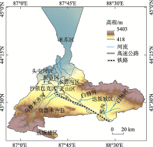
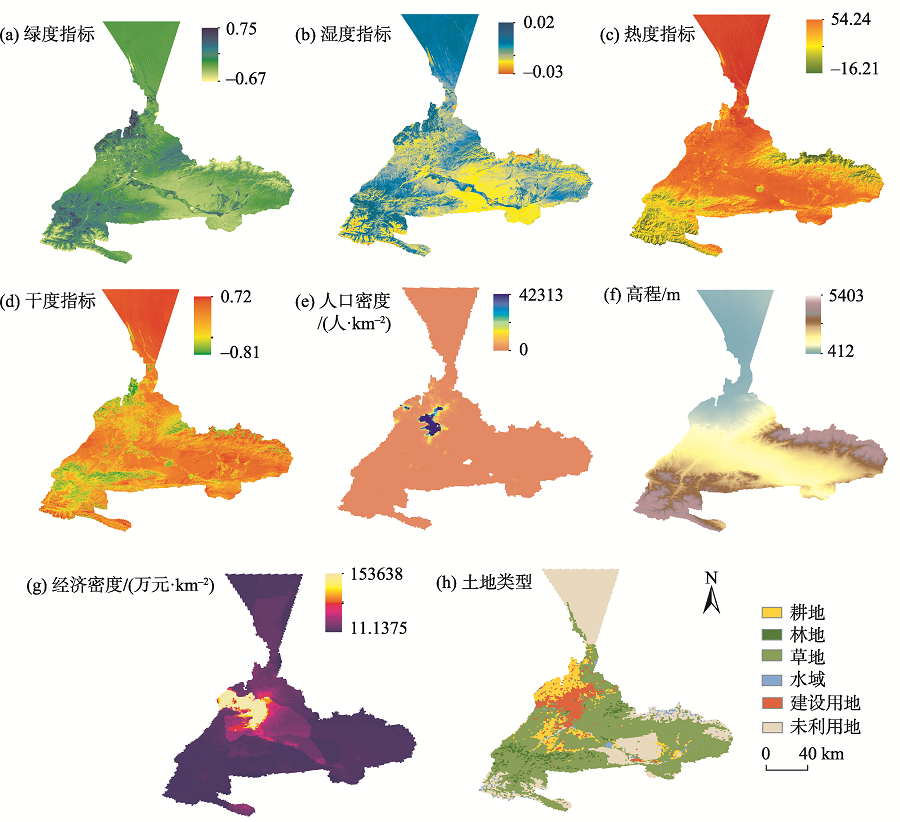
Fig. 1
Location map of the study area"

Tab. 1
Principal component analysis of remote sensing ecological index"
| 主成分 | 2000年 | 2010年 | 2019年 | |||
|---|---|---|---|---|---|---|
| 特征值 | 贡献率/% | 特征值 | 贡献率/% | 特征值 | 贡献率/% | |
| PC1 | 0.1475 | 82.69 | 0.0629 | 89.02 | 0.0622 | 88.71 |
| PC2 | 0.0276 | 11.68 | 0.0062 | 7.89 | 0.0057 | 5.47 |
| PC3 | 0.0025 | 4.56 | 0.0013 | 2.61 | 0.0032 | 4.43 |
| PC4 | 0.0008 | 1.13 | 0.0002 | 0.48 | 0.0004 | 1.13 |
Tab. 2
Change of 4 indicators and RSEI in each year in Urumqi City"
| 年份 | 统计值 | NDVI | WET | LST | NDBSI | RSEI |
|---|---|---|---|---|---|---|
| 2000 | 最小值 | -1.00 | -0.02 | -20.78 | -0.90 | 0.00 |
| 最大值 | 1.00 | 0.02 | 63.64 | 0.37 | 1.00 | |
| 均值 | -0.02 | 0.01 | 8.93 | 0.02 | 0.21 | |
| 标准差 | 0.06 | 0.00 | 13.86 | 0.09 | 0.30 | |
| 2010 | 最小值 | -0.76 | -0.03 | -18.48 | -0.82 | 0.00 |
| 最大值 | 0.52 | 0.02 | 54.31 | 0.50 | 1.00 | |
| 均值 | -0.03 | 0.00 | 10.07 | 0.02 | 0.21 | |
| 标准差 | 0.10 | 0.00 | 17.25 | 0.07 | 0.32 | |
| 2019 | 最小值 | -1.00 | -0.03 | -16.21 | -0.81 | 0.00 |
| 最大值 | 0.60 | 0.02 | 54.24 | 0.72 | 1.00 | |
| 均值 | 0.03 | 0.01 | 8.87 | -0.11 | 0.23 | |
| 标准差 | 0.06 | 0.09 | 15.20 | 0.18 | 0.33 |

Fig. 2
Spatial distribution remote sensing ecological index value classes in Urumqi City"
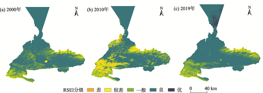
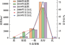
Fig. 3
Statistical chart of ecological grades and area rations in each years"

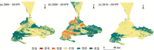
Fig. 4
Change detection diagram of RSEI in Urumqi City from 2000 to 2019"

Tab. 3
Detection of the change of RSEI level in Urumqi City from 2000 to 2019"
| 变化 | 2000—2010年 | 2010—2019年 | 2000—2019年 | |||
|---|---|---|---|---|---|---|
| 面积/km2 | 占比/% | 面积/km2 | 占比/% | 面积/km2 | 占比/% | |
| 恶化 | 0.001 | 0.00 | 0.00 | 0.00 | 0 | 0.00 |
| 变差 | 156.37 | 1.14 | 1104.65 | 8.03 | 56.91 | 0.41 |
| 不变 | 9058.09 | 65.75 | 7184.73 | 52.21 | 10621 | 77.10 |
| 变好 | 4435.82 | 32.20 | 5470.91 | 39.76 | 3097.87 | 22.49 |
| 优化 | 125.88 | 0.91 | 0.02 | 0.00 | 0.37 | 0.00 |

Fig. 5
Risk detection and interactive detection matrix"
Tab. 4
The results of single detection"
| 探测因子 | 2000年 | 2010年 | 2019年 | ||||||
|---|---|---|---|---|---|---|---|---|---|
| q值 | P值 | q排序 | q值 | P值 | q排序 | q值 | P值 | q排序 | |
| 绿度指标 | 0.179 | 0 | 7 | 0.349 | 0 | 3 | 0.095 | 0 | 5 |
| 湿度指标 | 0.526 | 0 | 2 | 0.168 | 0 | 6 | 0.326 | 0 | 3 |
| 热度指标 | 0.857 | 0 | 1 | 0.706 | 0 | 1 | 0.653 | 0 | 1 |
| 干度指标 | 0.252 | 0 | 4 | 0.368 | 0 | 2 | 0.046 | 0 | 8 |
| 人口密度 | 0.07 | 1 | 8 | 0.067 | 0 | 8 | 0.166 | 0 | 4 |
| 土地利用 | 0.235 | 0 | 5 | 0.077 | 0 | 7 | 0.091 | 0 | 6 |
| 海拔 | 0.2 | 0 | 6 | 0.345 | 0 | 4 | 0.52 | 0 | 2 |
| 经济密度 | 0.263 | 0 | 3 | 0.199 | 0 | 5 | 0.072 | 0 | 7 |
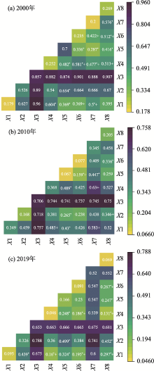
Fig. 6
Interactive detector results"

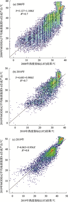
Fig. 7
Comparison of LST results with MODIS surface temperature products in 2000、2010 and 2019"

Tab. 5
Combination of detection factors"
| 年份 | 交互因子 | q(X1∩X2) | q(X1)+q(X2) | C | 影响模式 |
|---|---|---|---|---|---|
| 2000 | NDVI∩NDBSI | 0.604 | 0.431 | 0.173 | 非线性增强 |
| 人口密度∩NDBSI | 0.482 | 0.322 | 0.160 | 非线性增强 | |
| 人口密度∩NDVI | 0.369 | 0.249 | 0.120 | 非线性增强 | |
| DEM∩经济密度 | 0.576 | 0.463 | 0.113 | 非线性增强 | |
| 2010 | 土地利用∩经济密度 | 0.336 | 0.276 | 0.060 | 非线性增强 |
| 人口密度∩NDBSI | 0.489 | 0.435 | 0.054 | 非线性增强 | |
| 人口密度∩WET | 0.265 | 0.235 | 0.030 | 非线性增强 | |
| 人口密度∩NDVI | 0.430 | 0.416 | 0.014 | 非线性增强 | |
| 2019 | 人口密度∩NDVI | 0.324 | 0.261 | 0.063 | 非线性增强 |
| 人口密度∩NDBSI | 0.248 | 0.212 | 0.036 | 非线性增强 | |
| NDVI∩WET | 0.439 | 0.421 | 0.018 | 非线性增强 | |
| 人口密度∩经济密度 | 0.247 | 0.238 | 0.009 | 非线性增强 |
| [1] | 王东升, 王小磊, 雷泽勇. 基于遥感生态指数的阜新市生态质量评估[J]. 生态科学, 2020, 39(3): 88-94. |
| [ Wang Dongsheng, Wang Xiaolei, Lei Zeyong. Ecological change assessment of Fuxin based on remote sensing ecological index[J]. Ecological Science, 2020, 39(3): 88-94. ] | |
| [2] |
杨江燕, 吴田, 潘肖燕, 等. 基于遥感生态指数的雄安新区生态质量评估[J]. 应用生态学报, 2019, 30(1): 277-284.
doi: 10.13287/j.1001-9332.201901.017 pmid: 30907550 |
|
[ Yang Jiangyan, Wu Tian, Pan Xiaoyan, et al. Ecological quality assessment of Xiongan New Area based on remote sensing ecological index[J]. Chinese Journal of Applied Ecology, 2019, 30(1) : 277-284. ]
doi: 10.13287/j.1001-9332.201901.017 pmid: 30907550 |
|
| [3] | 宋媛, 石惠春, 谢敏慧, 等. 2000—2017年甘肃省生态环境质量时空演变格局及其影响因素[J]. 生态学杂志, 2019, 38(12): 3800-3808. |
| [ Song Yuan, Shi Huichun, Xie Minhui, et al. Spatiotemporal evolution pattern and influencing factors of eco-environmental quality in Gansu from 2000 to 2017[J]. Chinese Journal of Ecology, 2019, 38(12): 3800-3808. ] | |
| [4] | 杨胜天, 刘昌明, 杨志峰, 等. 南水北调西线调水工程区的自然生态环境评价[J]. 地理学报, 2002, 57(1): 11-18. |
| [ Yang Shengtian, Liu Changming, Yang Zhifeng, et al. Natural Eco-environmental evaluation of west route area of interbasin water transfer project[J]. Acta Geographic Sinica, 2002, 57(1): 11-18. ] | |
| [5] | 任志远, 李晶. 陕南秦巴山区植被生态功能的价值测评[J]. 地理学报, 2003, 58(4): 503-511. |
| [ Ren Zhiyuan, Li Jing. The valuation of ecological services from the vegetation ecosystems in the Qinling-Daba mountains[J]. Acta Geographic Sinica, 2003, 58(4): 503-511. ] | |
| [6] | 李晓文, 方精云, 朴世龙. 近10年来长江下游土地利用变化及其生态环境效应[J]. 地理学报, 2003, 58(5): 659-667. |
| [ Li Xiaowen, Fang Jingyun, Piao Shilong. Landuse changes and its implication to the ecological consequences in lower Yangze region[J]. Acta Geographic Sinica, 2003, 58(5): 659-667. ] | |
| [7] | 阿里木江·卡斯木. 人口密度、夜间光数据及MODIS的全球城市分类[J]. 遥感信息, 2018, 33(1): 86-92. |
| [ Alimujiang Kasimu. Global urban characterization using population density, DMSP data and MODIS data[J]. Remote Sensing Information, 2018, 33(1): 86-92. ] | |
| [8] | 高炜, 安如, 王喆. 基于微波遥感技术的干旱监测指数及其应用研究——以三江源区为例[J]. 干旱区研究, 2017, 34(3): 541-550. |
| [ Gao Wei, An Ru, Wang Zhe. Drought index and its application based on microwave remote sensing technology: A case study in the Three-River Headwaters Region[J]. Arid Zone Research, 2017, 34(3): 541-550. ] | |
| [9] |
Sullivan C A, Skeffington M S, Gormally M J, et al. The ecological status of grasslands on lowland farmlands in western Ireland and implications for grassland classification and nature value assessment[J]. Biological Conservation, 2010, 143: 1529-1539.
doi: 10.1016/j.biocon.2010.03.035 |
| [10] | Li Wangming, Wang Jianzheng, Ge Dandong. Analysis of ecological carrying capacity change and driving factors at urban fringe: A case of Hangzhou City[J]. Journal of Zhejiang University(Engineering Science), 2008, 42(1): 39-43. |
| [11] |
Ochoa-Gaona S, Kampichler C, de Jong B H J, et al. Amulti-criterion index for the evaluation of local tropical forest conditions in Mexico[J]. Forest Ecology Management, 2010, 260: 618-627.
doi: 10.1016/j.foreco.2010.05.018 |
| [12] |
阿布都米吉提·阿布力克木, 阿里木江·卡斯木, 艾里西尔·库尔班, 等. 近40年台特玛-康拉克湖泊群水域变化遥感监测[J]. 湖泊科学, 2014, 26(1): 46-54.
doi: 10.18307/2014.0106 |
|
[ Ablekim Abdimijit, Kasimu Alimujiang, Kurban Alishir, et al. Monitoring the water area changes in Tetima-Kanglayka lakes region over the past four decades by remotely sensed data[J]. Journal of Lake Sciences, 2014, 26(1): 46-54. ]
doi: 10.18307/2014.0106 |
|
| [13] |
张瑞钢, 莫兴国, 林忠辉. 滹沱河上游山区近50年蒸散变化及主要影响因子分析[J]. 地理科学, 2012, 32(5): 628-634.
doi: 10.13249/j.cnki.sgs.2012.05.628 |
|
[ Zhang Ruigang, Mo Xingguo, Lin Zhonghui. The trend and the principal influence factors of evapotranspiration in Hutuo River Basin during last 50 years[J]. Scientia Geographica Sinica, 2012, 32(5): 628-634. ]
doi: 10.13249/j.cnki.sgs.2012.05.628 |
|
| [14] | 李佩武, 李贵才, 陈莉, 等. 深圳市植被径流调节及其生态效益分析[J]. 自然资源学报, 2009, 24(7): 1223-1233. |
| [ Li Peiwu, Li Guicai, Chen Li, et al. Analysis of Shenzhen’s vegetation: Flood control and ecological benefit[J]. Journal of Natural Resources, 2009, 24(7): 1223-1233. ] | |
| [15] | 崔秋洋, 潘云, 杨雪. 基于Landsat 8遥感影像的北京市平原区不透水层盖度估算[J]. 首都师范大学学报(自然科学版), 2015, 36(2): 89-92. |
| [ Cui Qiuyang, Pan Yun, Yang Xue. Estimation of the impermeable layer coverage in the plain area of Beijing based on Landsat 8 remote sensing image[J]. Journal of Capital Normal University(Natural Science Edition), 2015, 36(2): 89-92. ] | |
| [16] | 徐涵秋. 区域生态环境变化的遥感评价指数[J]. 中国环境科学, 2013, 33(5): 889-897. |
| [ Xu Hanqiu. A remote sensing index for assessment of regional ecological changes[J]. China Environmental Science, 2013, 33(5): 889-897. ] | |
| [17] | 张亚球, 姜放, 纪梦达, 等. 基于遥感指数的区县级生态环境评价[J]. 干旱区研究, 2020, 37(6): 1598-1605. |
| [ Zhang Yaqiu, Jiang Fang, Ji Mengda, et al. Assessment of the ecological environment at district and county level based on remote sensing index[J]. Arid Zone Research, 2020, 37(6): 1598-1605. ] | |
| [18] |
王劲峰, 徐成东. 地理探测器: 原理与展望[J]. 地理学报, 2017, 72(1): 116-134.
doi: 10.11821/dlxb201701010 |
|
[ Wang Jinfeng, Xu Chengdong. Geodetector: Principle and prospective[J]. Acta Geographic Sinica, 2017, 72(1): 116-134. ]
doi: 10.11821/dlxb201701010 |
|
| [19] | 郭泽呈, 魏伟, 庞素菲, 等. 基于SPCA和遥感指数的干旱内陆河流域生态脆弱性时空演变及动因分析——以石羊河流域为例[J]. 生态学报, 2019, 39(7): 2558-2572. |
| [ Guo Zecheng, Pang Sufei, et al. Spatio-temporal evolution and motivation analysis of ecological vulnerability in Arid Inland River Basin based on SPCA and remote sensing index: A case study on the Shiyang River Basin[J]. Acta Ecologica Sinica, 2019, 39(7): 2558-2572. ] | |
| [20] | 文广超, 赵梅娟, 谢洪波, 等. 伊犁河谷西部土地植被覆盖演化及驱动力分析[J]. 干旱区研究, 2021, 38(3): 843-854. |
| [ Wan Guangchao, Zhao Meijuan, Xie Hongbo, et al. Analysis of land vegetation cover evolution and driving forces in the western part of the Ili River Valley[J]. Arid Zone Research, 2021, 38(3): 843-854. ] | |
| [21] | 张亚如, 张军民. 城镇化与经济发展的时空相互作用机制研究——以新疆为例[J]. 干旱区地理, 2020, 43(3): 839-848. |
| [ Zhang Yaru, Zhang Junmin. Spatio-temporal interaction mechanism of urbanization and economic development: A case of Xinjiang[J]. Arid Land Geography, 2020, 43(3): 839-848. ] | |
| [22] | 李世海. 乌鲁木齐市大气环境质量现状及对策[J]. 区域治理, 2019(24): 54-57. |
| [ Li Shihai. Present situation and countermeasure of atmospheric environment quality in Urumqi[J]. Regional Governance, 2019(24): 54-57. ] | |
| [23] | 魏伟, 颉耀文, 魏晓旭, 等. 基于CLUE-S模型和生态安全格局的石羊河流域土地利用优化配置[J]. 武汉大学学报(信息科学版), 2017, 42(9): 1306-1315. |
| [ Xie Yaowen, Wei Xiaoxu, et al. Land use optimization based on CLUE-S model and ecological security scenario in Shiyang river basin[J]. Geomatics and Information Science of Wuhan University, 2017, 42(9): 1306-1315. ] | |
| [24] | Liu H, Jiang D, Yang X, et al. Spatialization approach to 1 km grid GDP supported by remote sensing[J]. Geo-Information Science, 2005, 7(2): 120-123. |
| [25] | 易玲, 熊利亚, 杨小唤. 基于GIS技术的GDP空间化处理方法[J]. 甘肃科学学报, 2006, 18(2): 54-58. |
| [ Yi Ling, Xiong Liya, Yang Xiaohuan. Method of Pixelizing GDP data based on the GIS[J]. Journal of Gansu Sciences, 2006, 18(2): 54-58. ] | |
| [26] | 王志杰, 苏嫄. 南水北调中线汉中市水源地生态脆弱性评价与特征分析[J]. 生态学报, 2018, 38(2): 432-442. |
| [ Wang Zhijie, Su Yuan. Analysis of eco-environmental vulnerability characteristics of Hanzhong City, near the water source midway along the route of the south-to-north water transfer project, China[J]. Acta Ecologica Sinica, 2018, 38(2): 432-442. ] | |
| [27] | 徐涵秋. 城市遥感生态指数的创建及其应用[J]. 生态学报, 2013, 33(24): 7853-7862. |
| [ Xu Hanqiu. A remote sensing urban ecological index and its application[J]. Acta Ecologica Sinica, 2013, 33(24): 7853-7862. ] | |
| [28] | 王丽春, 焦黎, 来风兵, 等. 基于遥感生态指数的新疆玛纳斯湖湿地生态变化评价[J]. 生态学报, 2019, 39(8): 2963-2972. |
| [ Wang Lichun, Jiao Li, Lai Fengbin, et al. Evaluation of ecological changes based on a remote sensing ecological index in a Manas Lake wetland, Xinjiang[J]. Acta Ecologica Sinica, 2019, 39(8): 2963-2972. ] | |
| [29] |
Huang C, Wylie B, Yang L, et al. Derivation of a tasselled cap transformation based on Landsat 7 at satellite reflectance[J]. International Journal of Remote Sensing, 2002, 23(6): 1741-1748.
doi: 10.1080/01431160110106113 |
| [30] | 徐涵秋. 水土流失区生态变化的遥感评估[J]. 农业工程学报, 2013, 29(7): 91-97, 294. |
| [ Xu Hanqiu. Remote sensing assessment of ecological changes in soil and water loss areas[J]. Transactions of the Chinese Society of Agricultural Engineering, 2013, 29(7): 91-97, 294. ] | |
| [31] |
Nichol J. Remote sensing of urban heat islands by day and night[J]. Photogrammetric Engineering and Remote Sensing, 2005, 71(6): 613-621.
doi: 10.14358/PERS.71.5.613 |
| [32] | 蒋博文. 基于PCA变换的多光谱图像降维方法研究[J]. 信息技术, 2012, 36(8): 98-101. |
| [ Jiang Bowen. Method of multi-spectral images reduce-dimensions based on PCA[J]. Information Technology, 2012, 36(8): 98-101. ] | |
| [33] | 王静, 姚顺波, 刘天军. 退耕还林(草)工程实施以来降水利用效率演变格局及归因——以宝鸡地区为例[J]. 干旱区研究, 2020, 37(5): 1233-1245. |
| [ Wang Jing, Yao Shunbo, Liu Tianjun. The evolution pattern and attribution of rainfall use efficiency since the implementation of the project of returning farmland to forest (grass): A case study in Baoji[J]. Arid Zone Research, 2020, 37(5): 1233-1245. ] | |
| [34] | 朱增云, 阿里木江·卡斯木. 基于地理探测器的伊犁谷地生境质量时空演变及其影响因素[J]. 生态学杂志, 2020, 39(10): 3408-3420. |
| [ Zhu Zengyun, Alimujiang Kasimu. Spatial-temporal evolution of habital quality in Yili Valley based on geographical detectors and its influencing factors[J]. Chinese Journal of Ecology, 2020, 39(10): 3408-3420. ] | |
| [35] | 高鹏文, 阿里木江·卡斯木, 图尔荪阿依·如孜, 等. 哈密市生态环境效益时空分析[J]. 干旱区研究, 2020, 37(4): 1057-1067. |
| [ Gao Pengwen, Alimujiang Kasimu, Tursunayi Ruzi, et al. Temporal and spatial analysis of ecological environment improvement in Hami City[J]. Arid Zone Research, 2020, 37(4): 1057-1067. ] | |
| [36] | 杨保华, 杨清华, 陈剑虹. 关于《生态环境状况评价技术规范(试行)》中土地退化指数的权重及计算方法的探讨[J]. 生态与农村环境学报, 2011, 27(3): 103-107. |
| [ Yang Baohua, Yang Qinghua, Chen Jianhong. Weight of land (soil) degradation indeces and optimization of their calculation in “echnical criteria or evaluation of ecological environment (Trial)”[J]Journal of Ecology and Rural environment, 2011, 27(3): 103-107. ] | |
| [37] | 蔡贤, 杜晓初. 基于遥感生态指数的鄂州市生态环境质量评估[J]. 湖北大学学报(自然科学版), 2020, 42(3): 233-239, 246. |
| [ Cai Xian, Du Xiaochu. Eco-environment quality assessment of Ezhou City based on RSEI[J]. Journal of Hubei University (Natural Science Edition), 2020, 42(3): 233-239, 246. ] | |
| [38] | 孙灏, 马立茹, 蔡创创, 等. 干旱区地表温度和热岛效应演变研究——以宁夏沿黄城市带为例[J]. 干旱区地理, 2020, 43(3): 694-705. |
| [ Sun Hao, Ma Liru, Cai Chuangchuang, et al. Evolution of surface temperature and heat island effect in arid areas: A case of city belt along the Yellow River in Ningxia[J]. Arid Land Geography, 2020, 43(3): 694-705. ] | |
| [39] | 高焕霖, 张廷龙, 樊华烨, 等. 基于地理探测器的杨凌示范区生态环境质量影响因素定量分析[J]. 西北林学院学报, 2020, 35(5): 185-194. |
| [ Gao Huanlin, Zhang Tinglong, Fan Huaye, et al. Quantitative analysis of the factors affecting ecological environment quality in Yangling demonstration zone based on geograohical detector[J]. Journal of Northwest Forestry University, 2020, 35(5): 185-194. ] | |
| [40] |
宋慧敏, 薛亮. 基于遥感生态指数模型的渭南市生态环境质量动态监测与分析[J]. 应用生态学报, 2016, 27(12): 3913-3919.
doi: 10.13287/j.1001-9332.201612.024 pmid: 29704350 |
|
[ Song Huimin, Xue Liang. Dynamic monitoring and analysis of ecological environment in Weinan City, Northwest China based on RSEI model[J]. Chinese Journal of Applied Ecology, 2016, 27(12): 3913-3919. ]
doi: 10.13287/j.1001-9332.201612.024 pmid: 29704350 |
|
| [41] | Song Y, Wang J, Ge Y, et al. An optimal parameters-based geographical detector model enhances geographic characteristics of explanatory variables for spatial heterogeneity analysis: Cases with different types of spatial data[J]GIScience & Remote Sensing, 2020, 5: 593-610. |
|
||