Arid Zone Research ›› 2022, Vol. 39 ›› Issue (3): 774-786.doi: 10.13866/j.azr.2022.03.11
Previous Articles Next Articles
WEN Guangchao( ),LI Xing,WU Bingjie,WANG Xiaohe,XIE Hongbo
Received:2021-08-30
Revised:2021-10-06
Online:2022-05-15
Published:2022-05-30
WEN Guangchao,LI Xing,WU Bingjie,WANG Xiaohe,XIE Hongbo. An automatic method for delineating lake surfaces in Qaidam Basin using Landsat images[J].Arid Zone Research, 2022, 39(3): 774-786.
Add to citation manager EndNote|Reference Manager|ProCite|BibTeX|RefWorks
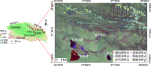
Fig. 1
Location of the study area and the distribution of sampling points"

Tab. 1
Basic information of some remote sensing images used"
| 地区 | 传感器 | 日期/年-月-日 | 条带号 | 行号 | 云量/% |
|---|---|---|---|---|---|
| 可鲁克湖 | TM | 2000-04-10 | 135 | 34 | 13.45 |
| 可鲁克湖 | ETM+ | 2002-04-08 | 135 | 34 | 3 |
| 可鲁克湖 | OLI | 2016-07-27 | 135 | 34 | 2.36 |
| 小柴旦湖 | TM | 2004-06-15 | 136 | 34 | 0.79 |
| 尕斯库勒湖 | TM | 2002-05-14 | 139 | 34 | 14.42 |
| 青海湖 | OLI | 2018-07-19 | 133 | 34 | 20.49 |
| 察尔汗盐湖 | OLI | 2020-04-08 | 136 | 34 | 6.88 |
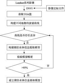
Fig. 2
Technical route for establishing lake water body information extraction model"


Fig. 3
Spectral signatures of six major land use classes in the study area"
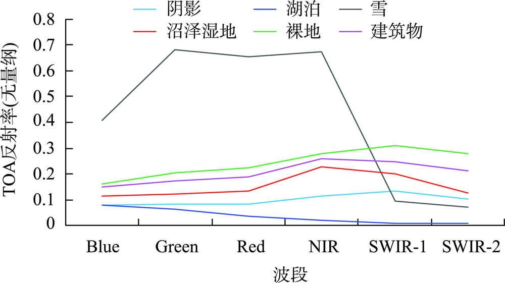
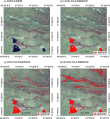
Fig. 4
Results of lake water extraction in Keluke Lake"

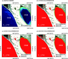
Fig. 5
Results of lake water extraction in Qinghai Lake"


Fig. 6
Results of lake water extraction by LWDM in Qinghai Lake"
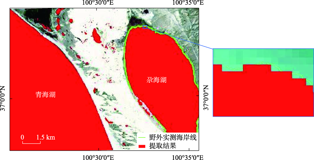
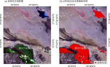
Fig. 7
Results of lake water extraction by LWDM in Chaerhan Salt Lake"

Tab. 2
Evaluation result of information extraction accuracy of lake water"
| 试验区域 | 传感器 | 成像时间/年-月-日 | 方法 | OA/% | Kappa | 用户精度/% |
|---|---|---|---|---|---|---|
| 可鲁克湖 | TM | 2000-04-10 | LWDM | 99.65 | 0.9958 | 99.39 |
| 可鲁克湖 | ETM+ | 2002-04-08 | 99.43 | 0.9932 | 100 | |
| 可鲁克湖 | OLI | 2016-07-27 | 99.87 | 0.9987 | 99.47 | |
| 小柴旦湖 | TM | 2004-06-15 | 99.65 | 0.9948 | 100 | |
| 尕斯库勒湖 | TM | 2002-05-14 | 99.91 | 0.9988 | 99.65 | |
| 青海湖 | OLI | 2018-07-19 | 99.87 | 0.9984 | 99.20 | |
| 察尔汗盐湖 | OLI | 2020-04-08 | 97.98 | 0.9339 | 99.94 | |
| 平均值 | 99.48 | 0.9877 | 99.66 | |||
| 可鲁克湖 | TM | 2000-04-10 | NDWI | 95.42 | 0.9450 | 79.12 |
| 可鲁克湖 | ETM+ | 2002-04-08 | 95.07 | 0.9409 | 77.18 | |
| 可鲁克湖 | OLI | 2016-07-27 | 97.83 | 0.9728 | 90.20 | |
| 小柴旦湖 | TM | 2004-06-15 | 95.60 | 0.9340 | 88.34 | |
| 尕斯库勒湖 | TM | 2002-05-14 | 96.38 | 0.9517 | 87.34 | |
| 青海湖 | OLI | 2018-07-19 | 99.63 | 0.9956 | 97.84 | |
| 察尔汗盐湖 | OLI | 2020-04-08 | 96.27 | 0.7363 | 99.89 | |
| 平均值 | 96.60 | 0.9252 | 88.56 | |||
| 可鲁克湖 | TM | 2000-04-10 | MNDWI | 77.67 | 0.7320 | 42.74 |
| 可鲁克湖 | ETM+ | 2002-04-08 | 64.77 | 0.5773 | 32.12 | |
| 可鲁克湖 | OLI | 2016-07-27 | 96.80 | 0.9599 | 86.19 | |
| 小柴旦湖 | TM | 2004-06-15 | 65.74 | 0.4861 | 49.31 | |
| 尕斯库勒湖 | TM | 2002-05-14 | 71.10 | 0.6147 | 46.38 | |
| 青海湖 | OLI | 2018-07-19 | 91.10 | 0.8932 | 65.19 | |
| 察尔汗盐湖 | OLI | 2020-04-08 | 96.27 | 0.7301 | 89.91 | |
| 平均值 | 80.49 | 0.7133 | 58.83 |
Tab. 3
Evaluation results of water body information extraction accuracy of Dianchi Lake, Taihu Lake and Tianchi Lake"
| 实验区域 | 传感器 | 成像时间/年-月-日 | 方法 | OA/% | Kappa | 用户精度/% |
|---|---|---|---|---|---|---|
| 滇池 | OLI | 2021-03-25 | LWDM | 90.13 | 0.6295 | 89.86 |
| 太湖 | OLI | 2021-06-23 | 96.03 | 0.8185 | 96.32 | |
| 天池 | OLI | 2021-06-18 | 99.79 | 0.9413 | 99.82 |
| [1] | 曹国亮, 李天辰, 陆垂裕, 等. 基于遥感的湖泊水域动态变化监测研究进展[J]. 遥感技术与应用, 2009, 24(5): 674-684. |
| [ Cao Guoling, Li Tianchen, Lu Chuiyu, et al. Dynamic variation and evaporation of seasonal lakes in arid areas: A case study for the Aiding Lake[J]. Arid Zone Research, 2020, 37(5): 674-684. ] | |
| [2] | 杨桂山, 马荣华, 张路, 等. 中国湖泊现状及面临的重大问题与保护策略[J]. 湖泊科学, 2010, 22(6): 799-810. |
| [ Yang Guishan, Ma Ronghua, Zhang Lu, et al. Lake status, major problems and protection strategy in China[J]. Journal of Lake Sciences, 2010, 22(6): 799-810. ] | |
| [3] | 卢娜. 柴达木盆地湖泊面积变化及影响因素分析[J]. 干旱区资源与环境, 2014, 28(8): 83-87. |
| [ Lu Na. Changes of lake area in Qaidam basin and the influence factors[J]. Journal of Arid Land Resources and Environment, 2014, 28(8): 83-87. ] | |
| [4] | 王永贵, 李义民, 刘丽峰, 等. 对柴达木盆地形成过程的初步探讨[J]. 青海科技, 2007, 14(5): 24-26. |
| [ Wang Yonggui, Li Yimin, Liu Lifeng, et al. Preliminary discussion on the formation process of the Qaidam Basin[J]. Qinghai Science and Technology, 2007, 14(5): 24-26. ] | |
| [5] |
董斯扬, 薛娴, 尤全刚, 等. 近40年青藏高原湖泊面积变化遥感分析[J]. 湖泊科学, 2014, 26(4): 535-544.
doi: 10.18307/2014.0407 |
|
[ Dong Siyang, Xue Xian, You Quangang, et al. Remote sensing monitoring of the lake area changes in the Qinghai-Tibet Plateau in recent 40 years[J]. Journal of Lake Sciences, 2014, 26(4) : 535-544. ]
doi: 10.18307/2014.0407 |
|
| [6] | 胡争光, 王祎婷, 池天河, 等. 基于混合像元分解和双边界提取的湖泊面积变化监测[J]. 遥感信息, 2007(3): 34-38. |
| [ Hu Zhengguang, Wang Yiting, Chi Tianhe, et al. Monitoring lake areas based on mixed pixel decomposition combined with double-edge extraction[J]. Remote Sensing Information, 2007(3): 34-38. ] | |
| [7] |
段水强. 1976-2015年柴达木盆地湖泊演变及其对气候变化和人类活动的响应[J]. 湖泊科学, 2018, 30(1): 256-265.
doi: 10.18307/2018.0125 |
|
[ Duan Shuiqiang. Lake evolution in the Qaidam Basin during 1976-2015 and their changes in response to climate and anthropogenic factors[J]. Journal of Lake Sciences, 2018, 30(1): 256-265. ]
doi: 10.18307/2018.0125 |
|
| [8] | 丁永建, 刘时银, 叶柏生, 等. 近50 a中国寒区与旱区湖泊变化的气候因素分析[J]. 冰川冻土, 2006, 28(5): 623-632. |
| [ Ding Yongjian, Liu Shiyin, Ye Bosheng, et al. Climatic implications on variations of lakes in the cold and arid regions of China during the recent 50 years[J]. Journal of Glaciology and Geocryology, 2006, 28(5): 623-632. ] | |
| [9] | 张超, 韩琳, 陈亮. 柴达木盆地湖泊水面变化遥感监测分析[J]. 人民黄河, 2010, 32(12): 54-55. |
| [ Zhang Chao, Han Lin, Chen Liang. Remote sensing monitoring and analysis of lake surface changes in Qaidam Basin[J]. Yellow River, 2010, 32(12): 54-55. ] | |
| [10] |
徐浩杰, 杨太保. 1981-2010年柴达木盆地气候要素变化特征及湖泊和植被响应[J]. 地理科学进展, 2013, 32(6): 868-879.
doi: 10.11820/dlkxjz.2013.06.003 |
|
[ Xu Haojie, Yang Taibao. Climate factors change and its impact on lake area and vegetation growth in the Qaidam Basin during 1981-2010[J]. Progress in Geography, 2013, 32(6): 868-879. ]
doi: 10.11820/dlkxjz.2013.06.003 |
|
| [11] | 魏善蓉, 金晓媚, 王凯霖, 等. 基于遥感的柴达木盆地湖泊面积变化与气候响应分析[J]. 地学前缘, 2017, 24(5): 427-433. |
| [ Wei Shanrong, Jin Xiaomei, Wang Kailin, et al. Response of lake area variation to climate change in Qaidam Basin based on remote sensing[J]. Earth Science Frontiers, 2017, 24(5): 427-433. ] | |
| [12] |
Jiang H, Feng M, Zhu Y, et al. An automated method for extracting rivers and lakes from landsat imagery[J]. Remote Sensing, 2014, 6(6): 5067-5089.
doi: 10.3390/rs6065067 |
| [13] |
Olmanson L G, Bauer M E, Brezonik P L. A 20-year landsat water clarity census of Minnesota’s 10000 lakes[J]. Remote Sensing of Environment, 2008, 112(11): 4086-4097.
doi: 10.1016/j.rse.2007.12.013 |
| [14] |
Li W, Du Z, Ling F, et al. A comparison of land surface water mapping using the normalized difference water index from TM, ETM+ and ALI[J]. Remote Sensing, 2013, 5(11): 5530-5549.
doi: 10.3390/rs5115530 |
| [15] |
Mcfeeters S K. Using the Normalized Difference Water Index (NDWI) within a geographic information system to detect swimming pools for mosquito abatement: A practical approach[J]. Remote Sensing, 2013, 5(7): 3544-3561.
doi: 10.3390/rs5073544 |
| [16] |
黄帅, 宋开宏, 罗菊花, 等. 基于梯度变换的浅水湖泊围网区遥感提取算法[J]. 湖泊科学, 2017, 29(2): 490-497.
doi: 10.18307/2017.0225 |
|
[ Huang Shuai, Song Kaihong, Luo Juhua, et al. A remote sensing extraction algorithm of enclosure culture area in shallow lakes based on gradient transform[J]. Journal of Lake Sciences, 2017, 29(2): 490-497. ]
doi: 10.18307/2017.0225 |
|
| [17] | Jupp D L B, Mayo K K, Kucher D. A. et al. Landsat Based Interpretation of the Cairns Section of the Great Barrier Reef Marine Park[R]. CSIRO Division of Water & amp; Land Resources, 1985. |
| [18] | 陆家驹, 李士鸿. TM资料水体识别技术的改进[J]. 环境遥感, 1992, 7(1): 17-23. |
| [ Lu Jiaju, Li Shihong. Improvement of the techniques for distinguishing water bodies from TM data[J]. Environmental Remote Sensing 1992, 7(1): 17-23. ] | |
| [19] |
McFeeters S K. The use of the Normalized Difference Water Index (NDWI) in the delineation of open water features[J]. International Journal of Remote Sensing, 1996, 17(7): 1425-1432.
doi: 10.1080/01431169608948714 |
| [20] | 杨存建, 徐美, 黄朝远, 等. 遥感信息机理的水体提取方法的探讨[J]. 地理研究, 1998, 17(增刊): 86-89. |
| [ Yang Cunjian, Xu Mei, Huang Chaoyuan, et al. Approaches of water extraction based on remote sensing[J]. Geographical Research, 1998, 17(Suppl.): 86-89. ] | |
| [21] | 徐涵秋. 利用改进的归一化差异水体指数(MNDWI)提取水体信息的研究[J]. 遥感学报, 2005, 9(5): 589-595. |
| [ Xu Hanqiu. A study on information extraction of water body with the Modified Difference Water Index(MNDWI)[J]. National Remote Sensing Bulletin, 2005, 9(5): 589-595. ] | |
| [22] | 闫霈, 张友静, 张元. 利用增强型水体指数(EWI)和GIS去噪音技术提取半干旱地区水系信息的研究[J]. 遥感信息, 2007(6): 62-67. |
| [ Yan Pei, Zhang Youjing, Zhang Yuan. A study on information extraction of water system in semi-arid regions with the Enhanced Water Index(EWI) and GIS based noise remove techniques[J]. Remote Sensing Information, 2007(6): 62-67. ] | |
| [23] | 丁凤. 基于新型水体指数(NWI)进行水体信息提取的实验研究[J]. 测绘科学, 2009, 34(4): 155-157. |
| [ Ding Feng. Study on information extraction of water body with a New Water Index(NWI)[J]. Science of Surveying & Mapping, 2009, 34(4): 155-157. ] | |
| [24] | 王晴晴, 余明. 基于简单比值型水体指数(SRWI)的水体信息提取研究[J]. 福建师范大学学报(自然科学版), 2014, 30(1): 39-44. |
| [ Wang Qingqing, Yu Ming. Study on information extraction of water body based on Simple Ratio of Water Index (SRWI)[J]. Journal of Fujian Normal University (Natural Science Edition), 2014, 30(1): 39-44. ] | |
| [25] | 丁占峰, 李大军. 基于ONDWI水体指数的鄱阳湖水域信息提取[J]. 安徽农业科学, 2015, 43(6): 348-350. |
| [ Ding Zhanfeng, Li Dajun. The water region extraction of the Poyang Lake based on the ONDWI[J]. Journal of Anhui Agricultural Sciences, 2015, 6(6): 348-350. ] | |
| [26] |
朱金峰, 王乃昂, 李卓仑, 等. 巴丹吉林沙漠湖泊季节变化的遥感监测[J]. 湖泊科学, 2011, 23(4): 657-664.
doi: 10.18307/2011.0424 |
|
[ Zhu Jinfeng, Wang Nai’ang, Li Zhuolun, et al. RS-based monitoring seasonal changes of lake in Badain Jaran Desert[J]. Journal of Lake Sciences, 2011, 23(4): 657-664. ]
doi: 10.18307/2011.0424 |
|
| [27] | 金晓媚, 高萌萌, 柯珂, 等. 巴丹吉林沙漠湖泊遥感信息提取及动态变化趋势[J]. 科技导报, 2014, 32(8): 15-21. |
| [ Jin Xiaomei, Gao Mengmeng, et al. Extraction of remote sensing information of lakes in Badan Jaran Desert and trend of their dynamic changes[J]. Science & Technology Review, 2014, 32(8): 15-21. ] | |
| [28] | 莫伟华, 孙涵. MODIS水体指数模型(CIWI)研究及其应用[J]. 遥感信息, 2007(5): 16-21. |
| [ Mo Weihua, Sun Han. Research on the CIWI model and its application[J]. Remote Sensing Information, 2007(5): 16-21. ] | |
| [29] | 杨宝钢, 陈昉, 罗孳孳. 基于MODIS的改进型组合水体指数(MCIWI)提取复杂水体信息的试验[J]. 西南大学学报(自然科学版), 2011, 33(1): 112-119. |
| [ Yang Baogang, Chen Fang, Luo Zizi. A study on information extraction of water body with the modified-combined index using MODIS data[J]. Journal of Southwest University (Natural Science Edition), 2011, 33(1): 112-119. ] | |
| [30] | 章斯腾, 陆欣, 陆瑶, 等. 青藏高原河流网络高分CubeSat遥感监测[J]. 遥感学报, 2021, 25(10): 2142-2152. |
| [ Zhang Siteng, Lu Xin, Lu Yao, et al. Tracking dynamic river networks in the Tibetan Plateau with high-resolution CubeSat imagery[J]. National Remote Sensing Bulletin, 2021, 25(10): 2142-2152. ] | |
| [31] | Li Ming, Zheng Xiaoshen. A Second Modified Normalized Difference Water Index (SMNDWI) in the case of extracting the shoreline[J]. Marine Science Bulletin, 2016, 18(2): 15-27. |
| [32] |
Mallinis G, Koutsias N, Tsakiri-Strati M, et al. Object-based classification using Quickbird imagery for delineating forest vegetation polygons in a mediterranean test site[J]. ISPRS Journal of Photogrammetry and Remote Sensing, 2008, 63(2): 237-250.
doi: 10.1016/j.isprsjprs.2007.08.007 |
| [33] | 聂欣然, 刘荣, 杜神斌. 一种经验型归一化差异水体指数模型[J]. 北京测绘, 2017, 31(5): 41-45. |
| [ Nie Xinran, Liu Rong, Du Shenbin. A kind of water extraction model based on empirical normalized difference water index[J]. Beijing Surveying and Mapping, 2017, 31(5): 41-45. ] | |
| [34] | 曹荣龙, 李存军, 刘良云. 基于水体指数的密云水库面积提取及变化监测[J]. 测绘科学, 2008, 33(2): 158-160. |
| [ Cao Ronglong, Li Cunjun, Liu Liangyun. Extracting Miyun reservoir swater area and monitoring its change based on revised normalized different water index[J]. Science of Surveying and Mapping, 2008, 33(2): 158-160. ] | |
| [35] | 陆吉贵. 利用组合水体指数(NCIWI)提取水体信息研究[J]. 安徽农业科学, 2018, 46(3): 49-52. |
| [ Lu Jigui. Information extraction of water body with the new combined index using MODIS data[J]. Journal of Anhui Agricultural Sciences, 2018, 46(3): 49-52. ] | |
| [36] | 刘晓雪, 温忠辉, 束龙仓, 等. 近40年可鲁克湖-托素湖面积变化及影响因素分析[J]. 水资源保护, 2014, 30(1): 28-33. |
| [ Liu Xiaoxue, Wen Zhonghui, Shu Longcang, et al. Analysis of surface area changes of Keluke and Tuosu lakes over past 40 years and influencing factors[J]. Water Resources Protection, 2014, 30(1): 28-33. ] | |
| [37] |
骆成凤, 许长军, 曹银璇, 等. 1974-2016年青海湖水面面积变化遥感监测[J]. 湖泊科学, 2017, 29(5): 1245-1253.
doi: 10.18307/2017.0523 |
|
[ Luo Chengfeng, Xu Changjun, Cao Yinxuan, et al. Monitoring of water surface area in Lake Qinghai from 1974 to 2016[J]. Journal of Lake Sciences, 2017, 29(5): 1245-1253. ]
doi: 10.18307/2017.0523 |
|
| [38] | 刘雅清, 王磊, 赵希妮, 等. 基于GF-1/WFV时间序列的绿洲作物类型提取[J]. 干旱区研究, 2019, 36(3): 781-789. |
| [ Liu Yaqing, Wang Lei, Zhao Xini, et al. Extraction of crops in oasis based on GF-1/WFV times series[J]. Arid Zone Research, 2019, 36(3): 781-789. ] | |
| [39] | 杨桄, 刘湘南. 遥感影像解译的研究现状和发展趋势[J]. 国土资源遥感, 2004, 16(2): 7-10. |
| [ Yang Guang, Liu Xiangnan. The present research condition and development trend of remotely sensed imagery interpretation[J]. Remote Sensing for Land & Resources, 2004, 16(2): 7-10. ] | |
| [40] | 王永贵, 郭宏业, 李健, 等. 柴达木盆地地下水资源及其环境问题调查评价[M]. 北京: 地质出版社, 2008: 191. |
| [ Wang Yonggui, Guo Hongye, Li Jian, et al. Investigation and Assessment of Groundwater Resources and Their Environment Issue in the Qaidam Basin[M]. Beijing: Geological Publishing House, 2008: 191. ] | |
| [41] |
Ko B C, Kim H H, Nam J Y. Classification of potential water bodies using Landsat 8 OLI and a combination of two boosted random forest classifiers[J]. Sensors, 2015, 15(6): 13763-13777.
doi: 10.3390/s150613763 |
| [42] |
Foody G M. Status of land cover classification accuracy assessment[J]. Remote Sensing of Environment, 2002, 80(1): 185-201.
doi: 10.1016/S0034-4257(01)00295-4 |
| [43] |
Lark R M. Components of accuracy of maps with special reference to discriminant analysis on remote sensor data[J]. International Journal of Remote Sensing, 1995, 16(8): 1461-1480.
doi: 10.1080/01431169508954488 |
| [44] |
Stehman S V. Selecting and interpreting measures of thematic classification accuracy[J]. Remote Sensing of Environment, 1997, 62(1): 77-89.
doi: 10.1016/S0034-4257(97)00083-7 |
| [45] | 赵英时. 遥感应用分析原理与方法[M]. 北京: 科学出版社, 2003. |
| [ Zhao Yingshi. Principles and Methods of Remote Sensing Applied Analysis[M]. Beijing: Science Press, 2003. ] | |
| [46] | 文广超. 巴音河流域地下水文过程及其生态效应[D]. 西安: 长安大学, 2018. |
| [ Wen Guangchao. Groundwater Hydrological Processes and Its Ecological Effects in Bayin River Basin[D]. Xi’an: Chang’an University, 2018. ] | |
| [47] | Murat K, Nihal C. The spectral reflectance responses of water with different levels of suspended sediment in the presence of algae[J]. Turkish Journal of Engineering and Environmental Sciences, 2005, 29(6): 351-360. |
| [48] | 孙章丽. 达里诺尔湖水体光谱测量与分析[J]. 安徽农业科学, 2013, 41(9): 4182-4186. |
| [ Sun Zhangli. Measurement and analysis of water spectrum in Dalinuoer Lake[J]. Journal of Anhui Agricultural Sciences, 2013, 41(9): 4182-4186. ] | |
| [49] |
申茜, 张兵, 李俊生, 等. 太湖水体反射率的光谱特征波长分析[J]. 光谱学与光谱分析, 2011, 31(7): 1892-1897.
pmid: 21942046 |
|
[ Shen Qian, Zhang Bing, Li Junsheng, et al. Characteristic wavelengths analysis for remote sensing reflectance on water surface in Taihu Lake[J]. Spectroscopy and Spectral Analysis, 2011, 31(7): 1892-1897. ]
pmid: 21942046 |
|
| [50] | 王琳, 谢洪波, 文广超, 等. 基于 Landsat 8 的含蓝藻湖泊水体信息提取方法研究[J]. 国土资源遥感, 2020, 32(4): 130-136. |
| [ Wang Lin, Xie Hongbo, Wen Guangchao, et al. A study on water information extraction method of cyanobacteria lake based on landsat8[J]. Remote Sensing for Land and Resources, 2020, 32(4): 130-136. ] |
| [1] | XIE Gang, WANG Tiantian, YU Tao, DONG Jingwei, CHEN Shiqiang, WANG Mengxiao, ZHANG Shengjie, ZHANG Haoming. A preliminary study on the evolution of water temperature in the estuary of the Qinghai Lake [J]. Arid Zone Research, 2024, 41(9): 1503-1513. |
| [2] | ZHANG Qunhui, CHANG Liang, GU Xiaofan, WANG Qian, MA Maonan, LI Xiaodeng, DUAN Rui, YOU Xiangzhi. Spatial-temporal variations and trends in the human body comfort index in the Qaidam Basin, China, during 1979-2020 [J]. Arid Zone Research, 2024, 41(8): 1300-1308. |
| [3] | MA Yuanzhi, QIN Xiaolin, LING Hongbo, YAN Junjie, ZHANG Guangpeng. Spatio-temporal characteristics and trends of area changes in the small and medium-sized lakes in Xinjiang, China, from 1991 to 2020 [J]. Arid Zone Research, 2024, 41(6): 905-916. |
| [4] | DUO Hairui, Aoyunbater , WU Jian, LUO Hongwei, TONG Dexing, KONG Fanyan, YANG Fang, WEI Tingting. Bird diversity at the Keluke Lake-Tuosu Lake Nature Reserve in Qaidam Basin [J]. Arid Zone Research, 2024, 41(3): 521-526. |
| [5] | LI Pingping, GAI Nan, WANG Xiaodan, YANG Juncang. Analysis of the hydrogeochemical characteristics of the groundwater system in Dunhuang Crescent Lake [J]. Arid Zone Research, 2024, 41(2): 240-249. |
| [6] | SHAO Jie, YANG Xinjie, CHEN Xiqing, TENG Chao, YI Jinjun, DONG Meiling, ZHANG Zechen, CAO Jun, ZHU Ning, XIAO Deng, SUN Siyuan, LYU Fei. Hydrochemical characteristics and control factors of surface water in the Yigong Lake Basin, Tibet [J]. Arid Zone Research, 2024, 41(2): 250-260. |
| [7] | LI Mengfan, ZHENG Jianghua, QIAN Anliang, LI Jiahui, Adiljan PARHAT, WANG Zhe, MA Lisha, WANG Nan. Research on the extraction method of Tianshan glacier lake based on decision tree [J]. Arid Zone Research, 2024, 41(10): 1699-1707. |
| [8] | LI Yongguang, YUAN Guanghui. Biophysical effects of the different underlying factors on land the surface temperature in the Qinghai Lake Basin [J]. Arid Zone Research, 2024, 41(1): 24-35. |
| [9] | LIU Junyan,WANG Shijie. Monitoring of Hulun Lake water level changes based on ICESat-2 satellite altimetry data [J]. Arid Zone Research, 2023, 40(9): 1438-1445. |
| [10] | MENG Chengfeng, ZHONG Tao, ZHENG Jianghua, WANG Nan, LIU Zexuan, REN Xiangyuan. Analysis of temporal and spatial characteristics and driving forces of Kunlun glacial lakes [J]. Arid Zone Research, 2023, 40(7): 1094-1106. |
| [11] | WEI Yajuan, LIU Meiying, XIE Yunhu, LI Xing. Characteristics of soil nutrient accumulation after 38 years of the Jilantai Salt Lake protection system [J]. Arid Zone Research, 2023, 40(5): 747-755. |
| [12] | ZHAO Jian, DENG Chengjun, LI Wenli, ZHAO Jin, GONG Yanming, LI Kaihui. Evaluation of the degree of degradation of Xinjiang Tianshan Bayinbuluk grassland in 35 years [J]. Arid Zone Research, 2023, 40(4): 636-646. |
| [13] | KANG Ligang, CAO Shengkui, CAO Guangchao, YANG Yufan, YAN Li, WANG Youcai. Temporal and spatial changes of evapotranspiration in the Shaliu River Basin of Qinghai Lake [J]. Arid Zone Research, 2023, 40(3): 358-372. |
| [14] | ZHANG Yusi, BAO Yuhai, HE Zhonghua. Detecting the change and trend of remote sensing ecological quality in Inner Mongolia from 1990-2021: A case study of Chenbarhu Banner of Hulunbuir City [J]. Arid Zone Research, 2023, 40(2): 326-336. |
| [15] | HUI Rong, TAN Huijuan, HUANG Lei, LI Xinrong. Characteristics of nutrient and enzyme activity in salt-affected soils of the Qaidam Basin [J]. Arid Zone Research, 2023, 40(11): 1776-1784. |
|
||