Arid Zone Research ›› 2023, Vol. 40 ›› Issue (4): 636-646.doi: 10.13866/j.azr.2023.04.12
• Plant Ecology • Previous Articles Next Articles
ZHAO Jian1,2,3( ),DENG Chengjun4,LI Wenli4,ZHAO Jin1,GONG Yanming1,2,LI Kaihui1,2()
Received:2022-06-06
Revised:2023-01-28
Online:2023-04-15
Published:2023-04-28
ZHAO Jian, DENG Chengjun, LI Wenli, ZHAO Jin, GONG Yanming, LI Kaihui. Evaluation of the degree of degradation of Xinjiang Tianshan Bayinbuluk grassland in 35 years[J].Arid Zone Research, 2023, 40(4): 636-646.
Add to citation manager EndNote|Reference Manager|ProCite|BibTeX|RefWorks
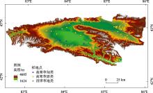
Fig. 1
Location and sample points of the study area"

Tab. 1
Vegetation index and calculation formula"
| 植被指数 | 计算公式 | 参考文献 |
|---|---|---|
| 归一化植被指数 | [ | |
| 差值植被指数 | [ | |
| 比值植被指数 | [ | |
| 增强型植被指数 | [ | |
| 土壤植被指数 | [ | |
| 三波段梯度差植被指数 | [ |
Tab. 2
Main plant species"
| 草地类 | 植物种类 |
|---|---|
| 高寒草甸类 | 白尖薹草(Carex oxyleuca) |
| 鬼箭锦鸡儿(Caragana jubata) | |
| 线叶嵩草(Kobresia capillifolia) | |
| 细果薹草(Carex stenocarpa) | |
| 珠芽蓼(Polygonum viviparum) | |
| 高寒草原类 | 新疆薹草(Carex turkestanica) |
| 溚草(Koeleria macrantha) | |
| 寒生羊茅(Festuca kryloviana) | |
| 宽穗赖草(Leymus ovatus) | |
| 冰草(Agropyron cristatum) | |
| 天山鸢尾(Iris loczyi Kanitz) | |
| 紫花针茅(Stipa purpurea) | |
| 椒蒿(Artemisia dracunculus) | |
| 野黑麦(Secale sylvestre) | |
| 冷蒿(Artemisia frigida) | |
| 座花针茅(Stipa subsessiliflora) | |
| 沼泽草地类 | 柄囊薹草(Carex stenophylla) |
| 布顿大麦草(Hordeum bogdanii) | |
| 扁灯芯草(Juncus compressus) |
Tab. 3
Grassland census data set in 1980s"
| 草地类 | 草地型 | 平均盖度/% | 总产草量/(kg·hm-2) | 平均高度/cm | |
|---|---|---|---|---|---|
| 高寒草甸类 | 白尖薹草、杂类草 | 85 | 3108.00 | 14.0 | 0.52 |
| 鬼箭锦鸡儿、线叶嵩草、杂类草 | 90 | 3199.50 | 25.0 | 0.78 | |
| 线叶嵩草 | 90 | 3237.00 | 20.0 | 0.68 | |
| 线叶嵩草、白尖薹草、杂类草 | 90 | 3031.50 | 20.0 | 0.68 | |
| 线叶嵩草、细果薹草、珠芽蓼 | 90 | 6631.50 | 17.5 | 0.75 | |
| 线叶嵩草、杂类草 | 90 | 7485.00 | 25.0 | 0.93 | |
| 珠芽蓼、细果薹草、杂类草 | 90 | 3247.50 | 12.5 | 0.53 | |
| 高寒草原类 | 新疆薹草、溚草 | 60 | 1546.50 | 16.5 | 0.34 |
| 新疆薹草、寒生羊茅 | 65 | 2173.50 | 15.0 | 0.37 | |
| 新疆薹草、宽穗赖草 | 40 | 5620.50 | 12.5 | 0.26 | |
| 新疆薹草、杂类草 | 60 | 4480.50 | 20.0 | 0.51 | |
| 寒生羊茅、冰草 | 50 | 1705.50 | 10.0 | 0.15 | |
| 寒生羊茅、新疆薹草、天山鸢尾 | 85 | 1770.00 | 15.0 | 0.50 | |
| 寒生羊茅、紫花针茅 | 50 | 1827.00 | 12.5 | 0.20 | |
| 宽穗赖草 | 35 | 1380.60 | 20.0 | 0.23 | |
| 宽穗赖草、椒蒿 | 35 | 1380.60 | 20.0 | 0.23 | |
| 天山鸢尾、新疆薹草、紫花针茅 | 85 | 1914.00 | 17.5 | 0.55 | |
| 天山鸢尾、寒生羊茅 | 85 | 1914.00 | 17.5 | 0.55 | |
| 野黑麦、杂类草 | 85 | 5319.00 | 22.5 | 0.77 | |
| 紫花针茅、冰草、杂类草 | 50 | 498.00 | 12.5 | 0.16 | |
| 紫花针茅、新疆薹草 | 50 | 951.00 | 17.5 | 0.27 | |
| 紫花针茅、新疆薹草、寒生羊茅 | 50 | 1827.00 | 12.5 | 0.20 | |
| 紫花针茅、寒生羊茅、冰草 | 50 | 1827.00 | 12.5 | 0.20 | |
| 紫花针茅、宽穗赖草 | 50 | 951.00 | 17.5 | 0.27 | |
| 紫花针茅、冷蒿 | 45 | 913.50 | 17.5 | 0.24 | |
| 紫花针茅、杂类草 | 50 | 951.00 | 17.5 | 0.27 | |
| 座花针茅、宽穗赖草 | 50 | 1380.60 | 20.0 | 0.34 | |
| 沼泽草地类 | 柄囊薹草 | 100 | 4128.00 | 17.5 | 0.73 |
| 布顿大麦草、扁灯芯草 | 100 | 4323.00 | 12.5 | 0.64 |
Tab. 4
Data set of construction points in 2021"
| 样地号 | 平均盖度/% | 总产草量/(kg·hm-2) | 平均高度/cm | |
|---|---|---|---|---|
| 001 | 75 | 3560.00 | 15.0 | 0.56 |
| 002 | 95 | 4336.00 | 15.0 | 0.70 |
| 003 | 100 | 6387.00 | 20.0 | 0.85 |
| 004 | 94 | 2013.00 | 6.0 | 0.52 |
| 005 | 100 | 10233.00 | 18.0 | 0.84 |
| 006 | 80 | 2263.33 | 7.0 | 0.46 |
| 007 | 84 | 2506.00 | 31.0 | 0.72 |
| 008 | 82 | 2586.00 | 12.0 | 0.53 |
| 009 | 60 | 1933.00 | 12.0 | 0.38 |
| 010 | 100 | 1870.00 | 12.0 | 0.61 |
| 011 | 70 | 1703.00 | 12.0 | 0.43 |
| 012 | 70 | 2503.00 | 22.0 | 0.56 |
| 013 | 50 | 2556.00 | 23.0 | 0.45 |
| 014 | 88 | 3566.00 | 27.0 | 0.74 |
| 015 | 80 | 1817.00 | 16.0 | 0.53 |
| 016 | 75 | 2460.00 | 15.0 | 0.52 |
| 017 | 65 | 1403.33 | 5.7 | 0.33 |
| 018 | 55 | 1160.00 | 5.3 | 0.26 |
| 019 | 65 | 776.67 | 4.0 | 0.29 |
| 020 | 75 | 2070.00 | 8.7 | 0.44 |
| 021 | 55 | 1210.00 | 5.0 | 0.26 |
| 022 | 55 | 520.00 | 3.7 | 0.22 |
| 023 | 90 | 2393.33 | 7.7 | 0.53 |
| 024 | 40 | 703.33 | 4.0 | 0.15 |
| 025 | 85 | 1576.67 | 8.3 | 0.48 |
| 026 | 40 | 710.00 | 4.3 | 0.15 |
| 027 | 41 | 1980.00 | 6.4 | 0.22 |
| 028 | 40 | 979.50 | 7.6 | 0.19 |
| 029 | 34 | 960.00 | 9.6 | 0.18 |
| 030 | 44 | 864.00 | 4.7 | 0.18 |
| 031 | 92 | 6853.00 | 34.0 | 0.95 |
| 032 | 95 | 2660.00 | 19.0 | 0.67 |
| 033 | 95 | 3240.00 | 9.7 | 0.61 |
| 034 | 84 | 2482.50 | 13.0 | 0.55 |
| 035 | 83 | 3720.00 | 11.5 | 0.57 |
Tab. 5
Index weight coefficient"
| 植被覆盖度 | 草层平均高度 | 总产草量 | |
|---|---|---|---|
| 20世纪80年代模型系数 | 0.59 | 0.36 | 0.30 |
| 2021年模型系数 | 0.59 | 0.44 | 0.32 |
| 20世纪80年代指标权重 | 0.47 | 0.29 | 0.24 |
| 2021年指标权重 | 0.44 | 0.32 | 0.24 |
| 权重平均值 | 0.46 | 0.30 | 0.24 |

Fig. 2
Degradation area map of different altitude gradients"

Tab. 6
Vegetation degradation in 2000, 2009 and 2021"
| 退化程度 | 1986—2000年 面积/hm2 | 1986—2000年 比例/% | 1986—2009年 面积/hm2 | 1986—2009年比例/% | 1986—2021年 面积/hm2 | 1986—2021年 比例/% |
|---|---|---|---|---|---|---|
| 重度退化 | 247967.37 | 16.47 | 163884.51 | 10.89 | 221458.95 | 14.71 |
| 中度退化 | 431370.63 | 28.66 | 193017.06 | 12.82 | 188894.07 | 12.55 |
| 轻度退化 | 243514.08 | 16.18 | 177344.28 | 11.78 | 184102.11 | 12.23 |
| 未退化 | 582457.77 | 38.69 | 971064.00 | 64.51 | 910854.72 | 60.51 |
| [1] | 张新时, 唐海萍, 董孝斌, 等. 中国草原的困境及其转型[J]. 科学通报, 2016, 61(2): 165-177. |
| [Zhang Xinshi, Tang Haiping, Dong Xiaobin, et al. The dilemma of steppe and it’s transformation in China[J]. Chinese Science Bulletin, 2016, 61(2): 165-177.] | |
| [2] | 沈海花, 朱言坤, 赵霞, 等. 中国草地资源的现状分析[J]. 科学通报, 2016, 61(2): 139-154. |
| [Shen Haihua, Zhu Yankun, Zhao Xia, et al. Analysis of current grassland resources in China[J]. Chinese Science Bulletin, 2016, 61(2): 139-154.] | |
| [3] | 杨红飞, 刚成诚, 穆少杰, 等. 近10年新疆草地生态系统净初级生产力及其时空格局变化研究[J]. 草业学报, 2014, 23(3): 39-50. |
| [Yang Hongfei, Gang Chengcheng, Mu Shaojie, et al. Analysis of the spatio-temporal variation in net primary productivity of grassland during the past 10 years in Xinjiang[J]. Acta Prataculturae Sinica, 2014, 23(3): 39-50.] | |
| [4] | 迪利夏提·哈斯木. 新疆草地资源现状与生态保护[J]. 新疆环境保护, 2013, 35(S1): 41-44. |
| [Dilixiati Hasimu. Current situation and ecological protection of grassland resources in Xinjiang[J]. Environmental Protection of Xinjiang, 2013, 35(S1): 41-44.] | |
| [5] | 李文利, 何文革. 新疆巴音布鲁克草原退化及其驱动力分析[J]. 青海草业, 2008, 17(2): 44-47. |
| [Li Wenli, He Wenge. The analysis on driven forces of degradation of Bayinbulake grassland in Xinjiang[J]. Qinghai Prataculture, 2008, 17(2): 44-47.] | |
| [6] |
张海燕, 樊江文, 邵全琴. 2000—2010年中国退牧还草工程区土地利用/覆被变化[J]. 地理科学进展, 2015, 34(7): 840-853.
doi: 10.18306/dlkxjz.2015.07.006 |
|
[Zhang Haiyan, Fan Jiangwen, Shao Quanqin. Land use/land cover change in the grassland restoration program areas in China, 2000-2010[J]. Progress in Geography, 2015, 34(7): 840-853.]
doi: 10.18306/dlkxjz.2015.07.006 |
|
| [7] | 仇焕广, 张崇尚, 刘乐, 等. 我国草原管理制度演变及社区治理机制创新[J]. 经济社会体制比较, 2020(3): 48-56. |
| [Qiu Huanguang, Zhang Chongshang, Liu Le, et al. Evolution of grassland management institutions and innovation of the local governance mechanism in China[J]. Comparative Economic & Social Systems, 2020(3): 48-56.] | |
| [8] |
Zhou Wei, Yang Han, Huang Lu, et al. Grassland degradation remote sensing monitoring and driving factors quantitative assessment in China from 1982 to 2010[J]. Ecological Indicators, 2017, 83: 303-313.
doi: 10.1016/j.ecolind.2017.08.019 |
| [9] |
吴晓全, 王让会, 李成, 等. 天山植被NPP时空特征及其对气候要素的响应[J]. 生态环境学报, 2016, 25(11): 1848-1855.
doi: 10.16258/j.cnki.1674-5906.2016.11.017 |
|
[Wu Xiaoquan, Wang ranghui, Li Cheng, et al. Spatial-temporal characteristics of NPP and its response to climatic factors in Tianshan Mountains region[J]. Ecology and Environmental Sciences, 2016, 25(11): 1848-1855.]
doi: 10.16258/j.cnki.1674-5906.2016.11.017 |
|
| [10] | 杜自强, 王建, 李建龙, 等. 黑河中上游典型地区草地植被退化遥感动态监测[J]. 农业工程学报, 2010, 26(4): 180-185. |
| [Du Ziqiang, Wang Jian, Li Jianlong, et al. Remote sensing-based monitor dynamically grassland degradation in typical regions, middle and upper reaches of Heihe River Basin, western China[J]. Transactions of the Chinese Society of Agricultural Engineering, 2010, 26(4): 180-185.] | |
| [11] | 赵玉婷, 李文龙, 陈迪, 等. 高寒牧区草地生态系统健康动态评价——以甘南地区为例[J]. 草业科学, 2017, 34(1): 16-29. |
| [Zhao Yuting, Li Wenlong, Chen Di, et al. Dynamic assessment of alpine pasture grassland ecosystem health: A case study from the Gannan region[J]. Pratacultural Science, 2017, 34(1): 16-29.] | |
| [12] | 陆均, 胡玉昆, 岳平, 等. 基于CVOR指数的巴音布鲁克高寒草原健康评价[J]. 干旱区研究, 2017, 34(4): 862-869. |
| [Lu Jun, Hu Yukun, Yue Ping, et al. Assessment on the health of alpine steppe in Bayinbuluk based on CVOR index[J]. Arid Zone Research, 2017, 34(4): 862-869.] | |
| [13] | 吴志丰, 李芬, 张林波, 等. 三江源区草地参照覆盖度提取及草地退化研究[J]. 自然灾害学报, 2014, 23(2): 94-102. |
| [Wu Zhifeng, Li Fen, Zhang Linbo, et al. Research on grassland degradation of Three-River headwaters region based on reference vegetation coverage[J]. Journal of Natural Disasters, 2014, 23(2): 94-102.] | |
| [14] | 李霞, 潘冬荣, 孙斌, 等. 甘肃省草地退化概况分析——基于甘肃省第一、二次草原普查数据[J]. 草业科学, 2022, 39(3): 485-494. |
| [Li Xia, Pan Dongrong, Sun Bin, et al. Analysis of grassland degradation in Gansu Province based on two grassland surveys[J]. Pratacultural Science, 2022, 39(3): 485-494.] | |
| [15] |
Yang Yanlin, Wang Jinliang, Chen Yun, et al. Remote-sensing monitoring of grassland degradation based on the GDI in Shangri-La, China[J]. Remote Sensing, 2019, 11(24): 3030.
doi: 10.3390/rs11243030 |
| [16] | 公延明, 胡玉昆, 阿德力·麦地, 等. 巴音布鲁克高寒草地退化演替阶段植物群落特性研究[J]. 干旱区资源与环境, 2010, 24(6): 149-152. |
| [Gong Yanming, Hu Yukun, Adeli Maidi, et al Alpine grassland community characteristics at the different stages of degenerating succession in Bayanbulak[J]. Journal of Arid Land Resources and Environment, 2010, 24(6): 149-152.] | |
| [17] |
Choi Jaewon, Oh Hyun-Joo, Won Joong-Sun, et al. Validation of an artificial neural network model for landslide susceptibility mapping[J]. Environmental Earth Sciences, 2010, 60(3): 473-483.
doi: 10.1007/s12665-009-0188-0 |
| [18] | 张雨斯, 包玉海, 贺忠华. 1990—2021年内蒙古遥感生态环境质量变化及趋势分析——以呼伦贝尔市陈巴尔虎旗为例[J]. 干旱区研究, 2023, 40(2): 326-336. |
| [Zhang Yusi, Bao Yuhai, He Zhonghua. Detecting the change and trend of remote sensing ecological quality in Inner Mongolia from 1990-2021: A case study of Chenbarhu Banner of Hulunbuir City[J]. Arid Zone Research, 2023, 40(2): 326-336.] | |
| [19] | 冯双双. 基于Landsat影像的草地退化动态监测[D]. 石家庄: 河北师范大学, 2016. |
| [Feng Shuangshuang. Dynamic Monitoring of Grassland Degradation Based on Landsat Image[D]. Shijiazhuang: Hebei Normal University, 2016.] | |
| [20] |
Lyu Xin, Li Xiaobing, Gong Jirui, et al. Comprehensive grassland degradation monitoring by remote sensing in Xilinhot, Inner Mongolia, China[J]. Sustainability, 2020, 12(9): 3682.
doi: 10.3390/su12093682 |
| [21] | 徐剑波, 宋立生, 赵之重, 等. 近15 a来黄河源地区玛多县草地植被退化的遥感动态监测[J]. 干旱区地理, 2012, 35(4): 615-622. |
| [Xu Jianbo, Song Lisheng, Zhao Zhizhong, et al. Monitoring grassland degradation dynamically at Maduo County in source region of Yellow River in past 15 years based on remote sensing[J]. Arid Land Geography, 2012, 35(4): 615-622.] | |
| [22] |
Li Lanhui, Zhang Yili, Liu Linshan, et al. Spatiotemporal patterns of vegetation greenness change and associated climatic and anthropogenic drivers on the Tibetan Plateau during 2000-2015[J]. Remote Sensing, 2018, 10(10): 1525.
doi: 10.3390/rs10101525 |
| [23] |
Tucker J Compton. Red and photographic infrared linear combinations for monitoring vegetation[J]. Remote Sensing of Environment, 1979, 8(2): 127-150.
doi: 10.1016/0034-4257(79)90013-0 |
| [24] | Richardson A J, Wiegand C L. Distinguishing vegetation from soil background information[J]. Photogrammetric Engineering and Remote Sensing, 1977, 43(12): 1541-1552. |
| [25] |
Jordan C F. Derivation of leaf area index from light quality of the forest floor[J]. Ecology, 1969, 50(4): 663-666.
doi: 10.2307/1936256 |
| [26] |
Liu Jiangui, Shang Jiali, Qian Budong, et al. Crop yield estimation using time-series MODIS data and the effects of cropland masks in Ontario, Canada[J]. Remote Sensing, 2019, 11(20): 2419.
doi: 10.3390/rs11202419 |
| [27] |
Huete A R. A soil-adjusted vegetation index (SAVI)[J]. Remote Sensing of Environment, 1988, 25(3): 295-309.
doi: 10.1016/0034-4257(88)90106-X |
| [28] | 唐世浩, 朱启疆, 王锦地, 等. 三波段梯度差植被指数的理论基础及其应用[J]. 中国科学(D辑:地球科学), 2003, 33(11): 1094-1102. |
| [Tang Shihao, Zhu Qijiang, Wang Jindi, et al. Theoretical basis and application of three band gradient difference vegetation index[J]. Chinese Science (Series D: Earth Science), 2003, 33(11): 1094-1102.] | |
| [29] | 中华人民共和国国家质量监督检验检疫总局. GB 19377-2003. 天然草地退化、沙化、盐渍化的分级指标[S]. 2003. |
| [General Administration of Quality Supervision. GB 19377-2003. Parameters for Degradation, Sandification and Salification of Rangeland[S]. 2003.] | |
| [30] | 曹旭娟, 干珠扎布, 梁艳, 等. 基于NDVI的藏北地区草地退化时空分布特征分析[J]. 草业学报, 2016, 25(3): 1-8. |
| [Cao Xujuan, Ganzhu Zhabu, Liang Yan, et al. Temporal and spatial distribution of grassland degradation in northern Tibet based on NDVI[J]. Acta Prataculturae Sinica, 2016, 25(3): 1-8.] | |
| [31] |
李莉, 李峰. 基于RS和GIS的四川草地退化分析[J]. 中国农学通报, 2017, 33(17): 87-91.
doi: 10.11924/j.issn.1000-6850.casb16090006 |
|
[Li Li, Li Feng. Grassland degradation analysis in Sichuan based on RS and GIS[J]. Chinese Agricultural Science Bulletin, 2017, 33(17): 87-91.]
doi: 10.11924/j.issn.1000-6850.casb16090006 |
|
| [32] | 朱宁, 王浩, 宁晓刚, 等. 草地退化遥感监测研究进展[J]. 测绘科学, 2021, 46(5): 66-76. |
| [Zhu Ning, Wang Hao, Ning Xiaogang, et al. Advances in remote sensing monitoring of grassland degradation[J]. Science of Surveying and Mapping, 2021, 46(5): 66-76.] | |
| [33] | 焦阿永, 陈伏龙, 闫俊杰, 等. 北疆地区草地TI-NDVI与NDVImax时空异质性评价[J]. 干旱区研究, 2022, 39(4): 1155-1165. |
| [Jiao Ayong, Chen Fulong, Yan Junjie, et al. Spatio-temporal heterogeneity evaluation of grassland TI-NDVI and NDVImax in northern Xinjiang[J]. Arid Zone Research, 2022, 39(4): 1155-1165.] | |
| [34] |
Gang C, Zhou W, Wang Z, et al. Comparative assessment of grassland NPP dynamics in response to climate change in China, North America, Europe and Australia from 1981 to 2010[J]. Journal of Agronomy and Crop Science, 2015, 201(1): 57-68.
doi: 10.1111/jac.12088 |
| [35] | 张文博. 基于MODIS数据的草地退化遥感监测方法研究[D]. 北京: 中国农业科学院, 2020. |
| [Zhang Wenbo. Research on Remote Sensing Monitoring Method of Grassland Degradation Using MODIS Data[D]. Beijing: Chinese Academy of Agricultural Sciences, 2020.] | |
| [36] |
Fu Aihong, Chen Yaying, Li Weihong, et al. Spatial and temporal patterns of climate variations in the Kaidu River Basin of Xinjiang, Northwest China[J]. Quaternary International, 2013, 311: 117-122.
doi: 10.1016/j.quaint.2013.08.041 |
| [37] | 刘濛濛, 隆永兰. 巴音布鲁克近58 a气候变化特征分析[J]. 干旱区地理, 2019, 42(4): 715-723. |
| [Liu Mengmeng, Long Yonglan. Climatic variation characteristics in Bayinbuluk during the past 58 years[J]. Arid Land Geography, 2019, 365 42(4): 715-723.] | |
| [38] |
赵鹏, 陈桃, 王茜, 等. 气候变化和人类活动对新疆草地生态系统NPP影响的定量分析[J]. 中国科学院大学学报, 2020, 37(1): 51-62.
doi: 10.7523/j.issn.2095-6134.2020.01.007 |
|
[Zhao Peng, Chen Tao, Wang Qian, et al. Quantitative analysis of the impact of climate change and human activities on grassland ecosystem NPP in Xinjiang[J]. Journal of university of Chinese Academy of Sciences, 2020, 37(1): 51-62.]
doi: 10.7523/j.issn.2095-6134.2020.01.007 |
|
| [39] | 姚俊强, 李漠岩, 迪丽努尔·托列吾别克, 等. 不同时间尺度下新疆气候“暖湿化”特征[J]. 干旱区研究, 2022, 39(2): 333-346. |
| [Yao Junqiang, Li Moyan, Dilinuer Tuoliewubieke, et al. The assessment on“warming-wetting”trend in Xinjiang at multi-scale during 1961-2019[J]. Arid Zone Research, 2022, 39(2): 333-346.] | |
| [40] | 曹永香, 毛东雷, 薛杰, 等. 绿洲-沙漠过渡带植被覆盖动态变化及其驱动因素——以新疆策勒为例[J]. 干旱区研究, 2022, 39(2): 510-521. |
| [Cao Yongxiang, Mao Donglei, Xue Jie, et al. Dynamic changes and driving factors of vegetation cover in the oasis-desert ecotone: A case study of Cele, Xinjiang[J]. Arid Zone Research, 2022, 39(2): 510-521.] | |
| [41] | 潘庆民, 薛建国, 陶金, 等. 中国北方草原退化现状与恢复技术[J]. 科学通报, 2018, 63(17): 1642-1650. |
| [Pan Qingmin, Xue Jianguo, Tao Jin, et al. Current status of grassland degradation and measures for grassland restoration in northern China[J]. Chinese Science Bulletin, 2018, 63(17): 1642-1650.] |
| [1] | GAO Xiaoyu,TANG Pengcheng,ZHANG Sha,QU Zhongyi,YANG Wei. Drought characteristics and regression models of drought characteristics and response factors of various climatic areas in Inner Mongolia during main crop growing season [J]. Arid Zone Research, 2022, 39(5): 1410-1427. |
| [2] | YANG Fucheng,LIU Changyi,HU Xiasong,LI Xilai,FU Jiangtao,LU Haijing,SHEN Ziyan,XU Tong,YAN Cong,HE Weipeng. Study on physical and chemical properties and shear strength characteristics of root-soil composite system with different degradation degrees of alpine grassland in the source region of the Yellow River [J]. Arid Zone Research, 2022, 39(2): 560-571. |
|
||