Arid Zone Research ›› 2021, Vol. 38 ›› Issue (4): 1031-1039.doi: 10.13866/j.azr.2021.04.14
• Weather and Climate • Previous Articles Next Articles
LI Shuai1( ),CHEN Yonghang1(),HOU Xiaogang2,WANG Junhai3,XU Zhide4
Received:2021-01-22
Revised:2021-02-25
Online:2021-07-15
Published:2021-08-03
Contact:
Yonghang CHEN
E-mail:rainlishuai@163.com;yonghangchen@126.com
LI Shuai,CHEN Yonghang,HOU Xiaogang,WANG Junhai,XU Zhide. Evaluation of FY-2F satellite cloud products in Xinjiang[J].Arid Zone Research, 2021, 38(4): 1031-1039.
Add to citation manager EndNote|Reference Manager|ProCite|BibTeX|RefWorks
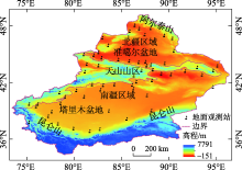
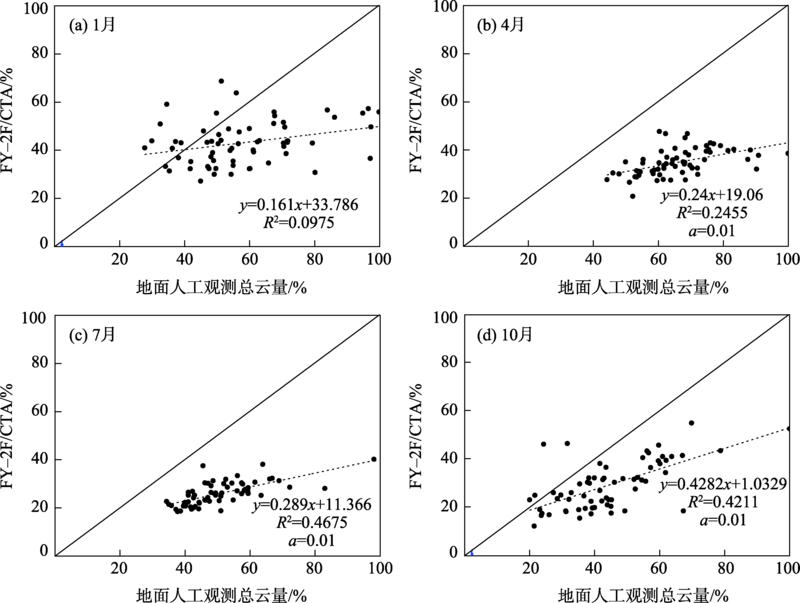
Fig. 1
Overview of the geographic location and topography of Xinjiang"

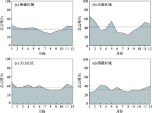
Fig. 2
Monthly variation of total cloud cover in different regions of Xinjiang"
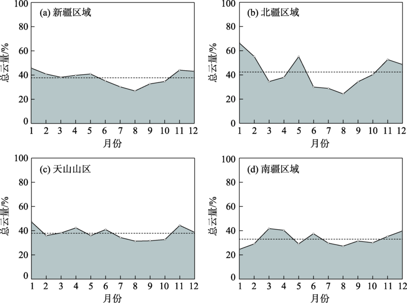
Fig. 3
Total cloud cover scatter plot of FY-2F/CTA and manual observed in Xinjiang region"
Tab. 1
Correlation between FY-2F/CTA and manual observed total cloud cover in different seasons and region of Xinjiang"
| 拟合方程(北疆地区) | R | 拟合方程(天山山区) | R | 拟合方程(南疆地区) | R | |
|---|---|---|---|---|---|---|
| 春季 | y=2.744+1.011x | 0.830** | y=1.005+1.320x | 0.793* | y=2.978+0.947x | 0.788* |
| 夏季 | y=1.305+1.313x | 0.899** | y=0.969+1.392x | 0.830** | y=2.151+1.207x | 0.861** |
| 秋季 | y=1.582+1.137x | 0.843** | y=1.042+1.215x | 0.761* | y=1.224+1.206x | 0.832** |
| 冬季 | y=2.557+0.690x | 0.466 | y=0.445+0.990x | 0.529 | y=2.406+0.883x | 0.737* |
Fig. 4
Consistency box plot of FY-2F/CTA products and manual observed cloud cover in different season of Xinjiang"
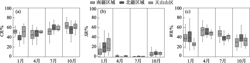
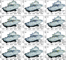
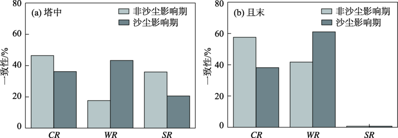
Fig. 5
Consistency spatial distribution map of FY-2F/CTA under different cloud cover levels in Xinjiang"

Fig. 6
Consistency of FY-2F/CTA products and manual observed total cloud cover in dust and no dust effect period of Xinjiang"
| [1] | 王帅辉, 韩志刚, 姚志刚. 基于CloudSat和ISCCP资料的中国及周边地区云量分布的对比分析[J]. 大气科学, 2010, 34(4):767-779. |
| [ Wang Shuaihui, Han Zhigang, Yao Zhigang. Comparis on of cloud amounts from ISCCP and CloudSat over China and its neighborhood[J]. Chinese Journal of Atmospheric Sciences, 2010, 34(4):767-779. ] | |
| [2] |
Yu H, Kaufman Y J, Chin M, et al. A review of measurement based assessments of the aerosol direct radiative effect and forcing[J]. Atmospheric Chemistry and Physics, 2006, 6(11):613-666.
doi: 10.5194/acp-6-613-2006 |
| [3] |
Stephens G S, Kummerow G D. The remote sensing of clouds and precipitation from space: A review[J]. Journal of the Atmospheric Sciences, 2007, 64(11):3742-3765.
doi: 10.1175/2006JAS2375.1 |
| [4] | 吴伟, 王式功. 中国北方云量变化趋势及其与区域气候的关系[J]. 高原气象, 2011, 30(3):651-658. |
| [ Wu Wei, Wang Shigong. Tendency change of cloud cover over northern China and its relation with regional climate[J]. Plateau Meteorology, 2011, 30(3):651-658. ] | |
| [5] | 杨冰韵, 吴晓京, 郭徵. 基于CloudSat资料的中国地区深对流云物理特征研究[J]. 高原气象, 2017, 36(6):1655-1664. |
| [ Yang Bingyun, Wu Xiaojing, Guo Zheng. The characteristics of cloud properties in deep convective clouds across China with the CloudSat dataset[J]. Plateau Meteorology, 2017, 36(6):1655-1664. ] | |
| [6] |
Webb M J, Senior C A, Sexton D M H, et al. On the contribution of local feedback mechanisms to the range of climate sensitivity in two GCM ensembles[J]. Climate Dynamics, 2006, 27(7):17-38.
doi: 10.1007/s00382-006-0111-2 |
| [7] |
Ronald M Errico, George Ohring, Weng Fuzhong, et al. Assimilation of satellite cloud and precipitation observations in numerical weather prediction models: Introduction to the J A S special collection[J]. Journal of the Atmospheric Sciences, 2007, 64(11):3737-3741.
doi: 10.1175/2007JAS2622.1 |
| [8] | 丁守国, 石广玉, 赵春生. 利用 ISCCP D2 资料分析近20年全球不同云类云量的变化及其对气候可能的影响[J]. 科学通报, 2004, 49(11):1105-1111. |
| [ Ding Shouguo, Shi Guangyu, Zhao Chunsheng. Analyzing global trends of different cloud types and the their potential impacts on climate by using the ISCCP D2 dataset[J]. Chinese Science Bulletin, 2004, 49(11):1105-1111. ] | |
| [9] | 杜川利, 余兴, 李星敏, 等. 过去60 年中国秦岭地区云量变化及原因分析[J]. 高原气象, 2012, 31(5):446-455. |
| [ Du Chuanli, Yu Xing, Li Xingmin, et al. Analysis on cloudiness change in Qinling Mountain Region and its possible reason in past 60 years[J]. Plateau Meteorology, 2012, 31(5):446-455. ] | |
| [10] | 杜亮亮, 李江萍, 陈晓燕, 等. 2001—2011年青藏高原东北边坡地带云水资源分析[J]. 干旱区研究, 2012, 29(5):862-869. |
| [ Du Liangliang, Li Jiangping, Chen Xiaoyan, et al. Analysis on cloud and vapor flux in the northeast of the Qinghai-Tibet Plateau during the period from 2001 to 2011[J]. Arid Zone Research, 2012, 29(5):862-869. ] | |
| [11] | 薛小宁, 邓小波, 刘贵华. 基于卫星资料的青藏高原卷云特性研究[J]. 高原气象, 2018, 37(2):505-513. |
| [ Xue Xiaoning, Deng Xiaobo, Liu Guihua. Study on characteristics of Qinghai-Tibetan Plateau cirrus based on satellite data[J]. Plateau Meteorology, 2018, 37(2):505-513. ] | |
| [12] | 王洪强, 陈勇航, 彭宽军, 等. 基于Aqua卫星总云量资料分析山区云水资源[J]. 自然资源学报, 2011, 26(1):89-96. |
| [ Wang Hongqiang, Chen Yonghang, Peng Kuanjun, et al. Study on cloud water resources of mountain ranges in Xinjiang based on Aqua satellite data[J]. Journal of Natural Resources, 2011, 26(1):89-96. ] | |
| [13] | 张小娟, 王军, 黄观, 等. 新疆3大山区云中液态水时空分布特征[J]. 干旱区研究, 2018, 35(4):846-854. |
| [ Zhang Xiaojuan, Wang Jun, Huang Guan, et al. Spatiotemporal distribution of cloud liquid water volume over three main mountains in Xinjiang[J]. Arid Zone Research, 2018, 35(4):846-854. ] | |
| [14] |
Kotarba A Z. A comparison of MODIS-derived cloud amount with visual surface observations[J]. Atmospheric Research, 2009, 92(4):522-530.
doi: 10.1016/j.atmosres.2009.02.001 |
| [15] |
Werkmeister A, Lockhoff M, Schrempf M, et al. Comparing satellite to ground-based automated and manual cloud coverage observations: A case study[J]. Atmospheric Measurement Techniques, 2015, 8(5):2001-2015.
doi: 10.5194/amt-8-2001-2015 |
| [16] | 刘瑞霞, 陈洪滨, 郑照军, 等. 总云量产品在中国区域的分析检验[J]. 应用气象学报, 2009, 20(5):571-578. |
| [ Liu Ruixia, Chen Hongbin, Zheng Zhaojun, et al. Analysis and validation of total cloud amount data in China[J]. Journal of Applied Meteorological Science, 2009, 20(5):571-578. ] | |
| [17] | 王旻燕, 王伯民. ISCCP产品和我国地面观测总云量差异[J]. 应用气象学报, 2009, 20(4):411-418. |
| [ Wang Minyan, Wang Bomin. Total cloud amount difference between ISCCP product and ground observation over China[J]. Journal of Applied Meteorological Science, 2009, 20(4):411-418. ] | |
| [18] | 刘健, 杨晓峰, 崔鹏. NOAA卫星2007年总云量数据精度评估[J]. 高原气象, 2016, 35(4):1027-1038. |
| [ Liu Jian, Yang Xiaofeng, Cui Peng. Validation of total cloud amount in 2007 derived by NOAA/AVHRR[J]. Plateau Meteorology, 2016, 35(4):1027-1038. ] | |
| [19] | 李娅, 郭建侠, 曹云昌, 等. FY-2G云量产品与地面观测云量对比分析[J]. 高原气象, 2018, 37(2):514-523. |
| [ Li Ya, Guo Jianxia, Cao Yunchang, et al. Compare and analyze FY-2G cloud products to ground-based manual observed cloud amount[J]. Plateau Meteorology, 2018, 37(2):514-523. ] | |
| [20] | 刘健, 崔鹏, 肖萌. FY-2G卫星冬夏云量产品偏差分析[J]. 应用气象学报, 2017, 28(2):77-188. |
| [ Liu Jian, Cui Peng, Xiao Meng. The bias analysis of FY-2G cloud fraction in summer and winter[J]. Journal of Applied Meteorological Science, 2017, 28(2):77-188. ] | |
| [21] | 韩永清, 丛春华. FY-2E总云量产品在华北和黄淮区域的分析检验[J]. 气象与环境学报, 2015, 31(5):153-158. |
| [ Han Yongqin, Cong Chunhua. Analysis and validation of FY-2E total cloud amount productions in north China and Huanghuai area[J]. Journal of Meteorology and Environment, 2015, 31(5):153-158. ] | |
| [22] | 席琳, 师春香, 赵笔峰, 等. 1995—2010 年静止卫星云量数据检验和评价[J]. 气象科技, 2013, 41(1):8-14. |
| [ Xi Lin, Shi Chunxiang, Zhao Bifeng, et al. Validation and evaluation of cloud amount by geostationary satellite from 1995 to 2010[J]. Meteorological Science and Technology, 2013, 41(1):8-14. ] | |
| [23] | 彭宽军, 陈勇航, 王文彩, 等. 新疆山区低层云水资源时空分布特征[J]. 水科学进展, 2010, 21(5):653-659. |
| [ Peng Kuanjun, Chen Yonghang, Wang Wencai, et al. Characteristics of spatial and temporal distribution of lower layer cloud water resources in Xinjiang mountain regions[J]. Advances in Water Science, 2010, 21(5):653-659. ] | |
| [24] | 刘岩, 马骁骏, 李浩, 等. 基于CloudSat和Aqua卫星资料的北疆一次暴雪过程中云的宏微观物理属性[J]. 沙漠与绿洲气象, 2015, 9(2):9-15. |
| [ Liu Yan, Ma Xiaojun, Li Hao, et al. Cloud macro and micro physical properties during a snowstorm based on CloudSat and Aqua satellite data[J]. Desert and Oasis Meteorology, 2015, 9(2):9-15. ] | |
| [25] | 冯建东, 武志婷, 彭宽军, 等. 基于CloudSat 卫星资料的新疆三大山区不同类型云高特征研究[J]. 冰川冻土, 2014, 36(2):310-317. |
| [ Feng Jiandong, Wu Zhiting, Peng Kuanjun, et al. Variations in the heights of different clouds over three major mountains in Xinjiang based on CloudSat observation[J]. Journal of Glaciology and Geocryology, 2014, 36(2):310-317. ] | |
| [26] | 张萍, 彭宽军, 陈勇航, 等. 新疆三大山区云的垂直分布特征初探[J]. 资源科学, 2011, 33(11):2090-2098. |
| [ Zhang Ping, Peng Kuanjun, Chen Yonghang, et al. A preliminary study of vertical distribution of clouds over three major mountains in Xingjiang[J]. Resource Since, 2011, 33(11):2090-2098. ] | |
| [27] | 李帅, 侯小刚, 崔宇, 等. 基于FY-2F资料的新疆区域云系特征研究[J]. 高原气象, 2019, 38(3):617-624. |
| [ Li Shuai, Hou Xiaogang, Cui Yu, et al. Research on cloud characteristics in Xinjiang region based on FY-2F satellite data[J]. Plateau Meteorology, 2019, 38(3):617-624. ] | |
| [28] | 周成龙, 杨兴华, 钟昕洁, 等. 塔克拉玛干沙漠腹地沙尘天气特征[J]. 干旱区研究, 2017, 34(2):324-329. |
| [ Zhou Chenglong, Yang Xinghua, Zhong Xinjie, et al. Dust weather in hinterland of the Taklamakan desert[J]. Arid Zone Research, 2017, 34(2):324-329.] |
| [1] | LI Xiaofeng, HUI Tingting, LI Yaoming, MAO Jiefei, WANG Guangyu, FAN Lianlian. Effects of different grazing management strategies on plant diversity in the mountain grassland of Xinjiang, China [J]. Arid Zone Research, 2024, 41(1): 124-134. |
| [2] | ZHANG Sheng, ZHANG Tao, DUAN Wenyu, XU Li, Gu Jinyang, ZHANG Wei, LI Simin. Evaluation of the environmental quality of surface water in Chengde using improved methods [J]. Arid Zone Research, 2024, 41(1): 50-59. |
| [3] | MA Zhengang,LI Lili,ZHANG Jungui. Comparative study on water area changes and influencing factors in the Guanting and Miyun reservoirs [J]. Arid Zone Research, 2023, 40(8): 1229-1239. |
| [4] | WANG Xiang, LYU Haishen, ZHU Yonghua, GUO Chenyu. Application and comparison of two channel flood routing methods in Xinjiang mountainous areas [J]. Arid Zone Research, 2023, 40(8): 1240-1247. |
| [5] | WANG Chao, MA Zhancang, PAN Chengnan, WU Xingyue, SONG Wendan, YAN Ping. New records of Amaranthus in Xinjiang [J]. Arid Zone Research, 2023, 40(8): 1280-1288. |
| [6] | Gulistan ANWAR, Turgun NURDIN, Dilhumar ABDUKERIM, Mamtimin SULAYMAN. New records of mosses of Leskeaceae to Xinjiang [J]. Arid Zone Research, 2023, 40(8): 1289-1293. |
| [7] | LI Hong, LI Zhongqin, CHEN Puchen, PENG Jiajia. Spatio-temporal variation of snow cover in Altai Mountains of Xinjiang in recent 20 years and its influencing factors [J]. Arid Zone Research, 2023, 40(7): 1040-1051. |
| [8] | XU Junli, HAN Haidong, WANG Jian. Recharge sources and potential source areas of atmospheric PM2.5 in Xinjiang [J]. Arid Zone Research, 2023, 40(6): 874-884. |
| [9] | XUE Yibo, HUANG Shuangyan, ZHANG Xiaoxiao, LEI Jiaqiang, LI Shengyu. Study on the strong winter airborne dustfall mixed rain and snow events in Xinjiang, China in 2018 [J]. Arid Zone Research, 2023, 40(5): 681-690. |
| [10] | ZHAO Keming, SUN Mingjing, LI Xia, SHI Junjie, AN Dawei, XU Tingting. Comparison of the distribution and applicability of two typical atmospheric diffusion indices in Xinjiang [J]. Arid Zone Research, 2023, 40(5): 691-702. |
| [11] | CUI Shuai, XU Qiang, YUAN Shuang, PU Chuanhao, CHEN Wanlin, JI Xu. Evaluation of Dongzhi Loess Plateau Gully development based on combined entropy weight Rank-Sum Ratio method [J]. Arid Zone Research, 2023, 40(3): 481-491. |
| [12] | ZHAO Yuzhi,YANG Jianjun. Spatio-temporal pattern of water resource carrying capacity, coupling and coordination of subsystems in southern Xinjiang [J]. Arid Zone Research, 2023, 40(2): 213-223. |
| [13] | DONG Hanlin, WANG Wenting, XIE Yun, Aydana YESINALI, JIANG Yuantian, XU Jiaqi. Climate dry-wet conditions, changes, and their driving factors in Xinjiang [J]. Arid Zone Research, 2023, 40(12): 1875-1884. |
| [14] | XIAO Xu, ZHENG Cheng, DING Chengqin, FAN Chenzhe, BAI Yuejiang, LIN Longchao, YAN Ting, GAO Yu, SHI Haijing. Comparative analysis of the temperatures and rainfall in loess hilly regions using the ANUSPLIN model [J]. Arid Zone Research, 2023, 40(10): 1575-1582. |
| [15] | LI Erchen, ZHANG Yu, YUAN Guanghui. Quantify the impacts of four land cover types on surface temperature in the Heihe River Basin [J]. Arid Zone Research, 2023, 40(1): 30-38. |
|
||