Arid Zone Research ›› 2021, Vol. 38 ›› Issue (4): 939-949.doi: 10.13866/j.azr.2021.04.05
• Water Resources and Utilization • Previous Articles Next Articles
CHANG Mengdi1,2( ),WANG Xinjun1,2(),LI Na1,2,YAN Linan1,2,MA Ke1,2,LI Juyan3
Received:2020-11-16
Revised:2021-01-25
Online:2021-07-15
Published:2021-08-03
Contact:
Xinjun WANG
E-mail:1761316194@qq.com;wxj8112@163.com
CHANG Mengdi,WANG Xinjun,LI Na,YAN Linan,MA Ke,LI Juyan. Study on temporal and spatial variation characteristics and influencing factors of hydraulic erosion in the middle of the northern slope of Tianshan Mountains based on CSLE model[J].Arid Zone Research, 2021, 38(4): 939-949.
Add to citation manager EndNote|Reference Manager|ProCite|BibTeX|RefWorks

Fig. 1
Diagram of the study area"
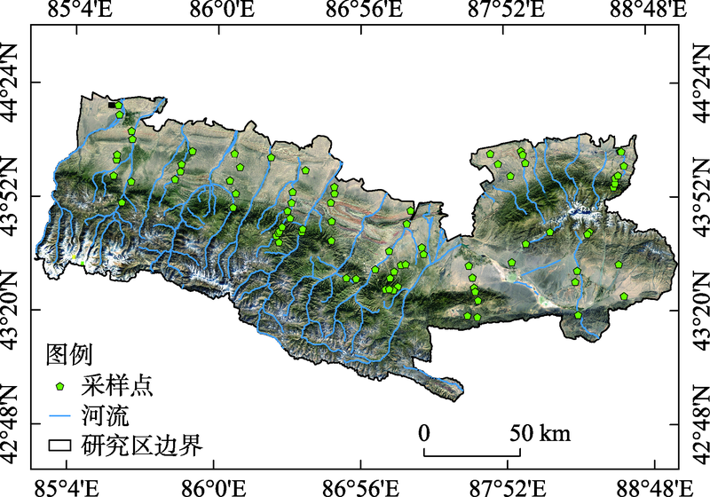

Fig. 2
Linear relationship between NDVI and vegetation coverage of grassland, shrub land and canopy density of arbor forest land"

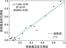
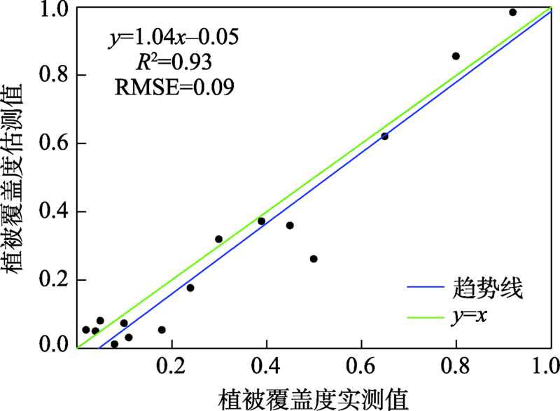
Fig. 3
Linear relationship between measured and estimated vegetation coverage"
Tab. 1
Proportion and change rate of different soil hydraulic erosion intensity area in the middle of the northern slope of Tianshan Mountains from 2000 to 2018"
| 侵蚀级别 | 面积百分比/% | 面积变化率/ (km2·a-1) | |||
|---|---|---|---|---|---|
| 最大值 | 最小值 | 平均值 | 标准偏差 | ||
| 微度 | 40.87 | 32.34 | 36.99 | 2.69 | -26.70 |
| 轻度 | 43.01 | 33.36 | 38.37 | 3.11 | -77.47 |
| 中度 | 13.84 | 7.37 | 10.40 | 1.39 | 22.27 |
| 强烈 | 7.66 | 3.08 | 5.32 | 1.17 | 22.10 |
| 极强烈 | 7.29 | 2.97 | 4.63 | 1.38 | 28.84 |
| 剧烈 | 7.52 | 1.57 | 4.30 | 1.95 | 30.96 |
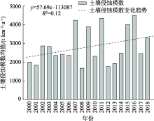
Fig. 4
Changes of annual average soil erosion modulus in the middle of the northern slope of Tianshan Mountains from 2000 to 2018"

Tab. 2
Area and proportion of different soil hydraulic erosion intensity in the middle of the northern slope of Tianshan Mountains from 2000 to 2018"
| 年份 | 土壤侵蚀 | |||||||||||||||||||
|---|---|---|---|---|---|---|---|---|---|---|---|---|---|---|---|---|---|---|---|---|
| 微度 | 轻度 | 中度 | 强烈 | 极强烈 | 剧烈 | 合计 | ||||||||||||||
| 面积/km2 | 比例/% | 面积/km2 | 比例/% | 面积/km2 | 比例/% | 面积/km2 | 比例/% | 面积/km2 | 比例/% | 面积/km2 | 比例/% | 面积/km2 | 比例/% | |||||||
| 2000 | 11362.58 | 40.54 | 12054.92 | 43.01 | 2066.71 | 7.37 | 864.03 | 3.08 | 831.61 | 2.97 | 846.98 | 3.02 | 16664.26 | 59.46 | ||||||
| 2005 | 9986.28 | 35.63 | 11590.47 | 41.35 | 2882.38 | 10.28 | 1393.46 | 4.97 | 1184.96 | 4.23 | 989.29 | 3.53 | 18040.55 | 64.37 | ||||||
| 2010 | 9747.85 | 34.78 | 11443.27 | 40.83 | 3278.11 | 11.70 | 1683.56 | 6.01 | 1085.06 | 3.87 | 789.00 | 2.82 | 18278.99 | 65.22 | ||||||
| 2015 | 9063.53 | 32.34 | 9350.84 | 33.36 | 3879.32 | 13.84 | 2145.91 | 7.66 | 1795.91 | 6.41 | 1791.33 | 6.39 | 18963.31 | 67.66 | ||||||
| 2018 | 10550.34 | 37.64 | 10130.22 | 36.14 | 2736.21 | 9.76 | 1485.57 | 5.30 | 1527.08 | 5.45 | 1597.43 | 5.70 | 17476.49 | 62.36 | ||||||
Tab. 3
Soil erosion modulus of different administrative regions in the middle of the northern slope of Tianshan Mountains from 2000 to 2018"
| 行政区 | 面积/km2 | 平均值/(t·km-2·a-1) | 标准偏差 |
|---|---|---|---|
| 乌鲁木齐市 | 10207.93 | 3595.54 | 1383.32 |
| 昌吉市 | 3258.90 | 3321.55 | 1182.19 |
| 阜康市 | 2096.09 | 3256.73 | 1170.54 |
| 呼图壁县 | 3143.32 | 2251.31 | 704.94 |
| 玛纳斯县 | 3107.89 | 2136.43 | 712.25 |
| 沙湾县 | 6126.55 | 1752.93 | 767.79 |
| 石河子市 | 68.86 | 1651.66 | 648.60 |
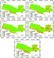
Fig. 5
Classification of soil hydraulic erosion intensity in the middle of the northern slope of Tianshan Mountains from 2000 to 2018"

Tab. 4
Soil erosion modulus of different rainfalls in the middle of the northern slope of Tianshan Mountains from 2000 to 2018"
| 降雨量/mm | 面积/km2 | 平均值/(t·km-2·a-1) | 标准偏差 |
|---|---|---|---|
| <200 | 1658.59 | 2416.40 | 882.16 |
| 200~250 | 13440.73 | 2193.76 | 740.47 |
| 250~300 | 5938.33 | 3845.19 | 1378.17 |
| 300~350 | 3537.69 | 2712.73 | 984.20 |
| 350~400 | 1481.54 | 2707.38 | 1037.19 |
| 400~450 | 1390.05 | 5159.30 | 2119.70 |
| >450 | 562.61 | 3247.77 | 1435.89 |
Tab. 5
Soil erosion modulus of different slopes in the middle of the northern slope of Tianshan Mountains from 2000 to 2018"
| 坡度/(°) | 面积/km2 | 平均值 /(t·km-2·a-1) | 标准偏差 | 合计 /(106 t·a-1) | 模数比例 /% |
|---|---|---|---|---|---|
| <5 | 6211.81 | 491.33 | 169.21 | 3.05 | 3.87 |
| 5~15 | 8143.32 | 1691.67 | 561.92 | 13.78 | 17.45 |
| 15~25 | 5262.29 | 3211.45 | 1078.22 | 16.90 | 21.41 |
| 25~35 | 4512.37 | 4963.40 | 1703.94 | 22.40 | 28.37 |
| >35 | 3879.75 | 5881.15 | 2030.53 | 22.82 | 28.90 |
Tab. 6
Soil erosion modulus of different soil types in the middle of the northern slope of Tianshan Mountains from 2000 to 2018"
| 土壤 类型 | 面积 /km2 | 平均值 /(t·km-2·a-1) | 标准 偏差 | 合计 /(106 t·a-1) | 模数比例/% |
|---|---|---|---|---|---|
| 草毡土 | 3547.26 | 4118.67 | 1453.32 | 14.61 | 24.91 |
| 灰棕漠土 | 1286.54 | 2903.56 | 1247.67 | 3.74 | 6.37 |
| 棕钙土 | 6526.77 | 2399.07 | 841.61 | 15.66 | 26.70 |
| 栗钙土 | 6204.56 | 1893.80 | 657.52 | 11.75 | 20.04 |
| 冷钙土 | 1010.11 | 1840.50 | 776.76 | 1.86 | 3.17 |
| 黑毡土 | 3639.99 | 1635.77 | 632.97 | 5.95 | 10.15 |
| 灰漠土 | 1515.67 | 1246.43 | 417.07 | 1.89 | 3.22 |
| 黑钙土 | 1961.49 | 759.18 | 291.66 | 1.49 | 2.54 |
| 灰褐土 | 2317.17 | 733.31 | 270.80 | 1.70 | 2.90 |
Tab. 7
Soil erosion modulus of different vegetation coverage in the middle of the northern slope of Tianshan Mountains from 2000 to 2018"
| 植被覆 盖度/% | 面积 /km2 | 平均值 /(t·km-2·a-1) | 标准 偏差 | 合计 /(106 t·a-1) | 模数比例/% |
|---|---|---|---|---|---|
| <15 | 14147.50 | 4362.28 | 1680.50 | 61.72 | 77.65 |
| 15~30 | 3794.06 | 2071.44 | 710.12 | 7.86 | 9.89 |
| 30~45 | 2474.79 | 1596.20 | 567.95 | 3.95 | 4.97 |
| 45~60 | 3412.61 | 930.85 | 376.54 | 3.18 | 4.00 |
| 60~75 | 2744.78 | 716.53 | 300.64 | 1.97 | 2.47 |
| >75 | 1435.80 | 561.44 | 290.90 | 0.81 | 1.01 |
Tab. 8
Detection results of influencing factors of soil hydraulic erosion in the middle of the northern slope of Tianshan Mountains from 2000 to 2018"
| 降雨 | 坡度 | 土壤类型 | 植被覆盖度 | |
|---|---|---|---|---|
| 降雨 | 0.49 | - | - | - |
| 坡度 | 0.54 | 0.11 | - | - |
| 土壤类型 | 0.58 | 0.28 | 0.17 | - |
| 植被覆盖度 | 0.55 | 0.18 | 0.26 | 0.10 |
| [1] | 陈童尧, 贾燕锋, 王佳楠, 等. 基于InVEST模型的祁连山国家级自然保护区土壤保持现状与功能[J]. 干旱区研究, 2020, 37(1):150-159. |
| [ Chen Tongyao, Jia Yanfeng, Wang Jianan, et al. Current situation and function of soil conservation in Naional Nature Reserves in the Qilian Mountains based on InVEST model[J]. Arid Zone Research, 2020, 37(1):150-159. ] | |
| [2] | Wischmeier W H, Smith D D. Predicting Rainfall-erosion Losses from Cropland East of the Rocky Mountains: Guide for Selection of Practices for Soil and Water Conservation[M]. United States: Agricultural Research Service, 1965: 282. |
| [3] | Renard K G, Foster G R, Weesies G A, et al. Predicting soil erosion by water: A guide to conservation planning with the Revised Universal Soil Loss Equation (RUSLE)[J]. Agricultural Handbook, 1997, 703(404):537. |
| [4] | 刘宝元, 谢云, 张科利. 土壤侵蚀预报模型[M]. 北京: 科学出版社, 2001: 252. |
| [ Liu Baoyuan, Xie Yun, Zhang Keli. Soil Erosion Prediction Model[M]. Beijing: Science Press, 2001: 252. ] | |
| [5] | 卢刚. 基于CSLE模型的天山北坡西白杨沟流域土壤侵蚀定量评价[J]. 水土保持通报, 2019, 39(2):124-130, 2. |
| [ Lu Gang. Quantitative assessment of soil erosion in West Baiyanggou Watershed on North Slopes of Tianshan Mountains based on CSLE model[J]. Bulletin of Soil and Water Conservation, 2019, 39(2):124-130, 2. ] | |
| [6] | 何维灿, 赵尚民, 王睿博, 等. 基于GIS和CSLE的山西省土壤侵蚀风险研究[J]. 水土保持研究, 2016, 23(3):58-64. |
| [ He Weican, Zhao Shangmin, Wang Ruibo, et al. Research on soil erosion risk based on GIS and CSLE in Shanxi Province[J]. Research of Soil and Water Conservation, 2016, 23(3):58-64. ] | |
| [7] |
王劲峰, 徐成东. 地理探测器: 原理与展望[J]. 地理学报, 2017, 72(1):116-134.
doi: 10.11821/dlxb201701010 |
|
[ Wang Jinfeng, Xu Chengdong. Geodetector: Principle and prospective[J]. Acta Geographica Sinica, 2017, 72(1):116-134. ]
doi: 10.11821/dlxb201701010 |
|
| [8] |
Wang H, Gao J B, Hou W J. Quantitative attribution analysis of soil erosion in different geomorphological types in Karst Areas: Based on the Geodetector method[J]. Journal of Geographical Sciences, 2019, 29(2):271-286.
doi: 10.1007/s11442-019-1596-z |
| [9] | 许尔琪, 张红旗, 董光龙. 伊犁河谷土壤水力侵蚀的时空变化研究[J]. 资源科学, 2016, 38(7):1203-1211. |
| [ Xu Erqi, Zhang Hongqi, Dong Guanglong. Temporal and spatial dynamics of soil water erosion in the Yili Valley[J]. Resources Science, 2016, 38(7):1203-1211. ] | |
| [10] | 李宏薇, 许尔琪, 张红旗. 伊犁河谷土壤侵蚀综合分区[J]. 中国农业资源与区划, 2018, 39(4):116-124. |
| [ Li Hongwei, Xu Erqi, Zhang Hongqi. Soil erosion regionalization in Ili River Valley[J]. Chinese Journal of Agricultural Resources and Regional Planning, 2018, 39(4):116-124. ] | |
| [11] | 中华人民共和国水利部. 第一次全国水利普查水土保持情况公报[J]. 中国水土保持, 2013, 34(10):2-3, 11. |
| [Ministry of Water Resources of the People’s Republic of China. Bulletin of first national water census for soil and water conservation[J]. Soil and Water Conservation in China, 2013, 34(10):2-3, 11. ] | |
| [12] | 中华人民共和国国土资源部. 土地利用现状分类标准(GB/T 21010-2017)[S]. 北京: 中国标准出版社, 2017: 2-6. |
| [Ministry of Land and Resources of the People’s Republic of China. Classification Standard for Current Land Use (GB/T 21010-2017)[S]. Beijing: Standards Press of China, 2017: 2-6. ] | |
| [13] |
Perkins T, Adler-Golden S, Matthew M, et al. Speed and accuracy improvements in FLAASH atmospheric correction of hyperspectral imagery[J]. Optical Engineering, 2012, 51(11):111707.
doi: 10.1117/1.OE.51.11.111707 |
| [14] | 中华人民共和国水利部. 土壤侵蚀分类分级标准(SL190-2007)[S]. 北京: 中国水利水电出版社, 2008: 8. |
| [Ministry of Water Resources of the People’s Republic of China. Standards for Classification and Gradation of Soil Erosion (SL190-2007)[S]. Beijing: China Water & Power Press, 2008: 8. ] | |
| [15] | 章文波, 谢云, 刘宝元. 利用日雨量计算降雨侵蚀力的方法研究[J]. 地理科学, 2002, 22(6):705-711. |
| [ Zhang Wenbo, Xie Yun, Liu Baoyuan. Rainfall erosivity estimation using daily rainfall amounts[J]. Scientia Geographica Sinica, 2002, 22(6):705-711. ] | |
| [16] |
Chen F W, Liu C W. Estimation of the spatial rainfall distribution using Inverse Distance Weighting (IDW) in the Middle of Taiwan[J]. Paddy and Water Environment, 2012, 10(3):209-222.
doi: 10.1007/s10333-012-0319-1 |
| [17] | Wischmeier W H, Johnson C B, Cross B V. Soil erodibility nomograph for farmland and construction sites[J]. Journal of Soil and Water Conservation, 1971, 26(5):189-193. |
| [18] |
Foster G R, Wischmeier W H. Evaluating irregular slopes for soil loss prediction[J]. Transactions of the ASAE, 1974, 17(2):305-309.
doi: 10.13031/2013.36846 |
| [19] | 刘宝元, 毕小刚, 符素华. 北京土壤流失方程[M]. 北京: 科学出版社, 2010: 60. |
| [ Liu Baoyuan, Bi Xiaogang, Fu Suhua. Beijing Soil Loss Equation[M]. Beijing: Science Press, 2010: 60. ] | |
| [20] |
McCool D K, Brown L C, Foster G R, et al. Revised slope steepness factor for the Universal Soil Loss Equation[J]. Transactions of the Asae, 1987, 30(5):1387-1396.
doi: 10.13031/2013.30576 |
| [21] |
Liu B Y, Nearing M A, Risse L M. Slope gradient effects on soil loss for steep slopes[J]. Transactions of the ASAE, 1994, 37(6):1835-1840.
doi: 10.13031/2013.28273 |
| [22] |
Zhu X, Chen J, Gao F, et al. An enhanced spatial and temporal adaptive reflectance fusion model for complex heterogeneous regions[J]. Remote Sensing of Environment, 2010, 114(11):2610-2623.
doi: 10.1016/j.rse.2010.05.032 |
| [23] |
Choudhury B J, Ahmed N U, Idso S B, et al. Relations between evaporation coefficients and vegetation indices studied by model simulations[J]. Remote Sensing of Environment, 1994, 50(1):1-17.
doi: 10.1016/0034-4257(94)90090-6 |
| [24] | 崔玉娟. C因子遥感估算方法研究——以北京地区为例[D]. 北京: 北京师范大学, 2009: 37-41. |
| [ Cui Yujuan. Researches on Application of Remote Sensing Method to Estimating Cover-management Factor: Taking Beijing as the Example[D]. Beijing: Beijing Normal University, 2009: 37-41. ] | |
| [25] | 蔡崇法, 丁树文, 史志华, 等. 应用USLE模型与地理信息系统IDRISI预测小流域土壤侵蚀量的研究[J]. 水土保持学报, 2000, 14(2):19-24. |
| [ Cai Chongfa, Ding Shuwen, Shi Zhihua, et al. Study of applying USLE and geographical information system IDRISI to predict soil erosion in small Watershed[J]. Journal of Soil and Water Conservation, 2000, 14(2):19-24. ] | |
| [26] | 唐克丽. 中国水土保持[M]. 北京: 科学出版社, 2004: 321. |
| [ Tang Keli. Soil and Water Conservation in China[M]. Beijing: Science Press, 2004: 321. ] | |
| [27] | 水利部水土保持监测中心. 区域水土流失动态监测技术规定(试行)[R]. 北京: 中华人民共和国水利部, 2018: 11-15. |
| [Monitoring Center of Soil and Water Conservation, Ministry of Water Resources. Technical Regulations for Dynamic Monitoring of Regional Soil Erosion (Trial)[R]. Beijing: Ministry of Water Resources of the People’s Republic of China, 2018: 11-15. ] | |
| [28] |
Schmidt S, Alewell C, Meusburger K. Mapping spatio-temporal dynamics of the cover and management factor (C-factor) for grasslands in Switzerland[J]. Remote Sensing of Environment, 2018, 211(4):89-104.
doi: 10.1016/j.rse.2018.04.008 |
| [29] | 胡婵娟, 刘国华, 郭雷, 等. 土壤侵蚀对土壤理化性质及土壤微生物的影响[J]. 干旱区研究, 2014, 31(4):702-708. |
| [ Hu Chanjuan, Liu Guohua, Guo Lei, et al. Effects of soil erosion on soil physicochemical properties and soil microorganisms[J]. Arid Zone Research, 2014, 31(4):702-708. ] | |
| [30] | 杨波, 王全九, 董莉丽. 榆林市还林还草后土壤保持功能和经济价值评价[J]. 干旱区研究, 2017, 34(6):1313-1322. |
| [ Yang Bo, Wang Quanjiu, Dong Lili. Assessment of soil conservation function and economic value in Yulin City after implementing the project of “Grain for Green”[J]. Arid Zone Research, 2017, 34(6):1313-1322. ] |
|
||