干旱区研究 ›› 2024, Vol. 41 ›› Issue (7): 1228-1237.doi: 10.13866/j.azr.2024.07.14 cstr: 32277.14.AZR.20240714
张顺鑫( ), 吴子豪, 闫庆武, 李桂娥, 牟守国()
收稿日期:2023-11-02
修回日期:2024-06-17
出版日期:2024-07-15
发布日期:2024-08-01
通讯作者:
牟守国. E-mail: mushouguo@163.com作者简介:张顺鑫(2000-),男,硕士研究生,主要从事土地资源管理研究. E-mail: zhangshunxinn@163.com
基金资助:
ZHANG Shunxin(), WU Zihao, YAN Qingwu, LI Gui’e, MU Shouguo()
Received:2023-11-02
Revised:2024-06-17
Published:2024-07-15
Online:2024-08-01
摘要:
土地利用变化作为影响陆地生态系统碳储量的重要因素,研究两者间的关系对维持区域碳平衡和实现双碳目标具有重要意义。基于第三次新疆综合科学考察背景,分析天山北坡1990年、2000年、2010年、2020年土地利用变化与碳储量的定量关系,结合PLUS和InVEST模型,模拟在历史趋势、水资源保护和经济发展3种情景下2030年区域碳储量的空间格局。结果表明:(1) 草地和裸地是天山北坡主要土地覆被类型,1990—2020年耕地、林地、水域、建设用地和湿地面积增加,耕地面积增加最多,其余土地利用类型面积减少,草地减少最多。(2) 1990—2020年天山北坡碳储量呈“先升后降”趋势,草地、裸地、耕地和林地间的转化是总碳储量变化的主要成因。(3) 3种情景下碳储量均低于2020年水平,经济发展情景减幅最为显著,草地减少、裸地增加是碳损失的主要原因。
张顺鑫, 吴子豪, 闫庆武, 李桂娥, 牟守国. 基于PLUS-InVEST模型的天山北坡生态系统碳储量时空变化与预测[J]. 干旱区研究, 2024, 41(7): 1228-1237.
ZHANG Shunxin, WU Zihao, YAN Qingwu, LI Gui’e, MU Shouguo. Spatiotemporal changes in the ecosystem carbon storage on the northern slope of the Tianshan Mountains and simulations based on the PLUS-InVEST model[J]. Arid Zone Research, 2024, 41(7): 1228-1237.
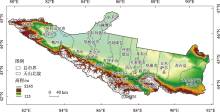
图1
研究区示意图 注:底图采用自然资源部标准地图制作,审图号为GS(2022)4299,对底图边界无修改,下同。"

表1
数据来源"
| 数据类型 | 数据名称 | 分辨率 | 数据来源 |
|---|---|---|---|
| 地形 | DEM | 30 m | 地理空间数据云( |
| 坡度 | 在ArcGIS中基于DEM数据,采用“坡度”工具获取 | ||
| 气候 | 年平均气温 | 1 km | 国家青藏高原科学数据中心( |
| 年平均降水 | |||
| NDVI | 30 m | 科学数据银行( | |
| 经济 | 人口密度 | 1 km | WorldPop数据集( |
| GDP | 中国科学院资源环境科学与数据中心( | ||
| 区位 | 到高速公路的距离 | 30 m | OSM数据经ArcGIS“欧氏距离”工具获取( |
| 到国道的距离 | |||
| 到省道的距离 | |||
| 到县道的距离 | |||
| 到铁路的距离 | |||
| 到河流的距离 | |||
| 土地利用数据 | 中国年度土地覆盖数据集( | ||
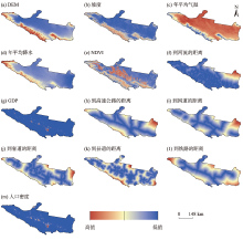
图2
天山北坡2020年土地利用变化潜在驱动因子"

表2
天山北坡不同土地利用类型碳密度"
| 土地利 用类型 | 地上碳密度 | 地下碳密度 | 土壤碳密度 | 死亡有机物碳密度 |
|---|---|---|---|---|
| 耕地 | 51.79 | 61.49 | 7073.94 | 124.00 |
| 林地 | 551.67 | 162.86 | 9956.53 | 248.00 |
| 灌木 | 78.30 | 51.42 | 5895.74 | 80.00 |
| 草地 | 8.71 | 76.58 | 6975.63 | 22.00 |
| 水域 | 11.41 | 8.10 | 0.00 | 0.00 |
| 冰川/积雪 | 0.00 | 0.00 | 0.00 | 0.00 |
| 裸地 | 8.10 | 15.46 | 3559.78 | 0.00 |
| 建设用地 | 40.38 | 25.90 | 0.00 | 0.00 |
| 湿地 | 33.01 | 26.39 | 19640.14 | 0.00 |

图3
天山北坡1990—2020年土地利用转移矩阵(km2)"
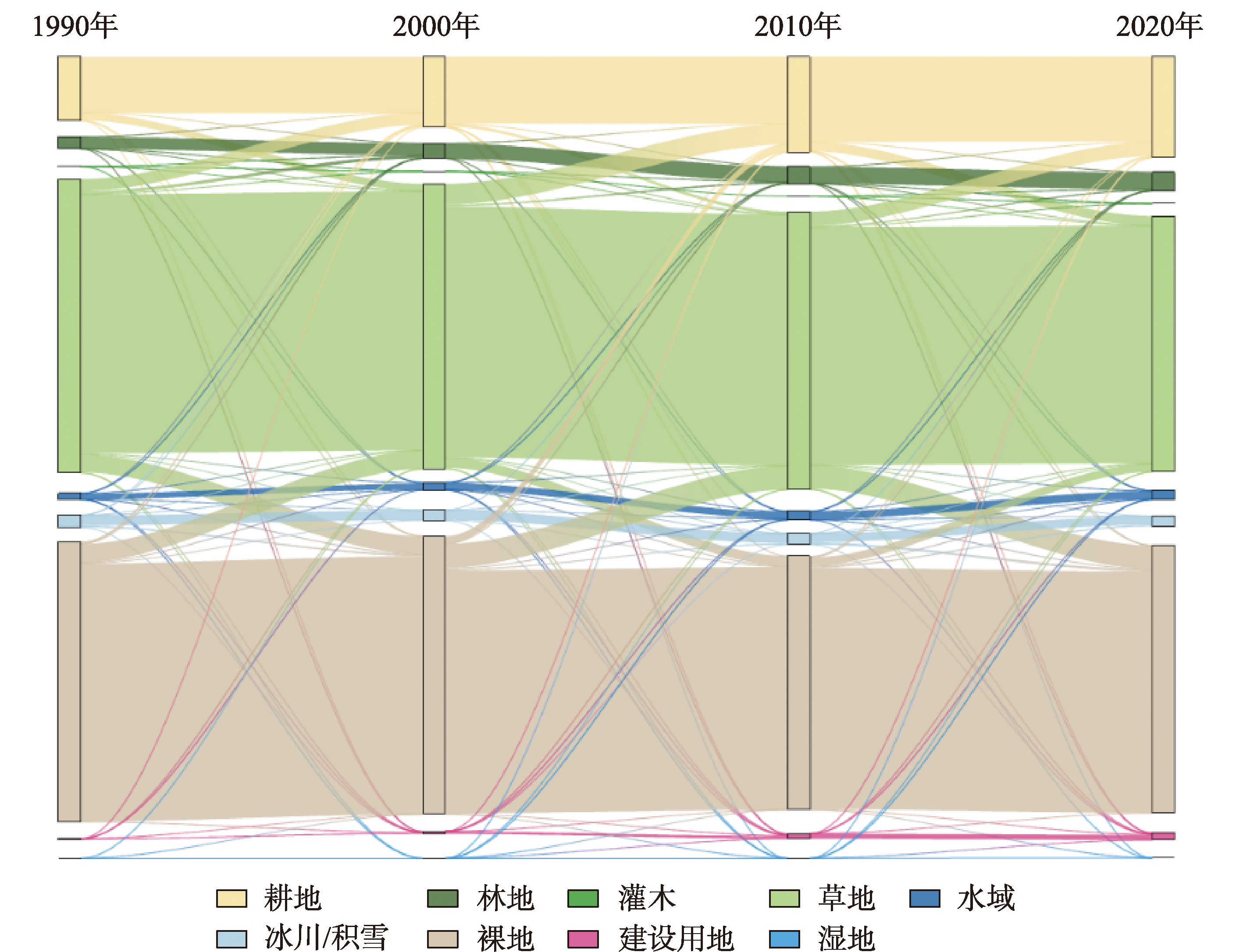
表3
天山北坡1990—2020年不同土地利用类型碳储量"
| 土地利用类型 | 1990年 | 2000年 | 2010年 | 2020年 | 土地利用类型 | 1990年 | 2000年 | 2010年 | 2020年 |
|---|---|---|---|---|---|---|---|---|---|
| 耕地 | 10442.75 | 11510.24 | 15543.89 | 16453.72 | 冰川/积雪 | 0.00 | 0.00 | 0.00 | 0.00 |
| 林地 | 2921.97 | 3667.97 | 4114.96 | 4492.31 | 裸地 | 22373.26 | 22179.95 | 20260.68 | 21359.94 |
| 灌木 | 0.30 | 0.04 | 0.02 | 0.18 | 建设用地 | 1.53 | 3.71 | 7.39 | 10.85 |
| 草地 | 46347.76 | 44970.54 | 43872.70 | 40359.76 | 湿地 | 0.87 | 0.84 | 0.85 | 1.06 |
| 水域 | 2.69 | 3.33 | 3.92 | 3.93 | 总计 | 82091.13 | 82336.62 | 83804.41 | 82681.75 |

图4
天山北坡1990—2020年碳储量空间分布"
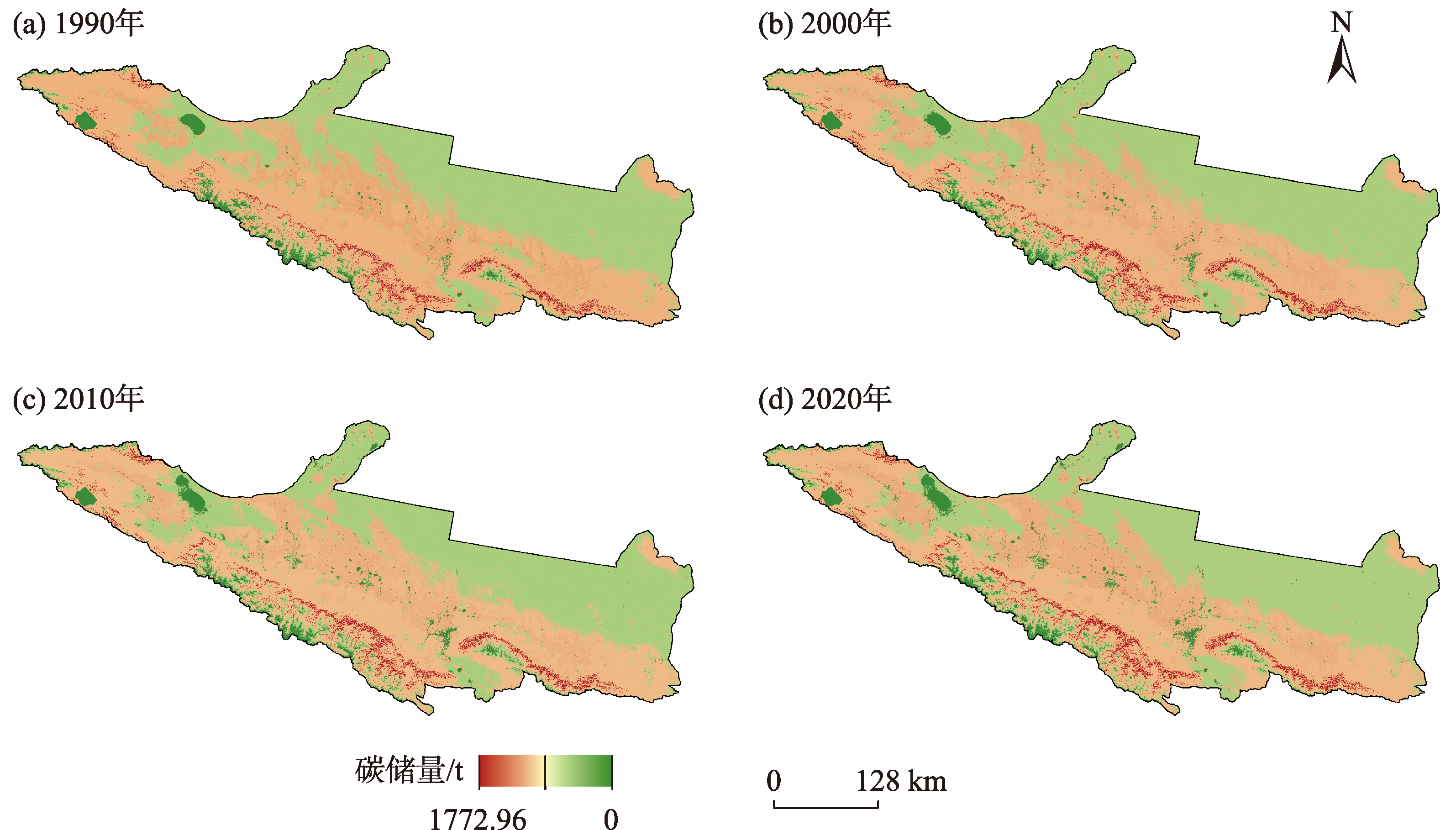
表4
2030年3种情景下预测土地利用类型面积"
| 土地利用类型 | 历史趋势情景 | 水资源保护情景 | 经济发展情景 |
|---|---|---|---|
| 耕地 | 23376.13 | 23360.71 | 23357.68 |
| 林地 | 4433.79 | 4566.95 | 4433.28 |
| 灌木 | 0.36 | 0.45 | 0.44 |
| 草地 | 52969.71 | 52790.99 | 52898.10 |
| 水域 | 2019.50 | 2212.21 | 2013.50 |
| 冰川/积雪 | 2196.84 | 2118.95 | 2202.76 |
| 裸地 | 62061.04 | 61945.84 | 61998.42 |
| 建设用地 | 2078.90 | 2140.16 | 2232.11 |
| 湿地 | 0.64 | 0.64 | 0.64 |
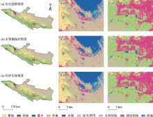
图5
2030年3种情景土地利用预测空间分布"

表5
3种情景下的碳储量及变化(较2020年)"
| 土地利用类型 | 历史趋势情景 | 变化(较2020年) | 水资源保护情景 | 变化(较2020年) | 经济发展情景 | 变化(较2020年) |
|---|---|---|---|---|---|---|
| 耕地 | 17090.80 | 637.09 | 17079.53 | 625.81 | 17077.31 | 623.59 |
| 林地 | 4841.28 | 348.96 | 4986.68 | 494.37 | 4840.72 | 348.41 |
| 灌木 | 0.22 | 0.05 | 0.28 | 0.10 | 0.27 | 0.09 |
| 草地 | 37518.04 | -2841.72 | 37391.45 | -2968.31 | 37467.32 | -2892.44 |
| 水域 | 3.94 | 0.01 | 4.32 | 0.38 | 3.93 | 0.00 |
| 冰川/积雪 | 0.00 | 0.00 | 0.00 | 0.00 | 0.00 | 0.00 |
| 裸地 | 22238.60 | 878.67 | 22197.32 | 837.39 | 22216.16 | 856.23 |
| 建设用地 | 13.78 | 2.93 | 14.18 | 3.34 | 14.79 | 3.95 |
| 湿地 | 1.26 | 0.20 | 1.26 | 0.20 | 1.26 | 0.20 |
| 总计 | 81707.92 | -973.81 | 81675.02 | -1006.72 | 81621.76 | -1059.97 |
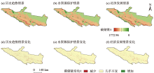
图6
天山北坡2030年碳储量空间分布及变化(较2020年)"

| [1] | Kotlarski S, Gobiet A, Morin S, et al. 21st Century alpine climate change[J]. Climate Dynamics, 2023, 60(1-2): 65-86. |
| [2] | Vera C, Silvestri G, Liebmann B, et al. Climate change scenarios for seasonal precipitation in South America from IPCC-AR4 models[J]. Geophysical Research Letters, 2006, 33(13): L13707. |
| [3] | 张俊峰, 张安录, 董捷. 武汉城市圈土地利用碳排放效应分析及因素分解研究[J]. 长江流域资源与环境, 2014, 23(5): 595-602. |
| [Zhang Junfeng, Zhang Anlu, Dong Jie. Carbon emission effect of land use and influencing factors decomposition of carbon emission in Wuhan Urban Agglomeration[J]. Resources and Environment in the Yangtze Basin, 2014, 23(5): 595-602.] | |
| [4] |
付超, 于贵瑞, 方华军, 等. 中国区域土地利用/覆被变化对陆地碳收支的影响[J]. 地理科学进展, 2012, 31(1): 88-96.
doi: 10.11820/dlkxjz.2012.01.012 |
|
[Fu Chao, Yu Guirui, Fang Huajun, et al. Effects of land use and cover change on terrestrial carbon balance of China[J]. Progress in Geography, 2012, 31(1): 88-96.]
doi: 10.11820/dlkxjz.2012.01.012 |
|
| [5] |
陈广生, 田汉勤. 土地利用/覆盖变化对陆地生态系统碳循环的影响[J]. 植物生态学报, 2007, 31(2): 189-204.
doi: 10.17521/cjpe.2007.0024 |
| [Chen Guangsheng, Tian Hanqin. Land use/cover change effects on carbon cycling in terrestrial ecosystems[J]. Journal of Plant Ecology, 2007, 31(2): 189-204.] | |
| [6] | 韩楚翘, 郑江华, 王哲, 等. 基于PLUS-InVEST模型吐哈盆地陆地生态系统碳储量时空变化及多情景模拟[J]. 干旱区地理, 2024, 47(2): 260-269. |
| [Han Chuqiao, Zheng Jianghua, Wang Zhe, et al. Spatiotemporal variation and multiscenario simulation of carbon storage in terrestrial ecosystems in the Turpan-Hami Basin based on PLUS-InVEST model[J]. Arid Land Geography, 2024, 47(2): 260-269.] | |
| [7] | 田一豆, 赵先超. 基于Markov-PLUS模型的长株潭城市群建设用地扩张模拟及碳排放响应分析[J]. 生态学报, 2024, 44(1): 129-142. |
| [Tian Yidou, Zhao Xianchao. Simulation of construction land expansion and carbon emission response analysis of Changsha-Zhuzhou-Xiangtan Urban Agglomeration based on Markov-PLUS model[J]. Acta Ecologica Sinica, 2024, 44(1): 129-142.] | |
| [8] | 马晓哲, 王铮. 土地利用变化对区域碳源汇的影响研究进展[J]. 生态学报, 2015, 35(17): 5898-5907. |
| [Ma Xiaozhe, Wang Zheng. Progress in the study on the impact of land-use change on regional carbon sources and sinks[J]. Acta Ecologica Sinica, 2015, 35(17): 5898-5907.] | |
| [9] | 张长勤, 徐小琪, 吴坚. 基于系统动力学的土地利用变化研究——以池州市为例[J]. 山东农业大学学报(自然科学版), 2014, 45(1): 110-115. |
| [Zhang Changqin, Xu Xiaoqi, Wu Jian. Study on variation of land using based on ssystem dynamics——Chizhou City taking as example[J]. Journal of Shandong Agricultural University (Natural Science Edition), 2014, 45(1): 110-115.] | |
| [10] | 吴大放, 刘艳艳, 王朝晖. 基于Logistic-CA的珠海市耕地变化机理分析[J]. 经济地理, 2014, 34(1): 140-147. |
| [Wu Dafang, Liu Yanyan, Wang Zhaohui. Mechanism of cultivated land change in Zhuhai City based on a Logistic-CA model[J]. Economic Geography, 2014, 34(1): 140-147.] | |
| [11] | 侯西勇, 常斌, 于信芳. 基于CA-Markov的河西走廊土地利用变化研究[J]. 农业工程学报, 2004, 20(5): 286-291. |
| [Hou Xiyong, Chang Bin, Yu Xinfang. Land use change in Hexi corridor based on CA-Markov methods[J]. Transactions of the Chinese Society of Agricultural Engineering, 2004, 20(5): 286-291.] | |
| [12] |
王旭, 马伯文, 李丹, 等. 基于FLUS模型的湖北省生态空间多情景模拟预测[J]. 自然资源学报, 2020, 35(1): 230-242.
doi: 10.31497/zrzyxb.20200119 |
|
[Wang Xu, Ma Bowen, Li Dan, et al. Multi-scenario simulation and prediction of ecological space in Hubei Province based on FLUS model[J]. Journal of Natural Resources, 2020, 35(1): 230-242.]
doi: 10.31497/zrzyxb.20200119 |
|
| [13] | 李立, 胡睿柯, 李素红. 基于改进FLUS模型的北京市低碳土地利用情景模拟[J]. 自然资源遥感, 2023, 35(1): 81-89. |
| [Li Li, Hu Ruike, Li Suhong. Simulations of the low-carbon land use scenarios of Beijing based on the improved FLUS model[J]. Remote Sensing for Natural Resources, 2023, 35(1): 81-89.] | |
| [14] | 许小亮, 李鑫, 肖长江, 等. 基于CLUE-S模型的不同情景下区域土地利用布局优化[J]. 生态学报, 2016, 36(17): 5401-5410. |
| [Xu Xiaoliang, Li Xin, Xiao Changjiang, et al. Land use layout optimization under different scenarios by using the CLUE-S model[J]. Acta Ecologica Sinica, 2016, 36(17): 5401-5410.] | |
| [15] | 胡丰, 张艳, 郭宇, 等. 基于PLUS和InVEST模型的渭河流域土地利用与生境质量时空变化及预测[J]. 干旱区地理, 2022, 45(4): 1125-1136. |
| [Hu Feng, Zhang Yan, Guo Yu, et al. Spatial and temporal changes in land use and habitat quality in the Weihe River Basin based on the PLUS and InVEST models and predictions[J]. Arid Land Geography, 2022, 45(4): 1125-1136.] | |
| [16] | 林彤, 杨木壮, 吴大放, 等. 基于InVEST-PLUS模型的碳储量空间关联性及预测——以广东省为例[J]. 中国环境科学, 2022, 42(10): 4827-4839. |
| [Lin Tong, Yang Muzhuang, Wu Dafang, et al. Spatial correlation and prediction of land use carbon storage based on the InVEST-PLUS model-A case study in Guangdong Province[J]. China Environmental Science, 2022, 42(10): 4827-4839.] | |
| [17] | 于芝琳, 赵明松, 高迎凤, 等. 基于InVEST-PLUS模型的淮北市碳储量时空演变及预测[J]. 环境科学, 2024, 45(6): 3270-3283. |
| [Yu Zhilin, Zhao Mingsong, Gao Yingfeng, et al. Spatio-temporal evolution and prediction of carbon storage in Huaibei City based on InVEST-PLUS Model[J]. Environmental Science, 2024, 45(6): 3270-3283.] | |
| [18] | 汪勇政, 徐雅利, 余浩然. 基于PLUS-InVEST模型的安徽省碳储量时空变化预测[J]. 水土保持通报, 2023, 43(3): 277-289. |
| [Wang Yongzheng, Xu Yali, Yu Haoran. Prediction of spatial and temporal changes of carbon stocks in Anhui Province based on PLUS-InVEST Model[J]. Bulletin of Soil and Water Conservation, 2023, 43(3): 277-289.] | |
| [19] | 巩晟萱, 张玉虎, 李宇航. 基于PLUS-InVEST模型的京津冀碳储量变化及预测[J]. 干旱区资源与环境, 2023, 37(6): 20-28. |
| [Gong Shengxuan, Zhang Yuhu, Li Yuhang. Spatio-temporal variation and prediction of carbon storage in Beijing-Tianjin-Hebei region: A PLUS-InVEST model approach[J]. Journal of Arid Land Resources and Environment, 2023, 37(6): 20-28.] | |
| [20] | 胡佶熹, 勒先文, 王卫林, 等. 基于PLUS-InVEST模型的江西省生态系统碳储量时空演变与预测[J]. 环境科学, 2024, 45(6): 3284-3296. |
| [Hu Jixi, Le Xianwen, Wang Weilin, et al. Temporal and spatial evolution and prediction of ecosystem carbon storage in Jiangxi Province based on PLUS-InVEST model[J]. Environmental Science, 2024, 45(6): 3284-3296.] | |
| [21] | 孙欣欣, 薛建辉, 董丽娜. 基于PLUS模型和InVEST模型的南京市生态系统碳储量时空变化与预测[J]. 生态与农村环境学报, 2023, 39(1): 41-51. |
| [Sun Xinxin, Xue Jianhui, Dong Lina. Spatiotemporal change and prediction of carbon storage in Nanjing ecosystem based on PLUS model and InVEST model[J]. Journal of Ecology and Rural Environment, 2023, 39(1): 41-51.] | |
| [22] | 智菲, 周振宏, 赵铭, 等. 基于PLUS和InVEST模型的合肥市生态系统碳储量时空演变特征[J]. 水土保持学报, 2024, 38(2): 205-215. |
| [Zhi Fei, Zhou Zhenhong, Zhao Ming, et al. Temporal and spatial evolution characteristics of carbon storage in Hefei ecosystem based on PLUS and InVEST models[J]. Journal of Soil and Water Conservation, 2024, 38(2): 205-215.] | |
| [23] | 卢雅焱, 徐晓亮, 李基才, 等. 基于InVEST模型的新疆天山碳储量时空演变研究[J]. 干旱区研究, 2022, 39(6): 1896-1906. |
| [Lu Yayan, Xu Xiaoliang, Li Jicai, et al. Research on the spatio-temporal variation of carbon storage in the Xinjiang Tianshan Mountains based on the InVEST model[J]. Arid Zone Research, 2022, 39(6): 1896-1906.] | |
| [24] | 张楚强, 向洋, 方婷, 等. LUCC影响下太原市生态系统碳储量时空变化及预测[J]. 安全与环境工程, 2022, 29(6): 248-258. |
| [Zhang Chuqiang, Xiang Yang, Fang Ting, et al. Spatio-temporal evolution and prediction of carbon storage in Taiyuan ecosystem under the influence of LUCC[J]. Safety and Environmental Engineering, 2022, 29(6): 248-258.] | |
| [25] | 史名杰, 武红旗, 贾宏涛, 等. 基于MCE-CA-Markov和InVEST模型的伊犁谷地碳储量时空演变及预测[J]. 农业资源与环境学报, 2021, 38(6): 1010-1019. |
| [Shi Mingjie, Wu Hongqi, Jia Hongtao, et al. Temporal and spatial evolution and prediction of carbon stocks in Yili Valley based on MCE-CA-Markov and InVEST models[J]. Journal of Agricultural Resources and Environment, 2021, 38(6): 1010-1019.] | |
| [26] | 张杰, 李敏, 敖子强, 等. 中国西部干旱区土壤有机碳储量估算[J]. 干旱区资源与环境, 2018, 32(9): 132-137. |
| [Zhang Jie, Li Min, Ao Ziqiang, et al. Estimation of soil organic carbon storage of terrestrial ecosystem in arid western China[J]. Journal of Arid Land Resources and Environment, 2018, 32(9): 132-137.] | |
| [27] | Alam S A, Starr M, Clark B J F. Tree biomass and soil organic carbon densities across the Sudanese woodland savannah: A regional carbon sequestration study[J]. Journal of Arid Environments, 2013, 89: 67-76. |
| [28] | 陈光水, 杨玉盛, 刘乐中, 等. 森林地下碳分配(TBCA)研究进展[J]. 亚热带资源与环境学报, 2007, 2(1): 34-42. |
| [Chen Guangshui, Yang Yusheng, Liu Lezhong, et al. Research review on total belowground carbon allocation in forest ecosystems[J]. Journal of Subtropical Resources and Environment, 2007, 2(1): 34-42.] | |
| [29] | Giardina C P, Ryan M G. Evidence that decomposition rates of organic carbon in mineral soil do not vary with temperature[J]. Nature, 2000, 404(6780): 858-861. |
| [30] | Liang X, Guan Q, Clarke K C, et al. Understanding the drivers of sustainable land expansion using a patch-generating land use simulation (PLUS) model: A case study in Wuhan, China[J]. Computers Environment and Urban Systems, 2021, 85: 101569. |
| [31] | Ling X, Hongwei W, Suhong L. The ecosystem service values simulation and driving force analysis based on land use/land cover: A case study in inland rivers in arid areas of the Aksu River Basin, China[J]. Ecological Indicators, 2022, 138: 108828. |
| [32] |
孙毅中, 杨静, 宋书颖, 等. 多层次矢量元胞自动机建模及土地利用变化模拟[J]. 地理学报, 2020, 75(10): 2164-2179.
doi: 10.11821/dlxb202010009 |
|
[Sun Yizhong, Yang Jing, Song Shuying, et al. Modeling of multilevel vector cellular automata and its simulation of land use change[J]. Acta Geographica Sinica, 2020, 75(10): 2164-2179.]
doi: 10.11821/dlxb202010009 |
|
| [33] | 李佳珂, 邵战林. 基于PLUS和InVEST模型的乌鲁木齐市碳储量时空演变与预测[J]. 干旱区研究, 2024, 41(3): 499-508. |
| [Li Jiake, Shao Zhanlin. Spatiotemporal evolution and prediction of carbon stock in Urumqi City based on PLUS and InVEST models[J]. Arid Zone Research, 2024, 41(3): 499-508.] | |
| [34] | 雒舒琪. 耦合PLUS-INVEST模型的多情景土地利用变化及其对碳储量影响研究[D]. 杨凌: 西北农林科技大学, 2023. |
| [Luo Shuqi. Multi-scenario Land Use Change and Its Impact on Carbon Storage Based on Coupled Plus-Invest Model[D]. Yangling: Northwest A & F University, 2023.] | |
| [35] | 杨潋威, 赵娟, 朱家田, 等. 基于PLUS和InVEST模型的西安市生态系统碳储量时空变化与预测[J]. 自然资源遥感, 2022, 34(4): 175-182. |
| [Yang Lianwei, Zhao Juan, Zhu Jiatian, et al. Spatial-temporal change and prediction of carbon stock in the ecosystem of Xi’an based on PLUS and InVEST models[J]. Remote Sensing for Natural Resources, 2022, 34(4): 175-182.] | |
| [36] |
Zhang R, Liang T, Guo J, et al. Grassland dynamics in response to climate change and human activities in Xinjiang from 2000 to 2014[J]. Scientific Reports, 2018, 8(1): 2888.
doi: 10.1038/s41598-018-21089-3 pmid: 29440664 |
| [37] | 徐自为, 张智杰. 基于土地利用变更调查的2010—2016年新疆尉犁县生态系统碳储量时空变化[J]. 环境科学研究, 2018, 31(11): 1909-1917. |
| [Xu Ziwei, Zhang Zhijie. Spatiotemporal variation of carbon storage in Yuli County during 2010-2016[J]. Research of Environmental Sciences, 2018, 31(11): 1909-1917.] | |
| [38] | 陈宁, 辛存林, 唐道斌, 等. 中国西北地区多情景土地利用优化与碳储量评估[J]. 环境科学, 2023, 44(8): 4655-4665. |
| [Chen Ning, Xin Cunlin, Tang Daobin, et al. Multi-scenario land use optimization and carbon storage assessment in Northwest China[J]. Environmental Science, 2023, 44(8): 4655-4665.] | |
| [39] | Feng X, Fu B, Lu N, et al. How ecological restoration alters ecosystem services: An analysis of carbon sequestration in China’s Loess Plateau[J]. Scientific Reports, 2013, 3(1): 2846. |
| [40] | 吴子豪, 闫庆武, 李桂娥. 资源枯竭型城市转型发展研究[M]. 徐州: 中国矿业大学出版社, 2023. |
| [Wu Zihao, Yan Qingwu, Li Gui’e. Research on the Transformation and Development of Resource-Exhausted Cities[M]. Xuzhou: China University of Mining and Technology Press, 2023.] |
| [1] | 张彬, 郑新军, 王玉刚, 唐立松, 李彦, 杜澜, 田胜川. 1990—2022年天山北坡地区不同开垦年限耕层土壤盐分变化[J]. 干旱区研究, 2024, 41(9): 1435-1445. |
| [2] | 李宇航, 余文学, 杨永均, 朱燕峰, 马静, 陈浮. 近60 a天山北坡经济带天然径流量时空变化及归因识别[J]. 干旱区研究, 2024, 41(9): 1446-1455. |
| [3] | 吴朝巧, 林菲, 牛俊杰, 耿甜伟. 山西中部城市群生态系统服务对土地利用格局变化的响应[J]. 干旱区研究, 2024, 41(7): 1153-1166. |
| [4] | 李冰洁, 范志韬, 曲芷程, 姚顺予, 宿夏姝, 刘东伟, 王立新. 基于InVEST-PLUS模型的黄河流域内蒙古段生态系统碳储量评价及预测[J]. 干旱区研究, 2024, 41(7): 1217-1227. |
| [5] | 李沛尧, 王新军, 许世贤, 高胜寒, 薛智暄, 衡瑞. 基于PLUS土地利用模拟的阿克苏河流域NEP时空格局研究[J]. 干旱区研究, 2024, 41(6): 1059-1068. |
| [6] | 姚小晨, 高凡, 韩方红, 何兵. 2000—2020年阿克苏河流域土地利用强度变化及其对蒸散发的影响[J]. 干旱区研究, 2024, 41(6): 951-963. |
| [7] | 高雅玉, 宋玉, 赵廷红, 高金芳, 何文博, 李泽霞. 马莲河下游产水量时空演变特征[J]. 干旱区研究, 2024, 41(5): 776-787. |
| [8] | 程晓瑜, 吕洁华. 塔里木河流域碳储量的气候影响机制及地形分异下的归因[J]. 干旱区研究, 2024, 41(5): 865-875. |
| [9] | 刘如龙, 赵媛媛, 陈国清, 迟文峰, 刘正佳. 内蒙古黄河流域1990—2020年生境质量评估[J]. 干旱区研究, 2024, 41(4): 674-683. |
| [10] | 李佳珂, 邵战林. 基于PLUS和InVEST模型的乌鲁木齐市碳储量时空演变与预测[J]. 干旱区研究, 2024, 41(3): 499-508. |
| [11] | 严莉, 曹广超, 康利刚, 刘梦琳, 叶得力. 基于InVEST模型的共和县生境质量时空变化及驱动因素[J]. 干旱区研究, 2024, 41(2): 314-325. |
| [12] | 王洋, 冯卓亚, 许丽, 高文信. 塔里木河流域生境质量与土地利用变化响应及驱动力[J]. 干旱区研究, 2024, 41(12): 2132-2142. |
| [13] | 苏泽琛, 邵战林. 干旱区土地利用变化对耕地空间的影响及预测——以昌吉市为例[J]. 干旱区研究, 2024, 41(11): 1936-1945. |
| [14] | 陈春波,李均力,赵炎,夏江,田伟涛,李超锋. 新疆草地时空动态及其对气候变化的响应——以昌吉回族自治州为例[J]. 干旱区研究, 2023, 40(9): 1484-1497. |
| [15] | 申草,任宗萍,李鹏,王凯博,鲁克新,任正龑,魏小燕. 宁夏水土保持生态补偿优先区识别[J]. 干旱区研究, 2023, 40(9): 1527-1536. |
|
||