干旱区研究 ›› 2025, Vol. 42 ›› Issue (8): 1488-1500.doi: 10.13866/j.azr.2025.08.12 cstr: 32277.14.AZR.20250812
刘凤莲1,2( ), 罗芹芹1,3, 杨博文1, 陈洪敏1, 高梓燚4()
收稿日期:2025-04-02
修回日期:2025-06-15
出版日期:2025-08-15
发布日期:2025-11-24
通讯作者:
高梓燚. E-mail: gaozy@ynufe.edu.cn作者简介:刘凤莲(1981-),副教授,主要研究方向为土地利用与可持续发展. E-mail: zz2105@ynufe.edu.cn
基金资助:
LIU Fenglian1,2(), LUO Qinqin1,3, YANG Bowen1, CHEN Hongmin1, GAO Ziyi4()
Received:2025-04-02
Revised:2025-06-15
Published:2025-08-15
Online:2025-11-24
摘要: 泾河流域作为我国西北部生态屏障的重要组成部分,其生态安全至关重要。基于土地利用数据,结合景观格局指数构建景观生态风险评价模型,评估2000—2020年泾河流域景观生态风险时空演变动态特征,并运用地理探测器识别影响流域景观生态风险的关键驱动因子。结果表明:(1) 耕地和草地为流域主要景观类型,两者相互流转较频繁,建设用地呈持续扩张趋势,2000—2020年共增加394.5 km2。(2) 2000—2020年泾河流域的景观生态风险类型以中风险为主,面积占比在41%以上;高风险和中高风险区二者面积占流域面积的1/10左右,沿泾河河网分布,集中分布在地势平坦的中部和东南部;低风险区集中分布在人为干扰较少的东部和西南部。(3) 2000—2020年流域80%以上区域风险等级较稳定,整体上流域景观生态风险降低。(4) 年均气温、GDP密度和高程是影响流域景观生态风险的主要驱动因子;年均气温、年均降水量同其他影响因素交互作用对流域景观生态风险影响显著。
刘凤莲, 罗芹芹, 杨博文, 陈洪敏, 高梓燚. 基于地理探测器的泾河流域景观生态风险及驱动因素[J]. 干旱区研究, 2025, 42(8): 1488-1500.
LIU Fenglian, LUO Qinqin, YANG Bowen, CHEN Hongmin, GAO Ziyi. Landscape ecological risk and driving factors in the Jinghe River Basin based on geodetector analysis[J]. Arid Zone Research, 2025, 42(8): 1488-1500.
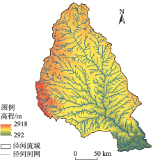
图1
研究区位置示意图"

表1
景观生态风险计算公式"
| 名称 | 公式 | 含义 |
|---|---|---|
| 景观破碎度指数(Pi) | 指景观被分割成不连续、破碎化斑块的程度,是衡量区域景观空间复杂性的重要指标 | |
| 景观分离度指数(Ki) | 指同一类型景观的不同斑块之间在空间上的分离程度,用于反映景观在空间分布上的分散状态 | |
| 景观优势度指数(Ti) | 用于测度整体景观结构中某一景观类型支配其他景观类型的程度,反映景观在生态、美学和社会层面上的优势度 | |
| 景观干扰度指数(Gi) | 用于表示景观生态环境受外界因素活动影响的程度 | |
| 景观脆弱度指数(Wi) | 建设用地赋值为1,林地为2,草地为3,耕地为4,水域为5,未利用地为6,进行归一化处理 | 指用于衡量景观系统对外界干扰的敏感性和恢复能力 |
| 景观损失度指数(Xi) | Xi=Gi×Wi | 指景观生态系统在受到外界因素影响后受损状况和恢复能力的强弱 |

图2
2000—2020年泾河流域土地利用时空演变"

图3
泾河流域土地利用流转情况"


图4
2000—2020年泾河流域景观生态风险面积变化"


图5
泾河流域景观生态风险时空演变"

表2
泾河流域景观生态风险变化趋势"
| 变化趋势 | 2000—2010年 | 2010—2020年 | 2000—2020年 | |||||
|---|---|---|---|---|---|---|---|---|
| 面积/km2 | 占比/% | 面积/km2 | 占比/% | 面积/km2 | 占比/% | |||
| 稳定 | 3.83×10⁴ | 82.35 | 4.13×10⁴ | 88.71 | 3.74×10⁴ | 80.24 | ||
| 升高 | 924.81 | 1.99 | 2681.24 | 5.74 | 1725.17 | 3.71 | ||
| 降低 | 7022.51 | 15.07 | 2080.93 | 4.47 | 6888.20 | 14.78 | ||
| 显著升高 | 172.30 | 0.37 | 398.68 | 0.86 | 396.27 | 0.85 | ||
| 显著降低 | 101.91 | 0.22 | 100.56 | 0.22 | 196.07 | 0.42 | ||

图6
泾河流域景观生态风险等级变化"
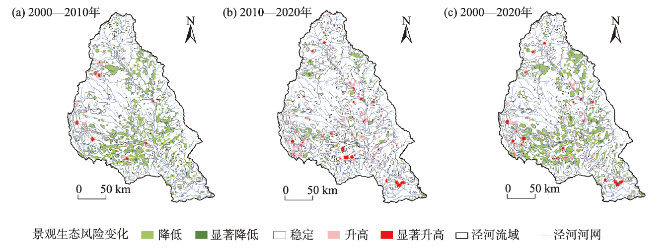
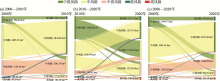
图7
2000—2020年泾河流域风险变化冲积图"

表3
景观生态风险驱动因素单因子探测结果"
| 影响因素 | 因子/序号 | 贡献度/% | ||||
|---|---|---|---|---|---|---|
| 2000年 | 2005年 | 2010年 | 2015年 | 2020年 | ||
| 自然因素 | 高程(X1) | 17.23 | 22.09 | 22.31 | 19.86 | 20.66 |
| NDVI(X2) | 6.56 | 7.06 | 5.61 | 6.37 | 2.37 | |
| 年均降水量(X3) | 5.54 | 5.98 | 7.90 | 8.03 | 13.34 | |
| 年均气温(X4) | 19.56 | 24.57 | 25.53 | 23.03 | 24.48 | |
| 社会经济因素 | 人口密度(X5) | 1.60 | 5.08 | 5.71 | 5.33 | 7.65 |
| 夜间灯光(X6) | 19.19 | 8.31 | 6.46 | 5.29 | 5.99 | |
| GDP密度(X7) | 21.50 | 18.27 | 18.70 | 18.54 | 18.44 | |
| 人为干扰度(X8) | 8.82 | 8.64 | 7.78 | 13.55 | 7.07 | |
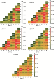
图8
2000—2020年泾河流域景观生态风险驱动因子交互作用探测结果"

| [1] |
杨荣钦, 肖玉磊, 池苗苗, 等. 近20 a塔里木河流域人类活动及景观生态风险时空变化[J]. 干旱区研究, 2024, 41(6): 1010-1020.
doi: 10.13866/j.azr.2024.06.10 |
|
[Yang Rongqin, Xiao Yulei, Chi Miaomiao, et al. Temporal and spatial variations of human activities and landscape ecological risks in the Tarim River Basin, China, during the last 20 years[J]. Arid Zone Research, 2024, 41(6): 1010-1020.]
doi: 10.13866/j.azr.2024.06.10 |
|
| [2] | 刘纪远, 匡文慧, 张增祥, 等. 20世纪80年代末以来中国土地利用变化的基本特征与空间格局[J]. 地理学报, 2014, 69(1): 3-14. |
|
[Liu Jiyuan, Kuang Wenhui, Zhang Zengxiang, et al. Spatiotemporal characteristics, patterns and causes of land use changes in China since the late 1980s[J]. Acta Geographica Sinica, 2014, 69(1): 3-14.]
doi: 10.11821/dlxb201401001 |
|
| [3] |
彭建, 党威雄, 刘焱序, 等. 景观生态风险评价研究进展与展望[J]. 地理学报, 2015, 70(4): 664-677.
doi: 10.11821/dlxb201504013 |
|
[Peng Jian, Dang Weixiong, Liu Yanxu, et al. Review on landscape ecological risk assessment[J]. Acta Geographica Sinica, 2015, 70(4): 664-677.]
doi: 10.11821/dlxb201504013 |
|
| [4] |
Bao T T, Wang R F, Song L H, et al. Spatio-temporal multi-scale analysis of landscape ecological risk in Minjiang River Basin based on adaptive cycle[J]. Remote Sensing, 2022, 14(21): 5540.
doi: 10.3390/rs14215540 |
| [5] |
Landis W G. Ecological risk assessment conceptual model formulation for nonindigenous species[J]. Risk Analysis : An International Journal, 2004, 24(4): 847-858.
doi: 10.1111/risk.2004.24.issue-4 |
| [6] |
Ayre K K, Landis G W. A Bayesian approach to landscape ecological risk assessment applied to the upper Grande Ronde Watershed, Oregon[J]. Human and Ecological Risk Assessment: An International Journal, 2012, 18(5): 946-970.
doi: 10.1080/10807039.2012.707925 |
| [7] |
Malandra F, Vitali A, Urbinati C, et al. Patterns and drivers of forest landscape change in the Apennines range, Italy[J]. Regional Environmental Change, 2019, 19(7): 1973-1985.
doi: 10.1007/s10113-019-01531-6 |
| [8] | 田雅楠, 马龙, 吴全. 黄河流域内蒙古段土地利用演变与景观生态风险评价[J]. 生态科学, 2023, 42(5): 103-113. |
| [Tian Ya nan, Ma Long, Wu Quan. Landscape ecological risk assessment in Inner Mongolia reaches of Yellow River based on land use evolution[J]. Ecological Science, 2023, 42(5): 103-113.] | |
| [9] |
马颖忆, 刘志峰. 江苏省景观生态风险评估及其与城镇化的动态响应[J]. 南京林业大学学报(自然科学版), 2021, 45(5): 185-194.
doi: 10.12302/j.issn.1000-2006.202008049 |
| [Ma Yingyi, Liu Zhifeng. Assessment of landscape ecological risk and its dynamic response with urbanization development of Jiangsu Province[J]. Journal of Nanjing Forestry University (Natural Sciences Edition), 2021, 45(5): 185-194.] | |
| [10] |
高彬嫔, 李琛, 吴映梅, 等. 川滇生态屏障区景观生态风险评价及影响因素[J]. 应用生态学报, 2021, 32(5): 1603-1613.
doi: 10.13287/j.1001-9332.202105.018 |
|
[Gao Binpin, Li Chen, Wu Yingmei, et al. Landscape ecological risk assessment and influencing factors in ecological conservation area in Sichuan-Yunnan Provinces, China[J]. Chinese Journal of Applied Ecology, 2021, 32(5): 1603-1613.]
doi: 10.13287/j.1001-9332.202105.018 |
|
| [11] | 刘敏, 蔡海生, 张学玲, 等. 基于Geodetector-GTWR的江西省景观生态风险及驱动因素[J/OL]. 环境科学, [2025-03-19]. https://doi.org/10.13227/j.hjkx.202409113. |
| [Liu Min, Cai Haisheng, Zhang Xueling, et al. Landscape ecological risk and its driving factors in Jiangxi Province based on Geodetector-GTWR[J/OL]. Environmental Science, [2025-03-19]. https://doi.org/10.13227/j.hjkx.202409113.] | |
| [12] | 杜佳衡, 王影雪, 潘悦, 等. 高原河谷县域景观生态风险评价与生态安全格局构建——以云南省大理州永平县为例[J]. 生态学杂志, 2024, 43(5): 1509-1520. |
|
[Du Jiaheng, Wang Yingxue, Pan Yue, et al. Ecological risk assessment and ecological security pattern construction of county-level landscape in plateau valley: A case study in Yongping County, Dali Prefecture, Yunnan Province[J]. Chinese Journal of Ecology, 2024, 43(5): 1509-1520.]
doi: 10.13292/j.1000-4890.202405.046 |
|
| [13] | 钟祺康, 王志一, 王娜, 等. 陕北干旱区景观生态风险空间分异特征及驱动因素分析[J]. 测绘通报, 2022, 28(7):100-106. |
| [Zhong Qikang, Wang Zhiyi, Wang Na, et al. Spatial differentiation characteristics and driving factors of landscape ecological risk in arid area of northern Shaanxi[J]. Bulletin of Surveying and Mapping, 2022, 28(7): 100-106.] | |
| [14] | 刘迪, 陈海, 张敏, 等. 生态脆弱区景观生态风险时空分异及其地形梯度分析——以陕西省米脂县为例[J]. 水土保持研究, 2019, 26(4): 239-244, 251. |
| [Liu Di, Chen Hai, Zhang Min, et al. Analysis of spatial-temporal distribution of landscape ecological risk in ecologically vulnerable areas and its terrain gradient: A case study of Mizhi County of Shaanxi Province[J]. Research of Soil and Water Conservation, 2019, 26(4): 239-244, 251.] | |
| [15] | 宋昌素, 王育哲. 党的二十大以来习近平生态文明思想研究述评[J]. 中国井冈山干部学院学报, 2025, 18(1): 138-144. |
| [Song Changsu, Wang Yuzhe. Review on the research of Xi Jinping’s thought on ecological civilization since the 20th National Congress of the CPC[J]. Journal of China Executive Leadership Academy Jinggangshan, 2025, 18(1): 138-144.] | |
| [16] | 刘可暄, 王冬梅, 魏源送, 等. 密云水库流域多尺度景观生态风险时空演变趋势[J]. 生态学报, 2023, 43(1): 105-117. |
| [Liu Kexuan, Wang Dongmei, Wei Yuansong, et al. Spatio-temporal evolution trend of multi-scale landscape ecological risk in Miyun Reservoir Watershed[J]. Acta Ecologica Sinica, 2023, 43(1): 105-117.] | |
| [17] |
苏海民, 何爱霞. 基于RS和地统计学的福州市土地利用分析[J]. 自然资源学报, 2010, 25(1): 91-99.
doi: 10.11849/zrzyxb.2010.01.010 |
|
[Su Haimin, He Aixia. Analysis of land use based on RS and geostatistics in Fuzhou City[J]. Journal of Natural Resources, 2010, 25(1): 91-99.]
doi: 10.11849/zrzyxb.2010.01.010 |
|
| [18] | 王舒, 刘凤莲, 陈威廷, 等. 滇中高原湖泊流域景观生态风险评价及驱动因素识别[J]. 中国生态农业学报(中英文), 2024, 32(3):391-404. |
| [Wang Shu, Liu Fenglian, Chen Weiting, et al. Landscape ecological risk evaluation and driving factors in the lake basin of Central Yunnan Plateau[J]. Chinese Journal of Eco-Agriculture, 2024, 32(3): 391-404.] | |
| [19] |
张学斌, 石培基, 罗君, 等. 基于景观格局的干旱内陆河流域生态风险分析——以石羊河流域为例[J]. 自然资源学报, 2014, 29(3): 410-419.
doi: 10.11849/zrzyxb.2014.03.005 |
|
[Zhang Xuebin, Shi Peiji, Luo Jun, et al. The ecological risk assessment of arid inland river basin at the landscape scale: A case study on Shiyang River Basin[J]. Journal of Natural Resources, 2014, 29(3): 410-419.]
doi: 10.11849/zrzyxb.2014.03.005 |
|
| [20] |
王劲峰, 徐成东. 地理探测器: 原理与展望[J]. 地理学报, 2017, 72(1): 116-134.
doi: 10.11821/dlxb201701010 |
|
[Wang Jinfeng, Xu Chendong. Geodetectors: Principles and prospects[J]. Acta Geographica Sinica, 2017, 72(1): 116-134.]
doi: 10.11821/dlxb201701010 |
|
| [21] |
孙丽蓉, 周冬梅, 岑国璋, 等. 基于地理探测器模型的疏勒河流域景观生态风险评价及驱动因素分析[J]. 干旱区地理, 2021, 44(5): 1384-1395.
doi: 10.12118/j.issn.1000–6060.2021.05.19 |
|
[Sun Lirong, Zhou Dongmei, Ceng Guozhang, et al. Landscape ecological risk assessment and driving factors of the Shule River Basin based on the geographic detector model[J]. Arid Land Geography, 2021, 44(5): 1384-1395.]
doi: 10.12118/j.issn.1000–6060.2021.05.19 |
|
| [22] |
余玉洋, 李晶, 周自翔, 等. 基于贝叶斯网络的生态系统服务空间格局优化——以泾河流域为例[J]. 干旱区地理, 2022, 45(4):1268-1280.
doi: 10.12118/j.issn.1000-6060.2021.465 |
|
[Yu Yuyang, Li Jing, Zhou Zixiang, et al. Spatial pattern optimization of ecosystem services based on Bayesian networks: A case of the Jing River Basin[J]. Arid Land Geography, 2022, 45(4): 1268-1280.]
doi: 10.12118/j.issn.1000-6060.2021.465 |
|
| [23] | 樊凯瑄, 周自翔, 付媛, 等. 黄土高原中部泾河流域景观生态韧性动态特征[J]. 地球科学与环境学报, 2023, 45(6): 1299-1315. |
| [Fan Kaixuan, Zhou Zixiang, Fu Yuan, et al. Dynamic characteristics of landscape ecological resilience in Jinghe River Basin, the middle of Loess Plateau, China[J]. Journal of Earth Sciences and Environment, 2023, 45(6): 1299-1315.] | |
| [24] |
Karimian H, Zou W, Chen Y, et al. Landscape ecological risk assessment and driving factor analysis in Dongjiang River Watershed[J]. Chemosphere, 2022, 307: 135835.
doi: 10.1016/j.chemosphere.2022.135835 |
| [28] | [Gao Lin, Zhao Zhongqiu, Song Dongyang, et al. Evolution of landscape ecological risk and its response to natural and anthropogenic factors: A case study of ecological conservation area in Beijing[J]. China Environmental Science, 2024, 44(7):4031-4041.] |
| [29] | 张师赫, 李宝银, 林玉英, 等. 基于生态系统服务的景观生态风险评价及其驱动因素研究——以福建省为例[J]. 水土保持研究, 2022, 29(6): 174-182. |
| [Zhang Shihe, Li Baoyin, Lin Yuying, et al. Research on landscape ecological risk assessment and driving factors based on ecosystem services: A case study of Fujian Province[J]. Region Research of Soil and Water Conservation, 2022, 29(6): 174-182.] | |
| [30] | 罗芹芹, 刘凤莲. 赤水河流域(贵州段)景观生态风险时空演变及驱动力探索[J]. 中国生态农业学报(中英文), 2025, 33(3): 550-562. |
| [Luo Qinqin, Liu Fenglian. Spatial-temporal evolution and driving forces of landscape ecological risk in the Chishui River Basin (Guizhou section)[J]. Chinese Journal of Eco-Agriculture, 2025, 33(3): 550-562.] | |
| [25] | 耿艳辉, 吕爱锋, 闵庆文, 等. 泾河流域不同时期土壤侵蚀状况及分区的植被建设研究[J]. 干旱区研究, 2012, 29(3): 385-392. |
| [Geng Yanhui, Lü Aifeng, Min Qingwen, et al. Research on soil erosion and regional differentiation of forestland in the Jinghe Watershed[J]. Arid Zone Research, 2012, 29(3): 385-392.] | |
| [26] |
修炀景, 侯蒙京, 田骄阳, 等. 基于土地利用/覆盖的甘肃省景观生态风险时空变化特征[J]. 草业学报, 2023, 32(1): 1-15.
doi: 10.11686/cyxb2021298 |
|
[Xiu Yangjing, Hou Mengjing, Tian Jiaoyang, et al. Characteristics of temporal and spatial variation in landscape ecological risk in Gansu Province based on land use and cover[J]. Acta Prataculturae Sinica, 2023, 32(1): 1-15.]
doi: 10.11686/cyxb2021298 |
|
| [27] | 于婧, 汤昪, 陈艳红, 等. 山水资源型城市景观生态风险评价及生态安全格局构建——以张家界市为例[J]. 生态学报, 2022, 42(4): 1290-1299. |
| [Yu Jing, Tang Bian, Chen Yanhong, et al. Landscape ecological risk assessment and ecological security pattern construction in landscape resource-based city: A case study of Zhangjiajie City[J]. Acta Ecologica Sinica, 2022, 42(4): 1290-1299.] | |
| [28] | 高林, 赵中秋, 宋东阳, 等. 景观生态风险演变及其对驱动因素的响应——以北京生态涵养区为例[J]. 中国环境科学, 2024, 44(7): 4031-4041. |
| [1] | 陈珍, 蔡朝朝, 马楠, 戴硕, 王震鲁. 2001—2023年新疆NDVI时空格局与驱动力分析[J]. 干旱区研究, 2025, 42(5): 922-932. |
| [2] | 张艳, 杨维新, 吕韬. 基于GeoDetector-MCCA的土地利用变化驱动因素分析与多情景模拟——以黄河流域甘肃段为例[J]. 干旱区研究, 2025, 42(4): 668-681. |
| [3] | 张起鹏, 路红娥, 赵頔琛, 卓玛兰草. 甘南黄河上游植被覆盖度时空变化与地形因子的关系[J]. 干旱区研究, 2025, 42(3): 523-522. |
| [4] | 巩小维, 周冬梅, 张军, 罗世玉, 陈建坤, 高雅娟. “三生空间”视角下庆阳市景观生态风险评价及耦合协调度[J]. 干旱区研究, 2025, 42(3): 556-567. |
| [5] | 张擂, 周煜明, 董杰谋, 李祥, 刘时栋, 徐丽萍. 中国耕地非农化与非粮化时空分异及其治理策略[J]. 干旱区研究, 2025, 42(2): 372-383. |
| [6] | 白松竹, 姚俊强, 马依拉古丽, 李岩瑛, 马幸蔚, 杜江. 吐哈地区沙尘天气时空演变特征及气候影响因子[J]. 干旱区研究, 2025, 42(10): 1791-1801. |
| [7] | 吕宁, 国语, 彭琴, 尹飞虎, 张嘉淇, 刘杏认, 曾梅, 许子函. 新疆耕地利用碳源/汇效应时空演变特征及其贡献因子[J]. 干旱区研究, 2025, 42(1): 179-190. |
| [8] | 张文睿, 孙栋元, 王亦可, 杨俊, 兰立军, 靳虎甲, 徐裕. 河西走廊水资源-生态环境-社会经济系统耦合关系及时空分异[J]. 干旱区研究, 2024, 41(9): 1527-1537. |
| [9] | 李可璇, 张蕾, 李豪, 张恩月, 李育桢, 宋彩云, 刘庚. 基于MSPA模型和电路理论的晋西北国土空间生态修复关键区域识别[J]. 干旱区研究, 2024, 41(9): 1593-1604. |
| [10] | 高鹏程, 岳艳妮, 鄢继选, 王世杰, 别强. 甘南藏族自治州土地利用与生态风险时空演变及驱动因素[J]. 干旱区研究, 2024, 41(7): 1140-1152. |
| [11] | 菅政博, 罗浩, 单娜娜. “双碳”目标下新疆“三生”空间时空演变特征及碳效应[J]. 干旱区研究, 2024, 41(7): 1238-1248. |
| [12] | 杨荣钦, 肖玉磊, 池苗苗, 穆振侠. 近20 a塔里木河流域人类活动及景观生态风险时空变化[J]. 干旱区研究, 2024, 41(6): 1010-1020. |
| [13] | 周建伟, 罗君, 马雪洋. 拉萨河流域土地利用与生态系统服务价值时空演变及驱动因素[J]. 干旱区研究, 2024, 41(6): 1021-1031. |
| [14] | 侯嘉烨, 李建华, 王佳蓉, 马海涛, 强泽楷, 樊新刚. 基于SA-RSEI模型的盐池县生态质量演变研究[J]. 干旱区研究, 2024, 41(6): 1045-1058. |
| [15] | 唐可欣, 郭建斌, 何亮, 陈林, 万龙. 中国旱区GPP时空演变特征及影响因素研究[J]. 干旱区研究, 2024, 41(6): 964-973. |
|
||