干旱区研究 ›› 2025, Vol. 42 ›› Issue (1): 154-165.doi: 10.13866/j.azr.2025.01.14 cstr: 32277.14.AZR.20250114
张莹1( ), 赵媛媛1(), 刘如龙1, 王岳, 丁国栋1
收稿日期:2024-07-14
修回日期:2024-09-18
出版日期:2025-01-15
发布日期:2025-01-17
通讯作者:
赵媛媛. E-mail: yuanyuan0402@bjfu.edu.cn作者简介:张莹(1999-),女,硕士研究生,主要从事荒漠化防治研究. E-mail: 2770981924@qq.com
基金资助:
ZHANG Ying1(), ZHAO Yuanyuan1(), LIU Rulong1, WANG Yue, DING Guodong1
Received:2024-07-14
Revised:2024-09-18
Published:2025-01-15
Online:2025-01-17
摘要:
探究脆弱区生境质量变化过程及未来情景格局对于研究区生态环境科学保护具有重要意义。本研究基于土地利用数据、FLUS-InVEST模型及空间自相关方法,分析中国北方农牧交错带2000—2020年生境质量时空格局,并对2040年生境质量进行多情景模拟。结果表明:(1) 草地是研究区的主要土地类型,占比超过41%。2000—2020年研究区耕地变化最为显著,面积减少10157 km2,林地和建设用地面积有所增加。(2) 研究区东南边界生境质量相对较高;2000—2020年平均生境质量变化不大,但生境质量较低等级和较高等级的面积分别增加2281 km2和1375 km2,退化度较高的研究区则呈现为点状集中分布在部分建设用地上。(3) 2040年各情景下生境质量呈现出向好趋势,但生态保护情景下生境质量提升最为显著,较高等级面积较2020年增加2514 km2。建议未来土地利用规划和生态环境保护过程中,需重点关注内蒙古东南部、河北北部等生境质量低的区域。
张莹, 赵媛媛, 刘如龙, 王岳, 丁国栋. 中国北方农牧交错带生境质量时空演变与情景模拟[J]. 干旱区研究, 2025, 42(1): 154-165.
ZHANG Ying, ZHAO Yuanyuan, LIU Rulong, WANG Yue, DING Guodong. Spatiotemporal evolution and scenario simulation of habitat quality in the agro-pastoral ecotone of northern China[J]. Arid Zone Research, 2025, 42(1): 154-165.
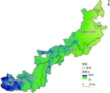
图1
研究区地理位置 注:底图采用自然资源部标准地图制作,审图号为GS(2019)1822号,对底图边界无修改。下同。"

表1
生境威胁因子的影响范围及其权重"
| 威胁源 | 权重 | 最大影响距离/km | 衰退类型 |
|---|---|---|---|
| 耕地 | 0.21 | 2 | 线性衰退 |
| 城乡居民点 | 0.32 | 5 | 指数衰退 |
| 未利用地 | 0.32 | 10 | 线性衰退 |
表2
不同威胁因子下生境适宜性以及相对敏感度"
| 土地利用类型 | 生境适宜度 | 敏感度 | ||
|---|---|---|---|---|
| 耕地 | 城乡居民点 | 未利用地 | ||
| 耕地 | 0.5 | 0.3 | 0.4 | 0.3 |
| 林地 | 0.9 | 0.6 | 0.8 | 0.8 |
| 草地 | 0.5 | 0.5 | 0.55 | 0.6 |
| 水域 | 0.8 | 0.7 | 0.8 | 0.9 |
| 城乡居民点 | 0 | 0 | 0 | 5 |
| 未利用地 | 0 | 0 | 0 | 0 |
表3
四种情景下土地利用类型限制转移矩阵设置"
| 类型 | 趋势发展 | 经济发展 | |||||||||||
|---|---|---|---|---|---|---|---|---|---|---|---|---|---|
| 耕地 | 林地 | 草地 | 水域 | 建设用地 | 未利用地 | 耕地 | 林地 | 草地 | 水域 | 建设用地 | 未利用地 | ||
| 耕地 | 1 | 0 | 1 | 0 | 1 | 1 | 1 | 0 | 1 | 0 | 1 | 1 | |
| 林地 | 0 | 1 | 1 | 0 | 1 | 1 | 1 | 1 | 1 | 0 | 0 | 0 | |
| 草地 | 1 | 1 | 1 | 1 | 1 | 1 | 1 | 1 | 1 | 1 | 1 | 1 | |
| 水域 | 0 | 1 | 1 | 1 | 1 | 1 | 1 | 0 | 1 | 1 | 0 | 1 | |
| 建设用地 | 1 | 0 | 1 | 0 | 1 | 1 | 0 | 0 | 0 | 0 | 1 | 0 | |
| 未利用地 | 1 | 1 | 1 | 0 | 1 | 1 | 1 | 1 | 1 | 0 | 1 | 1 | |
| 类型 | 耕地保护 | 生态保护 | |||||||||||
| 耕地 | 林地 | 草地 | 水域 | 建设用地 | 未利用地 | 耕地 | 林地 | 草地 | 水域 | 建设用地 | 未利用地 | ||
| 耕地 | 1 | 0 | 0 | 0 | 0 | 0 | 1 | 0 | 0 | 0 | 0 | 0 | |
| 林地 | 1 | 1 | 1 | 0 | 0 | 1 | 0 | 1 | 0 | 0 | 0 | 0 | |
| 草地 | 1 | 1 | 1 | 0 | 1 | 1 | 0 | 1 | 1 | 1 | 0 | 0 | |
| 水域 | 1 | 0 | 0 | 1 | 0 | 1 | 0 | 0 | 0 | 1 | 0 | 0 | |
| 建设用地 | 0 | 0 | 0 | 0 | 1 | 0 | 0 | 0 | 0 | 0 | 1 | 0 | |
| 未利用地 | 1 | 1 | 1 | 1 | 1 | 1 | 1 | 1 | 1 | 1 | 1 | 1 | |
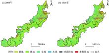
图2
2000年和2020年北方农牧交错带土地利用分布"

表4
2000—2020年北方农牧交错带土地利用类型面积转移矩阵"
| 2000年 | 2020年 | |||||
|---|---|---|---|---|---|---|
| 耕地 | 林地 | 草地 | 水域 | 建设用地 | 未利用地 | |
| 耕地 | 206085 | 6804 | 16922 | 810 | 5610 | 871 |
| 林地 | 3359 | 99784 | 4880 | 175 | 722 | 186 |
| 草地 | 13991 | 9789 | 263569 | 445 | 2874 | 2354 |
| 水域 | 852 | 178 | 340 | 9226 | 152 | 1185 |
| 建设用地 | 1226 | 170 | 323 | 37 | 11859 | 46 |
| 未利用地 | 1436 | 273 | 2873 | 288 | 537 | 35977 |
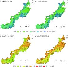
图3
2000—2020年北方农牧交错带的生境质量与生境退化度的时空变化"

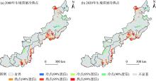
图4
2000—2020年北方农牧交错带生境质量冷热点"

表5
2020年和2040年各情景下北方农牧交错带土地利用类型面积"
| 土地利用类型 | 2020年 | 2040年 | |||
|---|---|---|---|---|---|
| 趋势发展 | 生态保护 | 经济发展 | 耕地保护 | ||
| 耕地 | 226956 | 223700 | 227286 | 223700 | 227146 |
| 林地 | 117012 | 100628 | 119175 | 104986 | 101452 |
| 草地 | 288918 | 306667 | 288756 | 306665 | 306665 |
| 水域 | 10983 | 10578 | 10985 | 10886 | 10968 |
| 建设用地 | 21756 | 26424 | 21791 | 21756 | 21761 |
| 未利用地 | 40619 | 38247 | 38251 | 38251 | 38252 |
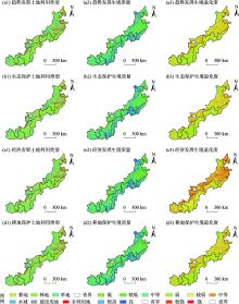
图5
2040年北方农牧交错带土地利用类型、生境质量及生境退化度"

表6
2020年和2040年各情景下北方农牧交错带不同等级的生境质量面积"
| 生境质量 | 2020年 | 2040年 | |||
|---|---|---|---|---|---|
| 趋势发展 | 生态保护 | 经济发展 | 耕地保护 | ||
| 低 | 62375 | 64671 | 60042 | 60007 | 60013 |
| 较低 | 144609 | 105034 | 107312 | 145490 | 107416 |
| 中等 | 380003 | 438444 | 423420 | 392848 | 439357 |
| 较高 | 24608 | 25162 | 27122 | 22523 | 23719 |
| 高 | 94649 | 72933 | 88348 | 85376 | 75739 |
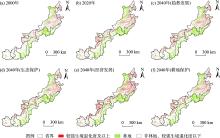
图6
北方农牧交错带在较强生境退化程度下与林地的分布特征关系"

| [1] | 赵哈林, 周瑞莲, 张铜会, 等. 我国北方农牧交错带的草地植被类型、特征及其生态问题[J]. 中国草地, 2003, 25(3): 2-9. |
| [Zhao Halin, Zhou Ruilian, Zhang Tonghui, et al. Grassland vegetation types characteristics and ecological problems in the agriculture-pastoral ecotone in northern China[J]. Grassland in China, 2003, 25(3): 2-9. ] | |
| [2] | 苏志珠, 马义娟, 刘梅. 中国北方农牧交错带形成之探讨[J]. 山西大学学报(自然科学版), 2003, 26(3): 269-273. |
| [Su Zhizhu, Ma Yijuan, Liu Mei. Study on the formation of transitional belt between agriculture and animal husbandry in northern China[J]. Journal of Shanxi University (Natural Science Edition), 2003, 26(3): 269-273. ] | |
| [3] | 崔潇, 王永生, 施琳娜. 北方农牧交错带人地系统耦合协调的时空特征及障碍因子[J]. 农业资源与环境学报, 2023, 40(1): 206-217. |
| [Cui Xiao, Wang Yongsheng, Shi Linna. Spatio-temporal characteristics and obstacle factors of human-land system coupling coordination in farming pastoral ecotone of northern China[J]. Journal of Agricultural Resources and Environment, 2023, 40(1): 206-217. ] | |
| [4] |
任涵, 张静静, 朱文博, 等. 太行山淇河流域土地利用变化对生境的影响[J]. 地理科学进展, 2018, 37(12): 1693-1704.
doi: 10.18306/dlkxjz.2018.12.011 |
| [Ren Han, Zhang Jingjing, Zhu Wenbo, et al. Impact of land use change on habitat in the Qihe River Basin of Taihang Mountains[J]. Advances in Geography Science, 2018, 37(12): 1693-1704. ] | |
| [5] | Ray T C, Dickson G B, Sisk D T, et al. Spatial application of a predictive wildlife occurrence model to assess alternative forest management scenarios in northern Arizona[J]. Forest Ecology and Management, 2014, 322(39): 117-126. ] |
| [6] | 吴健生, 曹祺文, 石淑芹, 等. 基于土地利用变化的京津冀生境质量时空演变[J]. 应用生态学报, 2015, 26(11): 3457-3466. |
|
[Wu Jiansheng, Cao Qiwen, Shi Shuqin, et al. Spatio-temporal variability of habitat quality in Beijing-Tianjin-Hebei Area based on land use change[J] Chinese Journal of Applied Ecology, 2015, 26(11): 3457-3466. ]
pmid: 26915203 |
|
| [7] | Dai L, Li S, Lewis B J, et al. The influence of land use change on the spatial-temporal variability of habitat quality between 1990 and 2010 in Northeast China[J]. Journal of Forestry Research, 2019, 30(6): 2227-2236. |
| [8] | 王志强, 陈志超, 郝成元. 基于HSI模型的扎龙国家级自然保护区丹顶鹤繁殖生境适宜性评价[J]. 湿地科学, 2009, 7(3): 197-201. |
| [Wang Zhiqiang, Chen Zhichao, Hao Chengyuan. Breeding habitat suitability evaluation of Red-crown Crane in Zhalong National Nature Reserve by the Method of Habitat Suitability Index[J]. Wetland Science, 2009, 7(3): 197-201. ] | |
| [9] | 白晓娟, 陈海, 刘迪, 等. 基于MaxEnt模型的生态系统服务需求及其簇的空间分异——以陕西省米脂县为例[J]. 生态学报, 2023, 43(7): 2745-2755. |
| [Bai Xiaojuan, Chen Hai, Liu Di, et al. Spatial differentiation of ecosystem services demand and its bundles based on MaxEnt model: A case study of Mizhi County, Shaanxi Province, China[J]. Acta Ecologica Sinica, 2023, 43(7): 2745-2755. ] | |
| [10] | 谢怡凡, 姚顺波, 邓元杰, 等. 延安市退耕还林(草)工程对生境质量时空格局的影响[J]. 中国生态农业学报, 2020, 28(4): 575-586. |
| [Xie Yifan, Yao Shunbo, Deng Yuanjie, et al. Impact of the ‘Grain for Green’ project on the spatial and temporal pattern of habitat quality in Yan’an City, China[J]. Chinese Journal of Eco-Agriculture, 2020, 28(4): 575-586. ] | |
| [11] | 郑亚平, 张俊华, 田惠文, 等. 大别山区生境质量时空特征及自然—人为因素驱动机制[J]. 环境科学, 2024, 45(4): 2268-2279. |
| [Zheng Yaping, Zhang Junhua, Tian Huiwen, et al. Spatio-temporal characteristics of habitat quality and natural-human driven mechanism in Dabie Mountain Area[J]. Environmental Science, 2024, 45(4): 2268-2279. ] | |
| [12] |
王鹏, 秦思彤, 胡慧蓉. 近30 a拉萨河流域土地利用变化和生境质量的时空演变特征[J]. 干旱区研究, 2023, 40(3): 492-503.
doi: 10.13866/j.azr.2023.03.15 |
|
[Wang Peng, Qin Sitong, Hu Huirong. Spatial-temporal evolution characteristics of land use change and habitat quality in the Lhasa River Basin over the past three decades[J]. Arid Zone Research, 2023, 40(3): 492-503. ]
doi: 10.13866/j.azr.2023.03.15 |
|
| [13] |
苏迎庆, 刘庚, 赵景波, 等. 基于FLUS模型的汾河流域生态空间多情景模拟预测[J]. 干旱区研究, 2021, 38(4): 1152-1161.
doi: 10.13866/j.azr.2021.04.27 |
|
[Su Yingqing, Liu Geng, Zhao Jingbo, et al. Multi-scenario simulation prediction of ecological space in the Fenhe River Basin using the FLUS model[J]. Arid Zone Research, 2021, 38(4): 1152-1161. ]
doi: 10.13866/j.azr.2021.04.27 |
|
| [14] | 荣月静, 张慧, 王岩松. 基于Logistic-CA-Markov与InVEST 模型对南京市土地利用与生物多样性功能模拟评价[J]. 水土保持研究, 2016, 23(3): 82-89. |
| [Rong Yuejing, Zhang Hui, Wang Yansong. Assessment on land use and biodiversity in Nanjing based on Logistic-CA-Markov and InVEST Model[J]. Research of Soil and Water Conservation, 2016, 23(3): 82-89. ] | |
| [15] | 刘孟竹, 张红娟, 任贺宇, 等. 退耕还林背景下北方农牧交错带土壤保持功能时空变化[J]. 水土保持研究, 2021, 28(5): 172-178. |
| [Liu Mengzhu, Zhang Hongjuan, Ren Heyu, et al. Spatio-temporal variations of the soil conservation function in the Agro-pastoral Ecotone of northern China Under grain for green program[J]. Research of Soil and Water Conservation, 2021, 28(5): 172-178. ] | |
| [16] | 邱嘉琦, 于德永. 中国北方农牧交错带生态系统服务空间格局及影响因子—以内蒙古中西部地区为例[J]. 生态学报, 2023, 43(18): 7598-7609. |
| [Qiu Jiaqi, Yu Deyong. Spatial patterns and influence factors of ecosystem services in the agro-pastoral ecotone of northern China: Taking the central and western regions of the Inner Mongolia as an example[J]. Acta Ecologica Sinica, 2023, 43(18): 7598-7609. ] | |
| [17] | 白舒婷. 中国北方农牧交错带生态系统服务时空变化及权衡与协同研究[D]. 北京: 中国科学院大学, 2023. |
| [Bai Shuting. Spatio-temporal Changes,Trade-offs and Synergies of Ecosystem Services in Farming-Pastoral Ecotone of Northern China[D]. Beijing: University of Chinese Academy of Science, 2023. ] | |
| [18] | 石晓丽, 史文娇. 北方农牧交错带界线的变迁及其驱动力研究进展[J]. 农业工程学报, 2018, 34(20): 1-11. |
| [Shi Xiaoli, Shi Wenjiao. Review on boundary shift of farming-pastoral ecotone in northern China and its driving forces[J]. Transactions of the Chinese Society of Agricultural Engineering, 2018, 34(20): 1-11. ] | |
| [19] | 徐新良, 刘纪远, 张树文, 等. 中国多时期土地利用土地覆被遥感监测数据集(CNLUCC)[DB/OL]. 资源与环境数据云平台, 2018. |
| [Xu Xinliang, Liu Jiyuan, Zhang Shuwen, et al. China’s multi-period land use land cover remote sensing monitoring data set (CNLUCC)[DB/OL]. Resource and Environment Data Cloud Platform, 2018. ] | |
| [20] |
徐苏, 张永勇, 窦明, 等. 长江流域土地利用时空变化特征及其径流效应[J]. 地理科学进展, 2017, 36(4): 426-436.
doi: 10.18306/dlkxjz.2017.04.004 |
|
[Xu Su, Zhang Yongyong, Dou Ming, et al. Spatial distribution of land use change in the Yangtze River Basin and the impact on runoff[J]. Progress in Geography, 2017, 36(4): 426-436. ]
doi: 10.18306/dlkxjz.2017.04.004 |
|
| [21] | Sharp R, Douglass J, et al. InVEST 3. 8. 9. User’s Guide[M]. The Natural Capital Project, Stanford University, 2020. |
| [22] |
王琦琨, 武玮, 杨雪琪, 等. 陕西省生境质量时空演变及驱动机制分析[J]. 干旱区研究, 2022, 39(5): 1684-1694.
doi: 10.13866/j.azr.2022.05.32 |
|
[Wang Qikun, Wu Wei, Yang Xueqi, et al. Spatial-temporal changes and driving factors of habitat quality in Shanxi Province during the past 20 years[J]. Arid Zone Research, 2022, 39(5): 1684-1694. ]
doi: 10.13866/j.azr.2022.05.32 |
|
| [23] |
张晓东, 武丹, 王莹, 等. 耦合InVEST与Geodetector模型的银川市生境质量时空演变特征及影响因子研究[J]. 干旱区地理, 2024, 47(7): 1242-1251.
doi: 10.12118/j.issn.1000-6060.2023.563 |
|
[Zhang Xiaodong, Wu Dan, Wang Ying, et al. Spatiotemporal evolution characteristics and influencing factors of habitat quality in Yinchuan City by coupling InVEST and Geodetector models[J]. Arid Land Geography, 2024, 47(7): 1242-1251. ]
doi: 10.12118/j.issn.1000-6060.2023.563 |
|
| [24] | Fang L, Liu Y, Li C, et al. Spatiotemporal characteristics and future scenario simulation of the trade-offs and synergies of mountain ecosystem services: A case study of the Dabie Mountains Area, China[J]. Chinese Geographical Science, 2023, 33(1): 144-160. |
| [25] | Wang J F, Li X H, Christakos G, et al. Geographical detectors-based health risk assessment and its application in the neural tube defects study of the Heshun Region, China[J]. International Journal of Geographical Information Science, 2010, 24(1): 107-127. |
| [26] |
奥勇, 蒋嶺峰, 白召弟, 等. 基于格网GIS的黄河流域土地生态质量综合评价[J]. 干旱区地理, 2022, 45(1): 164-175.
doi: 10.12118/j.issn.1000–6060.2021.127 |
|
[Ao Yong, Jiang Lingfeng, Bai Zhaodi, et al. Comprehensive evaluation of land ecological quality in the Yellow River Basin based on Grid-GIS[J]. Arid Land Geography, 2022, 45(1): 164-175. ]
doi: 10.12118/j.issn.1000–6060.2021.127 |
|
| [27] | Liu X P, Liang X, Li X, et al. A future land use simulation model (FLUS) for simulating multiple land use scenarios by coupling human and natural effects[J]. Landscape and Urban Planning, 2017, 168(32): 94-116. |
| [28] | Qi B, Yu M, Li Y. Multi-scenario prediction of land-use changes and ecosystem service values in the Lhasa River Basin based on the FLUS-Markov Model[J]. Land, 2024, 13(5): 597-621. |
| [29] | 李井浩, 柳书俊, 王志杰. 基于FLUS和InVEST模型的云贵高原土地利用与生态系统服务时空变化多情景模拟研究[J]. 水土保持研究, 2024, 31(3): 287-298. |
| [Li Jinghao, Liu Shujun, Wang Zhijie. Multi-scenario simulation of spatio-temporal changes of land use and ecosystem services in Yunnan-Guizhou Plateau based on FLUS and InVEST Models[J]. Research of Soil and Water Conservation, 2024, 31(3): 287-298. ] | |
| [30] | 史志刚. 大别山区水土保持工作探析[J]. 中国水利, 2012, 62(12): 31-32. |
| [Shi Zhigang. Analysis of soil and water conservation in Dabie Mountains[J]. China Water Resources, 2012, 62(12): 31-32. ] | |
| [31] | Terrado M, Sabater S, Chaplin-Kramer B, et al. Model development for the assessment of terrestrial and aquatic habitat quality in conservation planning[J]. Science of The Total Environment, 2016, 540(47): 63-70. |
| [32] | 张晓龙, 周继华, 刘焱序, 等. 气候变化和人类活动对内蒙古灌木林分布的影响[J]. 生态学报, 2020, 40(10): 3237-3248. |
| [Zhang Xiaolong, Zhou Jihua, Liu Yanxu, et al. Impacts of climate change and human activities on the distribution of shrubbery in Inner Mongolia[J]. Acta Ecologica Sinica, 2020, 40(10): 3237-3248. ] | |
| [33] | 苏军德, 赵晓冏, 李国霞, 等. 祁连山国家自然保护区生境质量时空特征及驱动因素分析[J]. 中国环境科学, 2024, 44(5): 2595-2605. |
| [Su Dejun, Zhao Xiaojiong, Li Guoxia, et al. Spatial and temporal characteristics and driving factors of habitat quality in Qilian Mountain National Nature Reserve[J]. China Environmental Science, 2024, 44(5): 2595-2605. ] |
| [1] | 瞿宇阳, 文田田, 刘佳敏, 阎平. 气候变化下菟丝子属3种植物在中国的潜在地理分布[J]. 干旱区研究, 2025, 42(1): 97-107. |
| [2] | 李宇航, 余文学, 杨永均, 朱燕峰, 马静, 陈浮. 近60 a天山北坡经济带天然径流量时空变化及归因识别[J]. 干旱区研究, 2024, 41(9): 1446-1455. |
| [3] | 郝潘潘, 刘志有. 新疆绿洲土地利用隐性形态与土地生态安全协调特征——以伊犁河谷为例[J]. 干旱区研究, 2024, 41(9): 1605-1614. |
| [4] | 高鹏程, 岳艳妮, 鄢继选, 王世杰, 别强. 甘南藏族自治州土地利用与生态风险时空演变及驱动因素[J]. 干旱区研究, 2024, 41(7): 1140-1152. |
| [5] | 吴朝巧, 林菲, 牛俊杰, 耿甜伟. 山西中部城市群生态系统服务对土地利用格局变化的响应[J]. 干旱区研究, 2024, 41(7): 1153-1166. |
| [6] | 李冰洁, 范志韬, 曲芷程, 姚顺予, 宿夏姝, 刘东伟, 王立新. 基于InVEST-PLUS模型的黄河流域内蒙古段生态系统碳储量评价及预测[J]. 干旱区研究, 2024, 41(7): 1217-1227. |
| [7] | 张顺鑫, 吴子豪, 闫庆武, 李桂娥, 牟守国. 基于PLUS-InVEST模型的天山北坡生态系统碳储量时空变化与预测[J]. 干旱区研究, 2024, 41(7): 1228-1237. |
| [8] | 杨锁华, 李丽, 马江德, 郭文霞. “三生空间”视角下陕西省1990—2020年土地利用转型及梯度效应[J]. 干旱区研究, 2024, 41(7): 1249-1258. |
| [9] | 周建伟, 罗君, 马雪洋. 拉萨河流域土地利用与生态系统服务价值时空演变及驱动因素[J]. 干旱区研究, 2024, 41(6): 1021-1031. |
| [10] | 董彭蓓, 任宗萍, 李鹏, 王凯博, 贺国凯, 王璞. 土地利用变化下宁夏生态系统服务权衡协同关系研究[J]. 干旱区研究, 2024, 41(6): 1032-1044. |
| [11] | 姚小晨, 高凡, 韩方红, 何兵. 2000—2020年阿克苏河流域土地利用强度变化及其对蒸散发的影响[J]. 干旱区研究, 2024, 41(6): 951-963. |
| [12] | 山建安, 朱睿, 尹振良, 杨华庆, 张薇, 方春爽. 基于CMIP6模式的中国西北地区干旱时空变化[J]. 干旱区研究, 2024, 41(5): 717-729. |
| [13] | 王军, 柴志福, 马浩艳, 赵志锰, 邬佳宾, 付卫平. 基于支持向量机的蓄水工程土地利用分类与动态变化[J]. 干旱区研究, 2024, 41(4): 581-589. |
| [14] | 李文秀, 燕振刚. 基于地理探测器的甘肃农牧交错带土地利用时空演化及其驱动机制[J]. 干旱区研究, 2024, 41(4): 590-602. |
| [15] | 刘如龙, 赵媛媛, 陈国清, 迟文峰, 刘正佳. 内蒙古黄河流域1990—2020年生境质量评估[J]. 干旱区研究, 2024, 41(4): 674-683. |
|
||