干旱区研究 ›› 2025, Vol. 42 ›› Issue (11): 2018-2030.doi: 10.13866/j.azr.2025.11.06
安建民1( ), 张鹏举2(), 张建新2, 史永杰2
收稿日期:2025-04-08
修回日期:2025-08-11
出版日期:2025-11-15
发布日期:2025-12-13
通讯作者:
张鹏举. E-mail: slhzhangpengju@126.com作者简介:安建民(1974-),男,正高级工程师,主要从事水资源和水利工程管理工作. E-mail: fl25685@163.com
基金资助:
AN Jianmin1(), ZHANG Pengju2(), ZHANG Jianxin2, SHI Yongjie2
Received:2025-04-08
Revised:2025-08-11
Published:2025-11-15
Online:2025-12-13
摘要:
气候剧烈变化使得极端降水事件频发,流域防洪减灾能力面临前所未有的挑战。疏勒河流域气象、地形、水文和植被等要素的组合极易形成洪水,流域现有的防洪模型预测水平较低。为了解决疏勒河流域防洪需求,开发疏勒河流域数字孪生平台并提高平台的精细化预测与模拟水平,构建了以改进SCS产汇流模型和SRM融雪模型为核心,并以马斯京根河道演进模型耦合的洪水预测模型;在缺资料区采用SCS-CN扣损法计算净雨量,并以三角形概化单位线实现高效汇流;针对高寒融雪洪水,引入SRM并将日尺度细化为时段计算。将疏勒河上游划分为121个小流域单元,建立“数据底板-模型平台-知识平台”的数字孪生架构,实现模型注册、参数率定、实时驱动与滚动预报。以2023年“0711”洪水进行参数率定,洪峰流量误差6.8%,峰现时差2 h;2024年7月15日洪水实测应用中,平台提前72 h发布预警,预报洪峰438 m3·s-1、峰现时间7月15日12:00,实测分别为491 m3·s-1与14:00,误差满足《水文情报预报规范》SL250-2000要求。系统及时支撑水库预泄与下游避险,有效削减洪灾损失。研究提升了洪水预测精度,为智慧水利和韧性建设提供智能化解决方案。
安建民, 张鹏举, 张建新, 史永杰. 基于疏勒河数字孪生流域平台的洪水预测模型及应用[J]. 干旱区研究, 2025, 42(11): 2018-2030.
AN Jianmin, ZHANG Pengju, ZHANG Jianxin, SHI Yongjie. Development and application of a flood forecasting model based on the Shule River digital-twin basin platform[J]. Arid Zone Research, 2025, 42(11): 2018-2030.
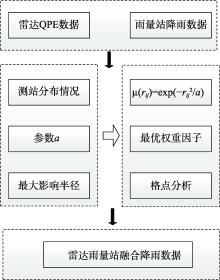
图1
降雨融合模型流程"

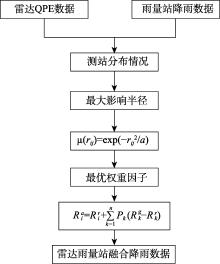
图2
降雨数据融合计算流程"

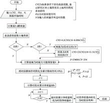
图3
SCS模型产流计算流程 注:图中CN2为标准条件下的径流曲线数,转化为Ⅰ类和Ⅱ类对应的CN,公式均来源于文献[32];S为最大可能滞留量,计算公式来源于文献[33];R为时段净雨量,计算公式来源于文献[34]。"

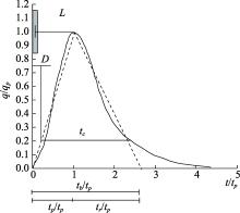
图4
SCS模型的无因次单位曲线 注:图中t、tp、tr、tb和tc分别为洪水过程时间(h)、峰现时间(h)、洪峰消退时间(h)、单位线底宽时间(h)和汇流时间(h);L为流域特征长度(m);D为净雨时段(mm);q和qp分别为流量(m3·s-1)和洪峰流量(m3·s-1)。"

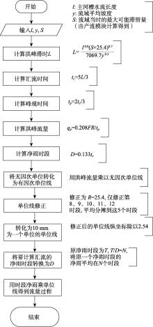
图5
SCS模型汇流计算程序流程[32] 注:图中l为主河槽水流长度(m);y为流域平均坡度(%);S为流域最大可能滞留量(mm);L为洪峰滞时(h);tp和tc分别为汇流时间(h)和峰现时间(h);qp为洪峰流量(m3·s-1);D为净雨时段(h)。"

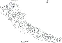
图6
疏勒河上游小流域单元划分示意图"

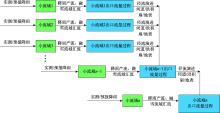
图7
模型预报计算结构"

表1
模型所需基础数据"
| 模型类型 | 模型参数名称 | 初始值 | 单位 |
|---|---|---|---|
| 河道演进 模型 | 马斯京根法河道 分段数 | 1 | 个 |
| 马斯京根法计算 初始流量 | 0.5 | m3·s-1 | |
| 河道汇流马斯京 根法系数 | 0.4 | - | |
| 稳定河道洪水传 播历时 | 3 | h | |
| 径流曲线 模型 | CN值 | 75 | 个 |
| 初损系数 | 0.2 | - | |
| 土壤蓄水能力SW | 13 | mm | |
| 无因次单位线 | 1 | - | |
| 长度 | 62.477 | m | |
| 坡度 | 0.023 | % | |
| 流域当时的最大 可能滞留量 | 0 | m3·s-1 | |
| 融雪径流 模型 | 融雪径流系数 | 1 | - |
| 气温日融雪率 | 2 | mm·(℃·d)-1 | |
| 流域温度直减率 | 1 | ℃·(100m)-1 | |
| 降雨融雪度系数 | 1 | - | |
| 融雪临界温度 | 1 | ℃ | |
| 流量衰减系数 | 1 | - |
表2
昌马水库率定记录"
| 洪号 | 实测 | 洪峰流量检验 | 模拟峰现时间 | |||||||||
|---|---|---|---|---|---|---|---|---|---|---|---|---|
| 起涨时间 | 起涨流量 /( m3·s-1 ) | 洪峰流量 /(m3·s-1) | 峰现时间 | 模拟洪峰 /(m3·s-1) | 许可误差/% | 合格否 | 模拟时间 | 许可 误差 | 合格否 | |||
| 20230711 | 2023-07-12 06:00 | 12.7 | 271.2 | 2023-07-12 11:00 | 291 | 6.8 | √ | 2023-07-12 13:00 | 2 h | √ | ||
图8
洪号20230711昌马水库洪水"

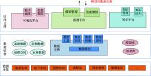
图9
疏勒河数字孪生流域的洪水模型应用总体架构"
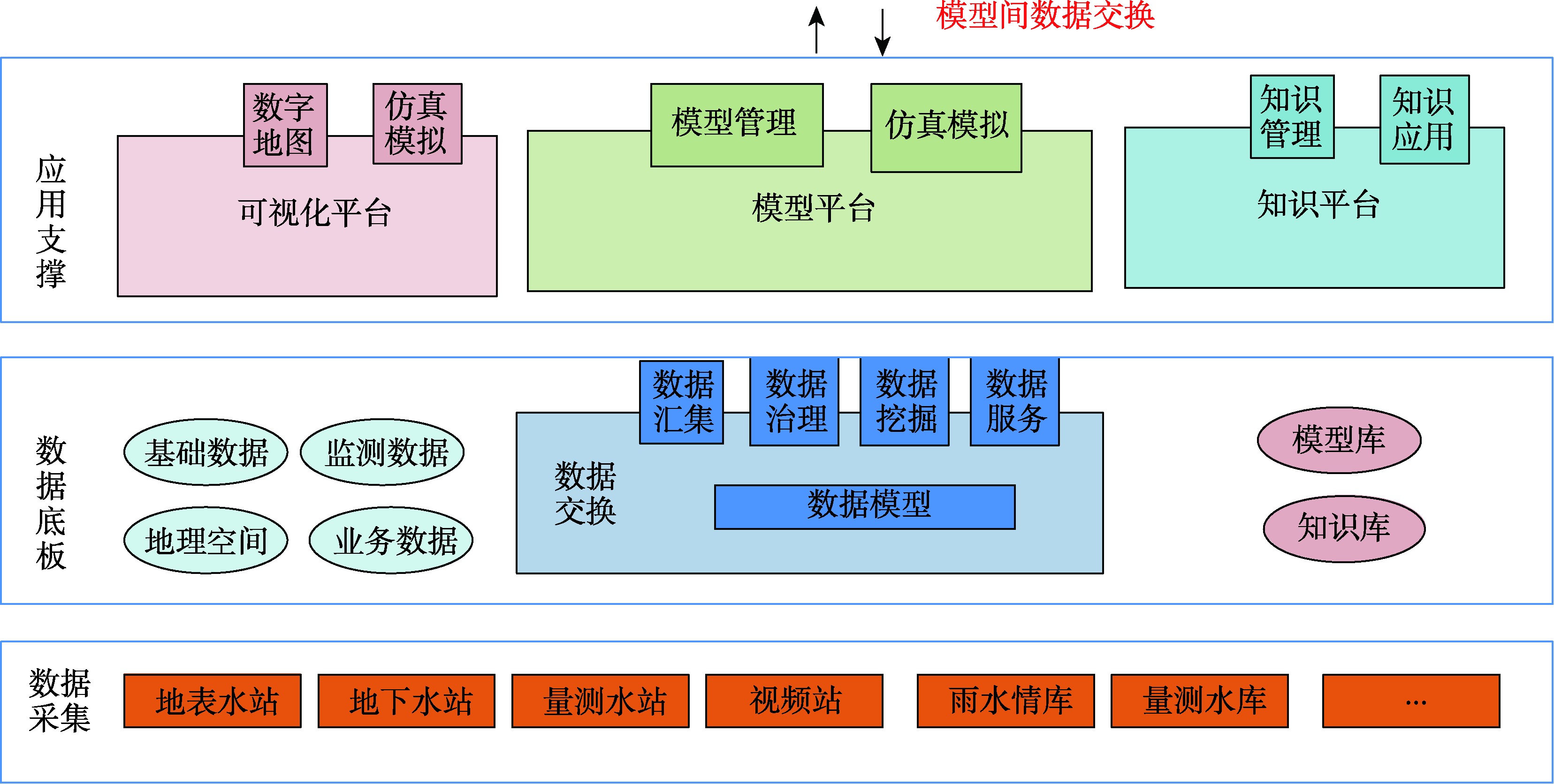
表3
洪水预报接口设计"
| 模型类型 | 输入 | 输出 |
|---|---|---|
| 河道演进模型 | 开始时间 | 开始时间 结束时间 流域出口断面流量 过程 |
| 结束时间 | ||
| 第一断面第一时刻 初始流量 | ||
| 第一断面第二时刻 初始流量 | ||
| 第二断面第一时刻 初始流量 | ||
| 河道汇流马斯京根 法系数 | ||
| 稳定河道洪水传播 历时 | ||
| 径流曲线模型 | 开始时间 | 开始时间 结束时间 流域出口断面流量 过程 |
| 结束时间 | ||
| 流域面平均雨量 | ||
| CN值 | ||
| 初损系数 | ||
| 土壤湿润等级 | ||
| 无因次单位线 | ||
| 流域概化长度 | ||
| 流域坡度 | ||
| 流域当时的最大可 能滞留量 | ||
| 融雪径流模型 | 开始时间 | 开始时间 结束时间 流域出口断面流量 过程 |
| 结束时间 | ||
| 融雪径流系数 | ||
| 气温日融雪率 | ||
| 流域温度直减率 | ||
| 降雨融雪度系数 | ||
| 融雪临界温度 | ||
| 流量衰减系数 | ||
| 高度带 | ||
| 面降雨量 |
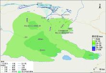
图10
疏勒河流域2024年7月13日降雨预报"

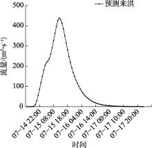
图11
昌马水库2024年7月14日入库洪水预报"


图12
昌马水库实时流量监测数据"
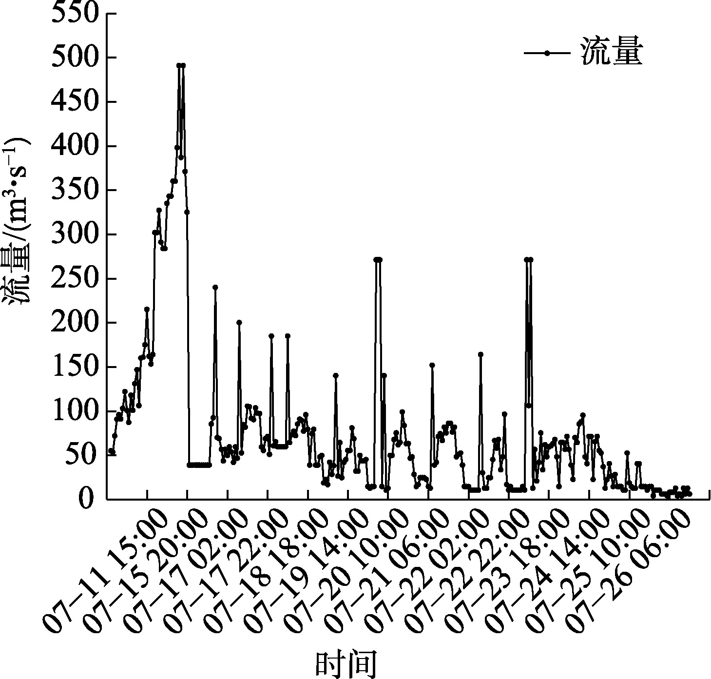
表4
昌马水库2024年7月15日洪峰预测值-实际值误差率"
| 洪峰流量/(m3·s-1) | 洪峰到达时间 | 径流深/m | |
|---|---|---|---|
| 预测 | 438.03 | 7月15日12:00 | 13.01 |
| 实际 | 491 | 7月15日14:00 | 13.33 |
| 误差率/% | 10.80 | 8.33 | 1.61 |
| 规范许可误差率/% | 20 | 30 | 20 |
| [1] |
Zhang Wenxia, Clark Robin, Zhou Tianjun, et al. 2023: Weather and climate extremes hitting the globe with emerging features[J]. Advances in Atmospheric Sciences, 2024, 41(6): 1001-1016.
doi: 10.1007/s00376-024-4080-3 |
| [2] |
杨斐, 张文韬, 张飞民, 等. 1961—2022年祁连山气候特征及其变化[J]. 干旱区研究, 2024, 41(10): 1627-1638.
doi: 10.13866/j.azr.2024.10.02 |
| [ Yang Fei, Zhang Wentao, Zhang Feimin, et al. Climatic characteristics and changes in the Qilian Mountains from 1961 to 2022[J]. Arid Zone Research, 2024, 41(10): 1627-1638. ] | |
| [3] | 慕全鹏, 鲁克新, 杨光, 等. 沮河流域径流变化特征及归因分析[J]. 水力发电学报, 2022, 41(12): 80-89. |
| [ Mu Quanpeng, Lu Kexin, Yang Guang, et al. Characteristics of runoff changes in Ju River basin and attribution analysis[J]. Journal of Hydroelectric Engineering, 2022, 41(12): 80-89. ] | |
| [4] |
张存杰, 张思齐, 宁惠芳. 近60 a中国极端天气气候事件变化趋势及2023年特征分析[J]. 干旱气象, 2024, 42(4):536-552.
doi: 10.11755/j.issn.1006-7639(2024)-04-0536 |
| [ Zhang Cunjie, Zhang Siqi, Ning Huifang. Trends of extreme weather and climate events in China in recent 60 years and their characteristics in 2023[J]. Journal of Arid Meteorology, 2024, 42(4): 536-552. ] | |
| [5] | World Bank. Floods and Droughts: An EPIC Response to These Hazards in the Era of Climate Change[EB/OL]. (2021-06-17) [2025-07-22]. https://www.worldbank.org/en/news/feature/2021/06/17/floods-and-droughts-an-epic-response-to-these-hazards-in-the-era-of-climate-change. |
| [6] |
Soomro Shan-e-hyder, Hu Caihong, Boota Muhammad Waseem, et al. Assessment of the climatic variability of the Kunhar River Basin, Pakistan[J]. Water, 2021, 13(13): 1740.
doi: 10.3390/w13131740 |
| [7] |
Guo Xiaona, Cheng Jie, Yin Chenglong, et al. The extraordinary Zhengzhou flood of 7/20, 2021: How extreme weather and human response compounding to the disaster[J]. Cities, 2023, 134: 104168.
doi: 10.1016/j.cities.2022.104168 |
| [8] |
Hirabayashi Yukiko, Mahendran Roobavannan, Koirala Sujan, et al. Global flood risk under climate change[J]. Nature climate change, 2013, 3: 816-821.
doi: 10.1038/nclimate1911 |
| [34] |
Younos T. Curve number hydrology: State of the practice[J]. Journal of the American Water Resources Association, 2009, 45(4): 1063-1063.
doi: 10.1111/jawr.2009.45.issue-4 |
| [35] | 夏军. 中国水文计算手册(第二版)[M]. 北京: 水利电力出版社, 2006. |
| [ Xia Jun. Hydrological Computation Manual of China[M]. 2nd ed. Beijing: Water Resources & Electric Power Press, 2006. ] | |
| [36] | 杨飞, 刘博伦, 江恩慧, 等. 基于马斯京根法的多沙河流输沙演算[J]. 人民黄河, 2023, 45(11): 39-42. |
| [ Yang Fei, Liu Bolun, Jiang Enhui, et al. Muskingum method based sediment calculations in sediment aden rivers[J]. Yellow River, 2023, 45(11): 39-42. ] | |
| [9] | 刘荣华, 王雪梅, 刘晓婉, 等. 暴雨山洪模拟与预警模型研究进展与展望[J]. 中国防汛抗旱, 2025, 35(6): 1-10. |
| [ Liu Ronghua, Wang Xuemei, Liu Xiaowan, et al. Research progress and prospects of flash flood simulation and warning models[J]. China Flood & Drought Management, 2025, 35(6): 1-10. ] | |
| [10] | 刘永强, 刘志辉. 基于Web的融雪洪水预警模型库系统研究与实现[J]. 干旱区研究, 2008, 25(1): 47-52. |
|
[ Liu Yongqiang, Liu Zhihui. Study and application of the web-based model base system for snow melt flood precaution[J]. Arid Zone Research, 2008, 25(1): 47-52. ]
doi: 10.3724/SP.J.1148.2008.00047 |
|
| [11] |
Wang X M, Zhai X Y, Zhang Y Y, et al. Evaluating flash flood simulation capability with respect to rainfall temporal variability in a small mountainous catchment[J]. Journal of Geographical Sciences, 2023, 33(12): 2530-2548.
doi: 10.1007/s11442-023-2188-5 |
| [12] |
张梅洁, 吕海深, 刘娣, 等. 耦合融雪的新安江模型在干旱区径流模拟研究[J]. 干旱区研究, 2022, 39(2): 379-387.
doi: 10.13866/j.azr.2022.02.05 |
|
[ Zhang Meijie, Lyu Haishen, Liu Di, et al. Runoff simulation in an arid area using the Xinanjiang model coupled with snowmelt[J]. Arid Zone Research, 2022, 39(2): 379-387.]
doi: 10.13866/j.azr.2022.02.05 |
|
| [13] |
Husain Najafi, Pallav Kumar Shrestha, Oldrich Rakovec, et al. High-resolution impact-based early warning system for riverine flooding[J]. Nature Communications, 2024, 15(1): 3726.
doi: 10.1038/s41467-024-48065-y pmid: 38698000 |
| [14] | 徐源浩, 邬强, 李常青, 等. 基于长短时记忆(LSTM)神经网络的黄河中游洪水过程模拟及预报[J]. 北京师范大学学报(自然科学版), 2020, 56(3): 387-393. |
| [ Xu Yuanhao, Wu Qiang, Li Changqing, et al. Simulation of the flood process in the middle reaches of the Yellow River by a long-short term memory (LSTM) neuro network[J]. Journal of Beijing Normal University (Natural Science), 2020, 56(3): 387-393. ] | |
| [15] | 刘成帅, 孙悦, 胡彩虹, 等. 考虑产流模式空间分布的流域-城市复合系统洪水预报模型[J]. 水科学进展, 2023, 34(4): 530-540. |
| [ Liu Chengshuai, Sun Yue, Hu Caihong, et al. Study on flood forecasting model of watershed-urban complex system considering the spatial distribution of runoff generation pattern[J]. Advances in Water Science, 2023, 34(4): 530-540. ] | |
| [16] |
Xu T F, Liang F. Machine learning for hydrologic sciences: An introductory overview[J]. Wiley Interdisciplinary Reviews: Water, 2021, 8(5): e1533.
doi: 10.1002/wat2.v8.5 |
| [17] |
Qi Qinglin, Tao Fei, Hu Tianliang, et al. Enabling technologies and tools for digital twin[J]. Journal of Manufacturing Systems, 2021, 58: 3-21.
doi: 10.1016/j.jmsy.2019.10.001 |
| [18] |
Xia Haishan, Liu Zishuo, Efremochkina Maria, et al. Study on city digital twin technologies for sustainable smart city design: A review and bibliometric analysis of geographic information system and building information modeling integration[J]. Sustainable Cities and Society, 2022, 84: 104009.
doi: 10.1016/j.scs.2022.104009 |
| [19] | 黄艳, 喻杉, 罗斌, 等. 面向流域水工程防灾联合智能调度的数字孪生长江探索[J]. 水利学报, 2022, 53(3): 253-269. |
| [ Huang Yan, Yu Shan, Luo Bin, et al. Development of the digital twin Changjiang River with the pilot system of joint and intelligent regulation of water projects for flood management[J]. Journal of Hydraulic Engineering, 2022, 53(3): 253-269. ] | |
| [20] | 冶运涛, 蒋云钟, 梁犁丽, 等. 数字孪生流域: 未来流域治理管理的新基建新范式[J]. 水科学进展, 2022, 33(5): 683-704. |
| [ Ye Yuntao, Jiang Yunzhong, Liang Lili, et al. Digital twin watershed: New infrastructure and new paradigm of future watershed governance and management[J]. Advances in Water Science, 2022, 33(5): 683-704. ] | |
| [21] |
贾玲, 张百祖, 牛最荣, 等. 疏勒河上游径流变化与预测分析[J]. 干旱区研究, 2022, 39(5): 1588-1597.
doi: 10.13866/j.azr.2022.05.23 |
|
[ Jia Ling, Zhang Baizu, Niu Zuirong, et al. Analysis of runoff variation and prediction in the upper reaches of the Shule River[J]. Arid Zone Research, 2022, 39(5): 1588-1597. ]
doi: 10.13866/j.azr.2022.05.23 |
|
| [22] |
季宗虎, 孙栋元, 牛最荣, 等. 疏勒河流域降水变化特征研究[J]. 干旱区研究, 2023, 40(10): 1583-1594.
doi: 10.13866/j.azr.2023.10.05 |
|
[ Ji Zonghu, Sun Dongyuan, Niu Zuirong, et al. Study on precipitation variation characteristics in Shule River Basin[J]. Arid Zone Research, 2023, 40(10): 1583-1594. ]
doi: 10.13866/j.azr.2023.10.05 |
|
| [23] | 李毅, 黄诗峰, 臧文斌, 等. 基于虚拟地理环境的数字孪生流域防洪应用技术探讨[J]. 遥感学报, 2024, 28(5): 1330-1339. |
|
[ Li Yi, Huang Shifeng, Zang Wenbin, et al. Discussion on flood control application technology of digital twin basin based on virtual geographic environment[J]. National Remote Sensing Bulletin, 2024, 28(5): 1330-1339. ]
doi: 10.11834/jrs.20233022 |
|
| [24] | 中华人民共和国水利部. 数字孪生水利工程建设技术导则[R]. 北京: 中华人民共和国水利部, 2022. |
| [ Ministry of Water Resources of the People’s Republic of China. Technical Guidelines for the Construction of Digital Twin Water Conservancy Projects[R]. Beijing: Ministry of Water Resources of the People’s Republic of China, 2022. ] | |
| [25] | 中华人民共和国水利部. 数字孪生流域建设技术大纲[R]. 北京: 中华人民共和国水利部, 2022. |
| [ Ministry of Water Resources of the People’s Republic of China. Technical Outline for the Construction of Digital Twin River Basins[R]. Beijing: Ministry of Water Resources of the People’s Republic of China, 2022. ] | |
| [26] | 周文慧, 钞小静. 黄河流域数字基础设施、经济发展韧性与生态环境保护的耦合协调发展分析: 基于三元系统耦合协调模型[J]. 干旱区资源与环境, 2023, 37(9): 1-9. |
| [ Zhou Wenhui, Chao Xiaojing. Coupling coordinated development of digital infrastructure, economic resilience and environmental protection in the Yellow River Basin: An approach of ternary system coupling coordination model[J]. Journal of Arid Land Resources and Environment, 2023, 37(9): 1-9. ] | |
| [27] | Li Wenxue, Kou Huaizhong. Thoughts on the construction of digitaltwin Yellow River in the new stage[J]. China Flood & Drought Management, 2022, 32(2): 27-31. |
| [28] | 王井腾, 孙祥鹏, 张文明, 等. 珠江防汛“四预”平台建设及应用[J]. 中国水利, 2022(22): 39-42. |
| [ Wang Jingteng, Sun Xiangpeng, Zhang Wenming, et al. Construction and application of “four pre” platform for the Pearl River flood control[J]. China Water Resources, 2022(22): 39-42. ] | |
| [29] | 刘昌军, 吕娟, 任明磊, 等. 数字孪生淮河流域智慧防洪体系研究与实践[J]. 中国防汛抗旱, 2022, 32(1): 47-53. |
| [ Liu Changjun, Lyu Juan, Ren Minglei, et al. Research and application of digital twin intelligent flood prevention system in Huaihe River Basin[J]. China Flood and Drought Management, 2022, 32(1): 47-53. ] | |
| [30] | 赵杏英, 毛肖钰, 徐红权, 等. 数字流域多尺度空间地理信息模型构建及应用——以钱塘江流域为例[J]. 人民长江, 2021, 52(Suppl. 2): 293-297. |
| [ Zhao Xingying, Mao Xiaoyu, Xu Hongquan, et al. Establishment and application of multi-scale geography information model for digital river basin: Case of Qiantangjiang River basin[J]. Yangtze River, 2021, 52(Suppl. 2): 293-297. ] | |
| [31] | 张建新. 数字孪生技术在疏勒河流域的应用和探讨[J]. 中国水利, 2023(23): 58-62. |
| [ Zhang Jianxin. Application and discussion of digital twin technology in the Shule River Basin[J]. China Water Resources, 2023(23): 58-62. ] | |
| [32] | 张永明, 蒲秉华, 王鹏全, 等. 兰州新区SCS径流模型改进与应用研究[J]. 人民黄河, 2021, 43(3): 24-28. |
| [ Zhang Yongming, Pu Binghua, Wang Pengquan, et al. Improvement and application of SCS runoff model in Lanzhou new district[J]. Yellow River, 2021, 43(3): 24-28. ] | |
| [33] | U.S. Department of Agriculture, Soil Conservation Service. National Engineering Handbook, Section 4: Hydrology[M]. Rev. ed. Washington, D.C.: USDA-SCS, 1972. |
| [1] | 黄志溥, 王军德, 程玉菲, 周昊昊, 张展, 包志为, 杨传国. 疏勒河中下游生态脆弱区土地利用变化与未来生境质量评估[J]. 干旱区研究, 2025, 42(11): 2104-2116. |
| [2] | 王士维, 孙栋元, 周敏, 王亦可, 王祥镔, 季宗虎, 张文睿, 武兰珍. 1951—2020年疏勒河流域气温时空变化特征[J]. 干旱区研究, 2023, 40(7): 1065-1074. |
| [3] | 季宗虎, 孙栋元, 牛最荣, 王兴繁, 武兰珍, 马亚丽, 陈彩苹, 崔艳强. 疏勒河流域降水变化特征研究[J]. 干旱区研究, 2023, 40(10): 1583-1594. |
| [4] | 王学良,陈仁升,刘俊峰,韩春坛. 1956—2021年疏勒河流域主要河流出山径流变化及成因分析[J]. 干旱区研究, 2022, 39(6): 1782-1792. |
| [5] | 贾玲,张百祖,牛最荣,孙栋元,孙凯悦,王鲁军. 疏勒河上游径流变化与预测分析[J]. 干旱区研究, 2022, 39(5): 1588-1597. |
| [6] | 王毓芳,赵成章,曾红霞,康满萍,赵婷婷,唐玉瑞. 疏勒河中游湿地景观时空演变及其影响因素[J]. 干旱区研究, 2022, 39(1): 282-291. |
| [7] | 郭晓娟, 周妍妍, 郭建军, 陈冠光, 岳东霞. 疏勒河流域土壤含水率反演[J]. 干旱区研究, 2018, 35(6): 1317-1326. |
| [8] | 陈心池,张利平,闪丽洁,杨卫,贾军. 新疆山区中小河流洪水预报模型及其应用[J]. 干旱区研究, 2017, 34(6): 1426-1435. |
|
||