干旱区研究 ›› 2021, Vol. 38 ›› Issue (6): 1579-1589.doi: 10.13866/j.azr.2021.06.10
卢宝宝1( ),孙慧兰1(),姜泉泉2,曹丽君1,兰小丽1,张乐乐1,刘天弋1
收稿日期:2020-12-12
修回日期:2021-02-16
出版日期:2021-11-15
发布日期:2021-11-29
通讯作者:
孙慧兰
作者简介:卢宝宝(1994-),男,硕士,主要从事自然资源开发与规划方面的研究. E-mail: 基金资助:
LU Baobao1(),SUN Huilan1(),JIANG Quanquan2,CAO Lijun1,LAN Xiaoli1,ZHANG Lele1,LIU Tianyi1
Received:2020-12-12
Revised:2021-02-16
Online:2021-11-15
Published:2021-11-29
Contact:
Huilan SUN
摘要:
采用新疆58个气象站1965—2017年逐日气象资料,通过Penman-Monteith (P-M)模型计算潜在蒸散,并结合降水量求得水分盈亏量;应用Mann-Kendall (M-K)突变检验、小波分析和Pearson相关分析方法,分析了新疆水分盈亏量时空变化特征及其影响因素。结果表明:(1) 近53 a来新疆地区水分盈亏量年际变化总体呈增加趋势,天山以南水分盈亏量增加速率最大,其次是天山以北,天山区最小,全疆平均增加速率为72.28 mm·(10a)-1;季节上水分盈亏量的变化:夏季>春季>秋季>冬季,夏季线性变化速率最大,冬季最小。(2) 空间上各季节水分亏损最大值主要出现在吐鲁番盆地及周边、哈密地区以及巴音郭楞蒙古自治州北部地区,最小值主要位于伊犁河谷及阿勒泰地区。变化趋势上大部分地区年水分盈亏量都处于增加趋势,减小趋势主要位于天山以北及塔里木盆地部分地区。(3) 新疆平均水分盈亏量时序数据1985年发生了一次突变,除天山以北地区外,其余地区2000年以来水分盈亏量下降趋势明显,并且以28 a的时间周期为第一主周期发生变化。
卢宝宝,孙慧兰,姜泉泉,曹丽君,兰小丽,张乐乐,刘天弋. 近53 a新疆水分盈亏量时空变化特征[J]. 干旱区研究, 2021, 38(6): 1579-1589.
LU Baobao,SUN Huilan,JIANG Quanquan,CAO Lijun,LAN Xiaoli,ZHANG Lele,LIU Tianyi. Spatiotemporal variation characteristics of the water budget in Xinjiang during the latest 53 years[J]. Arid Zone Research, 2021, 38(6): 1579-1589.
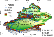
图1
研究区示意图 注:底图采用自然资源部标准地图制作,审图号:GS(2019)3333号,底图无修改。下同。"

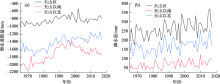
图2
降水量和潜在蒸散量年际变化"

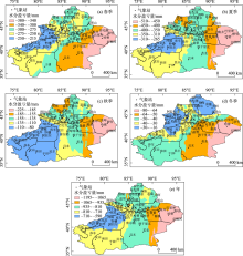
图3
1965—2017年新疆水分盈亏量空间分布"


图4
1965—2017年新疆多年平均水分盈亏量年际变化"
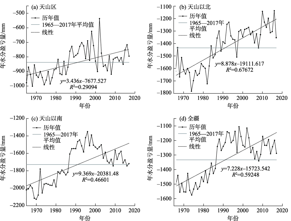
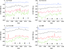
图5
1965—2017年新疆四季水分盈亏量的变化"

表1
1965—2017年新疆四季水分盈亏量变化趋势"
| 水分盈亏量 | 天山以北 | 天山区 | 天山以南 | 全疆 |
|---|---|---|---|---|
| 冬季 | 3.88* | 2.61* | 2.08 | 2.64* |
| 春季 | 12.65* | 10.19 | 11.93* | 11.59* |
| 夏季 | 24.58* | 12.92* | 18.95* | 18.82* |
| 秋季 | 13.97* | 5.99* | 10.01* | 9.99* |
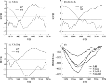
图6
平均水分盈亏量的M-K突变检验及累积距平"

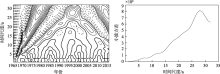
图7
新疆年平均水分盈亏量的Morlet小波系数等值线及小波方差变化曲线"
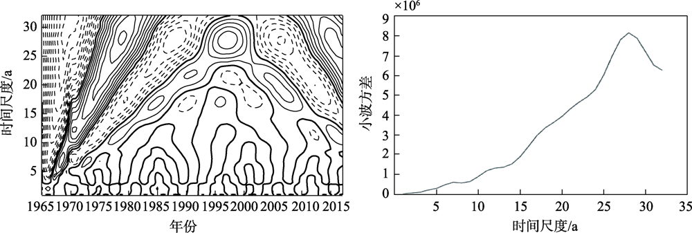
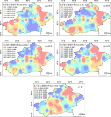
图8
1965—2017年新疆年和四季水分盈亏量倾向率分布"

表2
新疆水分盈亏量与气候因子相关系数"
| 平均气温 | 降水 | 相对湿度 | 平均风速 | 日照时数 | 水气压 | |
|---|---|---|---|---|---|---|
| 冬季 | 0.019 | 0.591** | 0.196 | -0.632** | -0.409** | -0.734** |
| 春季 | 0.031 | 0.661** | 0.377** | -0.754** | -0.412** | -0.846** |
| 夏季 | 0.294* | 0.724** | 0.573** | -0.927** | -0.54** | -0.67* |
| 秋季 | 0.336* | 0.485** | 0.469** | -0.921** | -0.532** | -0.84** |
| 年 | 0.505** | 0.693** | 0.461** | -0.913** | -0.711** | -0.829** |
| 天山区 | 0.288* | 0.753** | 0.477** | -0.639** | -0.783** | -0.685** |
| 天山以北 | 0.41** | 0.738** | 0.401** | -0.876** | -0.686** | -0.285* |
| 天山以南 | 0.41** | 0.551** | 0.522** | -0.953** | -0.387** | -0.263 |
| [1] | 李红瑛, 薛羽, 曹二佳, 等. 近50年来乌兰察布市水分盈亏量时空变化特征[J]. 干旱区资源与环境, 2019, 33(12):145-151. |
| [ Li Hongying, Xue Yu, Cao Erjia, et al. Spatiotemporal variation characteristics of water deficit in Ulanqab during thelatest 50 years[J]. Journal of Arid Land Resources and Environment, 2019, 33(12):145-151. ] | |
| [2] | 刘惠英, 任洪玉, 张平仓, 等. 香溪河流域近60年来降雨量变化趋势及突变分析[J]. 水土保持研究, 2015, 22(4):282-286. |
| [ Liu Huiying, Ren Hongyu, Zhang Pingcang, et al. Analysis of characteristics of variation and abrup change of precipitation in Xiangxi River Watershed over the past 60 years[J]. Research of Soil and Water Conservation, 2015, 22(4):282-286. ] | |
| [3] | 刘友存, 侯兰功, 焦克勤, 等. 全球气候指数与天山地区气温变化遥相关分析[J]. 山地学报, 2016, 34(6):679-689. |
| [ Liu Youcun, Hou Langong, Jiao Keqin, et al. On the teleconnection patterns to air temperature in the Tianshan Mountain, China[J]. Mountain Research, 2016, 34(6):679-689. ] | |
| [4] | 陈颖, 贾孜拉·拜山. 新疆冬季气温年际异常的主模态及其成因分析[J]. 干旱区地理, 2019, 42(2):223-231. |
| [ Chen Ying, Jiazila Baishan. Annual variation of winter temperature and its causes in Xinjiang[J]. Arid Land Geography, 2019, 42(2):223-231. ] | |
| [5] | 刘慧芝. 西北干旱区极端气候事件变化及其对北大西洋涛动指数的响应[D]. 乌鲁木齐: 新疆大学, 2016. |
| [ Liu Huizhi. Changes in the Extreme Weather Events and the Responses to the North Atlantic Oscillation Index in the Arid Northwest China[D]. Urumqi: Xinjiang University, 2016. ] | |
| [6] | 黄建平, 季明霞, 刘玉芝, 等. 干旱半干旱区气候变化研究综述[J]. 气候变化研究进展, 2013, 9(1):9-14. |
| [ Huang Jianping, Ji Mingxia, Liu Yuzhi, et al. An overview of arid and semi-arid climate change[J]. Climate Change Research, 2013, 9(1):9-14. ] | |
| [7] | Li B F, Chen Y N, Shi X, et al. Tempeature and precipitation changes in different environments in the region of Northwest China[J]. Theoretical and Applied Climatology, 2013, 112(3-4):598-595. |
| [8] | 陈亚宁, 杨青, 罗毅, 等. 西北干旱区水资源问题研究思考[J]. 干旱区地理, 2012, 35(1):1-9. |
| [ Chen Yaning, Yang Qing, Luo Yi, et al. Ponder on the issues of water resources in the arid region of Northwest China[J]. Arid Land Geography, 2012, 35(1):1-9. ] | |
| [9] | 徐荣潞, 李宝富, 廉丽姝. 1960—2015年西北干旱区相对湿度时空变化与气候要素的定量关系[J]. 水土保持研究, 2020, 27(6):233-239. |
| [ Xu Ronglu, Li Baofu, Lian Lishu. Quantitative relationship between the spatiotemporal change of relative humidity and climatic factors in the arid region of Northwest China from 1960 to 2015[J]. Research of Soil and Water Conservation, 2020, 27(6):233-239. ] | |
| [10] | 赵俊芳, 郭建平, 徐精文, 等. 基于湿润指数的中国干湿状况变化趋势[J]. 农业工程学报, 2010, 26(8):18-24. |
| [ Zhao Junfang, Guo Jianping, Xu Jingwen, et al. Trends of Chinese dry-wet condition based on wetness index[J]. Transactions of the Chinese Society of Agricultural Engineering, 2010, 26(8):18-24. ] | |
| [11] | 曾丽红, 宋开山, 张柏. 1951—2008年东北地区水分盈亏量时空格局[J]. 自然资源学报, 2011, 26(5):858-870. |
| [ Zeng Lihong, Song Kaishan, Zhang Bai. Spatia land temporal structure of water deficit over Northeast China during the period of 1951-2008[J]. Journal of Natural Resources, 2011, 26(5):858-870. ] | |
| [12] | 颜雅琼, 申双和. 近50多年来淮河流域气候水分盈亏时空变化[J]. 气象科学, 2019, 39(4):457-465. |
| [ Yan Yaqiong, Shen Shuanghe. Spatial and temporal changes of climatic and water deficitin the Huaihe River Basin over past 50 years[J]. Journal of the Meteorological Sciences, 2019, 39(4):457-465. ] | |
| [13] | 史建国, 严昌荣, 何文清, 等. 黄河流域水分亏缺时空格局变化研究[J]. 自然资源学报, 2008, 23(1):113-119. |
| [ Shi Jianguo, Yan Changrong, He Wenqing, et al. Study on spatial and temporal variation of water surplus and deficiency in Yellow River basin[J]. Journal of Natural Resources, 2008, 23(1):113-119. ] | |
| [14] | 徐冬平, 卜金洋, 杨军辉. 黄河流域水分盈亏量时空变化及其影响因素[J]. 干旱区研究, 2016, 33(4):739-746. |
| [ Xu Dongping, Bu Jinyang, Yang Junhui. Spatiotemporal change of water budget and its affecting factors in the Yellow River basin[J]. Arid Zone Research, 2016, 33(4):739-746. ] | |
| [15] |
高歌, 许崇育. 1961—2010年中国十大流域水分盈亏量时空变化特征[J]. 地理学报, 2015, 70(3):380-391.
doi: 10.11821/dlxb201503003 |
|
[ Gao Ge, Xu Chongyu. Characteristics of water surplus and deficit change in 10 major river basins in China during 1961 to 2010[J]. Acta Geographica Sinica, 2015, 70(3):380-391. ]
doi: 10.11821/dlxb201503003 |
|
| [16] | 姚玉龙, 刘普幸, 卓玛兰草. 51a来甘肃省水分盈亏量的时空变化特征[J]. 干旱区研究, 2014, 31(2):202-208. |
| [ Yao Yulong, Liu Puxing, Zhuoma Lancao. Spatiotemporal change of water budget in Gansu province in recent 51 years[J]. Arid Zone Research, 2014, 31(2):202-208. ] | |
| [17] | 姚晓军, 张晓, 孙美平, 等. 1960—2010年中国西北地区水分盈亏量时空特征[J]. 地理研究, 2013, 32(4):607-616. |
| [ Yao Xiaojun, Zhang Xiao, Sun Meiping, et al. Spatial-temporal characteristics of water deficit in Northwest China from 1960 to 2010[J]. Geographical Research, 2013, 32(4):607-616. ] | |
| [18] | 李佳秀, 陈亚宁, 刘志辉. 新疆不同气候区的气温和降水变化及其对地表水资源的影响[J]. 中国科学院大学学报, 2018, 35(3):371-380. |
| [ Li Jiaxiu, Chen Yaning, Liu Zhihui. Variations in temperature and precipitation and their influences on surface water resource in different climate zones of Xinjiang[J]. Journal of University of Chinese Academy of Sciences, 2018, 35(3):371-380. ] | |
| [19] | 刘伟, 姜逢清, 李小兰. 新疆气候变化的适应能力时空演化特征[J]. 干旱区研究, 2017, 34(3):531-540. |
| [ Liu Wei, Jiang Fengqing, Li Xiaolan. Spatiotemporal evolution of adaptive capacity to climate change in Xinjiang[J]. Arid Zone Research, 2017, 34(3):531-540. ] | |
| [20] | 张扬, 楚新正, 杨少敏, 等. 近56 a新疆北部地区气候变化特征[J]. 干旱区研究, 2019, 36(1):212-219. |
| [ Zhang Yang, Chu Xinzheng, Yang Shaomin. Climate change in North Xinjiang in recent 56 years[J]. Arid Zone Research, 2019, 36(1):212-219. ] | |
| [21] | 张音 古丽贤·吐尔逊拜, 苏里坦,, 等. 近60 a来新疆不同海拔气候变化的时空特征[J]. 干旱区地理, 2019, 42(4):822-829. |
| [ Zhang Yin, Tuerxunbai Gulixian, Su Litan, et al. Spatial and temporal characteristics of climate change at different altitudes in Xinjiang in the past 60 years[J]. Arid Land Geography, 2019, 42(4):822-829. ] | |
| [22] | 普宗朝, 张山清, 王胜兰, 等. 近48 a新疆干湿气候时空变化特征[J]. 中国沙漠, 2011, 31(6):1563-1572. |
| [ Pu Zongchao, Zhang Shanqing, Wang Shenglan, et al. The spitial-temporal variation characteristic of dry-wet climate in recent 48 years in Xinjiang Province, China[J]. Journal of Desert Research, 2011, 31(6):1563-1572. ] | |
| [23] | 宋佳, 徐长春, 杨媛媛, 等. 基于MODIS16的新疆干湿气候时空变化及影响因素[J]. 水土保持研究, 2019, 26(5):210-221. |
| [ Song Jia, Xu Changchun, Yang Yuanyuan, et al. Temporal and spitial variation characteristic of evapotransiration and dry-wet climate in Xinjiang based on MODIS16[J]. Research of Soil and Water Conservation, 2019, 26(5):210-221. ] | |
| [24] |
Jiapaer G L, Liang S L, Yi Q X, et al. Vegetation dynamics and responses to recent climate change in Xinjiang using leaf area index as an indicator[J]. Ecological Indicators, 2015, 58(5):64-76.
doi: 10.1016/j.ecolind.2015.05.036 |
| [25] | 邓兴耀, 刘洋, 刘志辉, 等. 中国西北干旱区蒸散发时空动态特征[J]. 生态学报, 2017, 37(9):2994-3008. |
| [ Deng Xingyao, Liu Yang, Liu Zhihui, et al. Temporal-spatial dynamic change characteristics of evapotranspiration in arid region of Northwest China[J]. Acta Ecologica Sinica, 2017, 37(9):2994-3008. ] | |
| [26] | 姚俊强, 杨青, 刘志辉, 等. 中国西北干旱区降水时空分布特征[J]. 生态学报, 2015, 35(17):5846-5855. |
| [ Yao Junqiang, Yang Qing, Liu Zhihui, et al. Spatiotemporal change of precipitation in arid region of the Northwest China[J]. Acta Ecologica Sinica, 2015, 35(17):5846-5855. ] | |
| [27] | 杨莲梅, 刘晶. 新疆水汽研究若干进展[J]. 自然灾害学报, 2018, 27(2):1-13. |
| [ Yang Lianmei, Liu Jing. Some advances of water vapor research in Xinjiang[J]. Journal of Natural Disasters, 2018, 27(2):1-13. ] | |
| [28] | 刘燕, 刘友存, 陈明, 等. 基于Penman-Monteith的江南丘陵地区地表参考蒸散量和水分盈亏量特征分析[J]. 安徽农业大学学报, 2019, 46(4):680-688. |
| [ Liu Yan, Liu Youcun, Chen Ming, et al. Analysis on the variation characteristics of surface water in the Jiangnan Hills based on the Penman-Monteith method[J]. Journal of Anhui Agricultural University, 2019, 46(4):680-688. ] | |
| [29] | 陈镜明, 柳竞先, 罗翔中. 基于碳水通量耦合原理改进Penman-Monteith蒸散发模型[J]. 大气科学学报, 2020, 43(1):59-75. |
| [ Chen Jingming, Liu Jingxian, Luo Xiangzhong. Improving the Penman-Monteith evapotranspiration model based on the coupling principle of carbon and water fluxes[J]. Transactions of Atmospheric Sciences, 2020, 43(1):59-75. ] | |
| [30] |
Garcia M, Raes D, Allen R, et al. Dynamics of reference evapotranspiration in the Bolivian highlands (Altiplano)[J]. Agricultural and Forest Meteorology, 2004, 125(1-2):67-82.
doi: 10.1016/j.agrformet.2004.03.005 |
| [31] |
Torrence C, Compo G P. A practical guide to wavelet analysis[J]. Bulletin of the American Meteorological Society, 1998, 79(1):61-78.
doi: 10.1175/1520-0477(1998)079<0061:APGTWA>2.0.CO;2 |
| [32] |
Yue S, Pilon P, Cavadias G. Power of the Mann-Kendall and Spearman’s rho tests for detecting monotonic trends in hydrological series[J]. Journal of Hydrology, 2002, 259(1):254-271.
doi: 10.1016/S0022-1694(01)00594-7 |
| [33] | 张宏芳, 巨晓璇, 卢珊, 等. 精细化网格的降水预报解析方法对比[J]. 气象科技进展, 2019, 9(3):7-14. |
| [ Zhang Hongfang, Ju Xiaoxuan, Lu Shan, et al. Comparison of parsing methods for fine grid precipitation forecasting[J]. Advances in Meteorological Science and Technology, 2019, 9(3):7-14. ] | |
| [34] | 郭小娇, 石建省. 水分蒸散发研究国内外进展与趋势[J]. 地质论评, 2019, 65(6):1473-1486. |
| [ Guo Xiaojiao, Shi Jiansheng. Global review of the research progress and trend of evapotranspiration[J]. Geological Review, 2019, 65(6):1473-1486. ] | |
| [35] | 刘宪锋, 潘耀忠, 张锦水, 等. 1960—2011年西北五省潜在蒸散的时空变化[J]. 应用生态学报, 2013, 24(9):2564-2570. |
| [ Liu Xianfeng, Pan Yaozhong, Zhang Jinshui, et al. Spatiotemporal variation patterns of potential evapotranspiration in five provinces of Northwes China in 1966-2011[J]. Chinese Journal of Applied Ecology, 2013, 24(9):2564-2570. ] | |
| [36] |
Li Y, Chen Y, Li Z, Fang G. Recent recovery of surface wind speed in Northwest China[J]. International Journal of Climatology, 2018, 38(12):4445-4458.
doi: 10.1002/joc.2018.38.issue-12 |
| [37] |
姚俊强, 毛炜峄, 陈静, 等. 新疆气候“湿干转折”的信号和影响探讨[J]. 地理学报, 2021, 76(1):57-72.
doi: 10.11821/dlxb202101005 |
|
[ Yao Junqiang, Mao Weiyi, Chen Jing, et al. Signal and impact of wet-to-dry shift over Xinjiang, China[J]. Acta Geographica Sinica, 2021, 76(1):57-72. ]
doi: 10.11821/dlxb202101005 |
| [1] | 李小锋, 惠婷婷, 李耀明, 毛洁菲, 王光宇, 范连连. 不同放牧管理方式对新疆山地草原植物群落特征的影响[J]. 干旱区研究, 2024, 41(1): 124-134. |
| [2] | 赵雨琪, 魏天兴. 1990—2020年黄土高原典型县域植被覆盖变化及影响因素[J]. 干旱区研究, 2024, 41(1): 147-156. |
| [3] | 胡广录,陶虎,焦娇,白元儒,陈海志,麻进. 黑河中游正义峡径流变化趋势及归因分析[J]. 干旱区研究, 2023, 40(9): 1414-1424. |
| [4] | 周小东, 常顺利, 王冠正, 张毓涛, 喻树龙, 张同文. 天山北坡中段雪岭云杉径向生长对气候变化的响应[J]. 干旱区研究, 2023, 40(8): 1215-1228. |
| [5] | 汪翔, 吕海深, 朱永华, 郭晨煜. 两种河道洪水演进方法在新疆山区的应用比较[J]. 干旱区研究, 2023, 40(8): 1240-1247. |
| [6] | 王超, 马占仓, 潘成南, 吴星月, 宋文丹, 阎平. 新疆苋属新记录植物[J]. 干旱区研究, 2023, 40(8): 1280-1288. |
| [7] | 古丽斯旦·艾尼瓦尔, 吐尔洪·努尔东, 地力胡马尔·阿不都克热木, 买买提明·苏来曼. 新疆薄罗藓科植物新记录[J]. 干旱区研究, 2023, 40(8): 1289-1293. |
| [8] | 李虹, 李忠勤, 陈普晨, 彭加加. 近20 a新疆阿尔泰山积雪时空变化及其影响因素[J]. 干旱区研究, 2023, 40(7): 1040-1051. |
| [9] | 孟乘枫, 仲涛, 郑江华, 王南, 刘泽轩, 任祥源. 昆仑山冰湖分布时空特征及驱动力[J]. 干旱区研究, 2023, 40(7): 1094-1106. |
| [10] | 许君利, 韩海东, 王建. 新疆大气PM2.5来源与潜在贡献源分析[J]. 干旱区研究, 2023, 40(6): 874-884. |
| [11] | 赵艳芬, 潘伯荣. 气候变化情景下革苞菊属在中国的潜在地理分布[J]. 干旱区研究, 2023, 40(6): 949-957. |
| [12] | 薛一波, 黄双燕, 张小啸, 雷加强, 李生宇. 新疆2018年冬季雨雪风沙强降尘事件[J]. 干旱区研究, 2023, 40(5): 681-690. |
| [13] | 赵克明, 孙鸣婧, 李霞, 施俊杰, 安大维, 许婷婷. 两种典型大气扩散指数在新疆的分布特征及其适用性对比[J]. 干旱区研究, 2023, 40(5): 691-702. |
| [14] | 姚春艳, 刘洪鹄, 刘竞. 长江源区1980—2020年水沙变化规律[J]. 干旱区研究, 2023, 40(5): 726-736. |
| [15] | 胡亚男, 裴浩, 姜艳丰, 苗百岭, 贾成朕. 1991—2021年内蒙古降水酸碱度时空变化特征分析[J]. 干旱区研究, 2023, 40(4): 552-562. |
|
||