干旱区研究 ›› 2021, Vol. 38 ›› Issue (4): 1104-1110.doi: 10.13866/j.azr.2021.04.22
李梓钰( ),陈启慧,黄峰(),郭振天
收稿日期:2021-01-26
修回日期:2021-03-15
出版日期:2021-07-15
发布日期:2021-08-03
通讯作者:
黄峰
作者简介:李梓钰(1997-),女,硕士研究生,研究方向为生态水文. E-mail: 基金资助:
LI Ziyu(),CHENG Qihui,HUANG Feng(),GUO Zhentian
Received:2021-01-26
Revised:2021-03-15
Online:2021-07-15
Published:2021-08-03
Contact:
Feng HUANG
摘要:
基于Landsat TM/ETM+/OLI影像数据和无人机影像,通过建立归一化植被指数(normalized difference vegetation index,NDVI)和植被覆盖度关系,计算像元二分模型的参数值,反演1996—2020年吐鲁番骆驼刺保护区的植被覆盖度,再利用一元线性回归分析,研究了吐鲁番骆驼刺保护区历年植被覆盖度演变时空特征。结果表明:25 a来,骆驼刺保护区的植被覆盖度总体呈增加趋势,显著改善区面积占比20.14%,植被覆盖度由3.09%增加至18.30%,主要分布在由西向中部沿白杨河尾闾处和西部、东北部居住用地附近。研究结果可为像元二分模型参数值的确定提供科学参考,为吐鲁番盆地生态环境治理和保护提供科学依据。
李梓钰,陈启慧,黄峰,郭振天. 吐鲁番盆地骆驼刺保护区植被覆盖度时空演变[J]. 干旱区研究, 2021, 38(4): 1104-1110.
LI Ziyu,CHENG Qihui,HUANG Feng,GUO Zhentian. Spatiotemporal evolution of vegetation coverage in Alhagi sparsifolia Reserve in Turpan Basin, Xinjiang[J]. Arid Zone Research, 2021, 38(4): 1104-1110.

图1
骆驼刺保护区位置及样点分布图"
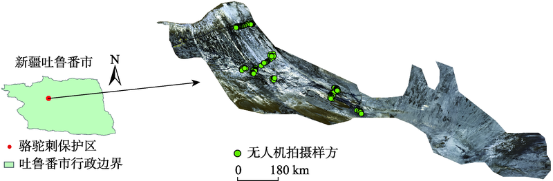
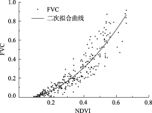
图2
FVC与NDVI关系曲线"

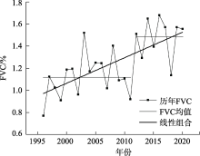
图3
1996—2020年骆驼刺保护区植被覆盖度变化"

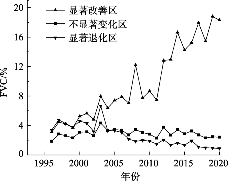
表1
骆驼刺保护区植被覆盖度变化面积及比例"
| 区域 | 植被覆盖度/% | 面积/km2 | 面积比例/% |
|---|---|---|---|
| 显著改善区 | 9.84 | 200.46 | 20.14 |
| 不显著变化区 | 2.92 | 486.31 | 48.87 |
| 显著退化区 | 2.65 | 308.37 | 30.99 |

图4
1996—2020年骆驼刺保护区植被覆盖度变化趋势"
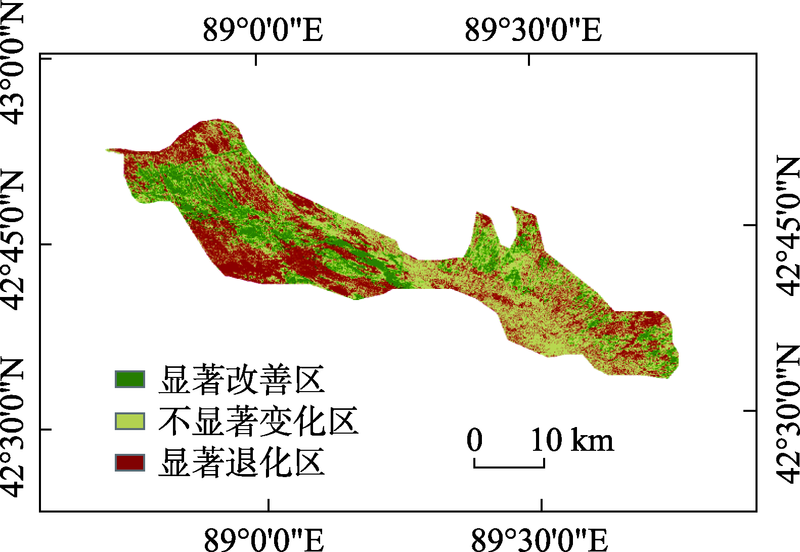

图5
1996—2020年骆驼刺保护区不同区域植被覆盖度变化"
| [1] | 罗瀚林, 曾凡江, 郭自春, 等. 春季与秋季刈割对疏叶骆驼刺叶片功能性状的影响[J]. 草业科学, 2016, 33(4):691-699. |
| [ Luo Hanlin, Zeng Fanjiang, Guo Zichun, et al. Influence of spring and fall clipping on the leaf functional traits of Alhagi Sparsifolia[J]. Pratacultural Science, 2016, 33(4):691-699. ] | |
| [2] | 邢著荣, 冯幼贵, 杨贵军, 等. 基于遥感的植被覆盖度估算方法述评[J]. 遥感技术与应用, 2009, 24(6):849-854. |
| [ Xing Zhurong, Feng Yougui, Yang Guijun, et al. Method of estimating vegatation coverage based on remote sensing[J]. Remote Sensing Technology and Application, 2009, 24(6):849-854. ] | |
| [3] | 程红芳, 章文波, 陈锋. 植被覆盖度遥感估算方法研究进展[J]. 国土资源遥感, 2008, 20(1):13-18. |
| [ Cheng Hongfang, Zhang Wenbo, Chen Feng. Advances in researches on application of remote sensing method to estimating vegetation coverage[J]. Remote Sensing for Land & Resources, 2008, 20(1):13-18. ] | |
| [4] | 郭玉川, 何英, 李霞. 基于MODIS的干旱区植被覆盖度反演及植被指数优选[J]. 国土资源遥感, 2011, 23(2):115-118. |
| [ Guo Yuchuan, He Ying, Li Xia. Remote sensing inversion of vegetation coverage and optimization of vegetation index based on modis data in arid area[J]. Remote Sensing for Land & Resources, 2011, 23(2):115-118. ] | |
| [5] | 古丽·加帕尔, 陈曦, 包安明. 干旱区荒漠稀疏植被覆盖度提取及尺度扩展效应[J]. 应用生态学报, 2009, 20(12):2925-2934. |
| [ Guli Jiapaer, Chen Xi, Bao Anming. Coverage extraction and upscaling of sparse desert vegetation in arid area[J]. Chinese Journal of Applied Ecology, 2009, 20(12):2925-2934. ] | |
| [6] | 陈晋, 陈云浩, 何春阳, 等. 基于土地覆盖分类的植被覆盖率估算亚像元模型与应用[J]. 遥感学报, 2001, 5(6):416-422. |
| [ Chen Jin, Chen Yunhao, He Chunyang, et al. Sub pixel model for vegetation fraction estimation based on land cover classification[J]. Journal of Remote Sensing, 2001, 5(6):416-422. ] | |
| [7] | 白彦. 呼伦贝尔沙地植被覆盖度变化遥感监测研究[D]. 呼和浩特: 内蒙古农业大学, 2013. |
| [ Bai Yan. Study on Vegetation Coverage Change of Hulunbeier Sand Land By Remote Sensing[D]. Hohhot: Inner Mongolia Agricultural University, 2013. ] | |
| [8] | 沈谦, 朱长明, 张新. GF-2支持下的干旱区稀疏植被区植被覆盖度估算[J]. 测绘通报, 2019(7):33-38. |
| [ Shen Qian, Zhu Changming, Zhang Xin. Fractional vegetation cover estimation in arid and rare vegetation area aided by GF-2 remote sensing data[J]. Bulletin of Surveying and Mapping, 2019(7):33-38. ] | |
| [9] |
何宝忠, 丁建丽, 张喆, 等. 新疆植被覆盖度趋势演变实验性分析[J]. 地理学报, 2016, 71(11):1948-1966.
doi: 10.11821/dlxb201611007 |
|
[ He Baozhong, Ding Jianli, Zhang Zhe, et al. Experimental analysis of spatial and temporal dynamics of fractional vegetation cover in Xinjiang[J]. Acta Geographica sinica, 2016, 71(11):1948-1966. ]
doi: 10.11821/dlxb201611007 |
|
| [10] | 覃志豪, 李文娟, 徐斌, 等. 陆地卫星TM6波段范围内地表比辐射率的估计[J]. 国土资源遥感, 2004, 16(3):28-32. |
| [ Qin Zhihao, Li Wenjuan, Xu Bin, et al. The estimation of land surface emissivity for landsat TM6[J]. Remote Sensing for Land & Resources, 2004, 16(3):28-32. ] | |
| [11] | 卞雪. 基于无人机低空遥感影像可见光波段的植被覆盖率研究[D]. 南京: 南京农业大学, 2017. |
| [ Bian Xue. Vegetation Coverage Calculation Using Remote Sensing Image of Unmanned Aerial Vehicle Based on Visible Spectrum[D]. Nanjing: Nanjing University, 2017. ] | |
| [12] | 高永平, 康茂东, 何明珠, 等. 基于无人机可见光波段对荒漠植被覆盖度提取的研究——以沙坡头地区为例[J]. 兰州大学学报(自然科学版), 2018, 54(6):770-775. |
| [ Gao Yongping, Kang Maodong, He Mingzhu, et al. Extraction of desert vegetation coverage based on visible light band information of unmanned aerial vehicle: A case study of Shapotou region[J]. Journal of Lanzhou University(Natural Sciences Edition), 2018, 54(6):770-775. ] | |
| [13] |
Elazab A, Raziel A. Ordóez, Savin R, et al. Detecting interactive effects of N fertilization and heat stress on maize productivity by remote sensing techniques[J]. European Journal of Agronomy, 2016, 73:11-24.
doi: 10.1016/j.eja.2015.11.010 |
| [14] | 万炜, 肖生春, 陈小红, 等. 无人机遥感在野外植被盖度调查中的应用——以阿拉善荒漠区灌木为例[J]. 干旱区资源与环境, 2018, 32(9):150-156. |
| [ Wan Wei, Xiao Shengchun, Chen Xiaohong, et al. Application of unmanned aerial vehicles to field vegetation coverage survey: A study of shrubs on Alxa desert[J]. Journal of Arid Land Resources and Environment, 2018, 32(9):150-156. ] | |
| [15] | 宋清洁, 崔霞, 张瑶瑶, 等. 基于小型无人机与MODIS数据的草地植被覆盖度研究——以甘南州为例[J]. 草业科学, 2017, 34(1):40-50. |
| [ Song Qingjie, Cui Xia, Zhang Yaoyao, et al. Grassland fractional vegetation cover analysis using small UVAs and MODIS: A case study in Gannan Prefecture[J]. Pratacultural Science, 2017, 34(1):40-50. ] | |
| [16] | 阿不都克依木·阿布力孜, 地里夏提·买买提, 阿布都沙塔尔·买买提明, 等. 吐鲁番盆地植被盖度变化的自然及人文耦合分析[J]. 新疆农业科学, 2007, 44(5):667-671. |
| [ Abudukeyimu Abulizi, Dilixiati Maimaiti, Abudushataer Maimaitiming, et al. Research of the natural vegetation coverage changes and humanities degrees combination in Turpan Basin[J]. Xinjiang Agricultural Sciences, 2007, 44(5):667-671. ] | |
| [17] | 张晓, 魏青军, 刘亮. 吐鲁番盆地地下水与植被的关系研究[J]. 山东国土资源, 2016, 32(7):42-48. |
| [ Zhang Xiao, Wei Qingjun, Liu Liang. Research on relation between groundwater and vegetation in Turpan Dasin[J]. Shandong Land and Resources, 2016, 32(7):42-48. ] | |
| [18] | 熊黑钢. 新疆资源环境与可持续发展[M]. 乌鲁木齐: 新疆大学出版社, 2001. |
| [ Xiong Heigang. Resources Environment and Sustainable Development in Xinjiang[M]. Urumqi: Xinjiang University Press, 2001. ] | |
| [19] |
Meyer G E, Neto J C. Verification of color vegetation indices for automated crop imaging applications[J]. Computers and Electronics in Agriculture, 2008, 63(2):282-293.
doi: 10.1016/j.compag.2008.03.009 |
| [20] | 郭轶斌, 郭威, 秦宇辰, 等. 基于Kappa系数的一致性检验及其软件实现[J]. 中国卫生统计, 2016, 33(1):169-170. |
| [ Guo Yibin, Guo Wei, Qin Yuchen, et al. Consistency test based on Kappa coefficient and its software implementation[J]. Chinese Journal of Health Statistics, 2016, 33(1):169-170. ] | |
| [21] | 李苗苗. 植被覆盖度的遥感估算方法研究[D]. 北京: 中国科学院研究生院遥感应用研究所, 2003. |
| [ Li Miaomiao. The Method of Vegetation Fraction Estimation by Remote Sensing[D]. Beijing: Mapping and Geographical Information System, 2003. ] | |
| [22] | 董振宁, 张良. 回归分析预测认识中的一个误区[J]. 统计与决策, 2007(9):135-136. |
| [ Dong Zhenning, Zhang Liang. A misunderstanding of regression analysis and prediction[J]. Statistics & Decision, 2007(9):135-136. ] | |
| [23] |
Qi J G, Chehbouni A R, Huete A R, et al. A modified soil adjusted vegetation index[J]. Remote Sensing of Environment, 1994, 48(2):119-126.
doi: 10.1016/0034-4257(94)90134-1 |
| [24] |
Carlson T N, Ripley D A. On the relation between NDVI, fractional vegetation cover, and leaf area index[J]. Remote Sensing of Environment, 1997, 62(3):241-252.
doi: 10.1016/S0034-4257(97)00104-1 |
| [25] | 杨嘉, 郭铌, 黄蕾诺, 等. 西北地区MODIS-NDVI指数饱和问题分析[J]. 高原气象, 2008, 27(4):896-903. |
| [ Yang Jia, Guo Ni, Huang Leinuo, et al. Analyses on MODIS-NDVI index saturation in Northwest China[J]. Plateau Meteorology, 2008, 27(4):896-903. ] | |
| [26] | 庞冉, 王文. 基于MODIS数据的吐鲁番盆地2001—2017年植被变化及水热组合影响分析[J]. 干旱区地理, 2020, 43(5):1242-1252. |
| [ Pang Ran, Wang Wen. Analysis of vegetation index changes and the influence of hydrothermal combination in Turpan Basin from 2001 to 2017 Based on MODIS Data[J]. Arid Land Geography, 2020, 43(5):1242-1252. ] | |
| [27] | 刘洋, 李诚志, 刘志辉, 等. 1982—2013年基于GIMMS—NDVI的新疆植被覆盖度时空变化[J]. 生态学报, 2016, 36(19):6198-6208. |
| [ Liu Yang, Li Chengzhi, Liu Zhihui, et al. Assessment of spatiotemporal variations in vegetation cover in Xinjiang from 1982 to 2013 based on GIMMS-NDVI[J]. Acta Ecologica Sinica, 2016, 36(19):6198-6208. ] | |
| [28] | 阿不力米提·阿不力克木, 周京武. 新疆吐鲁番盆地地表径流特征[J]. 冰川冻土, 2014, 36(3):717-723. |
| [ Abulimiti Abulikemu, Zhou Jingwu. Surface discharge characteristics of the Turpan Basin, Xinjiang[J]. Journal of Glaciology and Geocryology, 2014, 36(3):717-723. ] | |
| [29] | 张爱民, 郝天鹏, 周和平, 等. 新疆白杨河流域特征及生态植被需水分析[J]. 生态学报, 2021, 41(5):1-10. |
| [ Zhang Aimin, Hao Tianpeng, Zhou Heping, et al. Analysis on characteristics of Baiyang River Basin and water requirement of ecological vegetation in Xinjiang[J]. Acta Ecologica Sinica, 2021, 41(5):1-10. ] | |
| [30] | 王永兴. 吐鲁番盆地绿洲环境区划研究[J]. 干旱区地理, 1996, 19(2):30-36. |
| [ Wang Yongxing. Environmental regionalization of the oases in Turpan Basin[J]. Arid Land Geography, 1996, 19(2):30-36. ] | |
| [31] | 李均力, 肖昊, 沈占锋, 等. 2013—2018年塔里木河下游植被动态变化及其对生态输水的响应[J]. 干旱区研究, 2020, 37(4):985-992. |
| [ Li Junli, Xiao Hao, Shen Zhanfeng, et al. Vegetation changes during the 2013-2018 period and its response to ecological water transport in the lower reaches of the Tarim River[J]. Arid Zone Research, 2020, 37(4):985-992. ] | |
| [32] | 曹国亮, 李天辰, 陆垂裕, 等. 干旱区季节性湖泊面积动态变化及蒸发量——以艾丁湖为例[J]. 干旱区研究, 2020, 37(5):1095-1104. |
| [ Cao Guoliang, Li Tianchen, Lu Chuyu, et al. Dynamic variation and evaporation of seasonal lakes in arid areas: A case study for the Aiding Lake[J]. Arid Zone Research, 2020, 37(5):1095-1104. ] | |
| [33] | 陈颖, 邵伟玲, 曹萌, 等. 新疆夏季高温日数的变化特征及其影响因子[J]. 干旱区研究, 2020, 37(1):58-66. |
| [ Chen Ying, Shao Weiling, Cao Meng, et al. Variation of summer high temperature days and its affecting factors in Xinjiang[J]. Arid Zone Research, 2020, 37(1):58-66. ] |
| [1] | 李小锋, 惠婷婷, 李耀明, 毛洁菲, 王光宇, 范连连. 不同放牧管理方式对新疆山地草原植物群落特征的影响[J]. 干旱区研究, 2024, 41(1): 124-134. |
| [2] | 赵雨琪, 魏天兴. 1990—2020年黄土高原典型县域植被覆盖变化及影响因素[J]. 干旱区研究, 2024, 41(1): 147-156. |
| [3] | 马瑶瑶, 史培军, 徐伟, 张钢锋. 干旱区水电站建设运营生态环境影响遥感监测[J]. 干旱区研究, 2023, 40(9): 1498-1508. |
| [4] | 汪翔, 吕海深, 朱永华, 郭晨煜. 两种河道洪水演进方法在新疆山区的应用比较[J]. 干旱区研究, 2023, 40(8): 1240-1247. |
| [5] | 王超, 马占仓, 潘成南, 吴星月, 宋文丹, 阎平. 新疆苋属新记录植物[J]. 干旱区研究, 2023, 40(8): 1280-1288. |
| [6] | 古丽斯旦·艾尼瓦尔, 吐尔洪·努尔东, 地力胡马尔·阿不都克热木, 买买提明·苏来曼. 新疆薄罗藓科植物新记录[J]. 干旱区研究, 2023, 40(8): 1289-1293. |
| [7] | 文妙霞, 何学高, 刘欢, 张婧, 罗晨, 贾丰铭, 王义贵, 胡云云. 基于地理探测器的宁夏草地植被覆被时空分异及驱动因子[J]. 干旱区研究, 2023, 40(8): 1322-1332. |
| [8] | 李虹, 李忠勤, 陈普晨, 彭加加. 近20 a新疆阿尔泰山积雪时空变化及其影响因素[J]. 干旱区研究, 2023, 40(7): 1040-1051. |
| [9] | 许君利, 韩海东, 王建. 新疆大气PM2.5来源与潜在贡献源分析[J]. 干旱区研究, 2023, 40(6): 874-884. |
| [10] | 薛一波, 黄双燕, 张小啸, 雷加强, 李生宇. 新疆2018年冬季雨雪风沙强降尘事件[J]. 干旱区研究, 2023, 40(5): 681-690. |
| [11] | 赵克明, 孙鸣婧, 李霞, 施俊杰, 安大维, 许婷婷. 两种典型大气扩散指数在新疆的分布特征及其适用性对比[J]. 干旱区研究, 2023, 40(5): 691-702. |
| [12] | 段雨佳, 何毅, 赵杰, 吴琼. 人类活动对秦岭月河流域径流变化的影响分析[J]. 干旱区研究, 2023, 40(4): 605-614. |
| [13] | 李鑫磊, 李瑞平, 王秀青, 王思楠, 王成坤. 基于地理探测器的河套灌区林草植被覆盖度时空变化与驱动力分析[J]. 干旱区研究, 2023, 40(4): 623-635. |
| [14] | 马浩文, 王永芳, 郭恩亮. 基于GEE的翁牛特旗土地沙漠化遥感监测[J]. 干旱区研究, 2023, 40(3): 504-516. |
| [15] | 董翰林, 王文婷, 谢云, 阿依达娜·叶斯那力, 江源天, 徐嘉淇. 新疆气候干湿变化特征及其影响因素[J]. 干旱区研究, 2023, 40(12): 1875-1884. |
|
||