Arid Zone Research ›› 2022, Vol. 39 ›› Issue (3): 676-683.doi: 10.13866/j.azr.2022.03.02
Previous Articles Next Articles
DU Weibing1,2,3( ),ZHANG Shiqiong1(),LI Junli2,3,BAO Anming2,3,WANG Shuangting1,SHI Ningke1,XU Linjuan4,GAO Xin1,MA Dandan1,ZHENG Yanchao1
Received:2021-08-01
Revised:2021-10-20
Online:2022-05-15
Published:2022-05-30
Contact:
Shiqiong ZHANG
E-mail:dwb@hpu.edu.cn;zsqxcxy@163.com
DU Weibing,ZHANG Shiqiong,LI Junli,BAO Anming,WANG Shuangting,SHI Ningke,XU Linjuan,GAO Xin,MA Dandan,ZHENG Yanchao. Temporal reconstruction of alpine glacier surface elevation variation in Central Asia[J].Arid Zone Research, 2022, 39(3): 676-683.
Add to citation manager EndNote|Reference Manager|ProCite|BibTeX|RefWorks
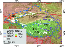
Fig. 1
Overview of glacier zoning in Central Asia"

Tab. 1
Normal distribution test of ICESat foot elevation in area I in 2003"
| Kolmogorov-Smirova检验 | Shapiro-Wilk检验 | |||||
|---|---|---|---|---|---|---|
| 统计 | 自由度 | 显著性 | 统计 | 自由度 | 显著性 | |
| 0.041 | 1483 | 0.000 | 0.983 | 1483 | 0.000 | |
Fig. 2
Comparison of data in zone I before and after removing outliers in 2003"

Tab. 2
R2of the polynomial fitting model from 2003 to March 2009 in the study area"
| 年份 | 整体 | Ⅰ区 | Ⅱ区 | Ⅲ区 |
|---|---|---|---|---|
| 2003 | 0.9951 | 0.9866 | 0.9974 | 0.9916 |
| 2004 | 0.9990 | 0.9995 | 0.9994 | 0.9959 |
| 2005 | 0.9964 | 0.9924 | 0.9980 | 0.9963 |
| 2006 | 0.9987 | 0.9979 | 0.9992 | 0.9975 |
| 2007 | 0.9985 | 0.9994 | 0.9997 | 0.9932 |
| 2008 | 0.9995 | 0.9988 | 0.9998 | 0.9989 |
| 2009 | 0.9999 | 0.9999 | 0.9999 | 0.9998 |
Tab. 3
Average variation of glacier surface elevation in different periods of time in each region"
| 时段 | 整体/m | Ⅰ区/m | Ⅱ区/m | Ⅲ区/m |
|---|---|---|---|---|
| 2003—2004年 | -5.89±3.76 | -5.78±2.13 | -3.53±2.99 | -4.82±3.31 |
| 2004—2005年 | 6.13±3.91 | 1.79±1.44 | 8.13±5.52 | 1.83±0.52 |
| 2005—2006年 | -3.78±2.66 | -1.12±1.01 | -6.71±5.24 | -2.02±1.68 |
| 2006—2007年 | -3.56±2.79 | -0.35±0.30 | -4.61±3.31 | -0.03±1.89 |
| 2007—2008年 | -1.97±1.04 | -0.63±0.60 | 0.43±0.32 | -4±3.53 |
| 2008—2009年 | -0.52±0.38 | -0.42±0.29 | -1.58±1.41 | -0.77±0.64 |
| 2003—2009年 | -9.59±1.89 | -6.51±2.9 | -7.87±5.03 | -9.81±5.1 |

Fig. 3
Time series reconstruction of glacier surface elevation change in each study area"


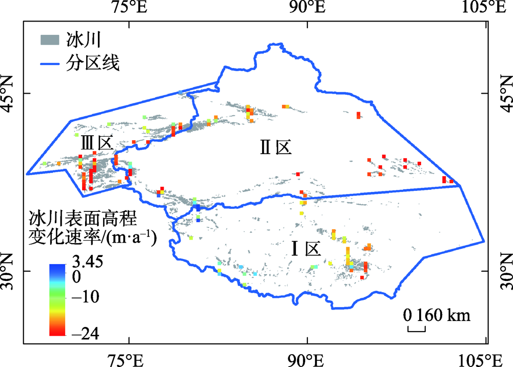
Fig. 4
Distribution map of glacier surface change rate in each region"
| [1] |
Bocchiola D, G Diolaiuti. Recent (1980-2009) evidence of climate change in the upper Karakoram Pakistan[J]. Theoretical and Applied Climatology, 2013, 113(3-4): 611-641.
doi: 10.1007/s00704-012-0803-y |
| [2] |
Treichler D, Kääb A, Salzmann N, et al. Recent glacier and lake changes in high mountain Asia and their relation to precipitation changes[J]. The Cryosphere, 2019, 13(11): 2977-3005.
doi: 10.5194/tc-13-2977-2019 |
| [3] |
Hugonnet R, McNabb R, Berthier E, et al. Accelerated global glacier mass loss in the early twenty-first century[J]. Nature, 2021, 592(7856): 726.
doi: 10.1038/s41586-021-03436-z |
| [4] |
Farinotti D, Immerzeel W W, de Kok R J, et al. Manifestations and mechanisms of the Karakoram glacier anomaly[J]. Nature Geoscience, 2020, 13(1): 8.
doi: 10.1038/s41561-019-0513-5 pmid: 31915463 |
| [5] | 吴珊珊, 姚治君, 姜丽光, 等. 现代冰川体积变化研究方法综述[J]. 地球科学进展, 2015, 30(2): 237-246. |
| [ Wu Shanshan, Yao Zhijun, Jiang Liguang, et al. Review on the research methods of modern glacier volume change[J]. Advances in Earth Science, 2015, 30(2): 237-246. ] | |
| [6] |
Zhao X R, Wang X, Wei J F, et al. Spatiotemporal variability of glacier changes and their controlling factors in the Kanchenjunga region Himalaya based on multi-source remote sensing data from 1975 to 2015[J]. Science of the Total Environment, 2020, 745: 140995, doi: 10.1016/j.scitotenv.2020.140995.
doi: 10.1016/j.scitotenv.2020.140995 |
| [7] |
Huang T J, Jia L, Menenti M, et al. A new method to estimate changes in glacier surface elevation based on polynomial fitting of sparse ICESat-GLAS Footprints[J]. Sensors, 2017, 17(8): 1803, doi: 10.3390/s17081803.
doi: 10.3390/s17081803 |
| [8] |
Nuth C, Moholdt G, Kohler J, et al. Svalbard glacier elevation changes and contribution to sea level rise[J]. Journal of Geophysical Research: Earth Surface, 2010, 115(F1), doi: 10.1029/2008JF001223.
doi: 10.1029/2008JF001223 |
| [9] | Kääb A, Berthier E, Nuth C, et al. Contrasting patterns of early twenty-first-century glacier mass change in the Himalayas[J]. Nature: International Weekly Journal of Science, 2012, 488(7412): 495-498. |
| [10] | 杜小平, 郭华东, 范湘涛, 等. 基于ICESat/GLAS数据的中国典型区域SRTM与ASTER GDEM高程精度评价[J]. 地球科学, 2013, 38(4): 887-897. |
| [ Du Xiaoping, Guo Huadong, Fan Xiangtao, et al. Elevation accuracy evaluation of SRTM and aster GDEM in typical regions of China based on ICESat/GLAS data[J]. Journal of Earth Science, 2013, 38(4): 887-897. ] | |
| [11] | 宗继彪, 叶庆华, 田立德. 基于ICESat/GLAS, SRTM DEM和GPS观测青藏高原纳木那尼冰面高程变化(2000-2010年)[J]. 科学通报, 2014, 59(21): 2108-2118. |
| [ Zong Jibiao, Ye Qinghua, Tian Lide. Observation of elevation change of namunani ice surface on Qinghai Tibet Plateau based on ICESat/GLAS, SRTM DEM and GPS (2000-2010)[J]. Chinese Science Bulletin, 2014, 59(21): 2108-2118. ] | |
| [12] | 米玛卓嘎, 秦增良, 肖卓靖, 等. 西藏夏季降水特征及其预测分析[J]. 干旱区研究, 2019, 36(5): 1060-1069. |
| [ Mirmah Zhuoga, Qin Zengliang, Xiao Zhuojing, et al. Summer precipitation in Tibet and its prediction[J]. Arid Zone Research, 2019, 36(5): 1060-1069. ] | |
| [13] | 杨昭明, 张调风. 1961-2017年青藏高原东北部雨季降水量变化及其贡献度分析[J]. 干旱区研究, 2021, 38(1): 22-28. |
| [ Yang Zhaoming, Zhang Tiaofeng. Analysis of precipitation change and its contribution in the rainy season in the northeast Qinghai-Tibet Plateau from 1961 to 2017[J]. Arid Zone Research, 2021, 38(1): 22-28. ] | |
| [14] | 陈丽娟, 许力, 江滢. 2004年北半球大气环流及对中国气候异常的影响[J]. 气象, 2005, 31(4): 27-31. |
| [ Chen Lijuan, Xu Li, Jiang Ying. Atmospheric circulation in the northern hemisphere in 2004 and its impact on climate anomalies in China[J]. Meteorological Monthly, 2005, 31(4): 27-31. ] | |
| [15] | 博尔楠·哈不都拉, 恰里哈尔, 阿衣敏. 2004年全国夏季降水异常及其成因[J]. 安徽农业科学, 2014, 42(16): 5159-5160. |
| [ Bornan Habura, Chariha, Aymin. Summer precipitation anomaly and its causes in China in 2004[J]. Journal of Anhui Agricultural Sciences, 2014, 42(16): 5159-5160. ] | |
| [16] | 孙建华, 卫捷, 赵思雄, 等. 2005年夏季的主要天气及其环流分析[J]. 气候与环境研究, 2006, 11(2): 138-154. |
| [ Sun Jianhua, Wei Jie, Zhao Sixiong, et al. Analysis of main weather and circulation in summer of 2005[J]. Climatic and Environmental Research, 2006, 11(2): 138-154. ] | |
| [17] | 杨莲梅, 史玉光, 汤浩. 新疆北部冬季降水异常成因[J]. 应用气象学报, 2010, 21(4): 491-499. |
| [ Yang Lianmei, Shi Yuguang, Tang Hao. Causes of winter precipitation anomaly in Northern Xinjiang[J]. Journal of Applied Meteorological Science, 2010, 21(4): 491-499. ] | |
| [18] | 蒋宗立, 王磊, 张震, 等. 2000-2014年喀喇昆仑山音苏盖提冰川表面高程变化[J]. 干旱区地理, 2020, 43(1): 12-19. |
| [ Jiang Zongli, Wang Lei, Zhang Zheng, et al. Surface elevation change of Yinsugeti glacier in Karakoram mountain from 2000 to 2014[J]. Arid Land Geography, 2020, 43(1): 12-19. ] | |
| [19] |
傅抱璞. 地形和海拔高度对降水的影响[J]. 地理学报, 1992, 47(4): 302-314.
doi: 10.11821/xb199204002 |
|
[ Fu Baopu. Influence of topography and altitude on precipitation[J]. Acta Geographica Sinica, 1992, 47(4): 302-314. ]
doi: 10.11821/xb199204002 |
|
| [20] | 陶静, 赵文吉, 王旭, 等. 念青唐古拉山西段冰湖时空变化分析[J]. 干旱区研究, 2021, 38(3): 618-628. |
| [ Tao Jing, Zhao Wenji, Wang Xu, et al. Spatial changes of the glacial lakes in the western Nyainqentanglha Range[J]. Arid Zone Research, 2021, 38(3): 618-628. ] | |
| [21] | 赵美亮, 曹广超, 曹生奎, 等. 1980-2017年青海省地表温度时空变化特征[J]. 干旱区研究, 2021, 38(1): 178-187. |
| [ Zhao Meiliang, Cao Guangchao, Cao Shengkui, et al. Spatial-temporal variation characteristics of land surface temperature in Qinghai Province from 1980 to 2017[J]. Arid Zone Research, 2021, 38(1): 178-187. ] | |
| [22] | 曾磊, 杨太保, 田洪阵. 近40年东帕米尔高原冰川变化及其对气候的响应[J]. 干旱区资源与环境, 2013, 27(5): 144-150. |
| [ Zeng Lei, Yang Taibao, Tian Hongzhen. Glacier change in the East Pamir Plateau in recent 40 years and its response to climate[J]. Journal of Arid Land Resources and Environment, 2013, 27(5): 144-150. ] |
|
||