Arid Zone Research ›› 2025, Vol. 42 ›› Issue (10): 1813-1827.doi: 10.13866/j.azr.2025.10.06
• Land and Water Resources • Previous Articles Next Articles
SONG Haiqing1,2( ), HUANG Yan3(), SUN Xiaolong1,2
Received:2025-03-19
Revised:2025-07-01
Online:2025-10-15
Published:2025-10-22
Contact:
HUANG Yan
E-mail:haiqingsong@emails.imau.edu.cn;yan304@163.com
SONG Haiqing, HUANG Yan, SUN Xiaolong. Applicability evaluation of five soil texture datasets to surface soil moisture simulations based on IMLDAS[J].Arid Zone Research, 2025, 42(10): 1813-1827.
Add to citation manager EndNote|Reference Manager|ProCite|BibTeX|RefWorks
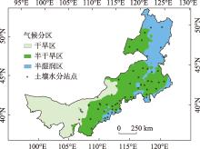
Fig. 1
Inner Mongolia climatic division areas and distribution of soil moisture observation sites"

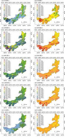
Fig. 2
Distribution of sand and clay from five soil texture datasets in Inner Mongolia (0-30 cm)"

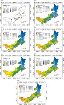
Fig. 3
Spatial distribution of the observed 0-10 cm soil moisture (a) and six simulated mean soil moisture (b-g) of 2016-2020"

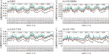
Fig. 4
Time series of 10-days averaged volumetric soil moisture of May-September 2016-2020 from the observations and five simulations in Inner Mongolia and its three climate sub-regions"

Tab. 1
R, MAE, RMSE and KGE between simulated soil moisture and 0-10 cm observed data in Inner Mongolia and its three climate sub-regions"
| 区域 | CLDAS | FAO | BNU | |||||||||||
|---|---|---|---|---|---|---|---|---|---|---|---|---|---|---|
| R | MAE /(m3·m-3) | RMSE /(m3·m-3) | KGE | R | MAE /(m3·m-3) | RMSE /(m3·m-3) | KGE | R | MAE /(m3·m-3) | RMSE /(m3·m-3) | KGE | |||
| 内蒙古 | 0.816 | 0.081 | 0.082 | 0.317 | 0.818 | 0.069 | 0.070 | 0.430 | 0.836 | 0.042 | 0.044 | 0.621 | ||
| 区内半 湿润区 | 0.780 | 0.0701 | 0.074 | 0.556 | 0.814 | 0.062 | 0.065 | 0.592 | 0.805 | 0.028 | 0.032 | 0.709 | ||
| 区内半 干旱区 | 0.823 | 0.085 | 0.086 | 0.226 | 0.876 | 0.072 | 0.072 | 0.379 | 0.887 | 0.047 | 0.048 | 0.567 | ||
| 区内干 旱区 | 0.505 | 0.070 | 0.075 | 0.198 | 0.250 | 0.068 | 0.072 | -0.018 | 0.375 | 0.045 | 0.050 | 0.200 | ||
| 区域 | CAS | GSDE | SNSS | |||||||||||
| R | MAE /(m3·m-3) | RMSE /(m3·m-3) | KGE | R | MAE /(m3·m-3) | RMSE /(m3·m-3) | KGE | R | MAE /(m3·m-3) | RMSE /(m3·m-3) | KGE | |||
| 内蒙古 | 0.841 | 0.049 | 0.051 | 0.564 | 0.835 | 0.044 | 0.045 | 0.610 | 0.855 | 0.034 | 0.036 | 0.687 | ||
| 区内半 湿润区 | 0.822 | 0.038 | 0.042 | 0.706 | 0.806 | 0.029 | 0.033 | 0.714 | 0.815 | 0.019 | 0.023 | 0.734 | ||
| 区内半 干旱区 | 0.888 | 0.054 | 0.056 | 0.490 | 0.886 | 0.048 | 0.049 | 0.551 | 0.900 | 0.041 | 0.042 | 0.616 | ||
| 区内干 旱区 | 0.413 | 0.042 | 0.046 | 0.231 | 0.383 | 0.044 | 0.049 | 0.211 | 0.477 | 0.032 | 0.037 | 0.327 | ||
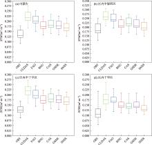
Fig. 5
Box-plot of mean of observed soil moisture, CLDAS and five simulations"

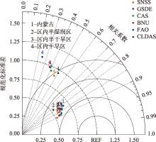
Fig. 6
Taylor diagrams of CLDAS and five simulated soil moisture datasets of May-September 2016-2020 in Inner Mongolia and its three climate sub-regions"

| [1] |
周广胜, 周梦子, 周莉, 等. 陆-气相互作用研究展望[J]. 地球科学进展, 2024, 39(7): 661-670.
doi: 10.11867/j.issn.1001-8166.2024.045 |
|
[Zhou Guangsheng, Zhou Mengzi, Zhou Li, et al. Prospects for land-atmosphere interaction[J]. Advances in Earth Science, 2024, 39(7): 661-670. ]
doi: 10.11867/j.issn.1001-8166.2024.045 |
|
| [2] | Santanello Jr J A, Dirmeyer P A, Ferguson C R, et al. Land-atmosphere interactions: The LoCo perspective[J]. Bulletin of the American Meteorological Society, 2018, 99(6): 1253-1272. |
| [3] | 林朝晖, 刘辉志, 谢正辉, 等. 陆面水文过程研究进展[J]. 大气科学, 2008, 32(4): 935-949. |
| [Lin Zhaohui, Liu Huizhi, Xie Zhenghui, et al. Recent progress in the land-surface and hydrological process studies[J]. Chinese Journal of Atmospheric Sciences, 2008, 32(4): 935-949. ] | |
| [4] | Chahine T M. The hydrological cycle and its influence on climate[J]. Nature, 1992, 359: 373-380. |
| [5] | Santanello J A, Kumar S V, Peters-Lidard C D, et al. Impact of soil moisture assimilation on land surface model spin-up and coupled land-atmosphere prediction[J]. Journal of Hydrometeorology, 2016, 17(2): 517-540. |
| [6] |
Ferguson C R, Agrawal S, Beauharnois M C, et al. Assimilation of satellite-derived soil moisture for improved forecasts of the Great Plains low-level jet[J]. Monthly Weather Review, 2020, 148(11): 4607-4627.
doi: 10.1175/MWR-D-20-0185.1 |
| [7] |
陈海山, 杜新观, 孙悦. 陆面过程与天气研究[J]. 地学前缘, 2022, 29(5): 382-400.
doi: 10.13745/j.esf.sf.2021.9.59 |
|
[Chen Haishan, Du Xinguan, Sun Yue. Land surface processes and weather research—a review[J]. Earth Science Frontiers, 2022, 29(5): 382-400. ]
doi: 10.13745/j.esf.sf.2021.9.59 |
|
| [8] |
薛智暄, 张丽, 王新军, 等. 古尔班通古特沙漠SMAP土壤水分产品降尺度分析[J]. 干旱区研究, 2023, 40(4): 583-593.
doi: 10.13866/j.azr.2023.04.07 |
|
[Xue Zhixuan, Zhang Li, Wang Xinjun, et al. Downscaling analysis of SMAP soil moisture products in Gurbantunggut Desert[J]. Arid Zone Research, 2023, 40(4): 583-593. ]
doi: 10.13866/j.azr.2023.04.07 |
|
| [9] | 宋海清, 朱仲元, 李云鹏. 6套格点土壤水分数据集在内蒙古自治区的适用性评价[J]. 水土保持通报, 2022, 41(6): 180-189, 200. |
| [Song Haiqing, Zhu Zhongyuan, Li Yunpeng. Applicability evaluation of six gridded soil moisture datasets in Inner Mongolia Autonomous Region[J]. Bulletin of Soil and Water Conservation, 2022, 41(6): 180-189, 200. ] | |
| [10] | 熊明明, 陈海山, 俞淼. CLM3.0对中国区域陆面过程的模拟试验及评估Ⅱ: 土壤湿度[J]. 气象科学, 2011, 31(1): 1-10. |
| [Xiong Mingming, Chen Haishan, Yu Miao. Simulation of land surface processes over China and its validation. PartⅡ: Soil moisture[J]. Journal of the Meteorological Sciences, 2011, 31(1): 1-10. ] | |
| [11] | Li Mingxing, Ma Zhuguo, Niu Guoyue. Modeling spatial and temporal variations in soil moisture in China[J]. Chinese Science Bulletin, 2011, 56(17): 1809-1820. |
| [12] | 王迪, 沈润平, 师春香, 等. CLM4.5对中国区域夏季土壤湿度的模拟研究[J]. 科学技术与工程, 2015, 15(17): 10-17. |
| [Wang Di, Shen Runping, Shi Chunxiang, et al. Simulation for China’s soil moisture by CLM4.5 in summer season[J]. Science Technology and Engineering, 2015, 15(17): 10-17. ] | |
| [13] | 韩帅, 师春香, 姜立鹏, 等. CLDAS土壤湿度模拟结果及评估[J]. 应用气象学报, 2017, 28(3): 369-378. |
| [Han Shuai, Shi Chunxiang, Jiang Lipeng, et al. The simulation and evaluation of soil moisture based on CLDAS[J]. Journal of Applied Meteorological Science, 2017, 28(3): 369-378. ] | |
| [14] | 师春香, 姜立鹏, 朱智, 等. 基于CLDAS2.0驱动数据的中国区域土壤湿度模拟与评估[J]. 江苏农业科学, 2018, 46(4): 231-236. |
| [Shi Chunxiang, Jiang Lipeng, Zhu Zhi, et al. Simulation and assessment of China’s regional soil moisture based on CLDAS2.0 forcing data[J]. Jiangsu Agricultural Sciences, 2018, 46(4): 231-236. ] | |
| [15] | Xia Y, Ek M B, Wu Y, et al. Comparison of NLDAS-2 simulated and NASMD observed daily soil moisture Part I: Comparison and analysis[J]. Journal of Hydrometeorology, 2015, 16(5): 1962-1980. ] |
| [16] | 吴龙刚, 王爱慧, 盛炎平. 土壤质地对中国区域陆面过程模拟的影响[J]. 气候与环境研究, 2014, 19(5): 559-571. |
| [Wu Longgang, Wang Aihui, Sheng Yanping. Impact of soil texture on the simulation of land surface processes in China[J]. Climatic and Environmental Research, 2014, 19(5): 559-571. ] | |
| [17] | 梁晓, 戴永久. 通用陆面模式对土壤质地和亮度的敏感性分析[J]. 气候与环境研究, 2008, 13(5): 585-597. |
| [Liang Xiao, Dai Yongjiu. A sensitivity study of the common land model on soil texture and soil brightness[J]. Climatic and Environmental Research, 2008, 13(5): 585-597. ] | |
| [18] | 戴秋丹, 郭振海, 王龙欢, 等. CLM4.5模式模拟安徽省淮南山地森林陆气交换过程[J]. 大气科学, 2025, 49(1): 23-37. |
| [Dai Qiudan, Guo Zhenhai, Wang Longhuan, et al. Simulating land and atmosphere exchange processes over a mountainous forest in Huainan of Anhui Province using CLM4.5 model[J]. Chinese Journal of Atmospheric Sciences, 2025, 49(1): 23-37. ] | |
| [19] | 李文耀, 魏楠, 黄丽娜, 等. 土壤数据集对全球陆面过程模拟的影响[J]. 气候与环境研究, 2020, 25(5): 555-574. |
| [Li Wenyao, Wei Nan, Huang Lina, et al. Impact of soil datasets on the global simulation of land surface processes[J]. Climatic and Environmental Research, 2020, 25(5): 555-574. ] | |
| [20] | Lazić I, Djurdjević V, Tošić I, et al. Impact of soil texture in coupled regional climate model on land-atmosphere interactions[J]. Theoretical and Applied Climatology, 2025, 156(165): 1-23. |
| [21] | Livneh B, Kumar R, Samaniego L. Influence of soil textural properties on hydrologic fluxes in the Mississippi River Basin[J]. Hydrological Processes, 2015, 29(21): 4638-4655. |
| [22] | Dy C Y, Fung J C H. Updated global soil map for the weather research and forecasting model and soil moisture initialization for the Noah land surface model[J]. Journal of Geophysical Research: Atmospheres, 2016, 121(15): 8777-8800. |
| [23] | 宋海清, 李云鹏, 师春香, 等. 内蒙古地区下垫面变化对土壤湿度数值模拟的影响[J]. 大气科学, 2016, 40(6): 1165-1181. |
| [Song Haiqing, Li Yunpeng, Shi Chunxiang, et al. Impact of underlying surface change on the numerical simulation of soil moisture in Inner Mongolia of China[J]. Chinese Journal of Atmospheric Sciences, 2016, 40(6): 1165-1181. ] | |
| [24] | 顾润源. 内蒙古自治区天气预报手册[M]. 北京: 气象出版社, 2012. |
| [Gu Runyuan. Inner Mongolia Weather Forecast Manual[M]. Beijing: China Meteorological Press, 2012. ] | |
| [25] | Reynolds C A, Jackson T J, Rawls W J. Estimating soil water-holding capacities by linking the Food and Agriculture Organization soil map of the world with global pedon databases and continuous pedotransfer functions[J]. Water Resources Research, 2000, 36(12): 3653-3662. |
| [26] | Oleson K W, Niu G Y, Yang Z L, et al. Improvements to the community land model and their impact on the hydrological cycle[J]. Journal of Geophysical Research: Biogeosciences, 2008, 113(G01021): 1-26. |
| [27] | Shangguan W, Dai Y, Liu B, et al. A China data set of soil properties for land surface modeling[J]. Journal of Advances in Modeling Earth Systems, 2013, 5(2): 212-224. |
| [28] |
Liu F, Wu H, Zhao Y, et al. Mapping high resolution national soil information grids of China[J]. Science Bulletin, 2022, 67(3): 328-340.
doi: 10.1016/j.scib.2021.10.013 pmid: 36546081 |
| [29] | Shangguan W, Dai Y, Duan Q, et al. A global soil data set for earth system modeling[J]. Journal of Advances in Modeling Earth Systems, 2014, 6(1): 249-263. |
| [30] | Shangguan W, Dai Y, Liu B, et al. A soil particle-size distribution dataset for regional land and climate modelling in China[J]. Geoderma, 2012, 171: 85-91. |
| [31] | Yang F, Lu H, Yang K, et al. Evaluation and comparison among multiple forcing data sets for precipitation and shortwave radiation over the mainland of China[J]. Hydrology and Earth System Sciences Discussions, 2017, 21(11): 1-32. |
| [32] | 宋海清. 内蒙古中东部草原区土壤水热过程对区域天气的影响研究[D]. 呼和浩特: 内蒙古农业大学, 2021. |
| [Song Haiqing. Effects of Soil Water and Heat Processes on Regional Weather in Central and Eastern Inner Mongolia Grassland[D]. Hohhot: Inner Mongolia Agricultural University, 2021. ] | |
| [33] | He J, Yang K, Tang W, et al. The first high-resolution meteorological forcing dataset for land process studies over China[J]. Scientific Data, 2020, 7(25): 1-11. |
| [34] |
宋海清, 朱仲元, 李云鹏. 陆面同化及再分析降水资料在内蒙古地区的适用性[J]. 干旱区研究, 2021, 38(6): 1624-1636.
doi: 10.13866/j.azr.2021.06.14 |
|
[Song Haiqing, Zhu Zhongyuan, Li Yunpeng. Validation of land data assimilation and reanalysis precipitation datasets over Inner Mongolia[J]. Arid Zone Research, 2021, 38(6): 1624-1636. ]
doi: 10.13866/j.azr.2021.06.14 |
|
| [35] |
刘川, 余晔, 解晋, 等. 多套土壤温湿度资料在青藏高原的适用性[J]. 高原气象, 2015, 34(3): 653-665.
doi: 10.7522/j.issn.1000-0534.2015.00034 |
|
[Liu Chuan, Yu Ye, Xie Jin, et al. Applicability of soil temperature and moisture in several datasets over Qinghai-Xizang Plateau[J]. Plateau Meteorology, 2015, 34(3): 653-665. ]
doi: 10.7522/j.issn.1000-0534.2015.00034 |
|
| [36] | Taylor K E. Summarizing multiple aspects of model performance in a single diagram[J]. Journal of Geophysical Research: Atmospheres, 2001, 106(D7): 7183-7192. |
| [39] |
[Yang Yaqing, Zhang Chong, Zhang Jie, et al. Changes in soil moisture and dryness and their response to climate change in the Guanzhong region[J]. Arid Zone Research, 2024, 41(2): 261-271. ]
doi: 10.13866/j.azr.2024.02.09 |
| [37] | Decker M, Zeng X. Impact of modified Richards equation on global soil moisture simulation in the Community Land Model (CLM3.5)[J]. Journal of Advances in Modeling Earth Systems, 2009, 1(5): 1-22. |
| [38] | 赖欣, 文军, 岑思弦, 等. CLM4.0模式对中国区域土壤湿度的数值模拟及评估研究[J]. 大气科学, 2014, 38(3): 499-512. |
| [Lai Xin, Wen Jun, Cen Sixian, et al. Numerical simulation and evaluation study of soil moisture over China by using CLM4.0 model[J]. Chinese Journal of Atmospheric Sciences, 2014, 38(3): 499-512. ] | |
| [39] |
杨雅青, 张翀, 张婕, 等. 关中地区土壤干湿变化及对气候的响应[J]. 干旱区研究, 2024, 41(2): 261-271.
doi: 10.13866/j.azr.2024.02.09 |
|
||