Arid Zone Research ›› 2025, Vol. 42 ›› Issue (1): 40-50.doi: 10.13866/j.azr.2025.01.04
• Land and Water Resources • Previous Articles Next Articles
ZOU Bin1,2( ), ZOU Shan2,3,4(), YANG Yuhui1
Received:2024-10-06
Revised:2024-11-08
Online:2025-01-15
Published:2025-01-17
Contact:
ZOU Shan
E-mail:zoubin0304@163.com;zoushan@ms.xjb.ac.cn
ZOU Bin, ZOU Shan, YANG Yuhui. Dynamic changes and driving factors of surface water body in Xinjiang from 1990 to 2023[J].Arid Zone Research, 2025, 42(1): 40-50.
Add to citation manager EndNote|Reference Manager|ProCite|BibTeX|RefWorks

Fig. 1
Map of study area"


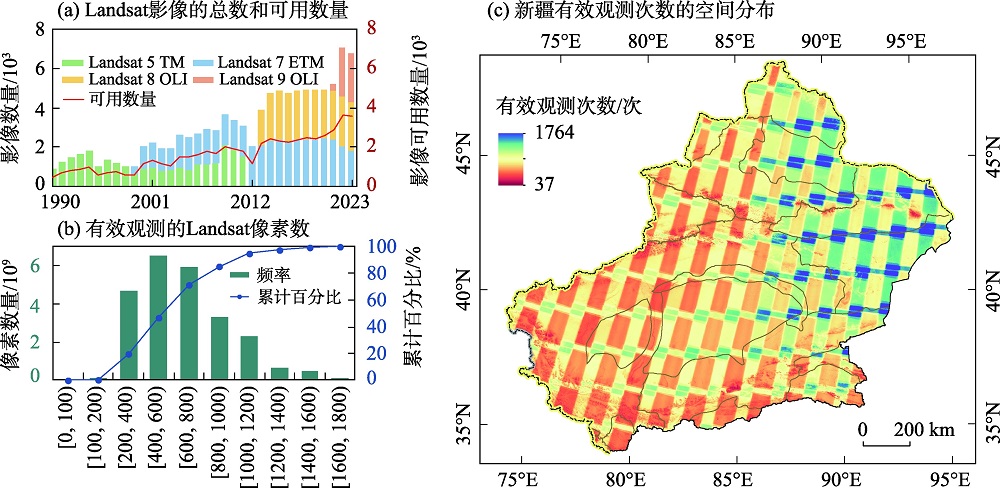
Fig. 2
Spatiotemporal distribution of Landsat image coverage in Xinjiang from 1990 to 2023"
Tab. 1
The confusion matrix for accuracy assessment of this study"
| Sentinel-2A 目视解译结果 | 提取结果 | 总计/个 | 用户精度 | |
|---|---|---|---|---|
| 水体/个 | 非水体/个 | |||
| 水体 | 1098 | 47 | 1145 | 95.90% |
| 非水体 | 68 | 6787 | 6855 | 99.01% |
| 总计 | 1166 | 6834 | 8000 | 总体精度=98.57% |
| 生产者精度 | 94.17% | 99.31% | Kappa系数=94.18% | |
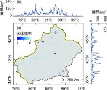
Fig. 3
Spatial distribution of (a) water body frequency and total surface water area along (b) longitude and (c) latitude in Xinjiang from 1990 to 2023"

Fig. 4
SD and Cv values of (a) permanent and (b) seasonal water body in each river basin in Xinjiang from 1990 to 2023 and their proportions in surface water body"
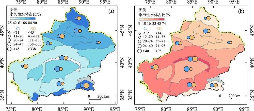

Fig. 5
Change trends in surface water body of the river basin and its mountains, oasis-deserts"
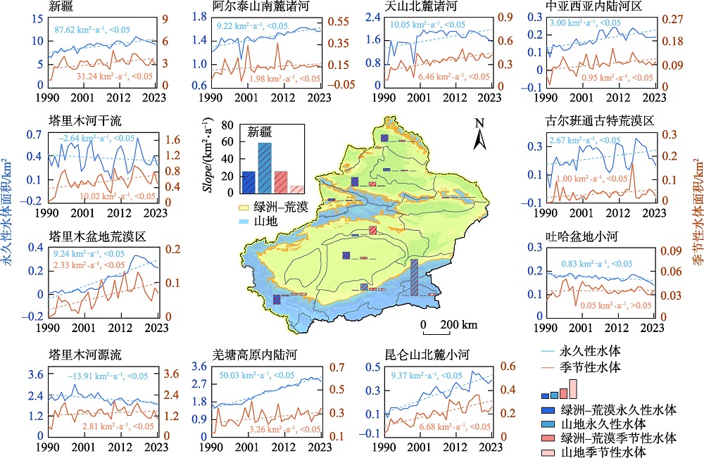
Fig. 6
Contribution rate of influencing factors in each watershed"
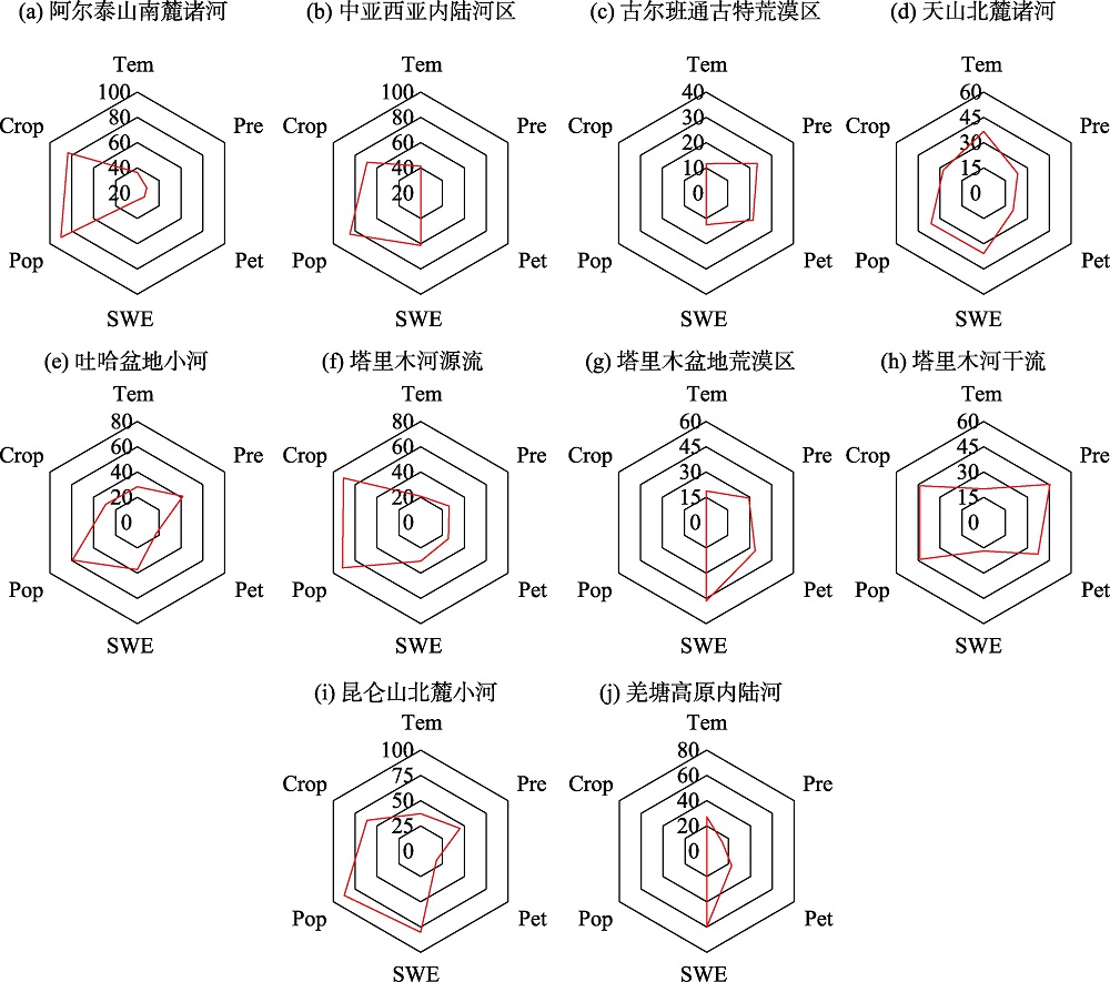
Fig. 7
Contribution rates of influencing factors for mountain and oasis-desert water body in each river basin"


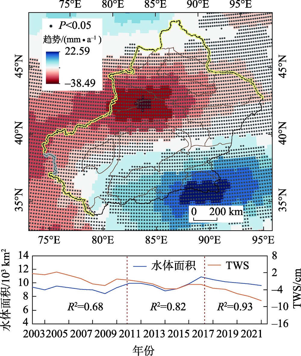
Fig. 8
Change trend of terrestrial water reserves in Xinjiang and comparison with surface water bodies"
| [1] | Pekel J F, Cottam A, Gorelick N, et al. High-resolution mapping of global surface water and its long-term changes[J]. Nature, 2016, 540(7633): 418-422. |
| [2] |
Hall J W, Grey D, Garrick D, et al. Coping with the curse of freshwater variability[J]. Science, 2014, 346(6208): 429-430.
doi: 10.1126/science.1257890 pmid: 25342791 |
| [3] | Vörösmarty C J, McIntyre P B, Gessner M O, et al. Global threats to human water security and river biodiversity[J]. Nature, 2010, 467(7315): 555-561. |
| [4] |
姚俊强. 新疆空中水资源和地表水资源变化特征研究[J]. 干旱区研究, 2024, 41(2): 181-190.
doi: 10.13866/j.azr.2024.02.01 |
|
[Yao Junqiang. Change in atmospheric and surface water resource in Xinjiang[J]. Arid Zone Research, 2024, 41(2): 181-190. ]
doi: 10.13866/j.azr.2024.02.01 |
|
| [5] | Yao J, Chen Y, Guan X, et al. Recent climate and hydrological changes in a mountain-basin system in Xinjiang, China[J]. Earth-Science Reviews, 2022, 226: 103957. |
| [6] | Shen Y J, Shen Y, Guo Y, et al. Review of historical and projected future climatic and hydrological changes in mountainous semiarid Xinjiang (northwestern China), Central Asia[J]. CATENA, 2020, 187: 104343. |
| [7] | Lu H, Zhao R, Zhao L, et al. A contrarian growth: The spatiotemporal dynamics of open-surface water bodies on the northern slope of Kunlun Mountains[J]. Ecological Indicators, 2023, 157: 111249. |
| [8] | Zheng L, Xia Z, Xu J, et al. Exploring annual lake dynamics in Xinjiang (China): Spatiotemporal features and driving climate factors from 2000 to 2019[J]. Climatic Change, 2021, 166(3): 36. |
| [9] |
邹珊, 吉力力·阿不都外力, 黄文静, 等. 塔里木河下游生态输水对地表水体面积变化的影响[J]. 干旱区地理, 2021, 44(3): 681-690.
doi: 10.12118/j.issn.1000–6060.2021.03.10 |
|
[Zou Shan, Jilili Abuduwaili, Huang Wenjing, et al. Effects of ecological water conveyance on changes of surface water area in the lower reaches of Tarim River[J]. Arid Land Geography, 2021, 44(3): 681-690. ]
doi: 10.12118/j.issn.1000–6060.2021.03.10 |
|
| [10] | Alsdorf D E, Rodríguez E, Lettenmaier D P. Measuring surface water from space[J]. Reviews of Geophysics, 2007, 45(2): 1-24. |
| [11] | Liu X, Hu G, Chen Y, et al. High-resolution multi-temporal mapping of global urban land using Landsat images based on the Google Earth Engine Platform[J]. Remote Sensing of Environment, 2018, 209: 227-239. |
| [12] | Wang X, Xiao X, Zou Z, et al. Gainers and losers of surface and terrestrial water resources in China during 1989-2016[J]. Nature Communications, 2020, 11(1): 3471. |
| [13] | Huang C, Chen Y, Zhang S, et al. Detecting, extracting, and monitoring surface water from space using optical sensors: A review[J]. Reviews of Geophysics, 2018, 56(2): 333-360. |
| [14] | McFeeters S K. The use of the Normalized Difference Water Index (NDWI) in the delineation of open water features[J]. International Journal of Remote Sensing, 1996, 17(7): 1425-1432. |
| [15] | Xu H. Modification of normalised difference water index (NDWI) to enhance open water features in remotely sensed imagery[J]. International Journal of Remote Sensing, 2006, 27(14): 3025-3033. |
| [16] | Sun F, Sun W, Chen J, et al. Comparison and improvement of methods for identifying waterbodies in remotely sensed imagery[J]. International Journal of Remote Sensing, 2012, 33(21): 6854-6875. |
| [17] | Gómez C, White J C, Wulder M A. Optical remotely sensed time series data for land cover classification: A review[J]. ISPRS Journal of Photogrammetry and Remote Sensing, 2016, 116: 55-72. |
| [18] | Khatami R, Mountrakis G, Stehman S V. A meta-analysis of remote sensing research on supervised pixel-based land-cover image classification processes: General guidelines for practitioners and future research[J]. Remote Sensing of Environment, 2016, 177: 89-100. |
| [19] |
Chen Y, Li Z, Fan Y, et al. Progress and prospects of climate change impacts on hydrology in the arid region of Northwest China[J]. Environmental Research, 2015, 139: 11-19.
doi: 10.1016/j.envres.2014.12.029 pmid: 25682220 |
| [20] | Abatzoglou J T, Dobrowski S Z, Parks S A, et al. TerraClimate, a high-resolution global dataset of monthly climate and climatic water balance from 1958-2015[J]. Scientific Data, 2018, 5(1): 170191. |
| [21] |
Yang J, Huang X. The 30 m annual land cover dataset and its dynamics in China from 1990 to 2019[J]. Earth System Science Data, 2021, 13(8): 3907-3925.
doi: 10.5194/essd-13-3907-2021 |
| [22] |
Tapley B D, Bettadpur S, Ries J C, et al. GRACE measurements of mass variability in the earth system[J]. Science, 2004, 305(5683): 503-505.
doi: 10.1126/science.1099192 pmid: 15273390 |
| [23] | Zou Z, Xiao X, Dong J, et al. Divergent trends of open-surface water body area in the contiguous United States from 1984 to 2016[J]. Proceedings of the National Academy of Sciences, 2018, 115(15): 3810-3815. |
| [24] | Huang W, Duan W, Nover D, et al. An integrated assessment of surface water dynamics in the Irtysh River Basin during 1990-2019 and exploratory factor analyses[J]. Journal of Hydrology, 2021, 593: 125905. |
| [25] | Huang W, Duan W, Chen Y. Unravelling lake water storage change in Central Asia: Rapid decrease in tail-end lakes and increasing risks to water supply[J]. Journal of Hydrology, 2022, 614: 128546. |
| [26] | Zhou H, Liu S, Hu S, et al. Retrieving dynamics of the surface water extent in the upper reach of Yellow River[J]. Science of The Total Environment, 2021, 800: 149348. |
| [27] | Zou Z, Dong J, Menarguez M A, et al. Continued decrease of open surface water body area in Oklahoma during 1984-2015[J]. Science of The Total Environment, 2017, 595: 451-460. |
| [28] | Chen J, Kang T, Yang S, et al. Open-Surface water bodies dynamics analysis in the Tarim River Basin (North-Western China), based on Google Earth Engine cloud platform[J]. Water, 2020, 12(10): 2822. |
| [29] |
李崇巍, 王志慧, 汤秋鸿, 等. 1986—2019年黄河流域地表水体动态变化及其影响因素[J]. 地理学报, 2022, 77(5): 1153-1168.
doi: 10.11821/dlxb202205008 |
|
[Li Chongwei, Wang Zhihui, Tang Qiuhong, et al. Dynamics of surface water area in the Yellow River Basin and its influencing mechanism during 1986-2019 based on Google Earth Engine[J]. Acta Geographica Sinica, 2022, 77(5): 1153-1168. ]
doi: 10.11821/dlxb202205008 |
|
| [30] | Olofsson P, Foody G M, Herold M, et al. Good practices for estimating area and assessing accuracy of land change[J]. Remote Sensing of Environment, 2014, 148: 42-57. |
| [31] | Sen P K. Estimates of the regression coefficient based on Kendall’s Tau[J]. Journal of the American Statistical Association, 1968, 63(324): 1379-1389. |
| [32] | Hamed K H, Ramachandra Rao A. A modified Mann-Kendall trend test for autocorrelated data[J]. Journal of Hydrology, 1998, 204(1): 182-196. |
| [33] | Mann H B. Nonparametric Tests Against Trend[J]. Econometrica, 1945, 13(3): 245-259. |
| [34] |
王劲峰, 徐成东. 地理探测器: 原理与展望[J]. 地理学报, 2017, 72(1): 116-134.
doi: 10.11821/dlxb201701010 |
|
[Wang Jinfeng, Xu Chengdong. Geodetector: Principle and prospective[J]. Acta Geographica Sinica, 2017, 72(1): 116-134. ]
doi: 10.11821/dlxb201701010 |
|
| [35] |
李稚, 朱成刚, 汪家友, 等. 东昆仑库木库里盆地典型湖泊水量蒸发损失估算[J]. 干旱区地理, 2024, 47(8): 1263-1276.
doi: 10.12118/j.issn.1000-6060.2024.166 |
|
[Li Zhi, Zhu Chenggang, Wang Jiayou, et al. Estimation of evaporation loss from typical lakes in the Kumukuli Basin, East Kunlun Mountains[J]. Arid Land Geography, 2024, 47(8): 1263-1276. ]
doi: 10.12118/j.issn.1000-6060.2024.166 |
|
| [36] | Tao S, Zhang H, Feng Y, et al. Changes in China’s water resources in the early 21st century[J]. Frontiers in Ecology and the Environment, 2020, 18(4): 188-193. |
| [37] |
Yao F, Livneh B, Rajagopalan B, et al. Satellites reveal widespread decline in global lake water storage[J]. Science, 2023, 380(6646): 743-749.
doi: 10.1126/science.abo2812 pmid: 37200445 |
| [38] | Yao J, Chen Y, Zhao Y, et al. Climatic and associated atmospheric water cycle changes over the Xinjiang, China[J]. Journal of Hydrology, 2020, 585: 124823. |
| [39] |
Chen Y, Li B, Fan Y, et al. Hydrological and water cycle processes of inland river basins in the arid region of Northwest China[J]. Journal of Arid Land, 2019, 11(2): 161-179.
doi: 10.1007/s40333-019-0050-5 |
| [40] |
吝静, 赵成义, 马晓飞, 等. 基于生态系统服务价值的塔里木河干流土地利用结构优化[J]. 干旱区研究, 2021, 38(4): 1140-1151.
doi: 10.13866/j.azr.2021.04.26 |
|
[Lin Jing, Zhao Chengyi, Ma Xiaofei, et al. Optimization of land use structure based on ecosystem service value in the mainstream of Tarim river[J]. Arid Zone Research, 2021, 38(4): 1140-1151. ]
doi: 10.13866/j.azr.2021.04.26 |
|
| [41] | 陈亚宁, 陈亚鹏, 朱成刚, 等. 西北干旱荒漠区生态系统可持续管理理念与模式[J]. 生态学报, 2019, 39(20): 7410-7417. |
| [Chen Yaning, Chen Yapeng, Zhu Chenggang, et al. The concept and mode of ecosystem sustainable management in arid desert are as in Northwest China[J]. Acta Ecologica Sinica, 2019, 39(20): 7410-7417. ] | |
| [42] | Geng Q, Zhao Y, Sun S, et al. Spatio-temporal changes and its driving forces of irrigation water requirements for cotton in Xinjiang, China[J]. Agricultural Water Management, 2023, 280: 108218. |
| [43] | Chen P, Wang S, Liu Y, et al. Water availability in China’s oases decreased between 1987 and 2017[J]. Earth’s Future, 2023, 11(4): e2022EF003340. |
| [44] | Xia Q Q, Chen Y N, Zhang X Q, et al. Identifying reservoirs and estimating evaporation losses in a large arid inland basin in Northwestern China[J]. Remote Sensing, 2022, 14(5): 1105. |
| [45] |
陈永金, 艾克热木·阿布拉, 张天举, 等. 塔里木河下游生态输水对地下水埋深变化的影响[J]. 干旱区地理, 2021, 44(3): 651-658.
doi: 10.12118/j.issn.1000–6060.2021.03.07 |
|
[Chen Yongjin, Aikeremu Abula, Zhang Tianju, et al. Effects of ecological water conveyance on groundwater depth in the lower reaches of Tarim River[J]. Arid Land Geography, 2021, 44(3): 651-658. ]
doi: 10.12118/j.issn.1000–6060.2021.03.07 |
|
| [46] | Wu Q, Lane C R, Li X, et al. Integrating LiDAR data and multi-temporal aerial imagery to map wetland inundation dynamics using Google Earth Engine[J]. Remote Sensing of Environment, 2019, 228: 1-13. |
|
||