Arid Zone Research ›› 2025, Vol. 42 ›› Issue (1): 51-62.doi: 10.13866/j.azr.2025.01.05
• Land and Water Resources • Previous Articles Next Articles
XU Liuxin1,2( ), WANG Wenyu1,2, WANG Xiaoyan1,2(), WANG Xueying1,2, GU Huanghe1,2
Received:2024-09-24
Revised:2024-12-01
Online:2025-01-15
Published:2025-01-17
Contact:
WANG Xiaoyan
E-mail:231601010127@hhu.edu.cn;xywang@hhu.edu.cn
XU Liuxin, WANG Wenyu, WANG Xiaoyan, WANG Xueying, GU Huanghe. Evaluation and Error decomposition of multisource precipitation data in an alpine and endorheic river watershed[J].Arid Zone Research, 2025, 42(1): 51-62.
Add to citation manager EndNote|Reference Manager|ProCite|BibTeX|RefWorks
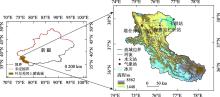
Fig. 1
The map of the headwater catchment of upper Yarkant River"

Tab. 1
The definition for different types of precipitation events"
| 命中事件(H) | 漏报事件(M) | |
| 误报事件(F) | 未降雨事件(N) |

Fig. 2
The spatial distribution of mean annual and seasonal precipitation for different precipitation products"

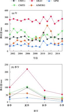
Fig. 3
The average precipitation for multiple precipitation products under different time scales"

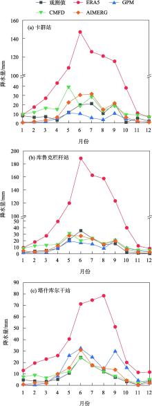
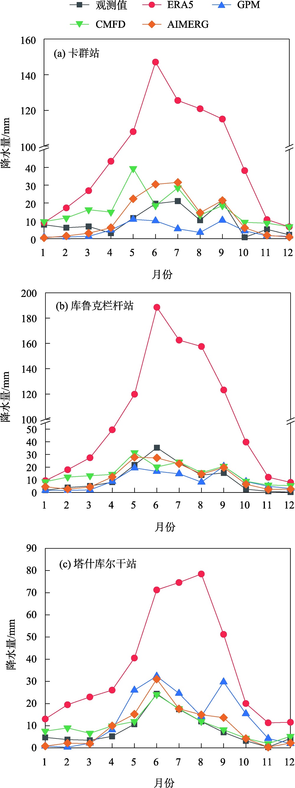
Fig. 4
The seasonal pattern of four precipitation products and observed precipitation from 2001 to 2010"
Tab. 2
Error indexes between precipitation products and observed monthly precipitation"
| 站点 | 数据集 | CC | BIAS/% | RMSE/mm |
|---|---|---|---|---|
| 卡群站 | ERA5 | 0.60 | 565.62 | 74.59 |
| GPM | 0.55 | -51.89 | 12.96 | |
| CMFD | 0.57 | 68.85 | 17.86 | |
| AIMERG | 0.75 | 22.54 | 11.57 | |
| 库鲁克栏杆站 | ERA5 | 0.83 | 593.57 | 88.39 |
| GPM | 0.65 | -16.84 | 9.90 | |
| CMFD | 0.51 | 36.09 | 14.06 | |
| AIMERG | 0.68 | 10.37 | 11.10 | |
| 塔什库尔干站 | ERA5 | 0.64 | 355.85 | 36.40 |
| GPM | 0.45 | 65.75 | 14.98 | |
| CMFD | 0.96 | 22.67 | 3.88 | |
| AIMERG | 0.85 | 15.09 | 8.45 |

Fig. 5
The simulated probability of detection, false alarm ratio and critical success index for four precipitation products at different stations"


Fig. 6
Spatial distribution of correlation coefficients for monthly precipitation from different precipitation products"

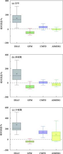
Fig. 7
The box plots of relative error in annual average precipitation"


Fig. 8
Distribution characteristics of total and partial errors of multi-source precipitation products in different seasons"

Tab. 3
Typical cases of applicability evaluation of different precipitation products in the alpine and endorheic river watersheds"
| 序号 | 涉及的降水产品 | 研究区 | 文献来源 |
|---|---|---|---|
| 1 | TRMM3B42、GPM-IMERG、MSWEP V2.2 | 天山地区 | [ |
| 2 | GPM、IMERG-V06、TRMM | 天山地区 | [ |
| 3 | GPM、TRMM、CMORPH | 天山地区 | [ |
| 4 | GPM、TRMM、CMORPH | 天山山区 | [ |
| 5 | GPM、TRMM | 黑河流域 | [ |
| 6 | TRMM 3B42、CMORPH-RAW、CMORPH-CRT、APHRO、CN05.1、ITPCAS | 黑河流域 | [ |
| 7 | IMERG、APHRODITE、CMPA | 亚洲(含天山子区域) | [ |
| 8 | GPM、ERA5、CHIRPS | 伊犁河上游 | [ |
| 9 | TRMM、GPM、PERSIANN、CHIRPS、ERA5 | 开都河上游 | [ |
| [1] | Konapala G, Mishra A K, Wada Y, et al. Climate change will affect global water availability through compounding changes in seasonal precipitation and evaporation[J]. Nature Communications, 2020, 11(1): 1-10. |
| [2] |
郭玉琳, 赵勇, 周雅蔓, 等. 新疆天山山区夏季降水日变化特征及其与海拔高度关系[J]. 干旱区地理, 2022, 45(1): 57-65.
doi: 10.12118/j.issn.1000–6060.2021.057 |
|
[Guo Yulin, Zhao Yong, Zhou Yaman, et al. Diurnal variation of summer precipitation and its relationship with altitude in Tianshan Mountains of Xinjiang[J]. Arid Land Geography, 2022, 45(1): 57-65. ]
doi: 10.12118/j.issn.1000–6060.2021.057 |
|
| [3] | 申豪勇, 李佳, 王志恒, 等. 黄河支流汾河流域水资源开发利用现状及生态环境问题[J]. 中国地质, 2022, 49(4): 1127-1138. |
| [Shen Haoyong, Li Jia, Wang Zhiheng, et al. Water resources utilization and eco-environment problem of Fenhe River, branch of Yellow River[J]. Geology in China, 2022, 49(4): 1127-1138. ] | |
| [4] | 罗映雪, 徐长春, 楚智, 等. CN05. 1气象数据在流域水文模拟中的应用——以新疆开都河流域为例[J]. 气候变化研究进展, 2020, 16(3): 287-295. |
| [Luo Yingxue, Xu Changchun, Chu Zhi, et al. Application of CN05. 1 meteorological data in watershed hydrological simulation: A case study in the upper reaches of Kaidu River Basin[J]. Climate Change Research, 2020, 16(3): 287-295. ] | |
| [5] | 麦杞莹, 谭学志, 吴欣欣, 等. 多个高时空分辨率降水产品在珠江三角洲地区的多尺度精度评估[J]. 中山大学学报(自然科学版)(中英文), 2024, 63(3): 21-31. |
| [Mai Qiying, Tan Xuezhi, Wu Xinxin, et al. Multi-scale accuracy assessment of multiple high spatial and temporal resolution precipitation products in the Pearl River Delta region[J]. Acta Scientiarum Naturalium Universitatis Sunyatseni, 2024, 63(3): 21-31. ] | |
| [6] | Sun H, Su F, Yao T, et al. General overestimation of ERA5 precipitation in flow simulations for high mountain Asia basins[J]. Environmental Research Communications, 2021, 3(12): 1-9. |
| [7] | 汪梓彤, 李石宝, 张志友, 等. GPM近实时降水产品在青藏高原的多尺度精度评价[J]. 人民黄河, 2021, 43(4): 43-49. |
| [Wang Zitong, Li Shibao, Zhang Zhiyou. Multi-scale accuracy evaluation of GPM precipitation products over the Qinghai-Tibet Plateau[J]. Yellow River, 2021, 43(4): 43-49. ] | |
| [8] |
金晓龙, 邵华, 张弛, 等. GPM卫星降水数据在天山山区的适用性分析[J]. 自然资源学报, 2016, 31(12): 2074-2085.
doi: 10.11849/zrzyxb.20160057 |
|
[Jin Xiaolong, Shao Hua, Zhang Chi, et al. The applicability evaluation of three satellite products in Tianshan Mountains[J]. Journal of Natural Resources, 2016, 31(12): 2074-2085. ]
doi: 10.11849/zrzyxb.20160057 |
|
| [9] | Tang G Q, Clark M P, Papalexiou S M, et al. Have satellite precipitation products improved over last two decades? A comprehensive comparison of GPM IMERG with nine satellite and reanalysis datasets[J]. Remote Sensing of Environment, 2020, 240(12): 111697. |
| [10] | Ma Z Q, Xu J T, Zhu S Y, et al. AIMERG: A new Asian precipitation dataset(0.1°/half-hourly, 2000-2015) by calibrating GPM IMERG at daily scale using Aphrodite[J]. Earth System Science Data, 2020, 12(3): 1525-1544. |
| [11] | 陈家琳, 雍斌. GPM-GSMaP卫星降水在中国大陆的误差解析[J]. 亚热带资源与环境学报, 2020, 15(4): 76-85. |
| [Chen Jialin, Yong Bin. Error analysis of global satellite mapping of precipitation for GPM-GSMaP in Mainland China[J]. Journal of Subtropical Resources and Environment, 2020, 15(4): 76-85. ] | |
| [12] | 张茹, 雍斌, 曾岁康, 等. GPM卫星降水产品在中国大陆的精度评估[J]. 人民长江, 2021, 52(5): 50-59. |
| [Zhang Ru, Yong Bin, Zeng Suikang. Evaluation of GPM satellite precipitation products over Mainland China[J]. Yangtze River, 2021, 52(5): 50-59. ] | |
| [13] |
陈昱凝, 胡林金, 颜伟, 等. 叶尔羌河上游不同流域夏季气候和径流变化研究[J]. 冰川冻土, 2014, 36(3): 678-684.
doi: 10.7522/j.issn.1000-0240.2014.0081 |
|
[Chen Yuning, Hu Linjin, Yan Wei, et al. Study of the changes in summer climate and runoff in two upper streams of the Yarkant River[J]. Journal of Glaciology and Geocryology, 2014, 36(3): 678-684. ]
doi: 10.7522/j.issn.1000-0240.2014.0081 |
|
| [14] |
阚宝云, 苏凤阁, 童凯, 等. 四套降水资料在喀喇昆仑山叶尔羌河上游流域的适用性分析[J]. 冰川冻土, 2013, 35(3): 710-722.
doi: 10.7522/j.issn.1000-0240.2013.0081 |
|
[Kan Baoyun, Su Fengge, Tong Kai, et al. Analysis of the applicability of four precipitation datasets in the upper reaches of the Yarkant River, the Karakorum[J]. Journal of Glaciology and Geocryology, 2013, 35(3): 710-722. ]
doi: 10.7522/j.issn.1000-0240.2013.0081 |
|
| [15] | 吴佳, 高学杰. 一套格点化的中国区域逐日观测资料及与其它资料的对比[J]. 地球物理学报, 2013, 56(4): 1102-1111. |
| [Wu Jia, Gao Xuejie. A gridded daily observation dataset over China region and comparison with the other datasets[J]. Chinese Journal of Geophysics, 2013, 56(4): 1102-1111. ] | |
| [16] | Liu Z, Di Z, Qin P, et al. Evaluation of six satellite precipitation products over the Chinese mainland[J]. Remote Sensing, 2022, 14(24): 6277. |
| [17] | 胡一阳, 徐影, 李金建, 等. CMIP6不同分辨率全球气候模式对中国降水模拟能力评估[J]. 气候变化研究进展, 2021, 17(6): 730-743. |
| [Hu Yiyang, Xu Ying, Li Jinjian, et al. Evaluation on the performance of CMIP6 global climate models with different horizontal resolution in simulating the precipitation over China[J]. Climate Change Research, 2021, 17(6): 730-743. ] | |
| [18] | Kan B, Su F, Xu B, et al. Generation of high mountain precipitation and temperature data for a quantitative assessment of flow regime in the upper Yarkant Basin in the Karakoram[J]. Journal of Geophysical Research: Atmospheres, 2018, 123(16): 8462-8486. |
| [19] |
杜懿, 林泽群, 庄胜杰, 等. GPM卫星降水产品在长江流域的空间降尺度研究[J]. 遥感技术与应用, 2023, 38(3): 697-707.
doi: 10.11873/j.issn.1004-0323.2023.3.0697 |
| [Du Yi, Lin Zequn, Zhuang Shengjie, et al. Spatial downscaling of GPM satellite precipitation products in the Yangtze River Basin, China[J]. Remote Sensing Technology and Application, 2023, 38(3): 697-707. ] | |
| [20] | 林书睿, 顾恒竹, 路明月, 等. 基于GWR模型的典型区域GPM数据降尺度研究——以浙江省为例[J]. 气象科学, 2022, 42(6): 793-803. |
| [Lin Shurui, Gu Hengzhu, Lu Mingyue. Downscaling research of GPM data in typical region based on GWR model: A case study of Zhejiang Province[J]. Journal of the Meteorological Sciences, 2022, 42(6): 793-803. ] | |
| [21] |
刘婷婷, 朱秀芳, 郭锐, 等. ERA5再分析降水数据在中国的适用性分析[J]. 干旱区地理, 2022, 45(1): 66-79.
doi: 10.12118/j.issn.1000–6060.2021.132 |
|
[Liu Tingting, Zhu Xiufang, Guo Rui, et al. Applicability of ERA5 reanalysis of precipitation data in China[J]. Arid Land Geography, 2022, 45(1): 66-79. ]
doi: 10.12118/j.issn.1000–6060.2021.132 |
|
| [22] | 刘鸿波, 董理, 严若婧, 等. ERA5再分析资料对中国大陆区域近地层风速气候特征及变化趋势再现能力的评估[J]. 气候与环境研究, 2021, 26(3): 299-311. |
| [Liu Hongbo, Dong Li, Yan Ruojing, et al. Evaluation of Near-surface wind speed climatology and long-term trend over China’s Mainland Region based on ERA5 reanalysis[J]. Climate and Environmental Research, 2021, 26(3): 299-311. ] | |
| [23] | 夏怡洁. 基于CMFD数据的新疆天山降水同位素云下二次蒸发研究[D]. 兰州: 西北师范大学, 2023. |
| [Xia Yijie. Below-cloud Secondary Evaporation of Precipitation Isotopes across the Tianshan Mountains in Xinjiang Based on the CMFD Data[D]. Lanzhou: Northwest Normal University, 2023. ] | |
| [24] | 崔豪, 王贺佳, 肖伟华, 等. 三峡库区CMFD降水数据适用性评估[J]. 人民长江, 2021, 52(8): 98-104. |
| [Cui Hao, Wang Hejia, Xiao Weihua, et al. Evaluation on application accuracy of CMFD precipitation data in Three Gorges Reservoir Area[J]. Yangtze River, 2021, 52(8): 98-104. ] | |
| [25] | Tian Y, Peters-Lidard C D, Eylander J B, et al. Component analysis of errors in satellite-based precipitation estimates[J]. Journal of Geophysical Reserch-atmospheres, 2009, 114(D24): 1-15. |
| [26] | Li X, He X, Li X, et al. Spatiotemporal evaluation and estimation of precipitation of multi-source precipitation products in Arid Areas of Northwest China—A Case Study of Tianshan Mountains[J]. Water, 2022, 14(16): 2566. |
| [27] | Anjum N M, Ahmad I, Ding Y, et al. Assessment of IMERG-V06 precipitation product over different hydro-climatic regimes in the Tianshan Mountains, North-Western China[J]. Remote Sensing, 2019, 11(19): 2314-2314. |
| [28] | Chi Z, Xi C, Hua S, et al. Evaluation and intercomparison of high-resolution satellite precipitation estimates—GPM, TRMM, and CMORPH in the Tianshan Mountain area[J]. Remote Sensing, 2018, 10: 1543. |
| [29] |
王思梦, 王大钊, 黄昌. GPM卫星降水数据在黑河流域的适用性评价[J]. 自然资源学报, 2018, 33(10): 1847-1860.
doi: 10.31497/zrzyxb.20171180 |
|
[Wang Simeng, Wang Dazhao, Huang Chang. Evaluating the applicability of GPM satellite precipitation data in Heihe River Basin[J]. Journal of Natural Resources, 2018, 33(10): 1847-1860. ]
doi: 10.31497/zrzyxb.20171180 |
|
| [30] | Yang Y, Tang J, Xiong Z, et al. Evaluation of high-resolution gridded precipitation data in arid and semiarid regions: Heihe River Basin, Northwest China[J]. Journal of Hydrometeorology, 2017, 18(12): 3075-3101. |
| [31] |
尹瑞琪, 李琼芳, 陈启慧, 等. 伊犁河上游流域三种日尺度降水产品性能评估[J]. 干旱区研究, 2024, 41(4): 540-549.
doi: 10.13866/j.azr.2024.04.02 |
|
[Yin Ruiqi, Li Qiongfang, Chen Qihui, et al. Performance evaluation of three daily precipitation products in the upper reaches of the Ili River[J]. Arid Zone Research, 2024, 41(4): 540-549. ]
doi: 10.13866/j.azr.2024.04.02 |
|
| [32] | 陈世雪. 多源降水数据的开都河上游水文模拟效用评估[D]. 乌鲁木齐: 新疆师范大学, 2022. |
| [Chen Shixue. Assessment of the Utility of Hydrological Simulation of Theupper Kaidu River with Multi-source Precipitation Date[D]. Urumqi: Xinjiang Normal University, 2022. ] | |
| [33] | 赵彤, 赵梦凡, 周秉荣, 等. 三种再分析气温降水资料在青藏高原的适用性评价[J]. 沙漠与绿洲气象, 2023, 17(3): 116-125. |
| [Zhao Tong, Zhao Mengfan, Zhou Bingrong, et al. Applicability evaluation for three reanalysis datasets of temperature and precipitation over the Tibetan Plateau[J]. Desert and Oasis Meteorology, 2023, 17(3): 116-125. ] | |
| [34] | 班春广, 左德鹏, 徐宗学, 等. 高寒区多源降水产品精度与水文模拟效果评估——以雅鲁藏布江流域和拉萨河流域为例[J]. 水土保持学报, 2023, 37(2): 159-168. |
| [Ban Chunguang, Zuo Depeng, Xu Zongxue, et al. Assessment on the accuracy and hydrological simulation effect of multi-source precipitation products in the high cold alpine region——Case study in the Yarlung Zangbo River Basin and the Lhasa River Basin[J]. Journal of Soil and Water Conservation, 2023, 37(2): 159-168. ] |
| [1] | LUO Chengyan,CHEN Fulong,HE Chaofei,LONG Aihua,QIAO Changlu. Applicability of CMADS in runoff simulation of Yulong Kashi River [J]. Arid Zone Research, 2022, 39(4): 1090-1101. |
| [2] | SONG Haiqing,ZHU Zhongyuan,LI Yunpeng. Validation of land data assimilation and reanalysis precipitation datasets over Inner Mongolia [J]. Arid Zone Research, 2021, 38(6): 1624-1636. |
|
||