Arid Zone Research ›› 2023, Vol. 40 ›› Issue (2): 203-212.doi: 10.13866/j.azr.2023.02.05
• Land and Water Resources • Previous Articles Next Articles
ZHANG Enyue1( ),ZHENG Junyan2,SU Yingqing3,ZHANG Lei4,ZHANG Pengfei1,LIU Geng1()
Received:2022-07-11
Revised:2022-11-21
Online:2023-02-15
Published:2023-03-08
ZHANG Enyue, ZHENG Junyan, SU Yingqing, ZHANG Lei, ZHANG Pengfei, LIU Geng. Optimization of low-carbon land use pattern based on scenario simulation: A case study of Fenhe River Basin[J].Arid Zone Research, 2023, 40(2): 203-212.
Add to citation manager EndNote|Reference Manager|ProCite|BibTeX|RefWorks
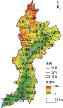
Fig. 1
Location of Fenhe River Basin"

Tab. 1
Data type and source"
| 数据类型 | 指标 | 数据来源 |
|---|---|---|
| 基础数据 | 山西省行政边界 | 中国科学院资源环境科学数据中心( |
| 阻力因子 | 土地利用/覆被 | 中国科学院资源环境科学数据中心( (Landsat 8 30 m) |
| 高程/m | 中国科学院资源环境科学数据中心( 2000年山西省DEM(SRTM 30 m) | |
| 坡度/(°) | ||
| 土壤厚度/cm | 国家地球系统科学数据中心—土壤分中心( 中国高分辨率国家土壤信息格网基本属性数据集(2010—2018)1 km | |
| 植被覆盖度/% | 地理空间数据云(www.gscloud.cn) MOD13Q1数据集2020年 250 m | |
| 年均气温/℃ | WorldClim version 2.0( | |
| 年均降水量/mm | ||
| 距道路距离/m | 国家基础地理信息中心(www.ngcc.cn/ngcc/) 2015年1:1000000中国基础地理信息数据 | |
| 距水体距离/m |
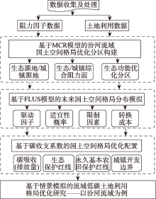
Fig. 2
Study framework"
Tab. 2
Situation types and conversion principles"
| 情景类型 | 转换原则 |
|---|---|
| 低碳发展优先 | 结合《中国能源统计年鉴》、中国碳核算数据库( |
| 生态保护优先 | 基于《汾河流域生态修复规划(2015—2030年)》、《汾河流域生态景观规划(2020—2035)》等相关省市国土空间规划基础,纳入生态保护红线区域限制转换,按用地类型生态效益等级依次转换林地、水域、草地、其他 |
| 耕地保护优先 | 通过加入永久基本农田保护区为限制转化区,控制耕地向建设用地转移,除建设用地,加大其他用地类型转换为耕地的概率 |
| 自然发展 | 以2015—2020年土地利用变化速率及基准年驱动因子为源,不考虑政策规划限制,预测各地类未来规模 |
| 经济发展优先 | 基于《山西省国民经济和社会发展第十四个五年规划和2035年远景目标纲要》及历年建设用地等变化趋势,以最大增长量为目标,按低到高等级用地单向转换原则排序:建设用地、耕地、林地、草地、水域等,优先安排建设用地转换 |

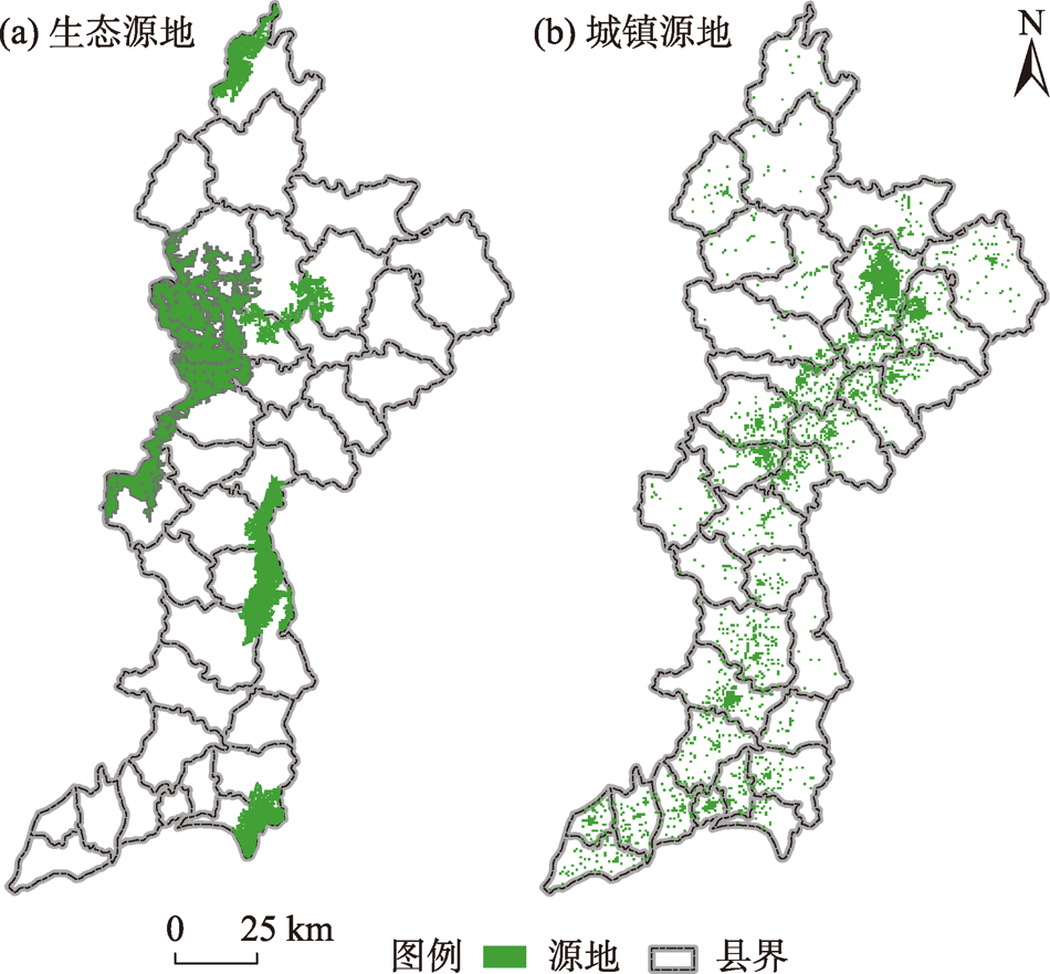
Fig. 3
Ecological source and town source in Fenhe River Basin"
Tab. 3
Classification and weight of ecological/urban source resistance factors"
| 阻力因子 | 阻力因子分级(生态/城镇源地) | 权重 | ||||
|---|---|---|---|---|---|---|
| 低阻力/ 高阻力 | 较低阻力/ 较高阻力 | 中等阻力/ 中等阻力 | 较高阻力/ 较低阻力 | 高阻力/ 低阻力 | ||
| 高程/m | >1600 | 1200~1600 | 1000~1200 | 800~1000 | <800 | 0.1412 |
| 坡度/(°) | >60 | 45~60 | 30~45 | 13~30 | <13 | 0.1313 |
| 土地利用类型 | 林地、水域 | 草地 | 耕地 | 未利用地 | 建设用地 | 0.1540 |
| 土壤厚度/cm | >150 | 100~150 | 60~100 | 40~60 | <40 | 0.0783 |
| 植被覆盖度/% | >80 | 60~80 | 40~60 | 20~40 | 0~20 | 0.1358 |
| 年均气温/℃ | <4 | 4~7 | 7~9 | 9~11 | >11 | 0.0632 |
| 年均降水量/mm | >548 | 515~548 | 483~515 | 447~483 | 0~447 | 0.0674 |
| 距道路距离/m | >138 | 88~138 | 51~88 | 17~51 | 0~17 | 0.1072 |
| 距水体距离/m | 0~54 | 54~114 | 114~182 | 182~284 | >284 | 0.1216 |
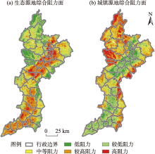
Fig. 4
Ecological/urban comprehensive resistance area"


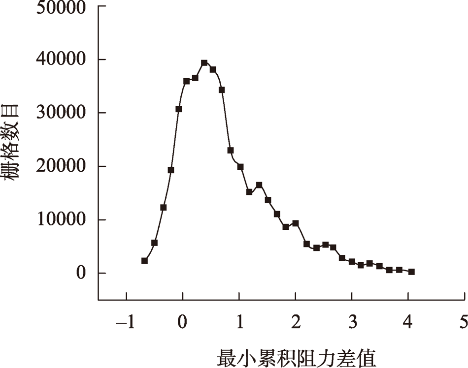
Fig. 5
Relationship of grid numbers and minimal accumulated margin"
Tab. 4
Carbon budget coefficient table of land use types /(t·hm-2·a-1)"
| 用地类型 | 碳收支系数 | 碳效应 |
|---|---|---|
| 耕地 | 0.37 | 碳源 |
| 林地 | -0.49 | 碳汇 |
| 草地 | -0.02 | 碳汇 |
| 水域 | -0.46 | 碳汇 |
| 建设用地 | 65.30 | 碳源 |
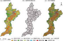
Fig. 6
Land use pattern and functional zoning in Fenhe River Basin"

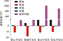
Fig. 7
Carbon balance of land use types in Fenhe River Basin in 2020"
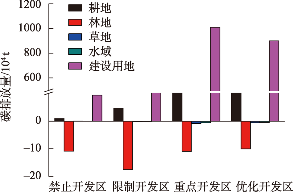

Fig. 8
Multi-scenario land use optimization zoning of Fenhe River Basin in 2030"

| [1] | 邓旭, 谢俊, 滕飞. 何谓“碳中和”?[J]. 气候变化研究进展, 2021, 17(1): 107-113. |
| [Deng Xu, Xie Jun, Teng Fei. What is carbon neutrality?[J]. Climate Change Research, 2021, 17(1): 107-113.] | |
| [2] | 项目综合报告编写组. 《中国长期低碳发展战略与转型路径研究》综合报告[J]. 中国人口·资源与环境, 2020, 30(11): 1-25. |
| [The project comprehensive report compilation group. ‘Research on China’s long-term low-carbon development strategy and transformation path’ comprehensive report[J]. China Population, Resources and Environment, 2020, 30(11): 1-25.] | |
| [3] | 王灿, 张雅欣. 碳中和愿景的实现路径与政策体系[J]. 中国环境管理, 2020, 12(6): 58-64. |
| [Wang Can, Zhang Yaxin. Implementation pathway and policy system of carbon neutrality vision[J]. Chinese Journal of Environmental Management, 2020, 12(6): 58-64.] | |
| [4] | 周宏春, 史作廷. 双碳导向下的绿色消费: 内涵、传导机制和对策建议[J]. 中国科学院院刊, 2022, 37(2): 188-196. |
| [Zhou Hongchun, Shi Zuoting. Green consumption under carbon-orientated: Connotation, transmission mechanism and countermeasures[J]. Bulletin of Chinese Academy of Sciences, 2022, 37(2): 188-196.] | |
| [5] | 余碧莹, 赵光普, 安润颖, 等. 碳中和目标下中国碳排放路径研究[J]. 北京理工大学学报(社会科学版), 2021, 23(2): 17-24. |
| [Yu Biying, Zhao Guangpu, An Runying, et al. Research on China’s CO2 emission pathway under carbon neutral target[J]. Journal of Beijing Institute of Technology(Social Sciences Edition), 2021, 23(2): 17-24.] | |
| [6] | 杨皓然, 吴群. 不同政策方案下的南京市土地利用碳排放动态模拟[J]. 地域研究与开发, 2021, 40(3): 121-126. |
| [Yang Haoran, Wu Qun. Dynamic simulation of carbon emissions from land use in Nanjing City under different policy scenarios[J]. Areal Research and Development, 2021, 40(3): 121-126.] | |
| [7] |
赵宏波, 魏甲晨, 孙东琪, 等. 基于随机森林模型的“生产-生活-生态”空间识别及时空演变分析——以郑州市为例[J]. 地理研究, 2021, 40(4): 945-957.
doi: 10.11821/dlyj020200237 |
|
[Zhao Hongbo, Wei Jiachen, Sun Dongqi, et al. Recognition and spatio-temporal evolution analysis of production-living-ecological spaces based on the random forest model: A case study of Zhengzhou City, China[J]. Geographical Research, 2021, 40(4): 945-957.]
doi: 10.11821/dlyj020200237 |
|
| [8] |
陈万旭, 李江风, 曾杰, 等. 中国土地利用变化生态环境效应的空间分异性与形成机理[J]. 地理研究, 2019, 38(9): 2173-2187.
doi: 10.11821/dlyj020180659 |
|
[Chen Wanxu, Li Jiangfeng, Zeng Jie, et al. Spatial heterogeneity and formation mechanism of eco-environmental effect of land use change in China[J]. Geographical Research, 2019, 38(9): 2173-2187.]
doi: 10.11821/dlyj020180659 |
|
| [9] | 袁利, 刘毅华, 邱坚坚. 经济与生态效益不同情景下的广州市土地利用优化配置[J]. 生态经济, 2021, 37(4): 103-109. |
| [Yuan Li, Liu Yihua, Qiu Jianjian. An optimal allocation analysis of land use under different scenarios with economic and ecological benefits in Guangzhou[J]. Ecological Economy, 2021, 37(4): 103-109.] | |
| [10] | 涂小松, 濮励杰, 严祥, 等. 土地资源优化配置与土壤质量调控的系统动力学分析[J]. 环境科学研究, 2009, 22(2): 221-226. |
| [Tu Xiaosong, Pu Lijie, Yan Xiang, et al. Analysis of optimal allocation of land resources and soil quality regulation using system dynamics[J]. Research of Environmental Sciences, 2009, 22(2): 221-226.] | |
| [11] | 魏伟, 颉耀文, 魏晓旭, 等. 基于CLUE-S模型和生态安全格局的石羊河流域土地利用优化配置[J]. 武汉大学学报(信息科学版), 2017, 42(9): 1306-1315. |
| [Wei Wei, Xie Yaowen, Wei Xiaoxu, et al. Land use optimization based on CLUE-S model and ecology security scenario in Shiyang River Basin[J]. Geomatics and Information Science of Wuhan University, 2017, 42(9): 1306-1315.] | |
| [12] | 王帝文, 李飞雪, 陈东. 基于Pareto最优和多目标粒子群的土地利用优化配置研究[J]. 长江流域资源与环境, 2019, 28(9): 2019-2029. |
| [Wang Diwen, Li Feixue, Chen Dong. Research on optimal land use allocation based on pareto optimal and multi-particle swarm algorithm[J]. Resources and Environment in the Yangtze Basin, 2019, 28(9): 2019-2029.] | |
| [13] | 彭玉玲, 徐学娴, 隗剑秋, 等. 老挝凯山丰威汉市土地资源的空间优化配置[J]. 水土保持通报, 2021, 41(5): 160-165, 373. |
| [Peng Yuling, Xu Xuexian, Yu Jianqiu, et al. Spatial optimal allocation of land resources in Fengweihan City, Kaishan, Laos[J]. Bulletin of Soil and Water Conservation, 2021, 41(5): 160-165, 373.] | |
| [14] | 管成文. 基于CLUE-S模型和生态敏感性分析的江川区土地利用空间格局优化配置[D]. 昆明: 云南大学, 2018. |
| [Guan Chengwen. Optimal Allocation of Land Use Spatial Pattern in Jiangchuan Area Based on CLUE-S Model and Ecological Sensitivity Analysis[D]. Kunming: Yunnan University, 2018.] | |
| [15] |
马冰滢, 黄姣, 李双成. 基于生态-经济权衡的京津冀城市群土地利用优化配置[J]. 地理科学进展, 2019, 38(1): 26-37.
doi: 10.18306/dlkxjz.2019.01.003 |
|
[Ma Bingying, Huang Jiao, Li Shuangcheng. Optimal allocation of land use types in the Beijing-Tianjin-Hebei urban agglomeration based on ecological and economic benefits trade-offs[J]. Progress in Geography, 2019, 38(1): 26-37.]
doi: 10.18306/dlkxjz.2019.01.003 |
|
| [16] |
陈红, 史云扬, 柯新利, 等. 生态与经济协调目标下的郑州市土地利用空间优化配置[J]. 资源科学, 2019, 41(4): 717-728.
doi: 10.18402/resci.2019.04.09 |
|
[Chen Hong, Shi Yunyang, Ke Xinli, et al. Spatial optimization of land use based on the objective of coordinated ecological protection and economic development in Zhengzhou City[J]. Resources Science, 2019, 41(4): 717-728.]
doi: 10.18402/resci.2019.04.09 |
|
| [17] | 魏伟, 石培基, 周俊菊, 等. 基于生态安全格局的干旱内陆河流域土地利用优化配置分区[J]. 农业工程学报, 2016, 32(18): 9-18. |
| [Wei Wei, Shi Peiji, Zhou Junju, et al. Configuration partition of land use optimization in arid inland river basin based on ecological security pattern[J]. Transactions of the Chinese Society of Agricultural Engineering, 2016, 32(18): 9-18.] | |
| [18] |
Zhang X J, Wang G Q, Xue B L, et al. Dynamic landscapes and the driving forces in the Yellow River Delta wetland region in the past four decades[J]. Science of the Total Environment, 2021, 787: DOI: 10.1016/j.scitotenv.2021.147644.
doi: 10.1016/j.scitotenv.2021.147644 |
| [19] | Liu X P, Liang X, Li X, et al. A future land use simulation model (FLUS) for simulating multiple land use scenarios by coupling human and natural effects[J]. Landscape & Urban Planning, 2017, 168: 94-116. |
| [20] | 齐麟, 许东, 朱琪, 等. 基于GeoSOS-FLUS平台的东北森林屏障带生态格局优化[J]. 生态学杂志, 2021, 40(11): 3448-3462. |
| [Qi Lin, Xu Dong, Zhu Qi, et al. Ecological pattern optimization of forest barrier belt in Northeast China based on GeoSOS-FLUS[J]. Chinese Journal of Ecology, 2021, 40(11): 3448-3462.] | |
| [21] | 苏迎庆, 刘庚, 赵景波, 等. 基于FLUS模型的汾河流域生态空间多情景模拟预测[J]. 干旱区研究, 2021, 38(4): 1152-1161. |
| [Su Yingqing, Liu Geng, Zhao Jingbo, et al. Multi-scenario simulation prediction of ecological space in Fenhe River Basin based on FLUS model[J]. Arid Zone Research, 2021, 38(4): 1152-1161.] | |
| [22] | 景艳宾, 孙旭, 刘军, 等. 基于MCR模型的内蒙古鄂托克旗生态廊道构建[J]. 水土保持通报, 2021, 41(2): 170-177. |
| [Jing Yanbin, Sun Xu, Liu Jun, et al. Construction of ecological corridorin Etuoke Banner of Inner Mongolian based on MCR model[J]. Bulletin of Soil and Water Conservation, 2021, 41(2): 170-177.] | |
| [23] | 刘海龙, 王炜桥, 王跃飞, 等. 汾河流域生态敏感性综合评价及时空演变特征[J]. 生态学报, 2021, 41(10): 3952-3964. |
| [Liu Hailong, Wang Weiqiao, Wang Yuefei, et al. Comprehensive evaluation of the ecological sensitivity and the characteristics of temporal and spatial variations in Fenhe River Basin[J]. Acta Ecologica Sinica, 2021, 41(10): 3952-3964.] | |
| [24] |
陈南南, 康帅直, 赵永华, 等. 基于MSPA和MCR模型的秦岭(陕西段)山地生态网络构建[J]. 应用生态学报, 2021, 32(5): 1545-1553.
doi: 10.13287/j.1001-9332.202105.012 |
|
[Chen Nannan, Kang Shuaizhi, Zhao Yonghua, et al. Construction of ecological network in Qinling Mountains of Shaanxi, China based on MSPA and MCR model[J]. Chinese Journal of Applied Ecology, 2021, 32(5): 1545-1553.]
doi: 10.13287/j.1001-9332.202105.012 |
|
| [25] | 钟式玉, 吴箐, 李宇, 等. 基于最小累积阻力模型的城镇土地空间重构——以广州市新塘镇为例[J]. 应用生态学报, 2012, 23(11): 3173-3179. |
| [Wu Qing, Li Yu, et al. Reconstruction of urban land space based on minimum cumulative resistance model: A case study of Xintang Town, Guangzhou City[J]. Chinese Journal of Applied Ecology, 2012, 23(11): 3173-3179.] | |
| [26] | 林伊琳, 赵俊三, 陈国平, 等. 基于MCR-FLUS-Markov模型的区域国土空间格局优化[J]. 农业机械学报, 2021, 52(4): 159-170, 207. |
| [Lin Yilin, Zhao Junsan, Chen Guoping, et al. Optimization of regional territory space pattern based on MCR-FLUS-Markov model[J]. Transactions of the Chinese Society for Agricultural Machinery, 2021, 52(4): 159-170, 207.] | |
| [27] |
刘敏, 郝炜. 山西省国家A级旅游景区空间分布影响因素研究[J]. 地理学报, 2020, 75(4): 878-888.
doi: 10.11821/dlxb202004015 |
|
[Liu Min, Hao Wei. Spatial distribution and its influencing factors of national A-level tourist attractions in Shanxi Province[J]. Acta Geographica Sinica, 2020, 75(4): 878-888.]
doi: 10.11821/dlxb202004015 |
|
| [28] | 郑洋, 郝润梅, 吴晓光, 等. 基于MCR模型的村庄“三生空间”格局优化研究[J]. 水土保持研究, 2021, 28(5): 362-367. |
| [Zheng Yang, Hao Runmei, Wu Xiaoguang, et al. Research on the space pattern optimization of production-living-ecology spacesin village based on MCR model[J]. Research of Soil and Water Conservation, 2021, 28(5): 362-367.] | |
| [29] | 刘孝富, 舒俭民, 张林波. 最小累积阻力模型在城市土地生态适宜性评价中的应用——以厦门为例[J]. 生态学报, 2010, 30(2): 421-428. |
| [Liu Xiaofu, Shu Jianmin, Zhang Linbo. Research on applying minimal cumulative resistance model in urban land ecological suitability assessment: As an example of Xiamen City[J]. Acta Ecologica Sinica, 2010, 30(2): 421-428.] | |
| [30] | 张杰, 陈海, 刘迪, 等. 基于县域尺度土地利用碳排放的时空分异及影响因素研究[J]. 西北大学学报(自然科学版), 2022, 52(1): 21-31. |
| [Zhang Jie, Chen Hai, Liu Di, et al. The spatial and temporal variation and influencing factors of land use carbon emissions at county scale[J]. Journal of Northwest University(Natural Science Edition), 2022, 52(1): 21-31.] | |
| [31] | 朱向梅, 王子莎. 黄河流域碳水足迹评价及时空格局研究[J]. 环境科学与技术, 2020, 43(10): 200-211. |
| [Zhu Xiangmei, Wang Zisha. Study on the assessment of carbon and water footprint and its spatial-temporal pattern in the Yellow River Basin[J]. Environmental Science & Technology, 2020, 43(10): 200-211.] | |
| [32] |
周嘉, 王钰萱, 刘学荣, 等. 基于土地利用变化的中国省域碳排放时空差异及碳补偿研究[J]. 地理科学, 2019, 39(12): 1955-1961.
doi: 10.13249/j.cnki.sgs.2019.12.014 |
|
[Zhou Jia, Wang Yuxuan, Liu Xuerong, et al. Spatial temporal differences of carbon emissions and carbon compensation in China based on land use change[J]. Scientia Geographica Sinica, 2019, 39(12): 1955-1961.]
doi: 10.13249/j.cnki.sgs.2019.12.014 |
|
| [33] | 禹康康, 王延华, 孙恬, 等. 太湖流域土地利用碳排放变化及其预测[J]. 土壤, 2022, 54(2): 406-414. |
| [Yu Kangkang, Wang Yanhua, Sun Tian, et al. Changes and prediction of carbon emission from different land use types in Taihu Lake Basin[J]. Soils, 2022, 54(2): 406-414.] |
|
||