Arid Zone Research ›› 2022, Vol. 39 ›› Issue (4): 1076-1089.doi: 10.13866/j.azr.2022.04.09
• Water Resources and Utilization • Previous Articles Next Articles
ZHU Cunxiong1,2( ),SHI Feifei1,2,QIAO Bin1,2,ZHANG Juan1,2,CHEN Guoqian1,2()
Received:2021-11-08
Revised:2022-01-23
Online:2022-07-15
Published:2022-09-26
Contact:
Guoqian CHEN
E-mail:zhucunxiong_2008@126.com;guoxi_chen@163.com
ZHU Cunxiong,SHI Feifei,QIAO Bin,ZHANG Juan,CHEN Guoqian. Analysis of Qinghai Lake expansion and lakeside sandy land change characteristics based on GF-1 satellite[J].Arid Zone Research, 2022, 39(4): 1076-1089.
Add to citation manager EndNote|Reference Manager|ProCite|BibTeX|RefWorks
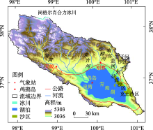
Fig. 1
Map of the geographical location of Qinghai Lake"

Tab. 1
Classfication of fractional vegetation cover degree in sandland"
| 等级代码 | 植被覆盖度 | FVC值 |
|---|---|---|
| I级 | 低覆盖度 | 0≤FVC<5% |
| II级 | 中低覆盖度 | 5%≤FVC<15% |
| III级 | 中覆盖度 | 15%≤FVC<30% |
| IV级 | 中高覆盖度 | 30%≤FVC<60% |
| V级 | 高覆盖度 | FVC>60% |
Fig. 2
Changes of area and shoreline length of Qinghai Lake (a) and Gahai (b) from 2013 to 2020"
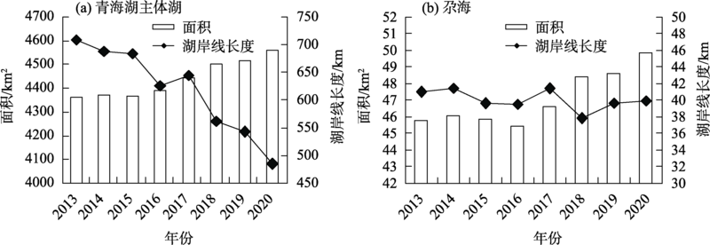
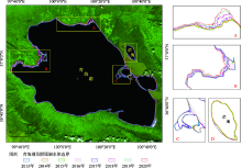
Fig. 3
Remote sensing monitoring map of Qinghai Lake and its affiliated lakes"
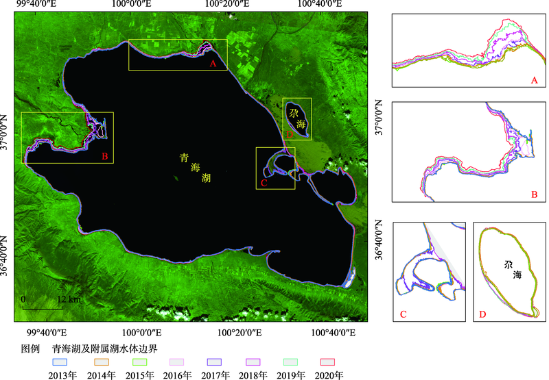
Fig. 4
Change of sand area of Bird Island in Qinghai Lake"


Fig. 5
Interannual variation of Gahai sand area、Ketu sand area and Ganzi River sand area from 2013 to 2020"
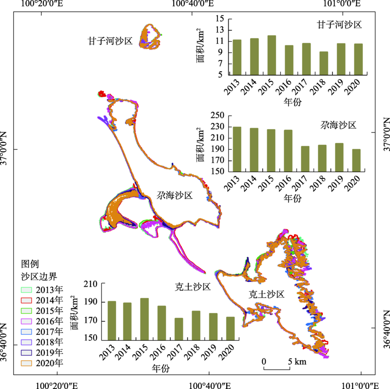

Fig. 6
Temporal and spatial evolution of water-sand area and FVC in Qinghai Lake"
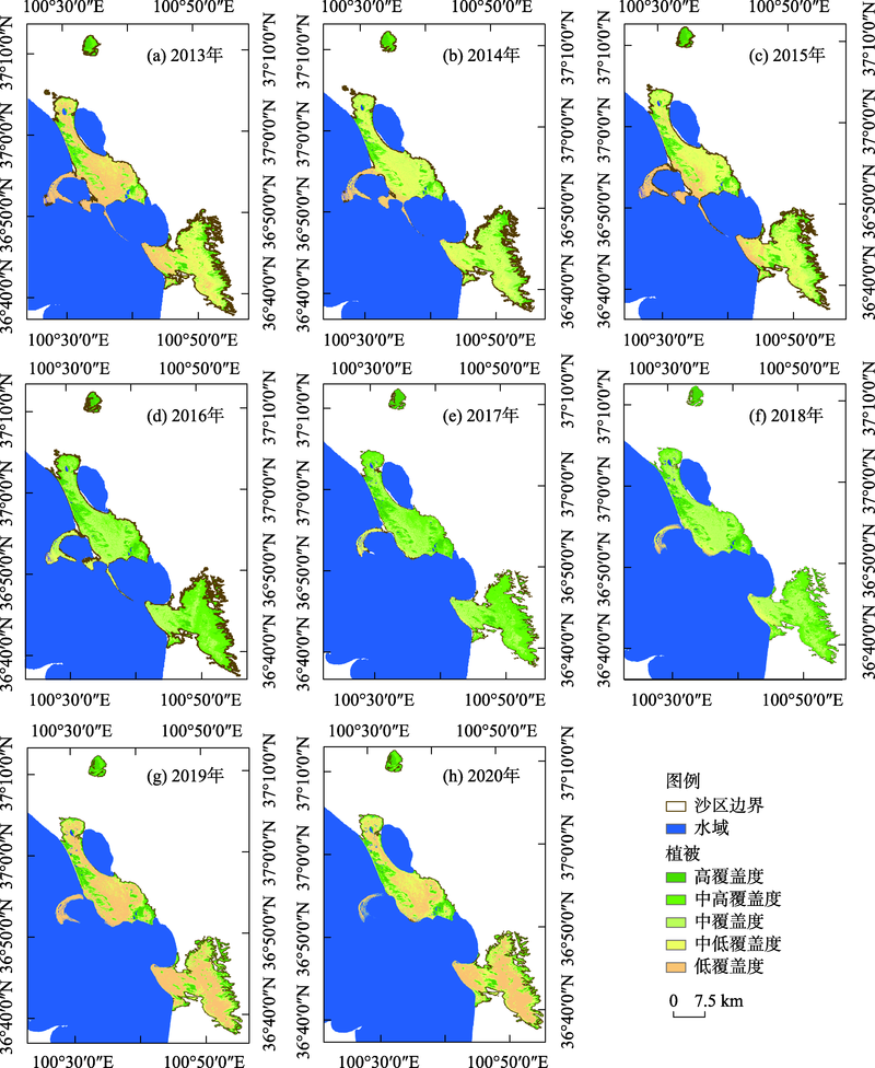
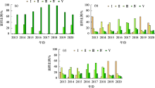
Fig. 7
Interannual variation of vegetation coverage of different grades in the total area of each sandy area"


Fig. 8
Change of annual mean temperature anomaly and annual precipitation anomaly percentage at Gangcha and Tianjun stations since 1981"
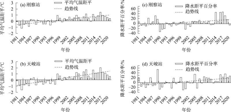

Fig. 9
Changes of accumulative snow cover area in Qinghai Lake Basin during snow season from 2013 to 2020"
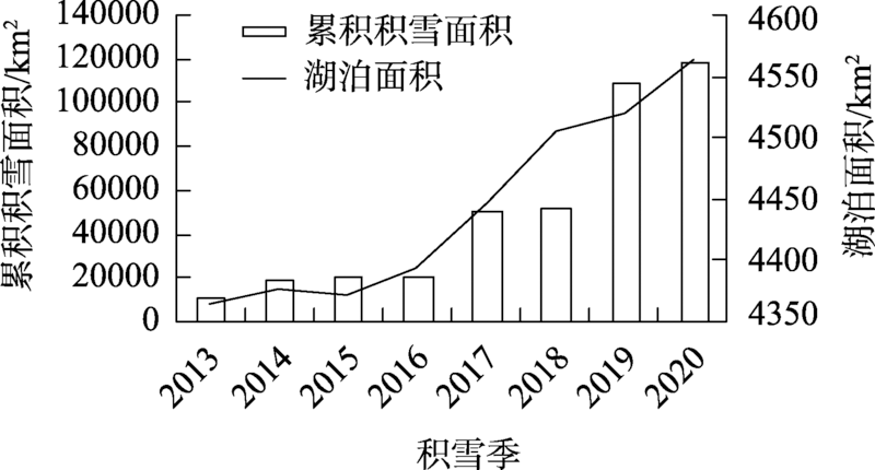
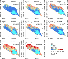
Fig. 10
Change of accumulative days with snow cover in Qinghai Lake Basin during 2013-2020"

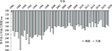
Fig. 11
Maximum annual variation of seasonal frozen soil depth at Gangcha and Tianjun stations in Qinghai Lake Basin since 1986"
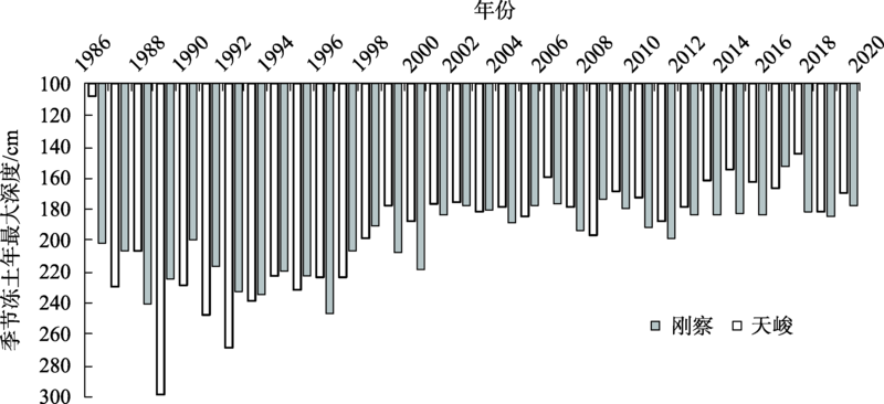
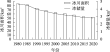
Fig. 12
Variation of glacier area and ice storage in Gangeerxiaoheli"

Tab. 2
Correlation analysis and contribution rate of influencing factors of Qinghai Lake area change"
| 影响因子 | 相关系数 | 相对贡献率/% |
|---|---|---|
| 平均气温 | -0.694 | 5.29 |
| 年降水量 | 0.112 | 4.65 |
| 上一年降水量 | 0.554 | 1.97 |
| 积雪面积 | 0.941** | 23.39 |
| 冻土(天峻) | 0.572 | 31.39 |
| 冻土(刚察) | -0.141 | 33.08 |
Tab. 3
Correlation between the area of Qinghai Lake and its affiliated lakes and the area of sand area"
| 主体湖面积 | 尕海面积 | 甘子河沙区面积 | 尕海沙区面积 | 克土沙区面积 | |
|---|---|---|---|---|---|
| 主体湖面积 | 1 | ||||
| 尕海面积 | 0.970** | 1 | |||
| 甘子河沙区面积 | -0.591 | -0.475 | 1 | ||
| 尕海沙区面积 | -0.924** | -0.854** | 0.581 | 1 | |
| 克土沙区面积 | -0.834* | -0.719* | 0.578 | 0.935** | 1 |
| [1] | 王苏民, 窦鸿身. 中国湖泊志[M]. 北京: 科学出版社, 1998. |
| [Wang Sumin, Du Hongshen. The Journal of Lake in China[M]. Beijing: Science Press, 1998.] | |
| [2] | 施雅风. 气候变化对西北华北水资源的影响[M]. 济南: 山东科学出版社, 1995: 127-141. |
| [Shi Yafeng. Impact of Climate Change on Water Resource in Northwest and North China[M]. Ji’nan: Shangdong Scientific Publish Press, 1995: 127-141.] | |
| [3] | 朱立平, 鞠建廷, 乔宝晋, 等. “亚洲水塔”的近期湖泊变化及气候响应: 进展、问题与展望[J]. 科学通报, 2019, 64(27): 2796-2806. |
| [Zhu Liping, Ju Jianting, Qiao Baojin, et al. Recent lake changes of the Asia Water Tower and their climate response: Progress, problems and prospects[J]. Chinese Science Bulletin, 2019, 64(27): 2796-2806.] | |
| [4] | 王天慈, 卢丽华, 刘国祥, 等. 青海湖湖滨湿地演变与驱动因素分析[J]. 中国水利水电科学研究院学报, 2020, 18(4): 274-283. |
| [Wang Tianci, Lu Lihua, Liu Guoxiang, et al. Analysis of lakeside wetland evolution and driving factors around Qinghai Lake[J]. Journal of China Institute of Water Resources and Hydropower Research, 2020, 18(4): 274-283.] | |
| [5] | 朱立平, 张国庆, 杨瑞敏, 等. 青藏高原最近40年湖泊变化的主要表现与发展趋势[J]. 中国科学院院刊, 2019, 34(11): 1254-1263. |
| [Zhu Liping, Zhang Guoqing, Yang Ruimin, et al. Lake variations on Tibetan Plateau of recent 40 years and future changing tendency[J]. Bulletin of Chinese Academy of Sciences, 2019, 34(11): 1254-1263.] | |
| [6] | 白爱娟, 黄融, 程志刚. 气候变暖情景下的青海湖水位变化[J]. 干旱区研究, 2014, 31(5): 792-797. |
| [Bai Aijuan, Huang Rong, Cheng Zhigang. Change of water level of the Qinghai Lake under climate warming[J]. Arid Zone Research, 2014, 31(5): 792-797.] | |
| [7] | 张国庆, Xie Hongjie, 姚檀栋, 等. 基于ICESat和Landsat的中国十大湖泊水量平衡估算[J]. 科学通报, 2013, 58(26): 2664-2678. |
| [Zhang Guoqing, Xie HongJie, Yao Tandong, et al. Water balance estimates of ten greatest lakes in China using ICESat and Landsat data[J]. Chinese Science Bulletin, 2013, 58(26): 2664-2678.] | |
| [8] | 李林, 申红艳, 刘彩红, 等. 青海湖水位波动对气候暖湿化情景的响应及其机理研究[J]. 气候变化研究进展, 2020, 16(5): 600-608. |
| [Li Lin, Shen Hongyan, Liu Caihong, et al. Response of water level fluctuation to climate warming and wetting scenarios and its mechanism on Qinghai Lake[J]. Climate Change Research, 2020, 16(5): 600-608.] | |
| [9] | 周丹, 张娟, 罗静, 等. 青海湖水位变化成因分析及其未来趋势预估研究[J]. 生态环境学报, 2021, 30(7): 1482-1491. |
| [Zhou Dan, Zhang Juan, Luo Jing, et al. Analysis on the causes of Qinghai Lake water level changes and prediction of its future trends[J]. Ecology and Environmental Sciences, 2021, 30(7): 1482-1491.] | |
| [10] | 白文蓉, 余迪, 刘彩红, 等. 气候变暖背景下青海湖水位及面积变化趋势及成因分析[J]. 青海科技, 2019, 26(03): 72-78. |
| [Bai Wenrong, Yu Di, Liu Caihong, et al. Trend and cause analysis of water level and area of Qinghai Lake under the background of global warming[J]. Qinghai Science and Technology, 2019, 26(3): 72-78.] | |
| [11] | Zhang Guoqing, Xie Hongjie, Yao Tandong, et al. Snow cover dynamics of four lake basins over Tibetan Plateau using time series MODIS data(2001-2010)[J]. Water Resource Research, 2012, 48(10): W10506. |
| [12] | 吴汪洋, 张登山, 田丽慧, 等. 高寒沙地植物的沙堆形态特征及其成因分析[J]. 干旱区研究, 2018, 35(3): 713-721. |
| [Wu Wangyang, Zhang Dengshan, Tian Lihui, et al. Morphologic features and forming causes of plant sandpiles in alpine sand land[J]. Arid Zone Research, 2018, 35(3): 713-721.] | |
| [13] | 马燕飞, 沙占江, 牛志宁, 等. 环青海湖区沙漠化土地景观格局自相关分析[J]. 干旱区研究, 2010, 27(6): 954-961. |
| [Ma Yanfei, Sha Zhanjiang, Niu Zhining, et al. Spatial autocorrelation analysis on sandy landscape pattern in the peripheral regions of the Qinghai Lake[J]. Arid Zone Research, 2010, 27(6): 954-961.] | |
| [14] | 王璐琳, 武法东. 青海省青海湖国家地质公园主要地质遗迹类型及其地学意义[J]. 地球学报, 2012, 33(5): 835-842. |
| [Wang Lulin, Wu Fadong. Main geoheritages of the Qinghai Lake national geopark in Qinghai Province and their geological significance[J]. Acta Geoscientica Sinica, 2012, 33(5): 835-842.] | |
| [15] | 于海洋, 张振德, 张佩民. 青海土地荒漠化评价及动态监测[J]. 干旱区研究, 2007, 24(2): 153-158. |
| [Yu Haiyang, Zhang Zhende, Zhang Peimin. RS-and GIS-based evaluation and dynamic monitoring of land desertification in Qinghai Province[J]. Arid Zone Research, 2007, 24(2): 153-158.] | |
| [16] | 张兵, 李俊生, 申茜, 等. 长时序大范围内陆水体光学遥感研究进展[J]. 遥感学报, 2021, 25(1): 37-52. |
| [Zhang Bin, Li Junsheng, Shen Qian, et al. Recent research progress on long time series and large scale optical remote sensing of inland water[J]. National Remote Sensing Bulletin, 2021, 25(1): 37-52.] | |
| [17] | 白照广. 高分一号卫星的技术特点[J]. 中国航天, 2013(8): 5-9. |
| [Bai Zhaoguang. Technical characteristics of Gaofen-1 satellite[J]. Aerospace China, 2013(8): 5-9.] | |
| [18] |
Pal M. Random forest classifier for remote sensing classification[J]. International Journal of Remote Sensing, 2005, 26(1): 217-222.
doi: 10.1080/01431160412331269698 |
| [19] |
丁之勇, 鲁瑞洁, 刘畅, 等. 环青海湖地区气候变化特征及其季风环流因素[J]. 地球科学进展, 2018, 33(3): 281-292.
doi: 10.11867/j.issn.1001-8166.2018.03.0281 |
|
[Ding Zhiyong, Lu Ruijie, Liu Chang, et al. Temporal change characteristics of climatic and its relationships with atmospheric circulation patterns in Qinghai Lake basin[J]. Advances in Earth Science, 2018, 33(3): 281-292.]
doi: 10.11867/j.issn.1001-8166.2018.03.0281 |
|
| [20] |
王力, 张强. 近20年青藏高原典型高寒草甸化草原植物物候变化特征[J]. 高原气象, 2018, 37(6): 1528-1534.
doi: 10.7522/j.issn.1000-0534.2018.00090 |
|
[Wang Li, Zhang Qiang. Analysis of phytogeographic characteristics of typical alpine grassland steppe in Qinghai-Tibetan Plateau recently 20 years[J]. Plateau Meteorology, 2018, 37(6): 1528-1534.]
doi: 10.7522/j.issn.1000-0534.2018.00090 |
|
| [21] |
汪赢政, 李佳, 吴立新, 等. 1987—2018年祁连山冰川变化遥感监测及影响因子分析[J]. 冰川冻土, 2020, 42(2): 344-356.
doi: 10.7522/j.issn.1000-0240.2019.0080 |
|
[Wang Yingzheng, Li Jia, Wu Lixin, et al. Using remote sensing images to monitor the glacier changes in Qilian Mountains during 1987-2018 and analyzing the impact factors[J]. Journal of Glaciology and Geocryology, 2020, 42(2): 344-356.]
doi: 10.7522/j.issn.1000-0240.2019.0080 |
|
| [22] |
Linden S V D, Rabe A, Held M, et al. The EnMAP-Box: A toolbox and application programming interface for EnMAP Data processing[J]. Remote Sensing, 2015, 7(9): 11249-11266.
doi: 10.3390/rs70911249 |
| [23] | 刘时银, 沈永平, 孙文新, 等. 祁连山西段小冰期以来的冰川变化研究[J]. 冰川冻土, 2002, 24(3): 227-233. |
| [Liu Shiyin, Shen Yongping, Sun Wenxin, et al. Glacier variation since the maximum of the little ice age in the western Qilian Mountains, Northwest China[J]. Journal of Glaciology and Geocryology, 2002, 24(3): 227-233.] | |
| [24] | 李苗苗. 植被覆盖度的遥感估算方法研究[D]. 北京: 中国科学院研究生院, 2003. |
| [Li Miaomiao. The Method of Vegetation Fraction Estimation by Remote Sensing[D]. Beijing: Graduate University of the Chinese Academy of Sciences, 2003.] | |
| [25] | 佟斯琴, 包玉海, 张巧凤, 等. 基于像元二分法和强度分析方法的内蒙古植被覆盖度时空变化规律分析[J]. 生态环境学报, 2016, 25(5): 737-743. |
| [Tong Siqin, Bao Yuhai, Zhang Qiaofeng, et al, Spatiotemporal changes of vegetation coverage in Inner Mongolia based on the dimidiate pixel model and intensity analysis[J]. Ecology and Environmental Sciences, 2016, 25(5): 737-743.] | |
| [26] | 魏凤英. 现代气候统计诊断与预测技术[M]. 北京: 气象出版社, 2007. |
| [Wei Fengying. Statistical Diagnosis and Prediction Techniques of Modern Climate[M]. Beijing: China Meteorological Press, 2007.] | |
| [27] | 姚檀栋, 秦大河, 沈永平, 等. 青藏高原冰冻圈变化及其对区域水循环和生态条件的影响[J]. 自然杂志, 2013, 35(3): 179-186. |
| [Yao Tandong, Qin Dahe, Shen Yongping, et al. Cryospheric change and their impacts on regional water cycle and ecological conditions in the Qinghai-Tibetan Plateau[J]. Chinese Journal of Nature, 2013, 35(3): 179-186.] | |
| [28] |
祁苗苗, 姚晓军, 刘时银, 等. 1973—2018年青海湖岸线动态变化[J]. 湖泊科学, 2020, 32(2): 573-586.
doi: 10.18307/2020.0225 |
|
[Qi Miaomiao, Yao Xiaojun, Liu Shiyin, et al. Dynamic change of Lake Qinghai shoreline from 1973 to 2018[J]. Journal of Lake Sciences, 2020, 32(2): 573-586.]
doi: 10.18307/2020.0225 |
|
| [29] |
程俭, 刘昌华, 刘凯, 等. 2004年以来青海湖快速扩张对人居设施与草地的潜在影响[J]. 湖泊科学, 2021, 33(3): 922-934.
doi: 10.18307/2021.0325 |
|
[Cheng Jian, Liu Changhua, Liu Kai, et al. Potential impact of the dramatical expansion of Qinghai Lake on the habitat facilities and grassland since 2004[J]. Journal of Lake Sciences, 2021, 33(3): 922-934.]
doi: 10.18307/2021.0325 |
|
| [30] |
高黎明, 张乐乐. 青海湖流域植被盖度时空变化研究[J]. 地球信息科学学报, 2019, 21(9): 1318-1329.
doi: 10.12082/dqxxkx.2019.180696 |
|
[Gao Liming, Zhang Lele. Spatiotemporal dynamics of the vegetation coverage in Qinghai Lake basin[J]. Journal of Geo-Information Science, 2019, 21(9): 1318-1329.]
doi: 10.12082/dqxxkx.2019.180696 |
|
| [31] |
钟卫, 孔纪名, 杨涛. 植被沙障对近地表风沙流特征影响的风洞实验[J]. 干旱区研究, 2009, 26(6): 872-876.
doi: 10.3724/SP.J.1148.2009.00872 |
|
[Zhong Wei, Kong Jiming, Yang Tao. Wind tunnel test about the effect of vegetation sand-barrier on wind-blown sand flow near ground surface[J]. Arid Zone Research, 2009, 26(6): 872-876.]
doi: 10.3724/SP.J.1148.2009.00872 |
|
| [32] | 吴汪洋, 张登山, 田丽慧, 等. 近10年青海湖东沙地人工植被群落特征研究[J]. 生态学报, 2019, 39(6): 2109-2121. |
| [Wu Wangyang, Zhang Dengshan, Tian Lihui, et al. Features of artificial plant communities from the east sand region of the Qinghai Lake over the last 10 years[J]. Acta Ecologica Sinica, 2019, 39(6): 2109-2121.] | |
| [33] | 汪海娇, 田丽慧, 张登山, 等. 青海湖东沙地不同植被恢复措施下土壤水分变化特征[J]. 干旱区研究, 2021, 38(1): 76-86. |
| [Wang Haijiao, Tian Lihui, Zhang Dengshan, et al. Variation of soil moisture content in vegetation restoration area of sandy land at east shore of Qinghai Lake[J]. Arid Zone Research, 2021, 38(1): 76-86.] |
|
||