干旱区研究 ›› 2022, Vol. 39 ›› Issue (2): 594-604.doi: 10.13866/j.azr.2022.02.26 cstr: 32277.14.AZR.20220226
宋奇1( ),史舟2,冯春晖3,马自强4,纪文君5,彭杰3,高琪6,蒋学玮1()
收稿日期:2021-06-17
修回日期:2022-01-10
出版日期:2022-03-15
发布日期:2022-03-30
作者简介:宋奇(1996-),男,在读博士研究生,主要研究方向为遥感应用与地理空间数据分析. E-mail: 基金资助:
SONG Qi1(),SHI Zhou2,FENG Chunhui3,MA Ziqiang4,JI Wenjun5,PENG Jie3,GAO Qi6,JIANG Xuewei1()
Received:2021-06-17
Revised:2022-01-10
Published:2022-03-15
Online:2022-03-30
摘要:
利用1990—2019年间阿拉尔垦区共226景的Landsat影像数据,对比不同分类方法,从中选出精度最高的分类方法,分别从斑块类型水平、景观水平、突变情况、空间分布方面分析阿拉尔垦区连续30 a间的景观格局变化特征。结果表明:多时相面向对象的分类结果最佳,总体精度为96.57%,Kappa系数为0.95。在斑块类型水平上,30 a间耕地趋于破碎化,未利用地的优势度降低,园地和林草地的景观形状趋于复杂化,水体和建设用地的景观趋于均衡化。在景观水平上,景观形状趋于复杂化和破碎化,景观连通性降低,景观丰富度和异质性增加。阿拉尔垦区在2005年发生景观格局突变。在空间分布上,呈现出以中部塔里木河区域向四周扩散的趋势。
宋奇,史舟,冯春晖,马自强,纪文君,彭杰,高琪,蒋学玮. 基于1990—2019年多时相影像的干旱区绿洲景观格局分析[J]. 干旱区研究, 2022, 39(2): 594-604.
SONG Qi,SHI Zhou,FENG Chunhui,MA Ziqiang,JI Wenjun,PENG Jie,GAO Qi,JIANG Xuewei. Analysis of landscape pattern from 1990 to 2019 based on multi-temporal imagery in arid oasis[J]. Arid Zone Research, 2022, 39(2): 594-604.
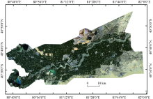
图1
阿拉尔垦区位置示意图"

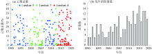
图2
遥感数据"


图3
技术流程图"


图4
NDVI最大值合成图"


图5
1990—2019年阿拉尔垦区NDVI年际变化"

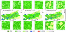
图6
3种分类方法的分类后结果比较"
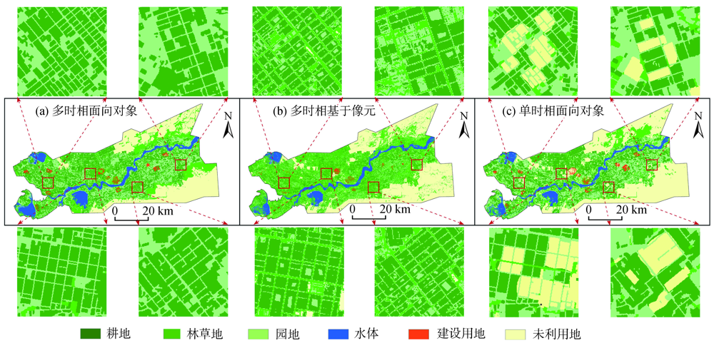
表1
阿拉尔垦区用地类型精度评价"
| 预测类别 | |||||||||
|---|---|---|---|---|---|---|---|---|---|
| 耕地 | 林草地 | 园地 | 水体 | 建设用地 | 未利用地 | 总计 | UA/% | ||
| 真实类别 | 耕地 | 24474 | 229 | 183 | 387 | 1 | 756 | 26030 | 94.02 |
| 林草地 | 148 | 63977 | 443 | 449 | 0 | 1292 | 66309 | 96.48 | |
| 园地 | 152 | 809 | 24921 | 686 | 0 | 588 | 27156 | 91.77 | |
| 水体 | 0 | 16 | 0 | 57601 | 99 | 2242 | 59958 | 96.07 | |
| 建设用地 | 0 | 1 | 0 | 44 | 5421 | 403 | 5869 | 92.37 | |
| 未利用地 | 0 | 7 | 0 | 2441 | 642 | 162761 | 165851 | 98.14 | |
| 总计 | 24774 | 65039 | 25547 | 61608 | 6163 | 168042 | 351173 | ||
| PA/% | 98.79 | 98.37 | 97.55 | 93.50 | 87.96 | 96.86 | OA/% | 98.79 | |
图7
阿拉尔垦区在斑块类型水平上的景观格局指数变化"
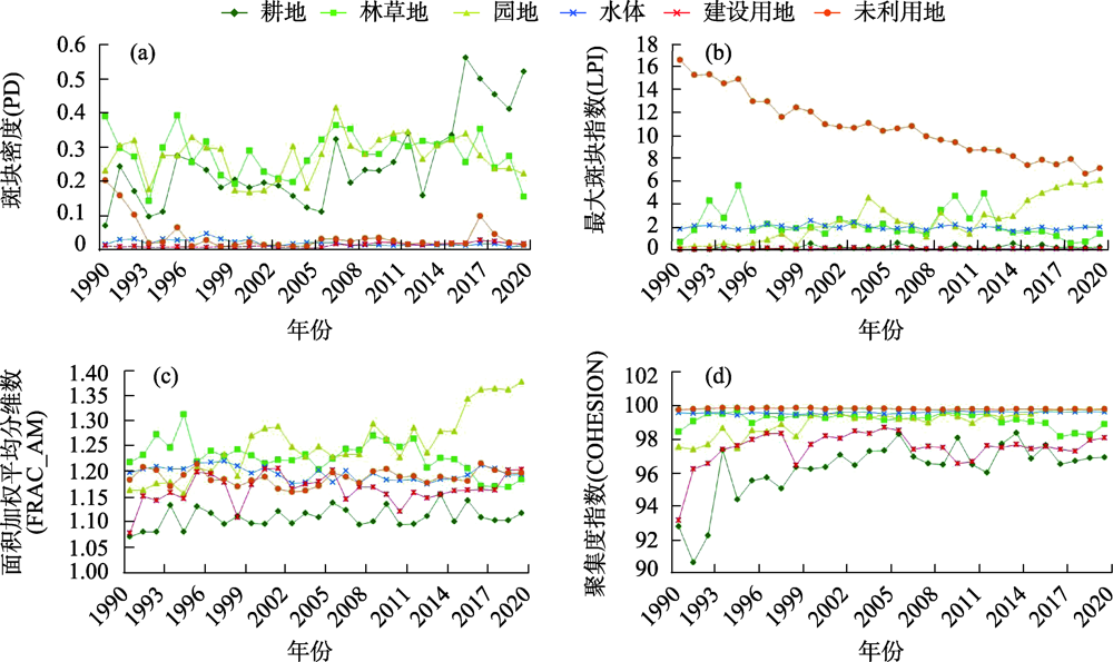
图8
阿拉尔垦区在景观水平上的景观格局指数变化"
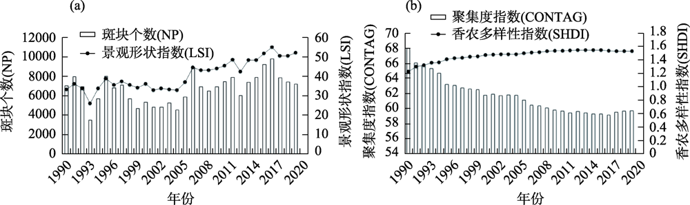

图9
阿拉尔垦区在景观水平上的突变分析"

表2
双样本K-S检验结果"
| NP | LSI | CONTAG | SHDI | |
|---|---|---|---|---|
| K-S检验Z值 | 1.830 | 2.132 | 2.407 | 2.252 |
| 双尾显著性检验(sig) | 0.002** | 0.000** | 0.000** | 0.000** |
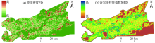
图10
基于移动窗口的景观格局分布"

| [1] |
Yu H, Liu X M, Kong B, et al. Landscape ecology development supported by geospatial technologies: A review[J]. Ecological Informatics, 2019, 51:185-192.
doi: 10.1016/j.ecoinf.2019.03.006 |
| [2] |
Chen L D, Liu Y, Lyu Y H, et al. Pattern analysis in landscape ecology: Progress, challenges and outlook[J]. Acta Ecologica Sinica, 2008, 28(11):5521-5531.
doi: 10.1016/S1872-2032(09)60011-1 |
| [3] | Wu J G. Landscape ecology[J]. Encyclopedia of Ecology(Second Edition), 2019, 4:527-531. |
| [4] |
Antrop M. The language of landscape ecologists and planners: A comparative content analysis of concepts used in landscape ecology[J]. Landscape and Urban Planning, 2001, 55(3):163-173.
doi: 10.1016/S0169-2046(01)00151-7 |
| [5] |
Wang L Y, Eagles P F J. Some theoretical considerations: From landscape ecology to waterscape ecology[J]. Acta Ecologica Sinica, 2009, 29(3):176-181.
doi: 10.1016/j.chnaes.2009.07.006 |
| [6] |
Hobbs R. Future landscapes and the future of landscape ecology[J]. Landscape and Urban Planning, 1997, 37(1-2):1-9.
doi: 10.1016/S0169-2046(96)00364-7 |
| [7] | Tagliafierro C, Longo A, Eetvelde V V, et al. Landscape economic valuation by integrating landscape ecology into landscape economics[J]. Environmental Science & Policy, 2013, 32:26-36. |
| [8] |
Zhou Y K, Ning L X, Bai X L. Spatial and temporal changes of human disturbances and their effects on landscape patterns in the Jiangsu coastal zone, China[J]. Ecological Indicators, 2018, 93:111-122.
doi: 10.1016/j.ecolind.2018.04.076 |
| [9] |
Zhang Q, Chen C L, Wang J Z, et al. The spatial granularity effect, changing landscape patterns, and suitable landscape metrics in the three gorges reservoir area, 1995-2015[J]. Ecological Indicators, 2020, 114:106259, doi: 10.1016/j.ecolind.2020.106259.
doi: 10.1016/j.ecolind.2020.106259 |
| [10] |
Lu J. Landscape ecology, urban morphology, and CBDs: An analysis of the columbus, ohio metropolitan area[J]. Applied Geography, 2015, 60:301-307.
doi: 10.1016/j.apgeog.2014.11.004 |
| [11] |
Li W J, Wang Y, Xie S Y, et al. Impacts of landscape multifunctionality change on landscape ecological risk in a megacity, China: A case study of Beijing[J]. Ecological Indicators, 2020, 117:106681, doi: 10.1016/j.ecolind.2020.106681.
doi: 10.1016/j.ecolind.2020.106681 |
| [12] |
Zhuang Q W, Wu S X, Yan Y Y, et al. Monitoring land surface thermal environments under the background of landscape patterns in arid regions: A case study in Aksu River basin[J]. Science of the Total Environment, 2020, 710(25):136336, doi: 10.1016/j.scitotenv.2019.136336.
doi: 10.1016/j.scitotenv.2019.136336 |
| [13] |
Wang L T, Wang S X, Zhou Y, et al. Landscape pattern variation, protection measures, and land use/land cover changes in drinking water source protection areas: A case study in Danjiangkou Reservoir, China[J]. Global Ecology and Conservation, 2020, 21:e00827, doi: 10.1016/j.gecco.2019.e00827.
doi: 10.1016/j.gecco.2019.e00827 |
| [14] |
Zhang L, Lu W X, Hou G L, et al. Coupled analysis on land use, landscape pattern and nonpoint source pollution loads in Shitoukoumen Reservoir watershed, China[J]. Sustainable Cities and Society, 2019, 51:101788, doi: 10.1016/j.scs.2019.101788.
doi: 10.1016/j.scs.2019.101788 |
| [15] |
Nowosad J, Stepinski T F. Global Inventory of landscape patterns and latent variables of landscape spatial configuration[J]. Ecological Indicators, 2018, 89:159-167.
doi: 10.1016/j.ecolind.2018.02.007 |
| [16] |
Zhang M, Wang J M, Li S J, et al. Dynamic changes in landscape pattern in a large-scale opencast coal mine area from 1986 to 2015: A complex network approach[J]. Gatena, 2020, 194:104738, doi: 10.1016/j.catena.2020.104738.
doi: 10.1016/j.catena.2020.104738 |
| [17] | 陈雪玲, 陈绍杰, 杜培军, 等. 基于多时相遥感影像的龙岩市景观格局变化分析[J]. 国土资源遥感, 2012, 24(2):132-137. |
| [ Chen Xueling, Chen Shaojie, Du Peijun, et al. A study of the landscape pattern change of Longyan city based on multi-temporal remote sensing images[J]. Remote Sensing For Land & Resources, 2012, 24(2):132-137. ] | |
| [18] | 朱永森, 曾永年, 张猛. 基于HJ卫星数据与面向对象分类的土地利用/覆盖信息提取[J]. 农业工程学报, 2017, 33(14):258-265. |
| [ Zhu Yongsen, Zeng Yongnian, Zhang Meng. Extract of land use/cover information based on HJ satellites data and object-oriented classification[J]. Transactions of the Chinese Society of Agricultural Engineering, 2017, 33(14):258-265. ] | |
| [19] | 高国林, 王石英, 蒋容. 翠屏区植被覆盖及其景观格局变化遥感分析[J]. 水土保持研究, 2013, 20(3):104-109. |
| [ Gao Guolin, Wang Shiying, Jang Rong. Remote sensing analysis on vegetation cover and landscape patterns change in Cuiping[J]. Research of Soil and Water Conservation, 2013, 20(3):104-109. ] | |
| [20] | 袁静文, 武辰, 杜博, 等. 高分五号高光谱遥感影像的城市土地利用景观格局分析[J]. 遥感学报, 2020, 24(4):465-478. |
| [ Yuan Jingwen, Wu Chen, Du Bo, et al. Analysis of landscape pattern on urban land use based on GF-5 hyperspectral data[J]. Journal of Remote Sensing, 2020, 24(4):465-478. ] | |
| [21] |
Kabisch N, Selsam P, Kirsten T, et al. A multi-sensor and multi-temporal remote sensing approach to detect land cover change dynamics in heterogeneous urban landscapes[J]. Ecological Indicators, 2019, 99:273-282.
doi: 10.1016/j.ecolind.2018.12.033 |
| [22] | 杜海燕, 周智彬, 刘凤山, 等. 绿洲化过程中阿拉尔垦区土壤粒径分形变化特征[J]. 干旱区研究, 2013, 30(4):615-622. |
| [ Du Haiyan, Zhou Zhibin, Liu Fengshan, et al. Variation of fractal dimension of soil particle size distribution in the Aral reclamation area in oasis development[J]. Arid Zone Research, 2013, 30(4):615-622. ] | |
| [23] |
Yushanjiang A, Zhang F, Yu H, et al. Quantifying the spatial correlations between landscape pattern and ecosystem service value: A case study in ebinur lake basin, Xinjiang, China[J]. Ecological Engineering, 2018, 113(1):94-104.
doi: 10.1016/j.ecoleng.2018.02.005 |
| [24] |
Wang X C, Dong X B, Liu H M, et al. Linking land use change, ecosystem services and human well-being: A case study of the manas river basin of Xinjiang, China[J]. Ecosystem Services, 2017, 27(A):113-123.
doi: 10.1016/j.ecoser.2017.08.013 |
| [25] | 朱金峰, 周艺, 王世新, 等. 1975—2018年白洋淀湿地变化分析[J]. 遥感学报, 2019, 23(5):971-986. |
| [ Zhu Jinfeng, Zhou Yi, Wang Shixin, et al. Analysis of changes of Baiyangdian wetland from 1975 to 2018 based on remote sensing[J]. Journal of Remote Sensing, 2019, 23(5):971-986. ] | |
| [26] | 邬建国. 景观生态学: 格局、过程、尺度与等级[M]. 北京: 高等教育出版社, 2000. |
| [ Wu Jianguo. Landscape Ecology: Pattern, Process, Scale and Hierarchy[M]. Beijing: Higher Education Press, 2000. ] | |
| [27] | 闫敏华, 邓伟, 陈泮勤. 三江平原气候突变分析[J]. 地理科学, 2003, 23(6):661-667. |
| [ Yan Minhua, Deng Wei, Chen Panqin. Analysis of climate jumps in the Sanjiang plain[J]. Scientia Geographica Sinica, 2003, 23(6):661-667. ] | |
| [28] | 夏芳. 钱塘江流域气候变化及其对水文径流的影响[D]. 杭州: 浙江大学, 2016. |
| [ Xia Fang. Climate Change in the Qiantang River Basin and Its Influence on Local Runoff[D]. Hangzhou: Zhejiang University, 2016. ] | |
| [29] | 宋奇 . 高琪, 马自强, 等. 1990—2019年阿拉尔垦区植被覆盖时空变化特征分析[J]. 草地学报, 2021, 29(5):1014-1024. |
| [ Song Qi, Gao Qi, Ma Ziqiang, et al. Characteristics of temporal and spatial variation of vegetation covers in Alar Reclamation area from 1990 to 2019[J]. Acta Agrestia Sinica, 2021, 29(5):1014-1024. ] | |
| [30] | 宋奇, 冯春晖, 高琪, 等. 阿拉尔垦区近30年耕地变化及其驱动因子分析[J]. 国土资源遥感, 2021, 33(2):202-212. |
| [ Song Qi, Feng Chunhui, Gao Qi, et al. Change of cultivated land and its driving factors in Alar reclamation area in the last 30 years[J]. Remote Sensing for Land and Resources, 2021, 33(2):202-212. ] | |
| [31] | 蔡利华. 阿拉尔垦区耕地养分现状与分布特征[D]. 新疆: 石河子大学, 2013. |
| [ Cai Lihua. The Status and Spatial Distribution of Soil Nutrient in Alar Reclamation Area[D]. Xinjiang: Shihezi University, 2013. ] | |
| [32] | 张艳波, 闫慧洁. 阿拉尔垦区自然灾害对农业经济影响的研究[J]. 数学的实践与认识, 2017, 47(1):286-290. |
| [ Zhang Yanbo, Yan Huijie. Effect of natural disaster on agricultural economy in Alar irrigated area[J]. Mathematics in Practice and Theory, 2017, 47(1):286-290. ] | |
| [33] | 张敏, 宫兆宁, 赵文吉, 等. 近30 年来白洋淀湿地景观格局变化及其驱动机制[J]. 生态学报, 2016, 36(15):4780-4791. |
| [ Zhang Ming, Gong Zhaoning, Zhao Wenji, et al. Landscape pattern change and the driving forces in Baiyangdian wetland from 1984 to 2014[J]. Acta Ecologica Sinica, 2016, 36(15):4780-4791. ] | |
| [34] | 周亚军, 刘廷玺, 段利民, 等. 锡林河流域上游河谷湿地景观格局演变及其驱动力[J]. 干旱区研究, 2020, 37(3):580-590. |
| [ Zhou Yajun, Liu Tingxi, Duan Limin, et al. Driving force analysis and landscape pattern evolution in the up stream valley of Xilin River Basin[J]. Arid Zone Research, 2020, 37(3):580-590. ] | |
| [35] |
Luo F, Liu Y, Peng J, et al. Assessing urban landscape ecological risk through an adaptive cycle framework[J]. Landscape and Urban Planning, 2018, 180:125-134.
doi: 10.1016/j.landurbplan.2018.08.014 |
| [36] |
Ning S K, Chang N B, Jeng K Y, et al. Soil erosion and non-point source pollution impacts assessment with the aid of multi-temporal remote sensing images[J]. Journal of environmental management, 2006, 79(1):88-101.
doi: 10.1016/j.jenvman.2005.05.019 |
| [37] | Wang L T, Wang S X, Zhou Y, et al. Landscape pattern variation, protection measures, and land use/land cover changes in drinking water source protection areas: A case study in Danjiangkou Reservoir, China[J]. Global Ecology and Conservation, 2020, 21:1-14. |
| [38] | 吴金华, 刘思雨, 白帅. 基于景观生态安全的神木市生态廊道识别与优化[J]. 干旱区研究, 2021, 38(4):1120-1127. |
| [ Wu Jinhua, Liu Siyu, Bai Shuai. Identification and optimization of ecological corridors in Shenmu City based on landscape ecological security[J]. Arid Zone Research, 2021, 38(4):1120-1127. ] | |
| [39] | 曾红霞, 赵成章, 王毓芳, 等. 盐池湾高寒湿地景观格局演变及其影响因素[J]. 干旱区研究, 2021, 38(6):1771-1781. |
| [ Zeng Hongxia, Zhao Chengzhang, Wang Yufang, et al. Landscape pattern evolution and its influencing factors of alpine wetland in Yanchi Bay[J]. Arid Zone Research, 2021, 38(6):1771-1781. ] | |
| [40] | 金梦婷, 徐丽萍, 徐权, 等. 基于FLUS-Markov模型的多情景景观生态风险评价与预测——以南疆克州为例[J]. 干旱区研究, 2021, 38(6):1793-1804. |
| [ Jin Mengting, Xu Liping, Xu Quan, et al. FLUS-Markov model-based multiscenario evaluation and prediction of the landscape ecological risk in Kezhou, South Xinjiang[J]. Arid Zone Research, 2021, 38(6):1793-1804. ] | |
| [41] | 宋奇. 阿拉尔垦区土地利用景观格局演变与生态风险评价研究[D]. 新疆: 塔里木大学, 2021. |
| [ Song Qi. Study on the Evolution of Land Use Landscape Pattern and Ecological Risk Evaluation in Aral Reclamation Area[D]. Xinjiang: Tarim University, 2021. ] | |
| [42] | 吕金霞, 蒋卫国, 王文杰, 等. 近30年来京津冀地区湿地景观变化及其驱动因素[J]. 生态学报, 2018, 38(12):4492-4503. |
| [ Lyu Jinxia, Jiang Weiguo, Wang Wenjie, et al. Wetland landscape pattern change and its driving forces in Beijing-Tianjin-Hebei region in recent 30 years[J]. Acta Ecologica Sinica, 2018, 38(12):4492-4503. ] |
| [1] | 洪国军, 谢俊博, 张灵, 范振岐, 喻彩丽, 付仙兵, 李旭. 基于多光谱影像的阿拉尔垦区棉田土壤盐分反演[J]. 干旱区研究, 2024, 41(5): 894-904. |
| [2] | 王昱, 李能安, 雒天峰, 张英, 袁兴鹏, 田苗, 信雅玲, 胡飞燕. 梨园河流域景观格局对地表水质的影响[J]. 干旱区研究, 2024, 41(11): 1831-1841. |
| [3] | 陆莹, 张敏, 王彦阁. 内蒙古黄河流域生态保护恢复优先区识别[J]. 干旱区研究, 2024, 41(11): 1946-1955. |
| [4] | 邹易, 蒙吉军. 干旱区绿洲-城镇-荒漠景观演变及生态环境效应[J]. 干旱区研究, 2023, 40(6): 988-1001. |
| [5] | 赵剑, 邓成军, 李文利, 赵金, 公延明, 李凯辉. 近35 a新疆天山巴音布鲁克草原退化程度评价[J]. 干旱区研究, 2023, 40(4): 636-646. |
| [6] | 张雨斯, 包玉海, 贺忠华. 1990—2021年内蒙古遥感生态环境质量变化及趋势分析——以呼伦贝尔市陈巴尔虎旗为例[J]. 干旱区研究, 2023, 40(2): 326-336. |
| [7] | 肖森天, 依力亚斯江·努尔麦麦提, 努尔比耶·穆合塔尔, 赵静, 阿迪莱·阿卜来提. 基于光学和雷达多源遥感的于田绿洲土壤盐渍化时空分析[J]. 干旱区研究, 2023, 40(1): 59-68. |
| [8] | 王靖文,唐志光,邓刚,胡国杰,桑国庆. 1991—2021年天山融雪末期雪线高度遥感监测研究[J]. 干旱区研究, 2022, 39(5): 1385-1397. |
| [9] | 张云霞,张金茜,巩杰. 半干旱区湖盆景观格局脆弱性及其影响因素——以凉城县为例[J]. 干旱区研究, 2022, 39(4): 1259-1269. |
| [10] | 文广超,李兴,吴冰洁,王晓鹤,谢洪波. 基于Landsat影像的柴达木盆地湖泊提取方法[J]. 干旱区研究, 2022, 39(3): 774-786. |
| [11] | 王毓芳,赵成章,曾红霞,康满萍,赵婷婷,唐玉瑞. 疏勒河中游湿地景观时空演变及其影响因素[J]. 干旱区研究, 2022, 39(1): 282-291. |
| [12] | 王让会,赵文斐,彭擎,刘春伟,周丽敏,田畅. 气候变化及景观格局与生态系统碳储存的耦合关系——以祁连山为例[J]. 干旱区研究, 2022, 39(1): 250-257. |
| [13] | 曾红霞,赵成章,王毓芳,李晓雅,赵婷婷,唐玉瑞. 盐池湾高寒湿地景观格局演变及其影响因素[J]. 干旱区研究, 2021, 38(6): 1771-1781. |
| [14] | 王晓峰,延雨,李月皓,张兴,符鑫鑫. 银川市湿地景观演变及其驱动因素[J]. 干旱区研究, 2021, 38(3): 855-866. |
| [15] | 王俊瑶, 怀保娟, 王叶堂, 孙维君, 张悟颖. 基于MOD10A1 的祁连山黑河流域典型冰川反照率时空变化研究[J]. 干旱区研究, 2020, 37(6): 1396-1405. |
|
||