干旱区研究 ›› 2024, Vol. 41 ›› Issue (10): 1699-1707.doi: 10.13866/j.azr.2024.10.08 cstr: 32277.14.AZR.20241008
李梦帆1( ), 郑江华1,2(), 钱安良1, 李家辉1, 阿迪力江·帕尔合提1, 王哲1,2, 马丽莎1,2, 王南1,2
收稿日期:2024-03-26
修回日期:2024-06-25
出版日期:2024-10-15
发布日期:2024-10-14
通讯作者:
郑江华. E-mail: zheng.jianghua@xju.edu.cn作者简介:李梦帆(2002-),男,主要研究方向为资源环境遥感. E-mail: l_mengfan@126.com
基金资助:
LI Mengfan1(), ZHENG Jianghua1,2(), QIAN Anliang1, LI Jiahui1, Adiljan PARHAT1, WANG Zhe1,2, MA Lisha1,2, WANG Nan1,2
Received:2024-03-26
Revised:2024-06-25
Published:2024-10-15
Online:2024-10-14
摘要:
天山位于亚欧大陆中部,是现代冰川的主要分布区之一,该地区冰川融水形成了数量多且分布广泛的冰湖。冰湖是气候变化的重要指示器,也是中国西北干旱与半干旱地区重要的地表水及地下水供给来源。由于地形因素和地物光谱特征的影响,使用单一的水体指数进行遥感影像的冰湖提取时,难以较好地区分出冰湖、山体阴影和积雪。本研究以天山地区为研究区,基于Google Earth Engine云平台,以Landsat 8遥感影像为数据源,根据冰湖的空间位置(缓冲区范围)、地形特征(坡度、高程)以及光谱特征,构建了冰湖决策树提取方法,并与NDWI(归一化水体指数)、MNDWI(改进的归一化水体指数)阈值法进行了精度比较。结果表明:决策树法能够有效减小山体阴影和积雪影响,更有效地提取冰湖信息,提取结果总体精度为89.14%,Kappa系数为0.783,F1分数为87.85%。结合了空间位置、地形特征和光谱特征的决策树方法为冰湖的动态监测与研究分析提供了一种较为高效的提取方法。
李梦帆, 郑江华, 钱安良, 李家辉, 阿迪力江·帕尔合提, 王哲, 马丽莎, 王南. 基于决策树的天山冰湖提取方法研究[J]. 干旱区研究, 2024, 41(10): 1699-1707.
LI Mengfan, ZHENG Jianghua, QIAN Anliang, LI Jiahui, Adiljan PARHAT, WANG Zhe, MA Lisha, WANG Nan. Research on the extraction method of Tianshan glacier lake based on decision tree[J]. Arid Zone Research, 2024, 41(10): 1699-1707.

图1
研究区概况图 注:底图采用自然资源部标准地图制作,审图号为GS(2021)5453号,对底图边界无修改。下同。"


图2
技术路线图"
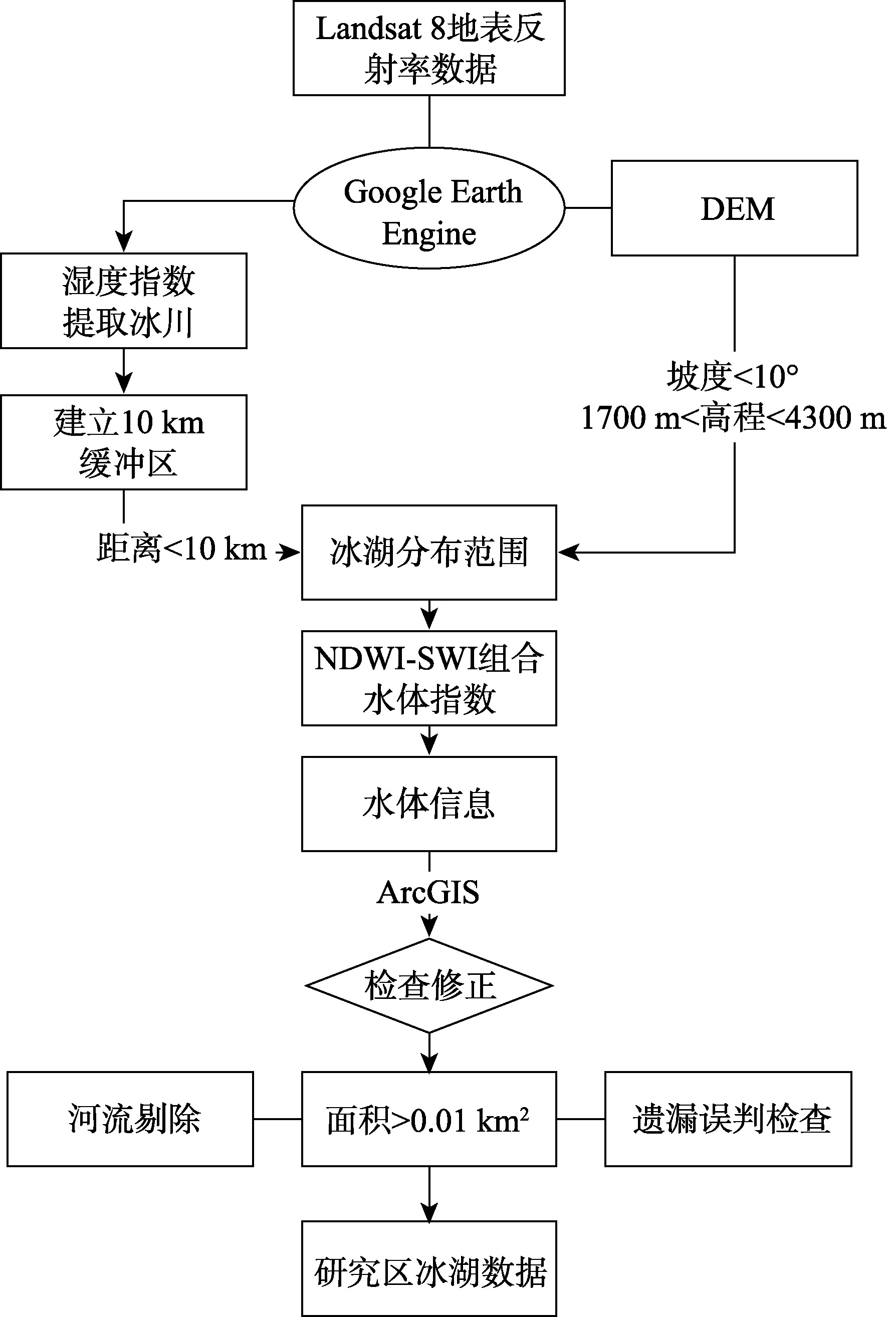
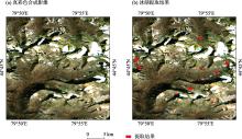
图3
局部地区冰湖提取结果"

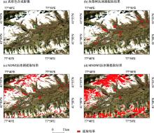
图4
冰湖提取结果对比"

表1
天山冰湖提取精度混淆矩阵"
| 验证样点 | 总计 | 用户精度/% | ||
|---|---|---|---|---|
| 冰湖 | 非冰湖 | |||
| 冰湖 | 1374 | 4 | 1378 | 99.71 |
| 非冰湖 | 376 | 1746 | 2122 | 82.28 |
| 总计 | 1750 | 1750 | 总体精度:89.14% | |
| 生产者精度/% | 78.51 | 99.77 | Kappa系数:0.783 | |
表2
天山冰湖提取精度"
| 准确率/% | 召回率/% | F1分数/% |
|---|---|---|
| 99.71 | 78.51 | 87.85 |
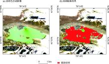
图5
冰湖提取误差分析"

| [1] | 黄启厅. 干旱区山地冰川—冰湖协同演变遥感监测与气候变化响应机制研究[D]. 北京: 中国科学院大学 (中国科学院遥感与数字地球研究所), 2017. |
| [Huang Qiting. Study on Remotely Sensed Monitoring of the Synergic Evolution of Alpine Glacier-Glacier Lakes and Their Response Mechanism to the Climate Change in the Arid Areas[D]. Beijing: Institute of Remote Sensing and Digital Earth Chinese Academy of Sciences, 2017.] | |
| [2] | 李想. 基于 GEE 的近三十年亚洲高山区冰川雪线变化研究[D]. 西安: 西北大学, 2021. |
| [Li Xiang. Research on Glacier Snowline Changes in High Mountain Asia in the Past 30 Years Using GEE[D]. Xi’an: Northwest University, 2021.] | |
| [3] | 姚檀栋, 刘时银, 蒲健辰, 等. 高亚洲冰川的近期退缩及其对西北水资源的影响[J]. 中国科学(D辑), 2004, 34(6): 535-543. |
| [Yao Tandong, Liu Shiyin, Pu Jianchen, et al. Recent retreat of high Asian glaciers and their impact on northwest water resources[J]. Science China Earth Sciences, 2004, 34(6): 535-543.] | |
| [4] |
邓海军, 陈亚宁. 中亚天山山区冰雪变化及其对区域水资源的影响[J]. 地理学报, 2018, 73(7): 1309-1323.
doi: 10.11821/dlxb201807010 |
|
[Deng Haijun, Chen Yaning. The glacier and snow variations and their impact on water resources in mountain regions: A case study in Tianshan Mountains of Central Asia[J]. Acta Geographica Sinica, 2018, 73(7): 1309-1323.]
doi: 10.11821/dlxb201807010 |
|
| [5] | 王宗太. 新疆的冰川[J]. 干旱区地理, 1991, 14(1): 18-24. |
| [Wang Zongtai. The glaicer of Xinjiang[J]. Arid Land Geography, 1991, 14(1): 18-24.] | |
| [6] |
姚晓军, 刘时银, 韩磊, 等. 冰湖的界定与分类体系——面向冰湖编目和冰湖灾害研究[J]. 地理学报, 2017, 72(7): 1173-1183.
doi: 10.11821/dlxb201707004 |
|
[Yao Xiaojun, Liu Shiyin, Han Lei, et al. Definition and classification systems of glacial lake for inventory and hazards study[J]. Acta Geographica Sinica, 2017, 72(7): 1173-1183.]
doi: 10.11821/dlxb201707004 |
|
| [7] |
陈晨, 郑江华, 刘永强, 等. 近 20 年中国阿尔泰山区冰川湖泊对区域气候变化响应的时空特征[J]. 地理研究, 2015, 34(2): 270-284.
doi: 10.11821/dlyj201502007 |
| [Chen Chen, Zheng Jianghua, Liu Yongqiang, et al. The response of glacial lakes in the Altay Mountains of China to climate change during 1992-2013[J]. Geographical Research, 2015, 34(2): 270-284.] | |
| [8] | 毕海芸, 王思远, 曾江源, 等. 基于TM影像的几种常用水体提取方法的比较和分析[J]. 遥感信息, 2012, 27(5): 77-82. |
| [Bi Haiyun, Wang Siyuan, Zeng Jiangyuan, et al. Comparison and analysis of several common water extraction methods based on TM lmage[J]. Remote Sensing Information, 2012, 27(5): 77-82.] | |
| [9] |
Wang X, Guo X, Yang C, et al. Glacial lake inventory of high-mountain Asia in 1990 and 2018 derived from Landsat images[J]. Earth System Science Data, 2020, 12(3): 2169-2182.
doi: 10.5194/essd-12-2169-2020 |
| [10] | 骆剑承, 盛永伟, 沈占锋, 等. 分步迭代的多光谱遥感水体信息高精度自动提取[J]. 遥感学报, 2009, 13(4): 610-615. |
| [Luo Jiancheng, Sheng Yongwei, Shen Zhanfeng, et al. Step by step iterative multi-spectral remote sensing water information extraction with high precision[J]. National Remote Sensing Bulletin, 2009, 13(4): 610-615.] | |
| [11] | Govindha Raj B K, Kumar V K, SN R. Remote sensing-based inventory of glacial lakes in Sikkim Himalaya: Semi-automated approach using satellite data[J]. Geomatics, Natural Hazards and Risk, 2013, 4(3): 241-253. |
| [12] | Mitkari K V, Arora M K, Tiwari R K. Extraction of glacial lakes in Gangotri glacier using object-based image analysis[J]. IEEE Journal of Selected Topics in Applied Earth Observations and Remote Sensing, 2017, 10(12): 5275-5283. |
| [13] | 闫斌, 贾洪果, 任文静, 等. 基于NDWI-NDSI组合阈值法的布加岗日冰湖提取及其变化分析[J]. 遥感学报, 2022, 26(11): 2344-2353. |
| [Yan Bin, Jia Hongguo, Ren Wenjing, et al. Glacier lake extraction and variation analysis of the Bujiagangri glacier based on the NDWI-NDSI combination threshold method[J]. National Remote Sensing Bulletin, 2022, 26(11): 2344-2353.] | |
| [14] |
陈方, 王金晓, 张美美, 等. 基于历史边界的喜马拉雅山脉冰湖提取方法对比研究[J]. 冰川冻土, 2023, 45(4): 1413-1427.
doi: 10.7522/j.issn.1000-0240.2023.0108 |
|
[Chen Fang, Wang Jinxiao, Zhang Meimei, et al. Comparative study on the extraction methods of Himalayan glacial lakes based on historical boundaries[J]. Journal of Glaciology and Geocryology, 2023, 45(4): 1413-1427.]
doi: 10.7522/j.issn.1000-0240.2023.0108 |
|
| [15] | 李宇宸, 张军, 刘陈立. Sentinel-2 影像的云南千湖山细小冰湖提取方法[J]. 测绘科学, 2021, 46(4): 114-120. |
| [Li Yuchen, Zhang Jun, Liu Chenli. Extraction method of alpine small lacial lake in Qianhu Mountain area of Yunnan province based on Sentinel-2 image[J]. Science of Surveying and Mapping, 2021, 46(4): 114-120.] | |
| [16] | Ronneberger O, Fischer P, Brox T. U-net: Convolutional networks for biomedical image segmentation[C]//Medical image computing and computer-assisted intervention-MICCAI 2015: 18th international conference, Munich, Germany, October 5-9, 2015, proceedings, part III 18. Springer International Publishing, 2015: 234-241. |
| [17] | Li J, Sheng Y. An automated scheme for glacial lake dynamics mapping using Landsat imagery and digital elevation models: A case study in the Himalayas[J]. International Journal of Remote Sensing, 2012, 33(16): 5194-5213. |
| [18] | 潘梦, 曹云刚. 高亚洲地区冰湖遥感研究进展与展望[J]. 自然资源遥感, 2021, 33(1): 1-8. |
| [Pan Meng, Cao Yungang. Present status and perspectives of remote sensing survey of glacial lakes in High Asia[J]. Remote Sensing for Natural Resources, 2021, 33(1): 1-8.] | |
| [19] | Jain S K, Sinha R K, Chaudhary A, et al. Expansion of a glacial lake, Tsho Chubda, Chamkhar Chu Basin, Hindukush Himalaya, Bhutan[J]. Natural Hazards, 2015, 75: 1451-1464. |
| [20] | Veh G, Korup O, Roessner S, et al. Detecting Himalayan glacial lake outburst floods from Landsat time series[J]. Remote Sensing of Environment, 2018, 207: 84-97. |
| [21] | Bhardwaj A, Singh M K, Joshi P K, et al. A lake detection algorithm (LDA) using Landsat 8 data: A comparative approach in glacial environment[J]. International Journal of Applied Earth Observation and Geoinformation, 2015, 38: 150-163. |
| [22] | 吴坤鹏. 天山冰湖变化及其影响研究[D]. 湘潭: 湖南科技大学, 2014. |
| [Wu Kunpeng. The Change of Glacial Lake and Its Influence in Tianshan Mountains[D]. Xiangtan: Hunan University of Science and Technology, 2014.] | |
| [23] | 车涛, 李新, Mool P K, 等. 希夏邦马峰东坡冰川与冰川湖泊变化遥感监测[J]. 冰川冻土, 2005, 27(6): 801-805. |
| [Che Tao, Li Xin, Mool P K, et al. Monitoring glaciers and associated glacial lakes on the east slopes of mount Xixabangma from remote sensing images[J]. Journal of Glaciology and Geocryology, 2005, 27(6): 801-805.] | |
| [24] |
陈亚宁, 李稚, 方功焕, 等. 气候变化对中亚天山山区水资源影响研究[J]. 地理学报, 2017, 72(1): 18-26.
doi: 10.11821/dlxb201701002 |
|
[Chen Yaning, Li Zhi, Fang Gonghuan, et al. lmpact of climate change on water resources in the Tianshan Mountians, Central Asia[J]. Acta Geographica Sinica, 2017, 72(1): 18-26.]
doi: 10.11821/dlxb201701002 |
|
| [25] | Gardelle J, Arnaud Y, Berthier E. Contrasted evolution of glacial lakes along the Hindu Kush Himalaya mountain range between 1990 and 2009[J]. Global and Planetary Change, 2011, 75(1-2): 47-55. |
| [26] |
Jain R M, Mody K, Mishra A, et al. Physicochemical characterization of biosurfactant and its potential to remove oil from soil and cotton cloth[J]. Carbohydrate Polymers, 2012, 89(4): 1110-1116.
doi: 10.1016/j.carbpol.2012.03.077 pmid: 24750921 |
| [27] | Richardson S D, Reynolds J M. An overview of glacial hazards in the Himalayas[J]. Quaternary International, 2000, 65: 31-47. |
| [28] | 殷永胜, 王欣, 刘时银, 等. 1990—2020年中国冰湖变化特征及影响因素[J]. 湖泊科学, 2023, 35(1): 358-367. |
| [Yin Yongsheng, Wang Xin, Liu Shiyin, et al. Characteristics and influence factors of the glacial lake changes in China from 1990 to 2020[J]. Journal of Lake Sciences, 2023, 35(1): 358-367.] | |
| [29] | Crist E P, Kauth R J. The tasseled cap de-mystified[J]. Photogrammetric Engineering and Remote Sensing, 1986, 52: 81-86. |
| [30] | Crist E P. A TM tasseled cap equivalent transformation for reflectance factor data[J]. Remote sensing of Environment, 1985, 17(3): 301-306. |
| [31] | 周远刚, 赵锐锋, 张丽华, 等. 博格达峰地区冰川和积雪变化遥感监测及影响因素分析[J]. 干旱区地理, 2019, 42(6): 1395-1403. |
| [Zhou Yuangang, Zhao Ruifeng, Zhang Lihua, et al. Remote sensing monitoring of the change of glacier and snow cover and its influencing factors in Mount Bogda[J]. Arid Land Geography, 2019, 42(6): 1395-1403.] | |
| [32] | 王欣, 刘时银, 姚晓军, 等. 我国喜马拉雅山区冰湖遥感调查与编目[J]. 地理学报, 2010, 65(1): 29-36. |
|
[Wang Xin, Liu Shiyin, Yao Xiaojun, et al. Glacier lake investigation and inventory in the Chinese Himalayas based on the remote sensing data[J]. Acta Geographica Sinica, 2010, 65(1): 29-36.]
doi: 10.11821/xb201001004 |
|
| [33] | 杨成德, 王欣, 魏俊锋, 等. 2015年中国西部冰湖编目数据集[J]. 中国科学数据(中英文网络版), 2018, 3(4): 36-44. |
| [Yang Chengde, Wang Xin, Wei Junfeng, et al. A dataset of glacial lake inventory of West China in 2015[J]. China Scientific Data, 2018, 3(4): 36-44.] | |
| [34] | McFeeters S K. The use of the Normalized Difference Water Index (NDWI) in the delineation of open water features[J]. International Journal of Remote Sensing, 1996, 17(7): 1425-1432. |
| [35] | 陈文倩, 丁建丽, 李艳华, 等. 基于国产 GF-1 遥感影像的水体提取方法[J]. 资源科学, 2015, 37(6): 1166-1172. |
| [Chen Wenqian, Ding Jianli, Li Yanhua, et al. Extraction of water information based on China-made GF-1 remote sense image[J]. Resources Science, 2015, 37(6): 1166-1172.] | |
| [36] | 丁占峰, 李大军. 基于 ONDWI 水体指数的鄱阳湖水域信息提取[J]. 安徽农业科学, 2015, 43(6): 348-350. |
| [Ding Zhanfeng, Li Dajun. The water region extraction of the Poyang Lake based on the ONDWI[J]. Journal of Anhui Agricultural Sciences, 2015, 43(6): 348-350.] | |
| [37] | 都金康, 黄永胜, 冯学智, 等. SPOT 卫星影像的水体提取方法及分类研究[J]. 遥感学报, 2001, 5(3): 214-219. |
| [Du Jinkang, Huang Yongsheng, Feng Xuezhi, et al. Study on water bodies extraction and classification from SPOT image[J]. National Remote Sensing Bulletin, 2001, 5(3): 214-219.] | |
| [38] |
文广超, 李兴, 吴冰洁, 等. 基于 Landsat 影像的柴达木盆地湖泊提取方法[J]. 干旱区研究, 2022, 39(3): 774-786.
doi: 10.13866/j.azr.2022.03.11 |
|
[Wen Guangchao, Li Xing, Wu Bingjie, et al. An automatic method for delineating lake surfaces in Qaidam Basin using Landsat images[J]. Arid Zone Research, 2022, 39(3): 774-786.]
doi: 10.13866/j.azr.2022.03.11 |
|
| [39] | 徐涵秋. 利用改进的归一化差异水体指数 (MNDWI) 提取水体信息的研究[J]. 遥感学报, 2005, 9(5): 589-595. |
| [Xu Hanqiu. A study on information extraction of water body with the Modified Normalized Difference Water lndex (MNDWI)[J]. National Remote Sensing Bulletin, 2005, 9(5): 589-595.] | |
| [40] | Foody G M. Explaining the unsuitability of the kappa coefficient in the assessment and comparison of the accuracy of thematic maps obtained by image classification[J]. Remote Sensing of Environment, 2020, 239: 111630. |
| [1] | 张彬, 郑新军, 王玉刚, 唐立松, 李彦, 杜澜, 田胜川. 1990—2022年天山北坡地区不同开垦年限耕层土壤盐分变化[J]. 干旱区研究, 2024, 41(9): 1435-1445. |
| [2] | 李宇航, 余文学, 杨永均, 朱燕峰, 马静, 陈浮. 近60 a天山北坡经济带天然径流量时空变化及归因识别[J]. 干旱区研究, 2024, 41(9): 1446-1455. |
| [3] | 周杰, 王旭虎, 杜维波, 周晓雷, 杨洁, 张晓玮. 气候变化背景下的天山云杉潜在分布区预测[J]. 干旱区研究, 2024, 41(7): 1167-1176. |
| [4] | 张顺鑫, 吴子豪, 闫庆武, 李桂娥, 牟守国. 基于PLUS-InVEST模型的天山北坡生态系统碳储量时空变化与预测[J]. 干旱区研究, 2024, 41(7): 1228-1237. |
| [5] | 赵雨琪, 魏天兴. 1990—2020年黄土高原典型县域植被覆盖变化及影响因素[J]. 干旱区研究, 2024, 41(1): 147-156. |
| [6] | 姚金玺, 肖成志, 张志, 王浪, 张焜. 基于GEE多源遥感数据的干旱区植被地物类型提取[J]. 干旱区研究, 2024, 41(1): 157-168. |
| [7] | 陈春波,李均力,赵炎,夏江,田伟涛,李超锋. 新疆草地时空动态及其对气候变化的响应——以昌吉回族自治州为例[J]. 干旱区研究, 2023, 40(9): 1484-1497. |
| [8] | 周小东, 常顺利, 王冠正, 张毓涛, 喻树龙, 张同文. 天山北坡中段雪岭云杉径向生长对气候变化的响应[J]. 干旱区研究, 2023, 40(8): 1215-1228. |
| [9] | 李小雨, 贾科利, 魏慧敏, 陈睿华, 王怡婧. 基于随机森林算法的土壤含盐量预测[J]. 干旱区研究, 2023, 40(8): 1258-1267. |
| [10] | 鲁元波, 严成, 宋春武, 李雅娟, 来赪雲. 天山南坡山前荒漠草地植物群落分布对环境因子的响应——以拜城县为例[J]. 干旱区研究, 2023, 40(8): 1346-1357. |
| [11] | 张丽娟, 杜瀚, 贠丰泽, 马应辉, 张新强, 阿瓦古丽·图尔荪, 马正海. 天山乌鲁木齐河源1号冰川表层雪微生物多样性分析[J]. 干旱区研究, 2023, 40(4): 670-680. |
| [12] | 李红梅, 巴贺贾依娜尔·铁木尔别克, 常顺利, 古丽哈娜提·波拉提别克, 张毓涛, 李吉枚. MixSIAR和IsoSource模型对比分析天山北坡不同灌木的夏季水分来源[J]. 干旱区研究, 2023, 40(3): 445-455. |
| [13] | 何捷, 王璞玉, 李宏亮, 李忠勤, 周平, 牟建新, 余凤臣, 戴玉萍. 托木尔峰青冰滩72号冰川表碛区夏季消融模拟研究[J]. 干旱区研究, 2023, 40(10): 1595-1607. |
| [14] | 王冠正, 常顺利, 王建萍, 张毓涛, 孙雪娇, 李翔. 不同坡向雪岭云杉天然更新影响因素分析[J]. 干旱区研究, 2023, 40(10): 1661-1669. |
| [15] | 周翔, 王鹏, 布玛丽亚穆·麦麦提, 王秋琰, 岳健. 新疆天山东部森林地表可燃物的热值研究[J]. 干旱区研究, 2023, 40(10): 1670-1677. |
|
||