干旱区研究 ›› 2023, Vol. 40 ›› Issue (6): 949-957.doi: 10.13866/j.azr.2023.06.10 cstr: 32277.14.AZR.20230610
赵艳芬1( ),潘伯荣2()
收稿日期:2022-08-27
修回日期:2023-03-13
出版日期:2023-06-15
发布日期:2023-06-21
作者简介:赵艳芬(1987-),女,博士,讲师,主要从事干旱区生物地理学研究. E-mail: 基金资助:
ZHAO Yanfen1(),PAN Borong2()
Received:2022-08-27
Revised:2023-03-13
Published:2023-06-15
Online:2023-06-21
摘要:
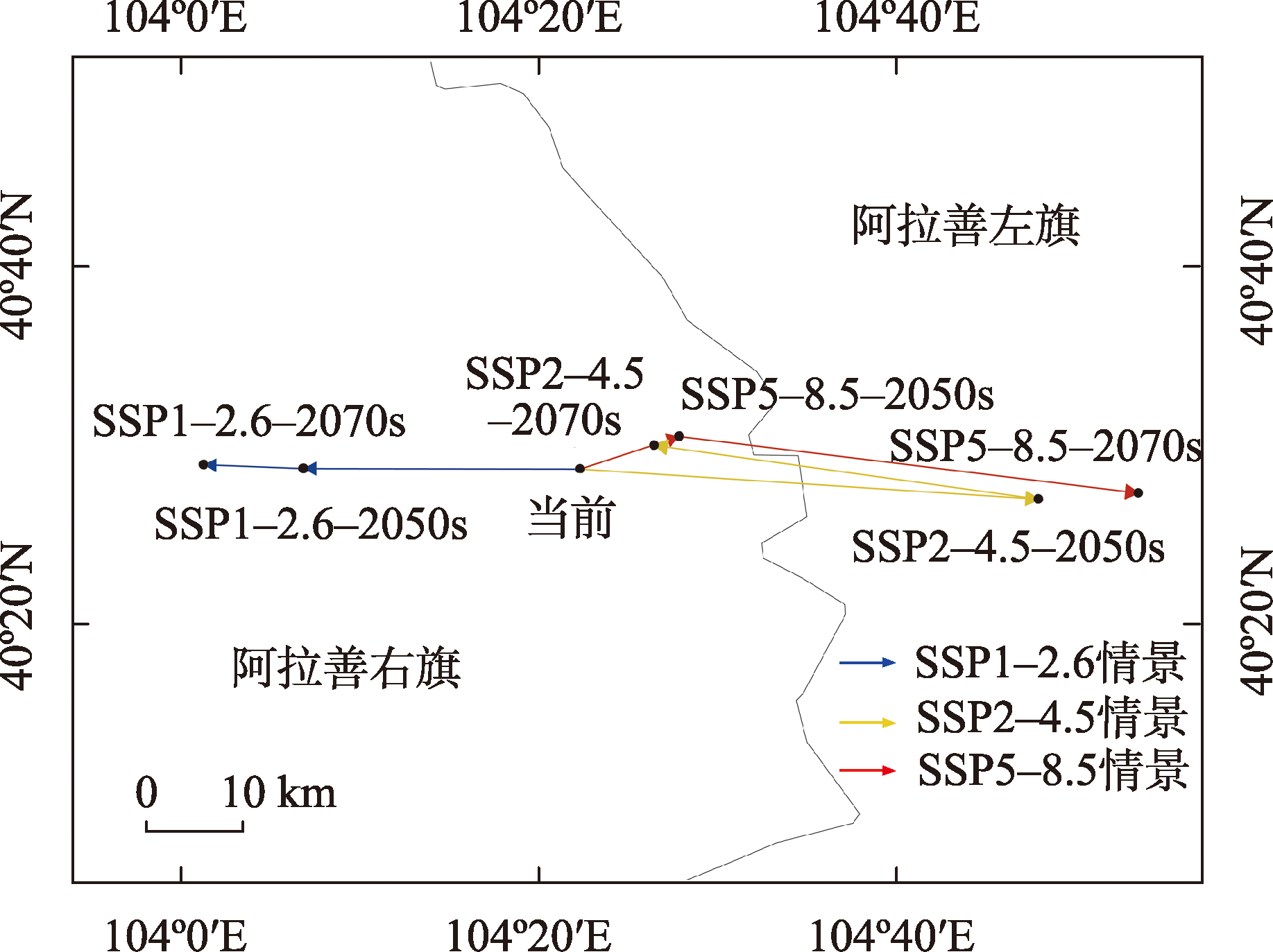
革苞菊属(Tugarinovia Iljin)为阿拉善荒漠特有属,预测气候变化对革苞菊属潜在地理分布的影响对其保护至关重要。本研究基于革苞菊属当前在中国的34个分布点和22个环境变量,利用最大熵(MaxEnt)模型模拟当前和未来(2050s、2070s)3种共享社会经济路径下(SSP1-2.6、SSP2-4.5和SSP5-8.5)革苞菊属在中国的分布格局变化,采用ROC曲线下方的面积AUC值检验模型预测效果,以刀切法和综合贡献率分析影响其分布的主要环境因子。结果表明:(1) MaxEnt模型模拟准确度较高(AUC=0.992);海拔、最暖季度降水量、最冷季度降水量和年平均温度是影响革苞菊属地理分布的主导环境因子。(2) 当前革苞菊属适生区面积和高适生区面积范围均较小,适生区面积为37.08×10⁴ km2,高适生区面积为6.89×10⁴ km2,主要沿着阴山和贺兰山一带呈破碎化分布。(3) 未来3种气候情景下革苞菊属高适生区面积总体呈增加趋势,且在SSP5-8.5气候情景下增加幅度较大;其适生区质心主要向东(阿拉善左旗)迁移。
赵艳芬, 潘伯荣. 气候变化情景下革苞菊属在中国的潜在地理分布[J]. 干旱区研究, 2023, 40(6): 949-957.
ZHAO Yanfen, PAN Borong. Potential geographical distributions of Tugarinovia in China under climate change scenarios[J]. Arid Zone Research, 2023, 40(6): 949-957.

图1
当前革苞菊属在中国的分布点及其适生分布区"
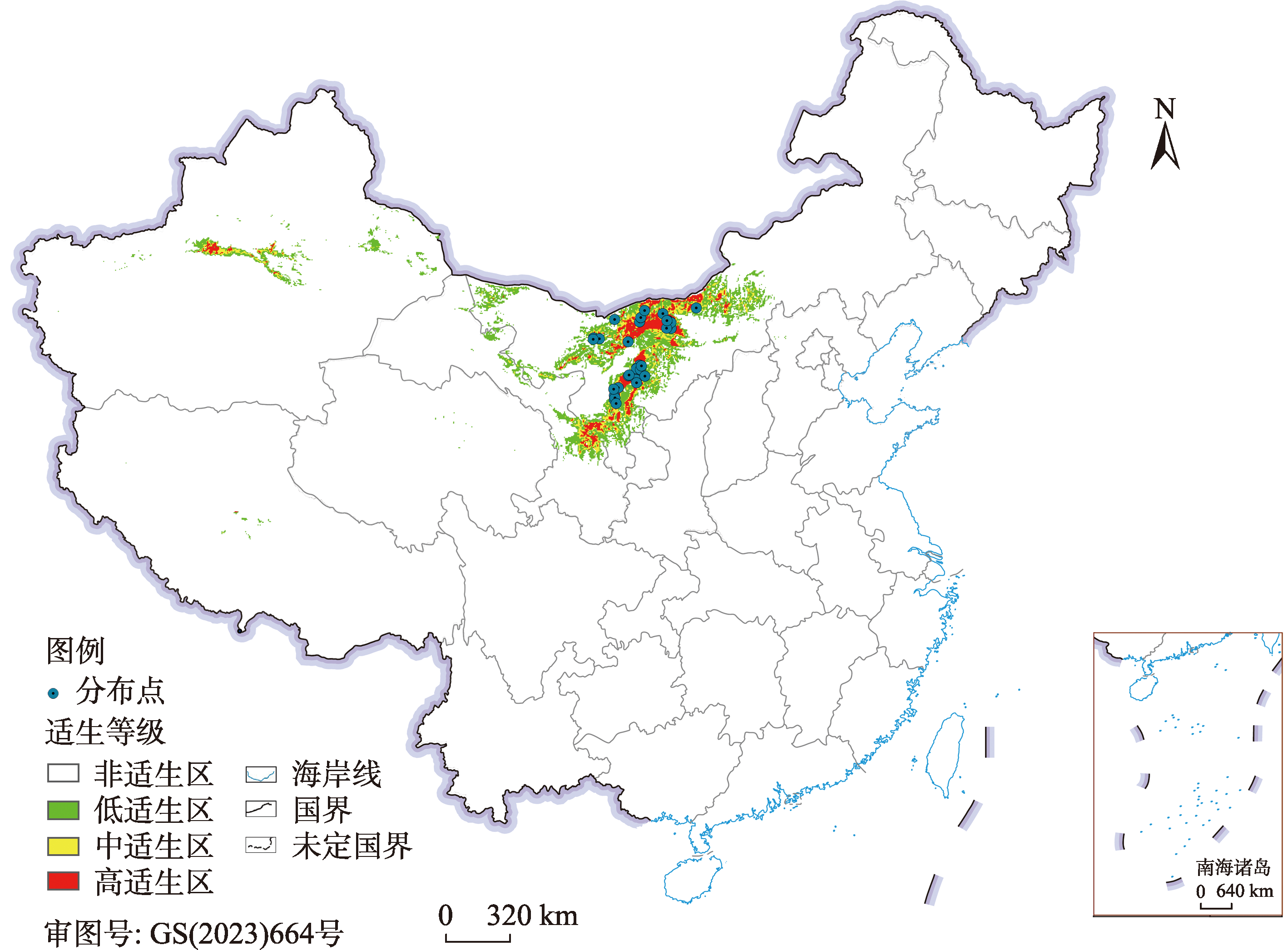

图2
MaxEnt模型的ROC检验"
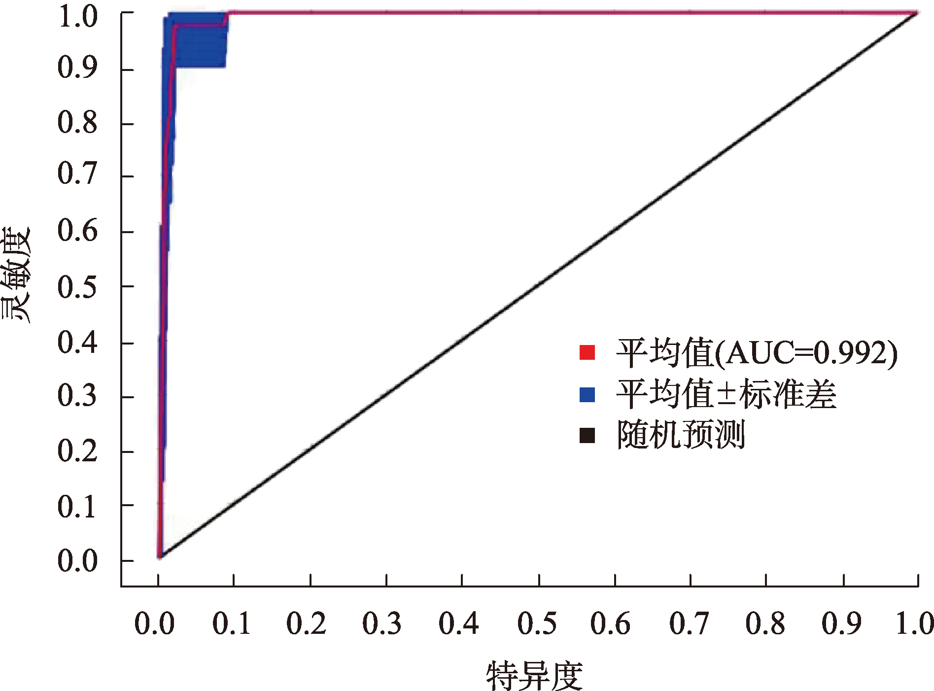
表1
环境变量及其贡献率"
| 类型 | 环境变量 | 描述 | 贡献率/% |
|---|---|---|---|
| 气候因子 | Bio18 | 最暖季度降水量 | 22.2 |
| Bio19 | 最冷季度降水量 | 20.3 | |
| Bio2 | 平均气温日较差 | 9.2 | |
| Bio4 | 温度季节性变化 | 8.5 | |
| Bio11 | 最冷季节平均温度 | 7.5 | |
| Bio15 | 降水量季节性变化 | 1.9 | |
| Bio3 | 等温性 | 1.5 | |
| Bio1 | 年平均温度 | 0.2 | |
| 地形因子 | Ele | 海拔 | 22.4 |
| Slope | 坡度 | 4 | |
| Aspect | 坡向 | 2.3 |

图3
利用刀切法检测环境变量对革苞菊属分布影响的重要性"

表2
革苞菊属不同时期在中国的潜在适生区面积"
| 时期 | 总适生区 | 高适生区 | 中适生区 | 低适生区 |
|---|---|---|---|---|
| 当前 | 37.08 | 6.89 | 7.53 | 22.66 |
| 2050s(SSP1-2.6) | 36.12 | 7.13 | 6.94 | 22.05 |
| 2070s(SSP1-2.6) | 38.64 | 7.18 | 7.90 | 23.56 |
| 2050s(SSP2-4.5) | 33.87 | 7.34 | 7.07 | 19.46 |
| 2070s(SSP2-4.5) | 37.52 | 7.12 | 7.97 | 22.43 |
| 2050s(SSP5-8.5) | 37.43 | 7.43 | 8.09 | 21.91 |
| 2070s(SSP5-8.5) | 39.03 | 8.28 | 8.37 | 22.38 |
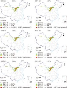
图4
不同气候情景下革苞菊属在中国的潜在分布区"


图5
不同气候情景下革苞菊属在中国的迁移路径"
| [1] | 方精云, 朱江玲, 石岳. 生态系统对全球变暖的响应[J]. 科学通报, 2018, 63(2): 136-140. |
| [Fang Jingyun, Zhu Jiangling, Shi Yue. The responses of ecosystems to global warming[J]. Chinese Science Bulletin, 2018, 63(2): 136-140.] | |
| [2] |
王文婷, 杨婷婷, 金磊, 等. 未来气候变化下两种红景天植物的脆弱性[J]. 生物多样性, 2021, 29(12): 1620-1628.
doi: 10.17520/biods.2021209 |
|
[Wang Wenting, Yang Tingting, Jin Lei, et al. Vulnerability of two Rhodiola species under climate change in the future[J]. Biodiversity Science, 2021, 29(12): 1620-1628.]
doi: 10.17520/biods.2021209 |
|
| [3] |
贺晓慧, 司建华, 赵春彦, 等. 西藏沙棘(Hippophae thibetana)潜在地理分布及其对未来气候变化的响应模拟[J]. 中国沙漠, 2021, 41(3): 101-109.
doi: 10.7522/j.issn.1000-694X.2021.00028 |
|
[He Xiaohui, Si Jianhua, Zhao Chunyan, et al. Potential distribution of Hippophae thibetana and its predicted responses to climate change[J]. Journal of Desert Research, 2021, 41(3): 101-109.]
doi: 10.7522/j.issn.1000-694X.2021.00028 |
|
| [4] | 吴建国, 吕佳佳, 周巧富. 我国珍稀濒危物种适应气候变化的对策探讨[J]. 中国人口·资源与环境, 2011, 21(3): 566-570. |
| [Wu Jianguo, Lv Jiajia, Zhou Qiaofu. Strategies of adaptation to climate change for rare or endangered species in China[J]. China Population, Resources and Environment, 2011, 21(3): 566-570.] | |
| [5] |
Qu H, Wang C J, Zhang Z X. Planning priority conservation areas under climate change for six plant species with extremely small populations in China[J]. Nature Conservation, 2018, 25: 89-106.
doi: 10.3897/natureconservation.25.20063 |
| [6] | 冉巧, 卫海燕, 赵泽芳, 等. 气候变化对孑遗植物银杉的潜在分布及生境破碎度的影响[J]. 生态学报, 2019, 39(7): 2481-2493. |
| [Ran Qiao, Wei Haiyan, Zhao Zefang, et al. Impact of climate change on the potential distribution and habitat fragmentation of the relict plant Cathaya argyrophylla Chun et Kuang[J]. Acta Ecologica Sinica, 2019, 39(7): 2481-2493.] | |
| [7] | 刘文胜, 游简舲, 曾文斌, 等. 气候变化下青藏苔草地理分布的预测[J]. 中国草地学报, 2018, 40(5): 43-49. |
| [Liu Wensheng, You Jianling, Zeng Wenbin, et al. Prediction of the geographical distribution of Carex moorcroftii under global climate change based on Maxent model[J]. Chinese Journal of Grassland, 2018, 40(5): 43-49.] | |
| [8] |
Elith J, Leathwick J R. Species distribution models: Ecological explanation and prediction across space and time[J]. Annual Review of Ecology, Evolution, and Systematics, 2009, 40(1): 677-697.
doi: 10.1146/ecolsys.2009.40.issue-1 |
| [9] | 张亮, 魏彦强, 王金牛, 等. 气候变化情景下黑果枸杞的潜在地理分布[J]. 应用与环境生物学报, 2020, 26(4): 969-978. |
| [Zhang Liang, Wei Yanqiang, Wang Jinniu, et al. The potential geographical distribution of Lycium ruthenicum Murr. under different climate change scenarios[J]. Chinese Journal of Applied and Environmental Biology, 2020, 26(4): 969-978.] | |
| [10] |
Phillips S J, Anderson R P, Schapire R E. Maximum entropy modeling of species geographic distributions[J]. Ecological modelling, 2006, 190(3-4): 231-259.
doi: 10.1016/j.ecolmodel.2005.03.026 |
| [11] |
Yang Z B, Bai Y, Alatalo J M, et al. Spatio-temporal variation in potential habitats for rare and endangered plants and habitat conservation based on the maximum entropy model[J]. Science of the Total Environment, 2021, 784: 147080.
doi: 10.1016/j.scitotenv.2021.147080 |
| [12] |
刘晓彤, 袁泉, 倪健. 中国植物分布模拟研究现状[J]. 植物生态学报, 2019, 43(4): 273-283.
doi: 10.17521/cjpe.2018.0237 |
|
[Liu Xiaotong, Yuan Quan, Ni Jian. Research advances in modelling plant species distribution in China[J]. Chinese Journal of Plant Ecology, 2019, 43(4): 273-283.]
doi: 10.17521/cjpe.2018.0237 |
|
| [13] |
Yi Y J, Cheng X, Yang Z F, et al. Maxent modeling for predicting the potential distribution of endangered medicinal plant(Homonoia riparia Lour.) in Yunnan, China[J]. Ecological Engineering, 2016, 92: 260-269.
doi: 10.1016/j.ecoleng.2016.04.010 |
| [14] |
Phillips S J, Dudík M. Modeling of species distributions with Maxent: New extensions and a comprehensive evaluation[J]. Ecography, 2008, 31(2): 161-175.
doi: 10.1111/j.0906-7590.2008.5203.x |
| [15] |
胡菀, 张志勇, 陈陆丹, 等. 末次盛冰期以来观光木的潜在地理分布变迁[J]. 植物生态学报, 2020, 44(1): 44-45.
doi: 10.17521/cjpe.2018.0258 |
|
[Hu Wan, Zhang Zhiyong, Chen Ludan, et al. Changes in potential geographical distribution of Tsoongiodendron odorum since the last glacial maximum[J]. Chinese Journal of Plant Ecology, 2020, 44(1): 44-45.]
doi: 10.17521/cjpe.2018.0258 |
|
| [16] |
Mainali K P, Warren D L, Dhileepan K, et al. Projecting future expansion of invasive species: Comparing and improving methodologies for species distribution modeling[J]. Global Change Biology, 2016, 21(12): 4464-4480.
doi: 10.1111/gcb.13038 |
| [17] |
朱耿平, 乔慧捷. Maxent模型复杂度对物种潜在分布区预测的影响[J]. 生物多样性, 2016, 24(10): 1189-1196.
doi: 10.17520/biods.2016265 |
|
[Zhu Gengping, Qiao Huijie. Effect of the MaxEnt model’s complexity on the prediction of species potential distributions[J]. Biodiversity Science, 2016, 24(10): 1189-1196.]
doi: 10.17520/biods.2016265 |
|
| [18] |
Jing W, Qi G J, Ma J, et al. Predicting the potential geographic distribution of Bactrocera bryoniae and Bactrocera neohumeralis(Diptera: Tephritidae) in China using MaxEnt ecological niche modeling[J]. Journal of Integrative Agriculture, 2020, 19(8): 2072-2082.
doi: 10.1016/S2095-3119(19)62840-6 |
| [19] | 欧阳泽怡, 欧阳硕龙, 吴际友, 等. 最大熵模型在植物适生区预测应用中的研究进展[J]. 湖南林业科技, 2022, 49(1): 83-88. |
| [Ouyang Zeyi, Ouyang Shuolong, Wu Jiyou, et al. Progress of the application of prediction of potential suitable distribution of plants based on Maxent[J]. Hunan Forestry Science and Technology, 2022, 49(1): 83-88.] | |
| [20] | 赵一之. 蒙古高原植物的特有属及其基本特征[J]. 内蒙古大学学报(自然科学版), 1997, 28(4): 547-552. |
| [Zhao Yizhi. Endemic genera and their basic characteristics of the Mongolian planteau plants[J]. Journal of Inner Mongolia University(Natural Science Edition), 1997, 28(4): 547-552.] | |
| [21] | 赵一之, 赵利清, 曹瑞. 内蒙古植物志[M]. 呼和浩特: 内蒙古人民出版社, 2019: 267-269. |
| [Zhao Yizhi, Zhao Liqing, Cao Rui. Flora Intramongolica[M]. Hohhot: Inner Mongolia People’s Press, 2019: 267-269.] | |
| [22] | 国家林业和草原局. 国家林业和草原局农业农村部公告(2021年第15号)(国家重点保护野生植物名录).http://www.forestry.gov.cn, 2021. |
| [National Forestry and Grassland Administration. Announcement of the Ministry of Agriculture and Rural Affairs of the National Forestry and Grassland Administration(2021 No. 15)(List of National key protected wild plants).http://www.forestry.gov.cn, 2021.] | |
| [23] |
覃海宁, 杨永, 董仕勇, 等. 中国高等植物受威胁物种名录[J]. 生物多样性, 2017, 25(7): 696-744.
doi: 10.17520/biods.2017144 |
|
[Qin Haining, Yang Yong, Dong Shiyong, et al. Threatened species list of China higher plants[J]. Biodiversity Science, 2017, 25(7): 696-744.]
doi: 10.17520/biods.2017144 |
|
| [24] | 赵一之. 内蒙古珍稀濒危植物图谱[M]. 北京: 中国农业科技出版社, 1992: 70-71. |
| Zhao Yizhi. Rare and Endangered Plants in Inner Mongolia[M]. Beijing: China Agricultural Science and Technology Press, 1992: 70-71.] | |
| [25] | 赵一之. 革苞菊属的分类及其地理分布[J]. 西北植物学报, 2000, 20(5): 873-875. |
| [Zhao Yizhi. The classification and its geographycal distribution of Tugarinovia[J]. Acta Botanica Boreali-Occidentalia Sinica, 2000, 20(5): 873-875.] | |
| [26] | 马虹, 肖爱军, 曹瑞. 革苞菊花蜜腺的发育解剖学研究[J]. 云南植物研究, 2002, 24(5): 638-644. |
| [Ma Hong, Xiao Aijun, Cao Rui. Developmental and anatomic studies on the floral nectaries in Tugarinovia mongolica[J]. Acta Botanica Yunnanica, 2002, 24(5): 638-644.] | |
| [27] | 马虹, 孙雅源, 曹瑞. 濒危植物革苞菊地下器官解剖学研究[J]. 内蒙古大学学报(自然科学版), 2011, 42(4): 418-421. |
| [Ma Hong, Song Yayuan, Cao Rui. Anatomical study on rhizome of endangered plant Tugarinovia mongolica[J]. Journal of Inner Mongolia University(Natural Science Edition), 2011, 42(4): 418-421.] | |
| [28] |
马虹, 郑亚明, 曹瑞, 等. 濒危植物革苞菊营养器官的解剖学研究[J]. 植物研究, 2009, 29(2): 141-146.
doi: 10.7525/j.issn.1673-5102.2009.02.005 |
|
[Ma Hong, Zheng Yaming, Cao Rui, et al. The anatomical study on vegetative organs of endangered plant Tugarinovia mongolica[J]. Bulletin of Botanical Research, 2009, 29(2): 141-146.]
doi: 10.7525/j.issn.1673-5102.2009.02.005 |
|
| [29] | 马虹, 王迎春, 曹瑞, 等. 革苞菊胚胎学研究Ⅰ. 大、小孢子发生和雌、雄配子体发育[J]. 西北植物学报, 2000, 20(3): 461-466. |
| [Ma Hong, Wang Yingchun, Cao Rui, et al. The embryological study of Tugarinovia mongolicaⅠ. Megasporogenesis microsporogenesis and development of gametophytes[J]. Acta Botanica Boreali-Occidentalia Sinica, 2000, 20(3): 461-466.] | |
| [30] | 马虹, 曹瑞, 马晓娟. 革苞菊胚珠发育过程中多糖动态的研究[J]. 内蒙古大学学报(自然版), 2001, 32(4): 442-444. |
| [Ma Hong, Cao Rui, Ma Xiaojuan. A study on the dynamics of polysaccharose during ovular development in Tugarinovia mongolica[J]. Journal of Inner Mongolia University(Natural Science Edition), 2001, 32(4): 442-444.] | |
| [31] | 马虹, 曹瑞. 革苞菊胚胎学研究Ⅱ-双受精过程及胚和胚乳发育[J]. 内蒙古大学学报(自然科学版), 2002, 33(2): 194-196. |
| [Ma Hong, Cao Rui. The embryological study of Tugarinovia mongolica Ⅱ the fertilization and the development of embryo and endosperm[J]. Journal of Inner Mongolia University(Natural Science Edition), 2002, 33(2): 194-196.] | |
| [32] |
Zhao Y F, Pan B R, Zhang M L. Phylogeography and conservation genetics of the endangered Tugarinovia mongolica(Asteraceae) from Inner Mongolia, Northwest China[J]. Plos One, 2019, 14: e0211696.
doi: 10.1371/journal.pone.0211696 |
| [33] |
夏昕, 李媛, 杨道德, 等. 气候变化下寒露林蛙在中国的潜在地理分布[J]. 应用生态学报, 2021, 32(12): 4307-4314.
doi: 10.13287/j.1001-9332.202112.003 |
|
[Xia Xin, Li Yuan, Yang Daode, et al. Potential geographical distribution of Rana hanluica in China under climate change[J]. Chinese Journal of Applied Ecology, 2021, 32(12): 4307-4314.]
doi: 10.13287/j.1001-9332.202112.003 |
|
| [34] | 张丽霞, 陈晓龙, 辛晓歌. CMIP6情景模式比较计划(scenarioMIP)概况与评述[J]. 气候变化研究进展, 2019, 15(5) : 519-525. |
| [Zhang Lixia, Chen Xiaolong, Xin Xiaoge. Short commentary on CMIP6 scenario model intercomparison project(scenarioMIP)[J]. Climate Change Research, 2019, 15(5): 519-525.] | |
| [35] | 张林, 张云玲, 马松梅, 等. 准噶尔盆地大赖草分布格局及关键因子分析[J]. 干旱区研究, 2022, 39(3): 863-871. |
| [Zhang Lin, Zhang Yunling, Ma Songmei, et al. Distribution pattern and driving mechanisms of the sand plant Leymus racemosus in the Junggar Basin[J]. Arid Zone Research, 2022, 39(3): 863-871.] | |
| [36] |
鲁客, 贺一鸣, 毛伟, 等. 未来气候变化下黑沙蒿在中国的潜在地理分布及变迁[J]. 应用生态学报, 2020, 31(11): 3758-3766.
doi: 10.13287/j.1001-9332.202011.017 |
|
[Lu Ke, He Yiming, Mao Wei, et al. Potential geographical distribution and changes of Artemisia ordosica in China under future climate change[J]. Chinese Journal of Applied Ecology, 2020, 31(11): 3758-3766.]
doi: 10.13287/j.1001-9332.202011.017 |
|
| [37] |
张殷波, 高晨虹, 秦浩. 山西翅果油树的适生区预测及其对气候变化的响应[J]. 应用生态学报, 2018, 29(4): 1156-1162.
doi: 10.13287/j.1001-9332.201804.011 |
|
[Zhang Yinbo, Gao Chenhong, Qin Hao. Prediction of the suitable distribution and responses to climate change of Elaeagnus mollis in Shanxi Province, China[J]. Chinese Journal of Applied Ecology, 2018, 29(4): 1156-1162.]
doi: 10.13287/j.1001-9332.201804.011 |
|
| [38] |
Brown J L. SDM toolbox: A python-based GIS toolkit for landscape genetic, biogeographic and species distribution model analyses[J]. Methods in Ecology and Evolution, 2014, 5(7): 694-700.
doi: 10.1111/mee3.2014.5.issue-7 |
| [39] |
邵慧, 田佳倩, 郭柯, 等. 样本容量和物种特征对BIOCLIM模型模拟物种分布准确度的影响——以12个中国特有落叶栎树种为例[J]. 植物生态学报, 2009, 33(5): 870-877.
doi: 10.3773/j.issn.1005-264x.2009.05.005 |
|
[Shao Hui, Tian Jiaqian, Guo Ke, et al. Effects of sample size and species traits on performance of bioclim in predicting geographical distuibution of tree species: A case study with 12 deciduous Quercus species indigenous to China[J]. Chinese Journal of Plant Ecology, 2009, 33(5): 870-877.]
doi: 10.3773/j.issn.1005-264x.2009.05.005 |
|
| [40] |
Stockwell D R B, Peterson A T. Effects of sample size on accuracy of species distribution models[J]. Ecological modelling, 2002, 148(1): 1-13.
doi: 10.1016/S0304-3800(01)00388-X |
| [41] |
Zhang K L, Yao L J, Meng J S, et al. Maxent modeling for predicting the potential geographical distribution of two peony species under climate change[J]. Science of the Total Environment, 2018, 634: 1326-1334.
doi: 10.1016/j.scitotenv.2018.04.112 |
| [42] | 段义忠, 王驰, 王海涛, 等. 不同气候条件下沙冬青属植物在我国的潜在分布——基于生态位模型预测[J]. 生态学报, 2020, 40(21): 7668-7680. |
| [Duan Yizong, Wang Chi, Wang Haitao, et al. Predicting the potential distribution of Ammopiptanthus species in China under different climates using ecological niche models[J]. Acta Ecologica Sinica, 2020, 40(21): 7668-7680.] | |
| [43] | 段义忠, 王海涛, 王驰, 等. 气候变化下濒危植物半日花在中国的潜在分布[J]. 植物资源与环境学报, 2020, 29(2): 55-68. |
| [Duan Yizhong, Wang Haitao, Wang Chi, et al. Potential distribution of endangered plant Helianthemum songaricum in China under climate change[J]. Journal of Plant Resources and Environment, 2020, 29(2): 55-68.] | |
| [44] | 苏志豪, 潘伯荣, 卓立, 等. 未来气候变化对特有物种沙生柽柳分布格局的影响及其保护启示[J]. 干旱区研究, 2018, 35(1): 150-155. |
| [Su Zhihao, Pan Borong, Zhuo Li, et al. Impact of future climate change on distribution pattern of Tamarix taklamakanensis and its conservation revelation[J]. Arid Zone Research, 2018, 35(1): 150-155.] | |
| [45] |
Bálint M, Domisch S, Engelhardt C H M, et al. Cryptic biodiversity loss linked to global climate change[J]. Nature Climate Change, 2011, 1(6): 313-318.
doi: 10.1038/nclimate1191 |
| [46] |
何远政, 黄文达, 赵昕, 等. 气候变化对植物多样性的影响研究综述[J]. 中国沙漠, 2021, 41(1): 59-66.
doi: 10.7522/j.issn.1000-694X.2020.00104 |
|
[He Zhengyuan, Huang Wenda, Zhao Xin, et al. Review on the impact of climate change on plant diversity[J]. Journal of Desert Research, 2021, 41(1): 59-66.]
doi: 10.7522/j.issn.1000-694X.2020.00104 |
|
| [47] |
王澄海, 张晟宁, 张飞民, 等. 论全球变暖背景下中国西北地区降水增加问题[J]. 地球科学进展, 2021, 36(9): 980-989.
doi: 10.11867/j.issn.1001-8166.2021.087 |
|
[Wang Chenghai, Zhang Shengning, Zhang Feimin, et al. On the increase of precipitation in the Northwestern China under the global warming[J]. Advances in Earth Science, 2021, 36(9): 980-989.]
doi: 10.11867/j.issn.1001-8166.2021.087 |
|
| [48] | 翟新宇, 申宇芳, 朱圣华, 等. 未来气候变化对孑遗植物鹅掌楸地理分布的影响[J]. 热带亚热带植物学报, 2021, 29(2): 151-161. |
| [Zhai Xinyu, Shen Yufang, Zhu Shenghua, et al. Potential impacts of climate change in future on the geographical distributions of relic Liriodendron chinense[J]. Journal of Tropical and Subtropical Botany, 2021, 29(2): 151-161.] |
| [1] | 陈松清, 东红芳, 岳怡锋, 郝媛媛, 刘新, 曹先宇, 马骏. 不同气候情景下中国沙棘的地理分布及动态变化预测[J]. 干旱区研究, 2024, 41(9): 1560-1571. |
| [2] | 吕壮壮, 乔庆庆, 董孙艺, 汪冬. 中中新世气候适宜期全球变暖背景下亚洲内陆干旱区古气候演化特征及驱动机制[J]. 干旱区研究, 2024, 41(8): 1309-1322. |
| [3] | 周杰, 王旭虎, 杜维波, 周晓雷, 杨洁, 张晓玮. 气候变化背景下的天山云杉潜在分布区预测[J]. 干旱区研究, 2024, 41(7): 1167-1176. |
| [4] | 梁双河, 牛最荣, 贾玲. 祖厉河干流近65 a径流变化及归因分析[J]. 干旱区研究, 2024, 41(6): 928-939. |
| [5] | 唐可欣, 郭建斌, 何亮, 陈林, 万龙. 中国旱区GPP时空演变特征及影响因素研究[J]. 干旱区研究, 2024, 41(6): 964-973. |
| [6] | 苏灿霞, 初雯雯, 撇力扎提·巴哈提别克, 江晓珩, 陈艳秋, 黄文溥, 马驰, 初红军. 气候变化下新疆乌伦古河上游蒙新河狸的潜在分布变化[J]. 干旱区研究, 2024, 41(3): 509-520. |
| [7] | 张嘉琪, 刘招, 韩忠青, 王丽霞, 张晋霞, 岳甲寅, 管子隆. 气候变化下泾河流域蓝绿水变化趋势及预测[J]. 干旱区研究, 2024, 41(12): 2045-2055. |
| [8] | 张倩, 曹广超, 张乐乐, 赵美亮. 祁连山南坡植被绿度时空变化及其对气候变化和人类活动的响应[J]. 干旱区研究, 2024, 41(12): 2143-2153. |
| [9] | 胡广录, 樊亚仑, 陶虎, 李昊辰, 杨鹏华. 石羊河下游蔡旗站径流变化趋势及影响因素[J]. 干旱区研究, 2024, 41(11): 1842-1852. |
| [10] | 杨斐, 张文韬, 张飞民, 王澄海. 1961—2022年祁连山气候特征及其变化[J]. 干旱区研究, 2024, 41(10): 1627-1638. |
| [11] | 张音, 孙从建, 刘庚, 钞锦龙, 耿甜伟. 近20 a塔里木河流域山区NDSI对气候变化的响应[J]. 干旱区研究, 2024, 41(10): 1639-1648. |
| [12] | 程倩, 齐月, 刘明春, 张鹏, 丁文魁, 李兴宇, 任丽雯, 杨华. 气候变化及人类活动背景下石羊河流域生态与水资源变化特征[J]. 干旱区研究, 2024, 41(10): 1672-1684. |
| [13] | 樊玉科, 任菊, 王润龙, 周栋栋, 潘自凯, 张晓玮, 周晓雷. 气候变化背景下白皮松在中国潜在适宜分布预测[J]. 干旱区研究, 2024, 41(10): 1719-1730. |
| [14] | 齐容镰, 李庆波, 任佳, 邹苗, 杨昊鹏, 魏耀峰, 唐琼. “三北”工程地区植被覆盖变化特征及其驱动力分析——以宁夏为例[J]. 干旱区研究, 2024, 41(10): 1740-1752. |
| [15] | 赵雨琪, 魏天兴. 1990—2020年黄土高原典型县域植被覆盖变化及影响因素[J]. 干旱区研究, 2024, 41(1): 147-156. |
|
||