干旱区研究 ›› 2025, Vol. 42 ›› Issue (2): 223-235.doi: 10.13866/j.azr.2025.02.04 cstr: 32277.14.AZR.20250204
马超1( ), 刘艳2, 刘晶3(), 杨莲梅3
收稿日期:2024-09-02
修回日期:2024-12-10
出版日期:2025-02-15
发布日期:2025-02-21
通讯作者:
刘晶. E-mail: 994365768@qq.com作者简介:马超(1988-),男,硕士,副高级工程师,主要从事灾害性天气研究. E-mail: sonteryfan@aliyun.com
基金资助:
MA Chao1(), LIU Yan2, LIU Jing3(), YANG Lianmei3
Received:2024-09-02
Revised:2024-12-10
Published:2025-02-15
Online:2025-02-21
摘要:
空中云水含量对于改善区域水资源具有重要的影响,利用1979—2022年ERA-5逐月再分析资料和EOF分解等方法,深入分析了塔里木盆地夏季云水资源的时空分布特征。结果表明:(1)塔里木盆地大气水汽含量呈西多东少、北部略多于南部的空间分布特征,盆地整层水汽含量近44 a呈增加趋势。(2)EOF两个模态显示,夏季盆地水汽输送主要以全区一致型为主,西南部多东北部少型次之。(3)盆地夏季总云量、云水含量呈南北多,中间少的分布,山区云量多于绿洲和沙漠区。盆地夏季云冰水含量北部多于南部,云液水含量南部多于北部。盆地云液水含量最大集中在帕米尔高原,云冰水含量峰值位于天山山区。(4)昆仑山山区及昆仑山北坡地区以含水性中低云为主,天山山区云水厚度更深且云冰水含量较大。2000年后昆仑山、昆仑山北坡云水含量呈明显增加趋势,天山山区云水含量呈减少趋势。研究结果可为塔里木盆地开展空中云水含量评估和人工影响天气作业提供一定的科学依据。
马超, 刘艳, 刘晶, 杨莲梅. 塔里木盆地夏季云水资源时空特征[J]. 干旱区研究, 2025, 42(2): 223-235.
MA Chao, LIU Yan, LIU Jing, YANG Lianmei. Spatial and temporal distribution characteristics of cloud water resources in the Tarim Basin in summer[J]. Arid Zone Research, 2025, 42(2): 223-235.
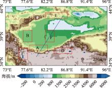
图1
塔里木盆地生态功能区及地形分布 注:底图采用国家地理信息公共服务平台标准地图制作,审图号为GS(2024)0650,对底图边界无修改。A、B分别为昆仑山北坡和南疆西部绿洲区,C、D和E分别为帕米尔高原、昆仑山和天山山区,F为塔克拉玛干沙漠区。下同。"

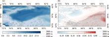
图2
1979—2022年塔里木盆地夏季平均整层大气水汽含量(a,阴影,单位:kg·m-2)及其变化趋势(b,阴影,单位:kg·m-2·(10a)-1)分布 注:(b)中黑色点代表通过显著性检验P>0.05的区域。"

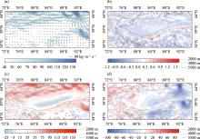
图3
1979—2022年塔里木盆地夏季平均整层水汽通量(a,矢量,单位:kg·m-1·s-1,阴影>40 kg·m-1·s-1)、水汽通量散度(b,单位:10-5 g·m-1·s-1)、整层纬向水汽通量(c,单位:kg·m-1·s-1)和整层经向水汽通量(d,单位:kg·m-1·s-1)分布"

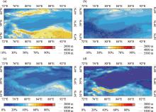
图4
1979—2022年塔里木盆地夏季平均总云量(a)、高云量(b)、中云量(c)和低云量(d)分布"

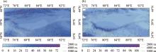
图5
1979—2022年塔里木盆地夏季平均整层云冰水含量(a,单位:g·m-2)和云液水含量(b,单位:g·m-2)分布"

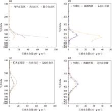
图6
1979—2022年塔里木盆地夏季高山(a、c)、沙漠和绿洲(b、d)区云液水含量和云冰水含量垂直分布 注:各生态代表区为图1红色矩形区域。"

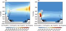
图7
1979—2022年夏季沿图1蓝色实线的云冰水含量(单位:10-1g·m-2)和水汽通量散度(单位:10-5 g·m-1·s-1)(a)、云液水含量(单位:10-1g·m-2)和水汽通量散度(单位:10-5 g·m-1·s-1)(b)垂直剖面图 注:图中灰色阴影为地形高度。"

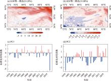
图8
1979—2022年塔里木盆地夏季整层大气水汽输送通量EOF第一和第二模态空间模态(a、b)及对应的标准化时间系数(c、d)"

表1
1979—2022年塔里木盆地夏季整层水汽输送4种空间分布类型"
| 类型 | 个数/个 | 年份 |
|---|---|---|
| 全区偏多型 | 14 | 1982,1986,1987,1989,1992,1994,1995,1998,2004,2007,2012,2013,2020,2021 |
| 全区偏少型 | 12 | 1980,1984,1985,1988,1990,1991,1999,2000,2008,2011,2015,2018 |
| 西南多东北少型 | 12 | 1979,1981,1983,1997,2001,2002,2003,2006,2009,2010,2017,2019 |
| 西南少东北多型 | 6 | 1996,2005,2014,2016,2018,1993 |
图9
1979—2022年塔里木盆地夏季区域平均整层大气水汽含量(单位:g·m-2)和区域水汽净收入(单位:106 kg·s-1)的时间演变(a)、区域不同边界水汽收支(单位:106 kg·s-1)的时间演变(b)"

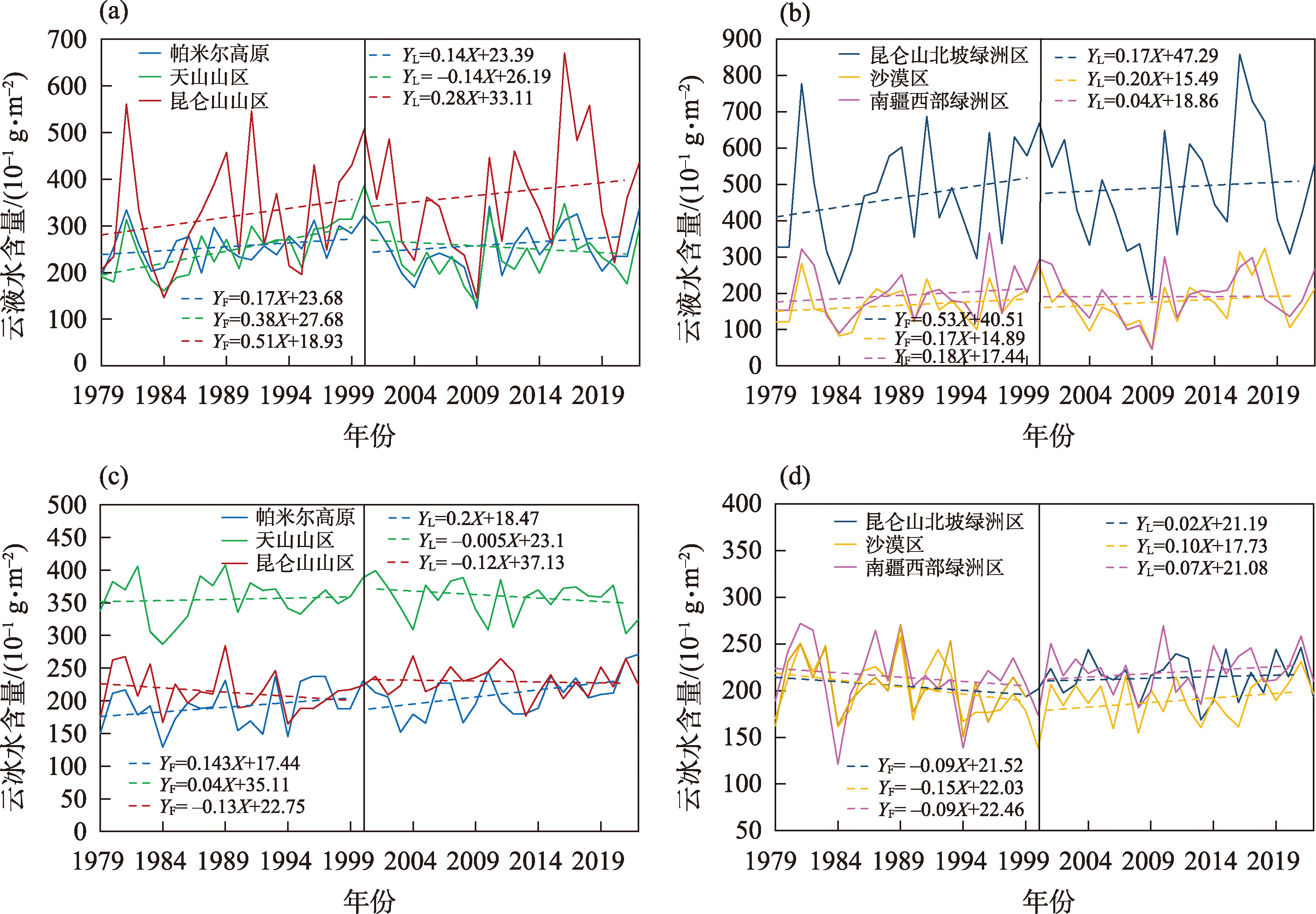
图10
1979—2022年塔里木盆地夏季高山(a、c)、绿洲和沙漠区(b、d)云液水含量和云冰水含量年际变化 注:方程下标F和L分别代表1979—2000年和2001—2022年拟合的一元线性回归方程,方程系数×10为增长率。"
| [1] | 丁贤荣. 高山增水效应及其水资源意义[J]. 山地学报, 2003, 21(6): 681-685. |
| [Ding Xianrong. Water increasing effect of mountains and its value of water resources[J]. Journal of Mountain Science, 2003, 21(6): 681-685. ] | |
| [2] | 彭宽军, 陈勇航, 林雄, 等. 利用CERES卫星遥感资料研究新疆三大山区低层云水资源[C]// 中国气象学会气候资源应用研究委员会, 国家气候中心. 第26届中国气象学会年会气候资源应用研究分会场论文集, 2009. |
| [Peng Kuanjun, Chen Yonghang, Lin Xiong, et al. CERES satellite remote sensing data were used to study the low-level cloud water resources in the three mountainous areas of Xinjiang[C]// Climate Resources Application Research Committee of Chinese Meteorological Societe, China Climate Center, the 26th Annual Meeting of the Chinese Meteorological Society, 2009. ] | |
| [3] | 张家宝, 袁玉江. 试论新疆气候对水资源的影响[J]. 自然资源学报, 2002, 17(1): 28-34. |
|
[Zhang Jiabao, Yuan Yujiang. A tentative discussion on the impact of climate on surface water resources in Xinjiang[J]. Journal of Natural Resources, 2002, 17(1): 28-34. ]
doi: 10.11849/zrzyxb.2002.01.005 |
|
| [4] | 陈勇航, 黄建平, 王天河, 等. 西北地区不同类型云的时空分布及其与降水的关系[J]. 应用气象学报, 2005, 16(6): 717-727, 862. |
| [Chen Yonghang, Huang Jianping, Wang Tianhe, et al. Temporal and spatial distribution of the different clouds over northwestern China with the relation to precipitation[J]. Journal of Applied Meteorological Science, 2005, 16(6): 717-727, 862. ] | |
| [5] | 尹宪志, 王毅荣, 徐文君, 等. 祁连山空中云水资源开发潜力研究新进展[J]. 沙漠与绿洲气象, 2020, 14(6): 134-140. |
| [Yin Xianzhi, Wang Yirong, Xu Wenjun, et al. Recent progress in research on potential for the development of cloud water resources over Qilian Mountains area[J]. Desert and Oasis Meteorology, 2020, 14(6): 134-140. ] | |
| [6] | 余杰, 蔡森, 周毓荃, 等. 2000—2019年西北地区云水资源时空特征研究[J]. 气象学报, 2024, 82(4): 476-489. |
| [Yu Jie, Cai Miao, Zhou Yuquan, et al. Spatiotemporal characteristics of cloud water resources in Northwest China from 2000 to 2019[J]. Acta Meteorologica Sinica, 2024, 82(4): 476-489. ] | |
| [7] | 李家叶, 李铁键, 王光谦, 等. 空中水资源及其降水转化分析[J]. 科学通报, 2018, 63(26): 2785-2796. |
| [Li Jiaye, Li Tiejian, Wang Guangqian, et al. Atmospheric water resource and precipitation conversion[J]. Chinese Science Bulletin, 2018, 63(26): 2785-2796. ] | |
| [8] | 黄美元. 我国人工降水亟待解决的问题和发展思路[J]. 气候与环境研究, 2011, 16(5): 543-550. |
| [Huang Meiyuan. Urgent problems and thinking of development for precipitation enhancement in China[J]. Climatic and Environmental Research, 2011, 16(5): 543-550. ] | |
| [9] |
Cai Miao, Zhou Yuquan, Liu Jianzhao, et al. Quantifying the cloud water resource: Methods based on observational diagnosis and cloud model simulation[J]. Journal of Meteorological Research, 2020, 34(6): 1256-1270.
doi: 10.1007/s13351-020-9126-6 |
| [10] |
刘菊菊, 游庆龙, 周毓荃, 等. 基于ERA-Interim的中国云水量时空分布和变化趋势[J]. 高原气象, 2018, 37(6): 1590-1604.
doi: 10.7522/j.issn.1000-0534.2018.00059 |
|
[Liu Juju, You Qinglong, Zhou Yuquan, et al. Spatiotemporal distribution and trend of cloud water content in China based on ERA-Interim reanalysis[J]. Plateau Meteorology, 2018, 37(6): 1590-1604. ]
doi: 10.7522/j.issn.1000-0534.2018.00059 |
|
| [11] | 杨大生, 王普才. 中国地区夏季6—8月云水含量的垂直分布特征[J]. 大气科学, 2012, 36(1): 89-101. |
| [Yang Dasheng, Wang Pucai. Characteristics of vertical distributions of cloud water contents over China during summer[J]. Chinese Journal of Atmospheric Sciences, 2012, 36(1): 89-101. ] | |
| [12] | 刘洪利, 朱文琴, 宜树华, 等. 中国地区云的气候特征分析[J]. 气象学报, 2003, 61(4): 466-473. |
| [Liu Hongli, Zhu Wenqin, Yi Shuhua, et al. Climatic analysis of the cloud over China[J]. Acta Meteorologica Sinica, 2003, 61(4): 466-473. ] | |
| [13] | 张沛, 姚展予, 贾烁, 等. 六盘山地区空中水资源特征及水凝物降水效率研究[J]. 大气科学, 2020, 44(2): 421-434. |
| [Zhang Pei, Yao Zhanyu, Jia Shuo, et al. Study of the characteristics of atmospheric water resources and hydrometeor precipitation efficiency over the Liupan Shan area[J]. Chinese Journal of Atmospheric Sciences, 2020, 44(2): 421-434. ] | |
| [14] | 石岩, 饶丹. 新疆水资源现状及其可持续利用对策分析[J]. 华北水利水电大学学报(自然科学版), 2015, 36(4): 36-38. |
| [Shi Yan, Rao Dan. Analysis on present situation of water resources and sustainable utilization countermeasures of Xinjiang[J]. Journal of North China University of Water Resources and Electric Power (Natural Science Edition), 2015, 36(4): 36-38. ] | |
| [15] | 陈勇航, 邓军英, 张萍, 等. 中天山附近强降水过程中云冰水含量随高度变化特征[J]. 资源科学, 2013, 35(3): 655-664. |
| [Chen Yonghang, Deng Junying, Zhang Ping, et al. Vertical distribution of ice water content in clouds during heavy rains around Tianshan Mountain[J]. Resources Science, 2013, 35(3): 655-664. ] | |
| [16] | 张小娟, 王军, 黄观, 等. 新疆3大山区云中液态水时空分布特征[J]. 干旱区研究, 2018, 35(4): 846-854. |
|
[Zhang Xiaojuan, Wang Jun, Huang Guan, et al. Spatiotemporal distribution of cloud liquid water volume over three main mountains in Xinjiang[J]. Arid Zone Research, 2018, 35(4): 846-854. ]
doi: 10.13866/j.azr.2018.04.12 |
|
| [17] | 白磊, 王维霞, 姚亚楠, 等. ERA-Interim 和NCEP/NCAR 再分析数据气温和气压值在天山山区适用性分析[J]. 沙漠与绿洲气象, 2013, 7(3): 51-56. |
| [Bai Lei, Wang Weixia, Yao Ya’nan, et al. Reliability of NCEP/NCAR and ERA-Interim reanalysis data on Tianshan Mountainous area[J]. Desert and Oasis Meteorology, 2013, 7(3): 51-56. ] | |
| [18] | 石晓兰, 杨青, 姚俊强, 等. 基于ERA-Interim资料的中国天山山区云水含量空间分布特征[J]. 沙漠与绿洲气象, 2016, 10(2): 50-56. |
| [Shi Xiaolan, Yang Qing, Yao Junqiang, et al. The spatial distribution of water vapor and cloud water content over Tianshan Mountains, China based on ERA-Interim dataset[J]. Desert and Oasis Meteorology, 2016, 10(2): 50-56. ] | |
| [19] | Liu Jin, Liang Hong, Yang Lianmei. Comparative analysis of precipitable water vapor data in the Tarim Basin, China[J]. Advances in Space Research, 2024, 74(7): 2846-2858. |
| [20] | Zeng Yong, Yang Lianmei, Tong Zepeng, et al. Seasonal variation in total cloud cover and cloud type characteristics in Xinjiang, China based on FY-4A[J]. Remote Sensing, 2024, 16(15): 2803. |
| [21] | 郝小红, 宋敏红, 周梓萱. 夏季青藏高原空中云水资源的时空特征分析[J]. 高原气象, 2020, 39(6): 1339-1347. |
|
[Hao Xiaohong, Song Minhong, Zhou Zixuan. Temporal and spatial characteristics of water vapor and cloud water over the Qinghai-Xizang Plateau in summer[J]. Plateau Meteorology, 2020, 39(6): 1339-1347. ]
doi: 10.7522/j.issn.1000-0534.2019.00135 |
|
| [22] | Sun Bo, Zhu Yali, Wang Huijun. The recent interdecadal and interannual variation of water vapor transport over Eastern China[J]. Advances in Atmospheric Sciences, 2011, 28(5): 1039-1048. |
| [23] |
刘晶, 刘兆旭, 杨莲梅, 等. 塔里木盆地及其周边地区大气可降水量分布及其与降水关系的研究[J]. 高原气象, 2024, 43(3): 617-634.
doi: 10.7522/j.issn.1000-0534.2023.00083 |
|
[Liu Jing, Liu Zhaoxu, Yang Lianmei, et al. The characteristics of atmospheric precipitable water vapor distribution and its relationship with precipitation over Tarim Basin and its surrounding area[J]. Plateau Meteorology, 2024, 43(3): 617-634. ]
doi: 10.7522/j.issn.1000-0534.2023.00083 |
|
| [24] | 王凯, 孙美平, 巩宁刚. 西北地区大气水汽含量时空分布及其输送研究[J]. 干旱区地理, 2018, 41(2): 290-297. |
| [Wang Kai, Sun Meiping, Gong Ninggang. Spatial and temporal distribution and transportation of the water vapor in the northwestern China[J]. Arid Land Geography, 2018, 41(2): 290-297. ] | |
| [25] | Huang Wei, Feng Song, Chen Jianhui, et al. Physical mechanisms of summer precipitation variations in the Tarim Basin in Northwestern China[J]. Journal of Climate, 2015, 28(9): 3579-3591. |
| [26] | Zhao Yong, Huang Anning, Zhou Yang, et al. Impact of the middle and upper tropospheric cooling over Central Asia on the summer rainfall in the Tarim Basin, China[J]. Journal of Climate, 2014, 27(12): 4721-4732. |
| [27] |
李帅, 陈勇航, 侯小刚, 等. FY-2F云量产品在新疆区域的评估及检验[J]. 干旱区研究, 2021, 38(4): 1031-1039.
doi: 10.13866/j.azr.2021.04.14 |
|
[Li Shuai, Chen Yonghang, Hou Xiaogang, et al. Evaluation of FY-2F satellite cloud products in Xinjiang[J]. Arid Zone Research, 2021, 38(4): 1031-1039. ]
doi: 10.13866/j.azr.2021.04.14 |
|
| [28] | 张强, 杨金虎, 王朋岭, 等. 西北地区气候暖湿化的研究进展与展望[J]. 科学通报, 2023, 68(14): 1814-1828. |
| [Zhang Qiang. Yang Jinhu, Wang Pengling, et al. Progress and prospect on climate warming and humidification in Northwest China[J]. Chinese Science Bulletin, 2023, 68(14): 1814-1828. ] | |
| [29] |
丁一汇, 柳艳菊, 徐影, 等. 全球气候变化的区域响应: 中国西北地区气候“暖湿化”趋势、成因及预估研究进展与展望[J]. 地球科学进展, 2023, 38(6): 551-562.
doi: 10.11867/j.issn.1001-8166.2023.027 |
|
[Ding Yihui, Liu Yanju, Xu Ying, et al. Regional responses to global climate change: Progress and prospects for trend, causes, and projection of climatic warming-wetting in Northwest China[J]. Advances in Earth Science, 2023, 38(6): 551-562. ]
doi: 10.11867/j.issn.1001-8166.2023.027 |
|
| [30] |
张红丽, 韩富强, 张良, 等. 西北地区气候暖湿化空间与季节差异分析[J]. 干旱区研究, 2023, 40(4): 517-531.
doi: 10.13866/j.azr.2023.04.01 |
|
[Zhang Hongli, Han Fuqiang, Zhang Liang, et al. Analysis of spatial and seasonal variations in climate warming and humidification in Northwest China[J]. Arid Zone Research, 2023, 40(4): 517-531. ]
doi: 10.13866/j.azr.2023.04.01 |
|
| [31] |
张强, 杨金虎, 马鹏里, 等. 西北地区气候暖湿化增强东扩特征及其形成机制与重要环境影响[J]. 干旱气象, 2023, 41(3): 351-358.
doi: 10.11755/j.issn.1006-7639(2023)-03-0351 |
| [Zhang Qiang, Yang Jinhu, Ma Pengli, et al. The enhancement and eastward expansion of climate warming and humidification, formation mechanism and important environmental impacts in Northwest China[J]. Journal of Arid Meteorology, 2023, 41(3): 351-358. ] | |
| [32] | 王瑞英, 周文韬, 任丹阳, 等. 基于ERA5资料的陕西地区云水资源评估[J]. 陕西气象, 2023(6): 10-16. |
| [Wang Ruiying, Zhou Wentao, Ren Danyang, et al. Assessment of cloud water resources in Shaanxi Province based on ERA5 data[J]. Journal of Shaanxi Meteorology, 2023(6): 10-16. ] | |
| [33] |
张玉欣, 马学谦, 韩辉邦, 等. 2014—2018年青海省云水资源时空分布特征[J]. 干旱区研究, 2021, 38(5): 1254-1262.
doi: 10.13866/j.azr.2021.05.07 |
|
[Zhang Yuxin, Ma Xueqian, Han Huibang, et al. Analysis of spatial and temporal distribution characteristics of cloud water resources in Qinghai Province from 2014 to 2018[J]. Arid Zone Research, 2021, 38(5): 1254-1262. ]
doi: 10.13866/j.azr.2021.05.07 |
|
| [34] |
把黎, 尹宪志, 庞朝云, 等. 祁连山地区夏季南坡与北坡空中云水资源差异性分析[J]. 干旱区研究, 2022, 39(5): 1345-1359.
doi: 10.13866/j.azr.2022.05.02 |
|
[Ba Li, Yin Xianzhi, Pang Zhaoyun, et al. Characteristics of the difference in air water resources between the north and south slopes of the Qilian Mountains in the summer[J]. Arid Zone Research, 2022, 39(5): 1345-1359. ]
doi: 10.13866/j.azr.2022.05.02 |
| [1] | 文迪, 吕爱锋, 李涛辉, 张文翔. 塔里木盆地农业光热资源特征及开发潜力分析[J]. 干旱区研究, 2025, 42(2): 384-396. |
| [2] | 田文君, 薛一波, 张小啸, 雷加强, 李生宇, 范敬龙, 张恒. 2021年春季塔里木盆地典型沙尘天气过程气溶胶垂直分布及传输[J]. 干旱区研究, 2025, 42(1): 14-26. |
| [3] | 王婷, 沈赣华, 刘兵, 孙莹琳, 汪再光. 天山北坡经济带水库群时空变化特征及驱动机制[J]. 干旱区研究, 2024, 41(9): 1456-1467. |
| [4] | 龙威夷, 施建飞, 李双媛, 孙金金, 王玉刚. 流域绿洲土壤盐分多模型反演效果评估[J]. 干旱区研究, 2024, 41(7): 1120-1130. |
| [5] | 程秋连, 刘杰, 杨治纬, 张天意, 王斌. 独库高速阿尔先沟段雪崩空间分布及因子探测[J]. 干旱区研究, 2024, 41(2): 220-229. |
| [6] | 朱从祯,赵天良,孟露,杨兴华,何清,买买提艾力·买买提依明. 塔里木盆地浮尘滞空天气客观分型[J]. 干旱区研究, 2023, 40(9): 1391-1403. |
| [7] | 赵美亮, 曹广超, 赵青林, 曹生奎. 气候及土地利用变化对大通河源区水文要素空间分布的影响[J]. 干旱区研究, 2023, 40(3): 381-391. |
| [8] | 程红霞, 林粤江, 陈鹏, 梁凤超, 王勇. 塔里木盆地沙尘天气日数变化及影响因素[J]. 干旱区研究, 2023, 40(11): 1707-1717. |
| [9] | 徐俏,赵万羽,魏岩,叶茂,赵新风. 阿尔泰山东部林区森林种群结构和空间分布格局[J]. 干旱区研究, 2022, 39(6): 1885-1895. |
| [10] | 高洁,赵勇,姚俊强,迪丽努尔·托列吾别克,王梦园. 气候变化背景下中亚干旱区大气水分循环要素时空演变[J]. 干旱区研究, 2022, 39(5): 1371-1384. |
| [11] | 李泽厚,李蕊希,张舒斌,王崇斌,郑明明,董叶卿,吴雪. 多枝柽柳叶片结构和化学性状对土壤水分变化的响应[J]. 干旱区研究, 2022, 39(5): 1486-1495. |
| [12] | 胡长通,杨涛,万旭昊,孙来康,郑奕文,严雪溶. 西安市河流沉积物重金属分布特征及其与土地利用类型关系[J]. 干旱区研究, 2022, 39(4): 1270-1281. |
| [13] | 王佳文,彭杰,纪文君,白建铎,冯春晖,李洪义. 基于电磁感应数据的南疆棉田土壤pH反演研究[J]. 干旱区研究, 2022, 39(4): 1293-1302. |
| [14] | 孙从建,陈伟,王诗语. 气候变化下的塔里木盆地西南部内陆河流域径流组分特征分析[J]. 干旱区研究, 2022, 39(1): 113-122. |
| [15] | 刘鑫,焦健,王婷,张玲豫,李朝周. 巴丹吉林沙漠南缘沙地芦苇种群生态特征[J]. 干旱区研究, 2022, 39(1): 220-229. |
|
||