干旱区研究 ›› 2022, Vol. 39 ›› Issue (4): 1270-1281.doi: 10.13866/j.azr.2022.04.27
胡长通1( ),杨涛1,2(),万旭昊1,孙来康1,郑奕文1,严雪溶1
收稿日期:2021-11-24
修回日期:2022-02-26
出版日期:2022-07-15
发布日期:2022-09-26
通讯作者:
杨涛
作者简介:胡长通(1996-),男,硕士研究生,研究方向为流域生态健康评价. E-mail: 基金资助:
HU Changtong1(),YANG Tao1,2(),WAN Xuhao1,SUN Laikang1,ZHENG Yiwen1,YAN Xuerong1
Received:2021-11-24
Revised:2022-02-26
Online:2022-07-15
Published:2022-09-26
Contact:
Tao YANG
摘要:
为了解不同土地利用类型对河流沉积物重金属分布影响,以西安典型城市河流(灞河、浐河、沣河和黑河)为研究对象,采用潜在生态风险法(RI)、污染负荷指数法(PLI)、相关性分析与主成分分析等方法对河流沉积物重金属(Cr、Mn、Ni、Cu、Zn、Cd和As)的空间分布、环境风险以及来源进行分析和评价。结果表明:4条河流沉积物重金属含量大小为:浐河>灞河>黑河>沣河;相关性分析表明,河岸小范围内林地与草地对于重金属富集作用更强;RI结果表明,Cd对于污染贡献最大,4条河流均处于中等潜在生态风险;PLI结果表明,黑河H1样点受到污染程度最高,为中度污染;RI与PLI评价均表明,浐河样点受污染占比最大,且集中在人造地占比与人类活动强度较大的中下游;相关性分析与主成分分析表明,大部分重金属来源于工业与农业生产排放以及交通污染等人类活动。为防止污染进一步加深,应特别注意Cd污染的防治,特别是沣河中游与黑河中游。
胡长通,杨涛,万旭昊,孙来康,郑奕文,严雪溶. 西安市河流沉积物重金属分布特征及其与土地利用类型关系[J]. 干旱区研究, 2022, 39(4): 1270-1281.
HU Changtong,YANG Tao,WAN Xuhao,SUN Laikang,ZHENG Yiwen,YAN Xuerong. Distribution characteristics of heavy metals in river sediments and their relationship with land use types in Xi’an City[J]. Arid Zone Research, 2022, 39(4): 1270-1281.
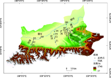
图1
采样点分布示意图"

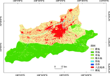
图2
西安市土地利用类型分布"

表1
单项潜在生态风险指数(Er)和潜在生态风险指数(RI)分级标准"
| Er | 生态风险 | RI | 生态风险 |
|---|---|---|---|
| Er<40 | 低 | RI<150 | 低 |
| 40≤Er<80 | 轻度 | 150≤RI<300 | 轻度 |
| 80≤Er<160 | 中度 | 300≤RI<600 | 中度 |
| 160≤Er<320 | 高 | RI≥600 | 高 |
| Er≥320 | 非常高 | - | - |

图3
土地利用类型面积占比和人类活动强度指数"
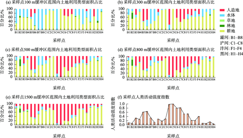
表2
西安市河流沉积物重金属浓度"
| 样品数量 | Cr | Mn | Ni | Cu | Zn | Cd | As | ||
|---|---|---|---|---|---|---|---|---|---|
| 西安市河流 | 24 | 平均 | 45.53 | 810.60 | 33.07 | 32.01 | 88.33 | 0.44 | 6.31 |
| Cv/% | 75.81 | 42.53 | 71.56 | 56.53 | 39.84 | 140.75 | 53.25 | ||
| 灞河 | 8 | 平均 | 19.94 | 767.92 | 39.88 | 27.77 | 93.19 | 0.49 | 5.78 |
| Cv/% | 105.25 | 39.89 | 84.53 | 30.76 | 26.70 | 144.98 | 46.63 | ||
| 浐河 | 8 | 平均 | 44.73 | 1007.71 | 28.02 | 34.38 | 102.69 | 0.44 | 6.73 |
| Cv/% | 39.71 | 28.48 | 13.44 | 31.51 | 40.59 | 91.22 | 23.08 | ||
| 沣河 | 4 | 平均 | 49.25 | 601.46 | 20.33 | 25.00 | 79.71 | 0.46 | 4.88 |
| Cv/% | 28.74 | 27.88 | 47.73 | 58.43 | 32.76 | 144.43 | 30.62 | ||
| 黑河 | 4 | 平均 | 94.58 | 710.92 | 42.29 | 42.75 | 58.54 | 0.42 | 7.97 |
| Cv/% | 43.64 | 62.5 | 56.69 | 79.61 | 42.37 | 143.03 | 79.79 | ||
| 背景值 | 62.50 | 557.00 | 28.80 | 25.90 | 73.00 | 0.094 | 11.10 |
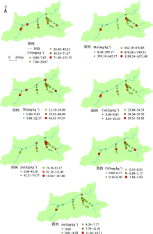
图4
河流沉积物重金属含量分布"
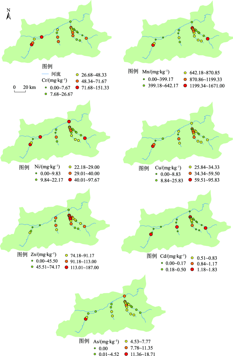
表3
灞河与浐河沉积物重金属与土地利用类型以及人类活动强度相关性"
| 范围 | Cr | Mn | Ni | Cu | Zn | Cd | As |
|---|---|---|---|---|---|---|---|
| 100 m | 林地-0.69** | 林地-0.55* | 林地-0.68** | 林地-0.50* | - | - | 林地-0.66** |
| - | - | - | - | - | - | 草地-0.80** | |
| 300 m | 林地-0.55* | 草地-0.50* | 林地-0.54* | 林地-0.52* | |||
| 草地-0.55* | - | - | - | - | - | - | |
| 500 m | 林地-0.54* | 林地-0.62** | - | - | - | - | - |
| 草地-0.53* | 草地-0.51* | - | - | - | - | - | |
| 800 m | 林地-0.50* | 林地-0.54* | - | - | - | - | - |
| 1500 m | 林地-0.51* | 林地-0.51* | - | - | - | - | - |
| 河岸带人类活动强度指数 | 0.72** | 0.83** | 0.72** | 0.51* | - | 0.62* | 0.72** |
表4
河流沉积物重金属单项潜在生态风险指数(Er)和潜在生态风险指数(RI)均值"
| 河流 | Cr | Mn | Ni | Cu | Zn | Cd | As | RI |
|---|---|---|---|---|---|---|---|---|
| 灞河 | 0.64 | 1.38 | 6.92 | 5.36 | 1.28 | 139.63 | 5.20 | 160.41 |
| 浐河 | 1.43 | 1.81 | 4.86 | 6.64 | 1.41 | 139.63 | 6.07 | 161.84 |
| 沣河 | 1.58 | 1.08 | 3.53 | 4.83 | 1.09 | 146.28 | 4.40 | 162.78 |
| 黑河 | 3.03 | 1.28 | 7.34 | 8.25 | 0.80 | 132.98 | 7.18 | 160.86 |
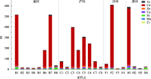
图5
沉积物重金属潜在生态风险指数(RI)"


图6
污染负荷指数(PLI)"

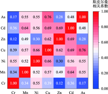
图7
重金属相关性分析热图"

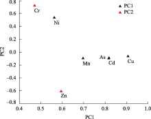
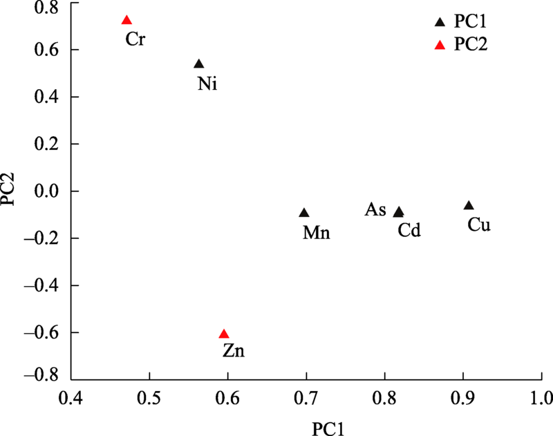
图8
沉积物重金属主成分载荷图"
| [1] |
Fan S. Assessment of heavy metal pollution in stream sediments for the Baoji City section of the Weihe River in Northwest China[J]. Water Science and Technology, 2014, 70(7): 1279-1284.
doi: 10.2166/wst.2014.366 |
| [2] | 王若锦, 邵天杰, 卫佩茹. 环青海湖地区表层土壤重金属富集含量及其生态风险评价[J]. 干旱区研究, 2021, 38(2): 411-420. |
| [Wang Ruojin, Shao Tianjie, Wei Peiru. Enrichment content and ecological risk assessment of heavy metal in surface soil around Qinghai Lake[J]. Arid Zone Research, 2021, 38(2): 411-420.] | |
| [3] |
Ustaoğlu F, Islam M S. Potential toxic elements in sediment of some rivers at Giresun, Northeast Turkey: A preliminary assessment for ecotoxicological status and health risk[J]. Ecological Indicators, 2020, 113: 106237.
doi: 10.1016/j.ecolind.2020.106237 |
| [4] |
Xiao H, Shahab A, Xi B, et al. Heavy metal pollution, ecological risk, spatial distribution, and source identification in sediments of the Lijiang River, China[J]. Environmental Pollution, 2021, 269: 116189.
doi: 10.1016/j.envpol.2020.116189 |
| [5] | 任惠丽, 田强兵, 丁妍, 等. 渭河陕西段鱼体肌肉中重金属污染研究[J]. 环境科学与技术, 2014, 37(12): 134-137. |
| [Ren Huili, Tian Qiangbing, Ding Yan, et al. Analysis of heavy metal contained in fishes’muscle in Shaanxi section of Weihe River[J]. Environmental Science and Technology, 2014, 37(12): 134-137.] | |
| [6] |
Bing H, Wu Y, Liu E, et al. Assessment of heavy metal enrichment and its human impact in lacustrine sediments from four lakes in the mid-low reaches of the Yangtze River, China[J]. Journal of Environmental Sciences, 2013, 25(7): 1300-1309.
doi: 10.1016/S1001-0742(12)60195-8 |
| [7] |
Liu B Q, Xu M, Wang J, et al. Ecological risk assessment and heavy metal contamination in the surface sediments of Haizhou Bay, China[J]. Marine Pollution Bulletin, 2021, 163: 111954.
doi: 10.1016/j.marpolbul.2020.111954 |
| [8] |
Yang J, Cao L L, Wang J H, et al. Speciation of metals and assessment of contamination in surface sediments from Daya bay, south China sea[J]. Sustainability, 2014, 6(12): 9096-9113.
doi: 10.3390/su6129096 |
| [9] |
Li R, Tang X Q, Guo W J, et al. Spatiotemporal distribution dynamics of heavy metals in water, sediment, and zoobenthos in mainstream sections of the middle and lower Changjiang River[J]. Science of the Total Environment, 2020, 714(1): 136779.
doi: 10.1016/j.scitotenv.2020.136779 |
| [10] |
Mrozinska N, Bakowska M. Effects of heavy metals in lake water and sediments on bottom invertebrates inhabiting the brackish coastal lake Lebsko on the southern Baltic coast[J]. International Journal of Environmental Research and Public Health, 2020, 17(18): 6848.
doi: 10.3390/ijerph17186848 |
| [11] |
Fan H M, Chen S S, Li Z E, et al. Assessment of heavy metals in water, sediment and shellfish organisms in typical areas of the Yangtze River Estuary, China[J]. Marine Pollution Bulletin, 2020, 151: 110864.
doi: 10.1016/j.marpolbul.2019.110864 |
| [12] |
Liu X P, Jiang J Y, Yan Y, et al. Distribution and risk assessment of metals in water, sediments, and wild fish from Jinjiang River in Chengdu, China[J]. Chemosphere, 2018, 196: 45-52.
doi: 10.1016/j.chemosphere.2017.12.135 |
| [13] | Tang W Z, Sun L, Shu L M, et al. Evaluating heavy metal contamination of riverine sediment cores in different land-use areas[J]. Frontiers of Environmental Science & Engineering, 2020, 14(6): 141-151. |
| [14] |
Mohammadi M, Khaledi Darvishan A, Dinelli E, et al. How does land use configuration influence on sediment heavy metal pollution? Comparison between riparian zone and sub-watersheds[J]. Stochastic Environmental Research and Risk Assessment, 2021, 35: 1-16.
doi: 10.1007/s00477-020-01927-5 |
| [15] |
Nsenga Kumwimba M, Zhu B, Wang T, et al. Distribution and risk assessment of metals and arsenic contamination in man-made ditch sediments with different land use types[J]. Environmental Science and Pollution Research, 2016, 23(24): 24808-24823.
doi: 10.1007/s11356-016-7690-1 |
| [16] |
Wang F, Dong W Y, Zhao Z L, et al. Spatial and vertical distribution, composition profiles, sources, and ecological risk assessment of polycyclic aromatic hydrocarbon residues in the sediments of an urban tributary: A case study of the Songgang River, Shenzhen, China[J]. Environmental Pollution, 2020, 266: 115360.
doi: 10.1016/j.envpol.2020.115360 |
| [17] |
Wang L, Zhang J, Li H L, et al. Shift in the microbial community composition of surface water and sediment along an urban river[J]. Science of The Total Environment, 2018, 627: 600-612.
doi: 10.1016/j.scitotenv.2018.01.203 |
| [18] | 王洪涛, 张俊华, 丁少峰, 等. 开封城市河流表层沉积物重金属分布、污染来源及风险评估[J]. 环境科学学报, 2016, 36(12): 4520-4530. |
| [Wang Hongtao, Zhang Junhua, Ding Shaofeng, et al. Distribution characteristics, sources identification and risk assessment of heavy metals in surface sediments of urban rivers in Kaifeng[J]. Acta Scientiae Circumstantiae, 2016, 36(12): 4520-4530.] | |
| [19] |
Zeng Y S, Bi C J, Jia J P, et al. Impact of intensive land use on heavy metal concentrations and ecological risks in an urbanized river network of Shanghai[J]. Ecological Indicators, 2020, 116: 106501.
doi: 10.1016/j.ecolind.2020.106501 |
| [20] |
Viana L F, Kummrow F, Cardoso CAL, et al. High concentrations of metals in the waters from Araguari River lower section (Amazon biome): Relationship with land use and cover, ecotoxicological effects and risks to aquatic biota[J]. Chemosphere, 2021, 285: 131451.
doi: 10.1016/j.chemosphere.2021.131451 |
| [21] |
Wang F, Dong W Y, Zhao Z L, et al. Heavy metal pollution in urban river sediment of different urban functional areas and its influence on microbial community structure[J]. Science of The Total Environment, 2021, 778: 146383.
doi: 10.1016/j.scitotenv.2021.146383 |
| [22] | 孙定, 董兴国, 景红军, 等. 西安新型都市渔业发展思路探讨[J]. 安徽农学通报, 2019, 25(13): 101-103. |
| [Sun Ding, Dong Xingguo, Jing Hongjun, et al. Discusion on the development ideas of the new-type urban modern fishery in Xi’an city[J]. Anhui Agricultural Science Bulletin, 2019, 25(13): 101-103 ] | |
| [23] | 蒋建军, 冯普林. 秦岭北麓水资源利用现状与生态景观维护[J]. 人民黄河, 2010, 32(7): 68-70. |
| [Jiang Jianjun, Feng Pulin. Present status of water resources utilization and maintenance of ecological landscape of the northern foot of Qinling Mountain[J]. Yellow River, 2010, 32(7): 68-70.] | |
| [24] | 郭威, 李祥忠, 刘卫国. 西安周边河流溶解无机碳浓度及同位素组成初探[J]. 环境科学, 2013, 34(4): 1291-1297. |
| [Guo Wei, Li Xiangzhong, Liu Weiguo. Study on the content and carbon isotopic composition of water dissolved inorganic carbon from rivers around Xi’an City[J]. Environmental Science, 2013, 34(4): 1291-1297.] | |
| [25] | 孙大鹏. 西安市周边河流水质变化趋势的分析研究[J]. 水资源与水工程学报, 2007, 18(1): 76-78. |
| [Sun Dapeng. Analysis of changing trend of the water quality around Xi’an[J]. Journal of Water Resources & Water Engineering, 2007, 18(1): 76-78.] | |
| [26] |
Wan X H, Yang T, Zhang Q, et al. A novel comprehensive model of set pair analysis with extenics for river health evaluation and prediction of semi-arid basin: A case study of Wei River Basin, China[J]. The Science of the Total Environment, 2021, 775: 145845.
doi: 10.1016/j.scitotenv.2021.145845 |
| [27] |
Wan X H, Yang T, Zhang Q, et al. Joint effects of habitat indexes and physic-chemical factors for freshwater basin of semi-arid area on plankton integrity: A case study of the Wei River Basin, China[J]. Ecological Indicators, 2021, 120: 106909.
doi: 10.1016/j.ecolind.2020.106909 |
| [28] |
Håkanson L. An ecological risk index for aquatic pollution control: A sedimentological approach[J]. Water Research, 1980, 14: 975-1001.
doi: 10.1016/0043-1354(80)90143-8 |
| [29] |
Hilton J, Davison W, Ochsenbein U. A mathematical model for analysis of sediment core data: Implications for enrichment factor calculations and trace-metal transport mechanisms[J]. Chemical Geology, 1985, 48: 281-291.
doi: 10.1016/0009-2541(85)90053-1 |
| [30] |
Tomlinson D L, Wilson J G, Harris C R, et al. Problems in the assessment of heavy-metal levels in estuaries and the formation of a pollution index[J]. Helgoländer Meeresuntersuchungen, 1980, 33(1-4): 566-575.
doi: 10.1007/BF02414780 |
| [31] |
Liu J, Peng A G, Deng S, et al. Distribution of heavy metals and radionuclides in the sediments and their environmental impacts in Nansha Sea area, South China Sea[J]. Marine Pollution Bulletin, 2021, 166: 112192.
doi: 10.1016/j.marpolbul.2021.112192 |
| [32] | 王勤, 彭渤, 方小红, 等. 湘江长沙段沉积物重金属污染特征及其评价[J]. 环境化学, 2020, 39(4): 999-1011. |
| [Wang Qin, Peng Bo, Fang Xiaohong, et al. Characteristics and assessment of heavy metal contamination in sediments from Changsha section of the Xiangjiang River, Hunan Province of China[J]. Environmental Chemistry, 2020, 39(4): 999-1011.] | |
| [33] | 马玉, 李团结, 高全洲, 等. 珠江口沉积物重金属背景值及其污染研究[J]. 环境科学学报, 2014, 34(3): 712-719. |
| [Ma Yu, Li Tuanjie, Gao Quanzhou, et al. Background values and contamination of heavy metals in sediments from the Pearl River Estuary[J]. Acta Scientiae Circumstantiae, 2014, 34(3): 712-719.] | |
| [34] | 李欢娟, 李会霞, 史兴民. 西安市主要湖泊表层沉积物重金属污染及生态风险评估[J]. 干旱区资源与环境, 2019, 33(2): 122-126. |
| [Li Huanjuan, Li Huixia, Shi Xingmin. Pollution characteristics of heavy metals and ecological risk assessment for thesurface sediments of the lakes in Xi’an[J]. Journal of Arid Land Resources and Environment, 2019, 33(2): 122-126.] | |
| [35] | 徐双贵, 杨莎, 秦西伟, 等. 湟水河流域西宁段河流表层沉积物重金属空间分布及生态风险评估[J]. 地球与环境, 2021, 49(5): 561-569. |
| [Xu Shuanggui, Yang Sha, Qin Xiwei, et al. Spatial distribution and ecological risk assessment of heavy metals in surface sediments from Xining section of the Huangshui River Basin[J]. Earth and Environment, 2021, 49(5): 561-569.] | |
| [36] | 温泉, 赵艳民, 曹伟, 等. 潮白河中游沉积物中重金属分布、来源及生态风险评估[J]. 环境科学研究, 2020, 33(3): 599-607. |
| [Wen Quan, Zhao Yanmin, Cao Wei, et al. Distribution characteristics, source and potential ecological risk of heavy metals pollution in the middle reaches of Chaobai River[J]. Research of Environmental Sciences, 2020, 33(3): 599-607.] | |
| [37] | 宁增平, 蓝小龙, 黄正玉, 等. 贺江水系沉积物重金属空间分布特征、来源及潜在生态风险[J]. 中国环境科学, 2017, 37(8): 3036-3047. |
| [Ning Zengping, Lan Xiaolong, Huang Zhengyu, et al. Spatial distribution characteristics, sources and potential ecological risk of heavy metals in sediments of the Hejiang River[J]. China Environmental Science, 2017, 37(8): 3036-3047.] | |
| [38] | 杨安, 邢文聪, 王小霞, 等. 西藏中部河流、湖泊表层沉积物及其周边土壤重金属来源解析及风险评价[J]. 中国环境科学, 2020, 40(10): 4557-4567. |
| [Yang An, Xing Wencong, Wang Xiaoxia, et al. Source and risk assessment of heavy metals in surface sediments of rivers, lakes and their surrounding soils in central Tibet[J]. China Environmental Science, 2020, 40(10): 4557-4567.] | |
| [39] | 孙恬, 王延华, 叶春, 等. 太湖北部小流域沉积物重金属污染特征与评价[J]. 中国环境科学, 2020, 40(5): 2196-2203. |
| [Sun Tian, Wang Yanhua, Ye Chun, et al. Characteristics and assessment of heavy metals pollution in the sediments from a small catchment in northern Taihu Basin[J]. China Environmental Science, 2020, 40(5): 2196-2203.] | |
| [40] |
Li M Y, Zhang Q G, Sun X J, et al. Heavy metals in surface sediments in the trans-Himalayan Koshi River catchment: Distribution, source identification and pollution assessment[J]. Chemosphere, 2020, 244: 125410.
doi: 10.1016/j.chemosphere.2019.125410 |
| [41] |
李玄添, 张风宝, 杨明义. 渭河陕西段沉积物重金属空间分布及来源解析[J]. 应用生态学报, 2020, 31(12): 4225-4234.
doi: 10.13287/j.1001-9332.202012.035 |
|
[Li Xuantian, Zhang Fengbao. Yang Mingyi. Spatial variation and source identification of heavy metals in sediments in Shaanxi section of Weihe River, Northwest China[J]. Chinese Journal of Applied Ecology, 2020, 31(12): 4225-4234.]
doi: 10.13287/j.1001-9332.202012.035 |
|
| [42] | 李晋鹏, 成登苗, 赵爱东, 等. 澜沧江梯级水坝库区沉积物重金属和营养盐污染特征及评价[J]. 环境科学学报, 2019, 39(8): 2791-2799. |
| [Li Jinpeng, Cheng Dengmiao, Zhao Aidong, et al. The characteristics and the assessment of heavy metal and nutrient pollution in sediments of cascading hydropower dams in Lancang River[J]. Acta Scientiae Circumstantiae, 2019, 39(8): 2791-2799.] | |
| [43] |
Miranda L, Deilami K, Ayoko G, et al. Influence of land use class and configuration on water-sediment partitioning of heavy metals[J]. Science of The Total Environment, 2021, 804: 150116.
doi: 10.1016/j.scitotenv.2021.150116 |
| [44] |
Liu A, Duodu G O, Goonetilleke A, et al. Influence of land use configurations on river sediment pollution[J]. Environmental Pollution, 2017, 229: 639-646.
doi: S0269-7491(17)31622-6 pmid: 28689152 |
| [45] |
Yang T, Chen J, Li X P, et al. Ecological risk by heavy metal contents in sediments within the Wei River Basin, China[J]. Environmental Earth Sciences, 2019, 78(3) : 1-12.
doi: 10.1007/s12665-018-7995-0 |
| [46] |
Tian K, Wu Q M, Liu P, et al. Ecological risk assessment of heavy metals in sediments and water from the coastal areas of the Bohai Sea and the Yellow Sea[J]. Environment International, 2020, 136: 105512.
doi: 10.1016/j.envint.2020.105512 |
| [47] |
Fu J, Zhao C P, Luo Y P, et al. Heavy metals in surface sediments of the Jialu River, China: Their relations to environmental factors[J]. Journal of Hazard Mater, 2014, 270: 102-109.
doi: 10.1016/j.jhazmat.2014.01.044 |
| [48] | 杨颖, 孙文, 刘吉宝, 等. 北运河流域沙河水库沉积物重金属分布及生态风险评估[J]. 环境科学学报, 2021, 41(1): 217-227. |
| [Yang Ying, Sun Wen, Liu Jibao, et al. Distribution and ecological risk assessment of heavy metals in sediments of Shahe reservoir in northern Canal Basin[J]. Acta Scientiae Circumstantiae, 2021, 41(1): 217-227.] | |
| [49] | 杨阳, 周正朝, 张福平, 等. 沣河沿岸土壤重金属分布特征及来源分析[J]. 干旱区研究, 2014, 31(2): 237-243. |
| [Zhou Zhengchao, Zhang Fuping, et al. Spatial distribution and sources of heavy metals in soil samples collected from the riparian area of the Fenghe River[J]. Arid Zone Research, 2014, 31(2): 237-243.] | |
| [50] |
张義, 于一雷, 李胜男, 等. 潮河沉积物重金属污染特征及生态风险评价[J]. 环境科学与技术, 2020, 43(7): 169-179.
doi: 10.1021/es801359d |
|
[Zhang Yi, Yu Yilei, Li Shengnan, et al. Characteristics and ecological risk assessment of heavy metal in sediments of Chao River, North China[J]. Environmental Science & Technology, 2020, 43(7): 169-179.]
doi: 10.1021/es801359d |
|
| [51] | Yang T, Li X P, Xu Y F, et al. Potentinal ecological risk and contamination of heavy metals in Feng River, China[J]. Fresenius Environmental Bulletin, 2017, 26(6): 4039-4046. |
| [52] | 孙芹芹, 姬厚德, 赵东波, 等. 闽江下游土地利用格局对河流沉积物中重金属含量的影响[J]. 海洋湖沼通报, 2020(3): 113-119. |
| [Sun Qinqin, Ji Houde, Zhao Dongbo, et al. The impact of land use patterns on heavy metals contents in sediments of the Minjiang lower reaches[J]. Transactions of Oceanology and Limnology, 2020(3): 113-119.] |
| [1] | 马瑶瑶, 史培军, 徐伟, 张钢锋. 干旱区水电站建设运营生态环境影响遥感监测[J]. 干旱区研究, 2023, 40(9): 1498-1508. |
| [2] | 赵美亮, 曹广超, 赵青林, 曹生奎. 气候及土地利用变化对大通河源区水文要素空间分布的影响[J]. 干旱区研究, 2023, 40(3): 381-391. |
| [3] | 徐俏,赵万羽,魏岩,叶茂,赵新风. 阿尔泰山东部林区森林种群结构和空间分布格局[J]. 干旱区研究, 2022, 39(6): 1885-1895. |
| [4] | 王佳文,彭杰,纪文君,白建铎,冯春晖,李洪义. 基于电磁感应数据的南疆棉田土壤pH反演研究[J]. 干旱区研究, 2022, 39(4): 1293-1302. |
| [5] | 刘鑫,焦健,王婷,张玲豫,李朝周. 巴丹吉林沙漠南缘沙地芦苇种群生态特征[J]. 干旱区研究, 2022, 39(1): 220-229. |
| [6] | 金梦婷,徐丽萍,徐权. 基于FLUS-Markov模型的多情景景观生态风险评价与预测——以南疆克州为例[J]. 干旱区研究, 2021, 38(6): 1793-1804. |
| [7] | 许志平,邵天杰,张连凯,邵明玉,牛俊杰. 黄土区不同土地利用类型下砂质壤土地表CO2通量变化特征——以清凉寺沟流域为例[J]. 干旱区研究, 2021, 38(4): 1000-1009. |
| [8] | 文广超,赵梅娟,谢洪波,张毅,张娟. 伊犁河谷西部土地植被覆盖演化及驱动力分析[J]. 干旱区研究, 2021, 38(3): 843-854. |
| [9] | 王若锦,邵天杰,卫佩茹. 环青海湖地区表层土壤重金属富集含量及其生态风险评价[J]. 干旱区研究, 2021, 38(2): 411-420. |
| [10] | 张建文, 李鹏, 高海东, 杨倩楠, 刘展. 覆沙坡面微地形变化与侵蚀产沙的响应关系[J]. 干旱区研究, 2020, 37(3): 757-. |
| [11] | 李浙华, 李生宇, 李丙文, 范敬龙, 蒋进, 李亚萍, 宋春武. 不同植被覆盖度沙垄土壤化学性质的空间分异[J]. 干旱区研究, 2020, 37(1): 160-167. |
| [12] | 毛丽, 苏志珠, 王国玲, 马义娟, 李想. 毛乌素沙地不同土地利用类型的土壤粒度及有机质特征[J]. 干旱区研究, 2019, 36(3): 589-598. |
| [13] | 王蓓, 赵军, 仲俊涛. 2005—2015年石羊河流域生态系统服务时空分异[J]. 干旱区研究, 2019, 36(2): 474-485. |
| [14] | 余秀秀, 张明军, 王圣杰, 邱雪, 杜铭霞, 周苏娥, 孟鸿飞. 基于LMDZ模型的西北干旱区水汽再循环率分析 [J]. 干旱区研究, 2019, 36(1): 29-43. |
| [15] | 梁书民, 于智媛. 用经验径流系数推算全球径流深度分布场[J]. 干旱区研究, 2018, 35(01): 1-11. |
|
||