干旱区研究 ›› 2025, Vol. 42 ›› Issue (2): 384-396.doi: 10.13866/j.azr.2025.02.17 cstr: 32277.14.AZR.20250217
• 农业生态 • 上一篇
文迪1( ), 吕爱锋2, 李涛辉3, 张文翔1()
收稿日期:2024-10-14
修回日期:2024-12-09
出版日期:2025-02-15
发布日期:2025-02-21
通讯作者:
张文翔. E-mail: wenxiangzhang@ynnu.edu.cn作者简介:文迪(1999-),女,硕士研究生,研究方向为气候变化及农业生态环境. E-mail: 1159673486@qq.com
基金资助:
WEN Di1(), LYU Aifeng2, LI Taohui3, ZHANG Wenxiang1()
Received:2024-10-14
Revised:2024-12-09
Published:2025-02-15
Online:2025-02-21
摘要:
农业光热资源是塔里木盆地西部大开发国家战略中核心的优势资源。然而,目前鲜见对塔里木盆地农业光热资源开发潜力进行综合定量评估。在对塔里木盆地农业光热资源时空演变特征分析的基础上,构建了综合的评价指标体系,采用熵权-TOPSIS法和Mann-Kendall检验等方法对塔里木盆地农业光热资源的开发潜力进行量化评估。结果表明:(1)1990—2020年塔里木盆地的农业光热资源中年日照时数、年太阳辐射总量、≥10 ℃活动积温和年平均气温都呈现上升趋势,而≥3 h有效日照天数和年蒸发量则呈现下降趋势。(2)塔里木盆地的农业光热资源存在显著的空间不均衡性,不同指标呈现不同的空间分异特征,形成了显著的高农业光热资源和低农业光热资源聚集分布的空间特征。(3)塔里木盆地农业光热资源开发潜力存在显著空间差异,开发潜力评分均值为0.199,最高的策勒县(0.578)是最低的柯坪县(0.094)的6倍多,形成“多核心”的分布态势。研究结果可为塔里木盆地的农业光热资源开发利用提供参考,助力提升当地资源利用率。
文迪, 吕爱锋, 李涛辉, 张文翔. 塔里木盆地农业光热资源特征及开发潜力分析[J]. 干旱区研究, 2025, 42(2): 384-396.
WEN Di, LYU Aifeng, LI Taohui, ZHANG Wenxiang. Characteristics and development potential analysis of agricultural solar-thermal resources in the Tarim Basin[J]. Arid Zone Research, 2025, 42(2): 384-396.
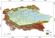
图1
研究区概况示意图"

表1
塔里木盆地农业光热资源开发潜力评价指标体系及数据来源"
| 准则层 | 指标层 | 指标定义 | 单位 | 数据来源 | 指标 |
|---|---|---|---|---|---|
| 光热资源禀赋 | 年日照时数 | 一年内日照时间的累计值 | h | 新疆第三次科学考察 | A1 |
| 年太阳辐射总量 | 一年内太阳辐射的累计值 | MJ·m-2 | A2 | ||
| ≥3 h有效日照天数 | 一年内日照时长≥3 h的天数 | d | A3 | ||
| ≥10 ℃活动积温 | 一年中日平均温稳定维持在≥10 ℃的日平均温度的总和 | ℃ | A4 | ||
| 年平均气温 | 全年各日平均气温的算术平均值 | ℃ | A5 | ||
| 年蒸发量 | 一年内区域表面的潜在(水面)蒸发量 | mm | A6 | ||
| 农业资源现状 | 水资源量 | 区域内地表和地下水资源总量 | 108 m3 | 新疆统计年鉴 | A7 |
| 农业水资源利用量 | 农业生产活动中利用的水资源量 | 108 m3 | A8 | ||
| 有效灌溉面积 | 能够得到有效灌溉的农田面积 | 103 hm2 | A9 | ||
| 农用地面积比重 | 区域内农用地占总面积的比重 | % | A10 | ||
| 农业基础设施投入 | 区域内农业基础设施的投入成本 | 104元 | A11 | ||
| 农业生态环境 | 土壤侵蚀模数 | 单位面积土地受到侵蚀的程度 | 遥感气候数据集 | A12 | |
| 人均GDP | 区域内人均生产总值 | 元 | 新疆统计年鉴 | A13 | |
| 农业总产值 | 区域内农业生产总值 | 104元 | A14 | ||
| 旱涝发生频率 | 区域内旱涝事件的发生比例 | % | A15/A16 | ||
| 退化耕地比重 | 耕地退化面积占耕地面积的比重 | % | A17 |
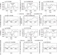
图2
1990—2020 年塔里木盆地农业光热资源年际变化趋势"

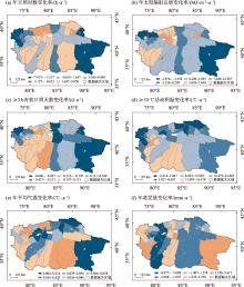
图3
塔里木盆地不同区县农业光热资源的年际变化倾向率"

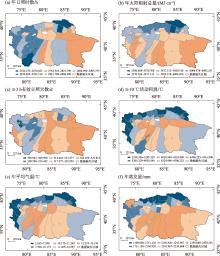
图4
塔里木盆地农业光热资源的空间分布"

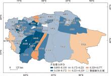
图5
塔里木盆地不同县区农业光热资源开发潜力的空间分布"

| [1] | Dhonde M, Sahu K, Murty V V S, et al. The application of solar-driven technologies for the sustainable development of agriculture farming: A comprehensive review[J]. Reviews in Environmental Science and Bio/Technology, 2022, 21(1): 1-29. |
| [2] | 周广学, 李普庆, 周晓东. 辽宁西部地区光热水资源变化对农业生产的影响[J]. 中国农业气象, 2011, 32(S1): 38-41. |
| [Zhou Guangxue, Li Puqing, Zhou Xiaodong. Impact of light, heat and water resources change in Western Liaoning Province on agricultural production[J]. Chinese Journal of Agrometeorology, 2011, 32(S1): 38-41. ] | |
| [3] | Hu Q, Pan F, Pan X, et al. Trends in agricultural heat and solar radiation resources in Northeast China: A multistage spatio-temporal analysis[J]. International Journal of Climatology, 2016, 36(6): 2461-2468. |
| [4] | Pascaris A S, Chelsea S, Laurie B, et al. Integrating solar energy with agriculture: Industry perspectives on the market, community, and socio-political dimensions of agrivoltaics[J]. Energy Research & amp: Social Science, 2021, 75: 102023. |
| [5] | Kumar C M S, Singh S, Kumar G M, et al. Solar energy: A promising renewable source for meeting energy demand in Indian agriculture applications[J]. Sustainable Energy Technologies and Assessments, 2023, 55: 102905. |
| [6] | 刘守仁. 关于西部大开发对新疆工作的要求[J]. 中国工程科学, 2000, 2(10): 59-62. |
| [Liu Shouren. Technology development of electric traction rail traffic[J]. Strategic Study of CAE, 2000, 2(10): 59-62. ] | |
| [7] | 陈文烈, 郑苗. 推进新时代西部大开发形成新格局——基于“以大开放促进大开发”的视角解读[J]. 开发研究, 2024, 5(1): 1-12. |
| [Chen Wenlie, Zheng Miao. Advancing the Great Western Development in the new era to form a new layout: An interpretation based on the perspective of “Promoting Great Development through Greater Opening-Up”[J]. Research on Development, 2024, 5(1): 1-12. ] | |
| [8] | 刘彬, 杨改河, 张丽萍. 南疆地区农业资源生产潜力分析与评价——以阿拉尔垦区为例[J]. 干旱区资源与环境, 2006, 20(3): 139-143. |
| [Liu Bin, Yang Gaihe, Zhang Liping. Analysis and evaluation on the production potential of agricultural resources in South Xinjiang area[J]. Journal of Arid Land Resources and Environment, 2006, 20(3): 139-143. ] | |
| [9] | 郭海英. 陇东黄土高原光、热、水对冬小麦产量的贡献及水资源开发利用研究[J]. 干旱区资源与环境, 2004, 18(6): 128-131. |
| [Guo Haiying. Contribute of sunlight temperature water to wheat output in winter and exploitation of water resource in Loess Plateau of Longdong[J]. Journal of Arid Land Resources and Environment, 2004, 18(6): 128-131. ] | |
| [10] | Zhang S, Chen Z, Cao C, et al. Photothermal-management agricultural films toward industrial planting: Opportunities and challenges[J]. Engineering, 2024, 35: 191-200. |
| [11] | 梁玉莲, 韩明臣, 白龙, 等. 中国近30年农业气候资源时空变化特征[J]. 干旱地区农业研究, 2015, 33(4): 259-267. |
| [Liang Yulian, Han Mingchen, Bai Long, et al. Spatial-temporal distribution and variation characteristics of the agricultural climate resources over recent 30 years in China[J]. Agricultural Research in the Arid Areas, 2015, 33(4): 259-267. ] | |
| [12] | 雷蕾, 李剑萍, 马力文, 等. 宁夏中宁县枸杞精细化气候区划[J]. 经济林研究, 2020, 38(3): 104-111. |
| [Lei Lei, Li Jianping, Ma Liwen, et al. A precise climate division of Lycium barbarum in Zhongning County, Ningxia[J]. Non-wood Forest Research, 2020, 38(3): 104-111. ] | |
| [13] | 李树岩, 方文松, 马志红. 河南省夏玉米生长季农业气候资源变化分析[J]. 河南农业科学, 2012, 41(7): 21-26. |
| [Li Shuyan, Fang Wensong, Ma Zhihong. Changes of agricultural climate resources in Henan Province during summer maize growing season[J]. Journal of Henan Agricultural Sciences, 2012, 41(7): 21-26. ] | |
| [14] | 杨鹏宇, 胡琦, 马雪晴, 等. 1961—2015年华北平原夏玉米生长季光热资源变化及其影响[J]. 中国农业气象, 2018, 39(7): 431-441. |
| [Yang Pengyu, Hu Qi, Ma Xueqing, et al. Spatiotemporal variation of heat and solar resources and its impact on summer maize in the North China Plain over the period 1961-2015[J]. Chinese Journal of Agrometeorology, 2018, 39(7): 431-441. ] | |
| [15] |
张玮, 严玲玲, 傅志强, 等. 播期对湖南省双季稻产量和光热资源利用效率的影响[J]. 中国农业科学, 2023, 56(1): 31-45.
doi: 10.3864/j.issn.0578-1752.2023.01.003 |
|
[Zhang Wei, Yan Lingling, Fu Zhiqiang, et al. Effects of sowing date on yield of double cropping rice and utilization efficiency of light and heat energy in Hunan Province[J]. Scientia Agricultura Sinica, 2023, 56(1): 31-45. ]
doi: 10.3864/j.issn.0578-1752.2023.01.003 |
|
| [16] | 米娜, 张富荣, 赵一俊, 等. 玉米间隔耕作秸秆条带还田增密集成技术光热资源利用效率评估[J]. 农业资源与环境学报, 2021, 38(3): 475-483. |
| [Mi Na, Zhang Furong, Zhao Yijun, et al. Evaluating the radiation and thermal use efficiency of the integrated technology of maize straw returning with alternate tillage and density increase[J]. Journal of Agricultural Resources and Environment, 2021, 38(3): 475-483. ] | |
| [17] | 姜丽娜, 李金娜, 齐红志, 等. 不同栽培模式冬小麦物质积累转运及光热资源利用研究[J]. 河南农业科学, 2018, 47(12): 14-19. |
| [Jiang Lina, Li Jinna, Qi Hongzhi, et al. Matter accumulation and transport of winter wheat and utilization of photothermal resources under different cultivation patterns[J]. Journal of Henan Agricultural Sciences, 2018, 47(12): 14-19. ] | |
| [18] | 叶彩华, 栾庆祖, 胡宝昆, 等. 北京农业气候资源变化特征及其对不同种植模式玉米各生育期的影响[J]. 自然资源学报, 2010, 25(8): 1350-1364. |
|
[Ye Caihua, Luan Qingzu, Hu Baokun, et al. Agricultural climate resources change characteristics of Beijing and related impacts on maize planted in different zones and different growth periods[J]. Journal of Natural Resources, 2010, 25(8): 1350-1364. ]
doi: 10.11849/zrzyxb.2010.08.012 |
|
| [19] |
蔡福, 张玉书, 陈鹏狮, 等. 近50年辽宁热量资源时空演变特征分析[J]. 自然资源学报, 2009, 24(9): 1635-1646.
doi: 10.11849/zrzyxb.2009.09.013 |
| [Cai Fu, Zhang Yushu, Chen Pengshi, et al. Spatio-temporal characteristics of Liaoning themal resources in recent 50 years[J]. Journal of Natural Resources, 2009, 24(9): 1635-1646. ] | |
| [20] | 李涛辉, 张文翔, 吕爱锋, 等. 云南省农业生长季热量资源的时空特征[J]. 山地学报, 2023, 41(3): 361-374. |
| [Li Taohui, Zhang Wenxiang, Lv Aifeng, et al. Temporal and spatial characteristics of heat resources in growing season in Yunnan Province, China[J]. Mountain Research, 2023, 41(3): 361-374. ] | |
| [21] | 刘晓迎, 陈罗成, 赵巧梅, 等. 豫北主要农作物光热资源利用效率研究[J]. 河南农业科学, 2012, 41(4): 29-33. |
| [Liu Xiaoying, Chen Luocheng, Zhao Qiaomei, et al. Light and heat utilization efficiency of winter wheat and summer maize in northern region of Henan Province[J]. Journal of Henan Agricultural Sciences, 2012, 41(4): 29-33. ] | |
| [22] | 张志高, 张秀丽, 贾梦薇, 等. 1960—2020年黄河流域农业热量资源时空演变特征[J]. 山西农业大学学报(自然科学版), 2024, 44(3): 119-130. |
| [Zhang Zhigao, Zhang Xiuli, Jia Mengwei, et al. Spatiotemporal evolution characteristics of agricultural thermal resources in the Yellow River Basin from 1960 to 2020[J]. Journal of Shanxi Agricultural University(Natural Science Edition), 2024, 44(3): 119-130. ] | |
| [23] |
刘淳, 任立清, 李学军, 等. 1990—2019年中国北方沙区太阳能资源评估[J]. 高原气象, 2021, 40(5): 1213-1223.
doi: 10.7522/j.issn.1000-0534.2021.00058 |
|
[Liu Chun, Ren Liqing, Li Xuejun, et al. Evaluation to the solar energy resources in the sandy regions of Northern China from 1990 to 2019[J]. Plateau Meteorology, 2021, 40(5): 1213-1223. ]
doi: 10.7522/j.issn.1000-0534.2021.00058 |
|
| [24] | 王畅, 赵海东, 冯乃杰, 等. 两个生态区大豆光热资源利用率和产量的差异及对化控剂的响应[J]. 应用生态学报, 2018, 29(11): 3615-3624. |
|
[Wang Chang, Zhao Haidong, Feng Naijie, et al. Differences in light and heat utilization efficiency and yield of soybean in two ecological zones and their response to chemical control regulators[J]. Chinese Journal of Applied Ecology, 2018, 29(11): 3615-3624. ]
doi: 10.13287/j.1001-9332.201811.021 |
|
| [25] | 岳伟, 陈金华, 阮新民, 等. 安徽省沿江地区双季稻光热资源利用效率变化特征及对气象产量的影响[J]. 中国生态农业学报(中英文), 2019, 27(6): 929-940. |
| [Yue Wei, Chen Jinhua, Ruan Xinmin, et al. Variation in characteristics of light and heat resource utilization efficiency of double-season rice and its impact on meteorological yield along the Yangtze River in Anhui Province[J]. Chinese Journal of Eco-Agriculture, 2019, 27(6): 929-940. ] | |
| [26] |
满苏尔·沙比提, 努尔卡木里·玉素甫. 塔里木河流域绿洲耕地变化及其河流水文效应[J]. 地理研究, 2010, 29(12): 2251-2260.
doi: 10.11821/yj2010120014 |
| [Mansur Shabiti, Nurkamuri Yusuf. Oasis land use change and its hydrological response to Tarim River Basin[J]. Geographical Research, 2010, 29(12): 2251-2260. ] | |
| [27] | He G, Kammen M D. Where, when and how much wind is available? A provincial-scale wind resource assessment for China[J]. Energy Policy, 2014, 7(4): 116-122. |
| [28] | 余国安, 李志威, 黄河清, 等. 人类活动影响下的干旱区河流地貌演变——以塔里木河为例[J]. 水科学进展, 2017, 28(2): 183-192. |
| [Yu Guo’an, Li Zhiwei, Huang Heqing, et al. Human impacts on fluvial processes in a very arid environment: Case of Tarim River in China[J]. Advances in Water Science, 2017, 28(2): 183-192. ] | |
| [29] | Li Z, Luo Z, Wang Y, et al. Suitability evaluation system for the shallow geothermal energy implementation in region by entropy weight method and TOPSIS method[J]. Renewable Energy, 2022, 18(4): 564-576. |
| [30] |
唐承财, 刘亚茹, 万紫微, 等. 传统村落文旅融合发展水平评价及影响路径[J]. 地理学报, 2023, 78(4): 980-996.
doi: 10.11821/dlxb202304013 |
|
[Tang Chengcai, Liu Yaru, Wan Ziwei, et al. Evaluation system and influencing paths of the integration of culture and tourism of traditional villages[J]. Acta Geographica Sinica, 2023, 78(4): 980-996. ]
doi: 10.11821/dlxb202304013 |
|
| [31] |
解智涵, 刘敏, 闫旭纲, 等. 黄河流域重要地质遗迹空间格局及地质旅游开发潜力评价[J]. 中国沙漠, 2024, 44(3): 128-139.
doi: 10.7522/j.issn.1000-694X.2024.00004 |
|
[Xie Zhihan, Liu Min, Yan Xugang, et al. Spatial pattern of important geological remains and evaluation of geotourism development potential in the Yellow River Basin[J]. Journal of Desert Research, 2024, 44(3): 128-139. ]
doi: 10.7522/j.issn.1000-694X.2024.00004 |
|
| [32] |
戴文渊, 玛久草, 陈亦晨, 等. 黄河流域甘肃段水生态安全驱动力分析及动态演变[J]. 干旱区研究, 2024, 41(10): 1662-1671.
doi: 10.13866/j.azr.2024.10.05 |
|
[Dai Wenyuan, Ma Jiucao, Chen Yichen, et al. Analysis of driving forces and dynamic evolution of water ecological security in the Gansu section of the Yellow River Basin[J]. Arid Zone Research, 2024, 41(10): 1662-1671. ]
doi: 10.13866/j.azr.2024.10.05 |
|
| [33] | 梁玉莲, 申彦波, 白龙, 等. 华南地区太阳能资源评估与开发潜力[J]. 应用气象学报, 2017, 28(4): 481-492. |
| [Liang Yulian, Shen Yanbo, Bai Long, et al. Assessment of solar energy resource and its exploitation potential in South China[J]. Journal of Applied Meteorological Science, 2017, 28(4): 481-492. ] | |
| [34] |
刘明, 吕爱锋, 武建军, 等. 干旱对农业生态系统影响研究进展[J]. 中国农学通报, 2014, 30(32): 165-171.
doi: 10.11924/j.issn.1000-6850.2014-0295 |
|
[Liu Ming, Lv Aifeng, Wu Jianjun, et al. A Review of impacts of drought on agro-ecosystem[J]. Chinese Agricultural Science Bulletin, 2014, 30(32): 165-171. ]
doi: 10.11924/j.issn.1000-6850.2014-0295 |
|
| [35] | Wang Y, Yang J, Chen Y, et al. Monitoring and predicting drought based on multiple indicators in an arid area, China[J]. Remote Sensing, 2020, 12(14): 2298. |
| [36] | 李涛辉, 尹鹏飞, 吕爱锋, 等. 中国东部季风区植被气候生产潜力的时空特征[J]. 东北林业大学学报, 2023, 51(10): 62-69, 91. |
| [Li Taohui, Yin Pengfei, Lv Aifeng, et al. Spatio-temporal characteristics of climate production potential of vegetation in Eastern Monsoon Region of China[J]. Journal of Northeast Forestry University, 2023, 51(10): 62-69, 91. ] | |
| [37] |
申彦波, 王传辉, 陈运. 中国东北三省地面太阳辐射变化及其对气温变化的影响[J]. 地理科学, 2023, 43(11): 2045-2052.
doi: 10.13249/j.cnki.sgs.2023.11.017 |
|
[Shen Yanbo, Wang Chuanhui, Chen Yun. Variation of surface solar radiation and its influence on temperature change in three provinces of Northeast China[J]. Scientia Geographica Sinica, 2023, 43(11): 2045-2052. ]
doi: 10.13249/j.cnki.sgs.2023.11.017 |
|
| [38] | 邓兴耀, 刘洋, 刘志辉, 等. 中国西北干旱区蒸散发时空动态特征[J]. 生态学报, 2017, 37(9): 2994-3008. |
| [Deng Xingyao, Liu Yang, Liu Zhihui, et al. Temporal-spatial dynamic change characteristics of evapotranspiration in arid region of Northwest China[J]. Acta Ecologica Sinica, 2017, 37(9): 2994-3008. ] | |
| [39] | Zheng Y, He J, Zhang W, et al. Assessing water security and coupling coordination in the Lancang-Mekong River Basin for sustainable development[J]. Sustainability, 2023, 15(24): 131-133. |
| [40] | Li T, Lv A, Zhang W, et al. Spatiotemporal characteristics of watershed warming and wetting: The response to atmospheric circulation in arid areas of Northwest China[J]. Atmosphere, 2023, 14(1): 151. |
| [41] | Williams K B, Martin M D. Dynamic use of agriculture incentives to promote conservation[J]. Journal of Environmental Management, 2024, 370(1): 25. |
| [42] |
张音, 孙从建, 刘庚, 等. 近20 a塔里木河流域山区NDSI对气候变化的响应[J]. 干旱区研究, 2024, 41(10): 1639-1648.
doi: 10.13866/j.azr.2024.10.03 |
|
[Zhang Yin, Sun Congjian, Liu Geng, et al. Response of NDSI in the Tarim River Basin mountainous areas to climate change over the past 20 years[J]. Arid Zone Research, 2024, 41(10): 1639-1648. ]
doi: 10.13866/j.azr.2024.10.03 |
|
| [43] |
许赟红, 刘琼, 陈勇航, 等. 新疆及周边中亚地区土地覆盖变化对地表反照率的影响[J]. 干旱区研究, 2024, 41(10): 1649-1661.
doi: 10.13866/j.azr.2024.10.04 |
|
[Xu Yunhong, Liu Qiong, Chen Yonghang, et al. Impact of land cover variations on surface albedo in Xinjiang and its surrounding Central Asian region[J]. Arid Zone Research, 2024, 41(10): 1649-1661. ]
doi: 10.13866/j.azr.2024.10.04 |
| [1] | 马超, 刘艳, 刘晶, 杨莲梅. 塔里木盆地夏季云水资源时空特征[J]. 干旱区研究, 2025, 42(2): 223-235. |
| [2] | 田文君, 薛一波, 张小啸, 雷加强, 李生宇, 范敬龙, 张恒. 2021年春季塔里木盆地典型沙尘天气过程气溶胶垂直分布及传输[J]. 干旱区研究, 2025, 42(1): 14-26. |
| [3] | 张莹, 赵媛媛, 刘如龙, 王岳, 丁国栋. 中国北方农牧交错带生境质量时空演变与情景模拟[J]. 干旱区研究, 2025, 42(1): 154-165. |
| [4] | 李宇航, 余文学, 杨永均, 朱燕峰, 马静, 陈浮. 近60 a天山北坡经济带天然径流量时空变化及归因识别[J]. 干旱区研究, 2024, 41(9): 1446-1455. |
| [5] | 山建安, 朱睿, 尹振良, 杨华庆, 张薇, 方春爽. 基于CMIP6模式的中国西北地区干旱时空变化[J]. 干旱区研究, 2024, 41(5): 717-729. |
| [6] | 朱从祯,赵天良,孟露,杨兴华,何清,买买提艾力·买买提依明. 塔里木盆地浮尘滞空天气客观分型[J]. 干旱区研究, 2023, 40(9): 1391-1403. |
| [7] | 孙贯芳, 高照良, 朱焱, 杨金忠, 屈忠义. 时空克里金评估河套灌区土壤盐分时空格局[J]. 干旱区研究, 2023, 40(2): 182-193. |
| [8] | 程红霞, 林粤江, 陈鹏, 梁凤超, 王勇. 塔里木盆地沙尘天气日数变化及影响因素[J]. 干旱区研究, 2023, 40(11): 1707-1717. |
| [9] | 裴宏泽, 赵亚超, 张廷龙. 2000—2020年黄土高原NEP时空格局与驱动力[J]. 干旱区研究, 2023, 40(11): 1833-1844. |
| [10] | 王娇娇, 尹小君, 刘陕南, 王帝盟. 基于深度学习的玛纳斯土地利用时空格局变化与预测[J]. 干旱区研究, 2023, 40(1): 69-77. |
| [11] | 龙志,孙颖琦,郎丽霞,陈兴鹏,张子龙,庞家幸. 黄土高原典型县域碳排放特征与时空格局——以庆城县为例[J]. 干旱区研究, 2022, 39(5): 1631-1641. |
| [12] | 李泽厚,李蕊希,张舒斌,王崇斌,郑明明,董叶卿,吴雪. 多枝柽柳叶片结构和化学性状对土壤水分变化的响应[J]. 干旱区研究, 2022, 39(5): 1486-1495. |
| [13] | 苏迎庆,张恩月,刘源,刘庚,林菲. 汾河流域土地利用变化及生态环境效应[J]. 干旱区研究, 2022, 39(3): 968-977. |
| [14] | 孙从建,陈伟,王诗语. 气候变化下的塔里木盆地西南部内陆河流域径流组分特征分析[J]. 干旱区研究, 2022, 39(1): 113-122. |
| [15] | 陈臻琦,张靖,张贻龙,刘睿. 基于VSD的近20 a来浑善达克沙地生态脆弱性变化研究[J]. 干旱区研究, 2021, 38(5): 1464-1473. |
|
||