干旱区研究 ›› 2024, Vol. 41 ›› Issue (7): 1120-1130.doi: 10.13866/j.azr.2024.07.04 cstr: 32277.14.AZR.20240704
龙威夷1,2,3( ), 施建飞1,2,3, 李双媛1,2,3, 孙金金1,2,3, 王玉刚1,2,3()
收稿日期:2024-03-12
修回日期:2024-04-05
出版日期:2024-07-15
发布日期:2024-08-01
通讯作者:
王玉刚. E-mail: wangyg@ms.xjb.ac.cn作者简介:龙威夷(1998-),男,硕士研究生,研究方向为土壤盐渍化过程模拟. E-mail: longweiyi21@mails.ucas.ac.cn
基金资助:
LONG Weiyi1,2,3(), SHI Jianfei1,2,3, LI Shuangyuan1,2,3, SUN Jinjin1,2,3, WANG Yugang1,2,3()
Received:2024-03-12
Revised:2024-04-05
Published:2024-07-15
Online:2024-08-01
摘要:
为更好地实现区域土壤盐分的监测和治理,促进绿洲可持续发展,本文基于气候、地形、植被等相关数据,结合三工河流域平原绿洲土壤表层盐分调查,对比评估不同模型(随机森林,支持向量机,决策树,普通克里金)土壤盐分反演效果。结果表明:绿洲土壤样本盐分含量为0.29~30.18 g·kg-1,平均值为4.06 g·kg-1,变异系数为149.73%,属于强变异;随机森林模型相较于其他模型具有更高的反演精度,决定系数、均方根误差和绝对平均误差分别为0.73、1.89 g·kg-1和1.49 g·kg-1;随机森林模型反演显示,高值区主要分布在西北部和中部区域,并且在9种环境协变量中,高程和地下水矿化度对土壤盐分反演精度影响较大。总的来说,以随机森林模型为手段的机器学习方法,不仅能够避免数据的平滑效应和图斑边界两侧的突变,还能有助于识别绿洲局部空间盐分状况,研究结果可为干旱区绿洲土壤盐渍化的长期监测提供技术和方法参考。
龙威夷, 施建飞, 李双媛, 孙金金, 王玉刚. 流域绿洲土壤盐分多模型反演效果评估[J]. 干旱区研究, 2024, 41(7): 1120-1130.
LONG Weiyi, SHI Jianfei, LI Shuangyuan, SUN Jinjin, WANG Yugang. Evaluation of multimodel inversion effects on soil salinity in oasis basin[J]. Arid Zone Research, 2024, 41(7): 1120-1130.
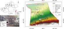
图1
研究区概况及采样点分布 注:底图采用自然资源部标准地图制作,审图号为GS(2019)3333号,对底图边界无修改。下同。"

表1
数据及来源"
| 数据名称 | 数据精度 | 数据格式 | 简介及来源 |
|---|---|---|---|
| 气象数据 | 1 km | TIFF | 气象数据包括气温和降水数据,采用的1901—2022年中国1 km逐月平均气温和降水量数据集,数据来源于国家科技基础条件平台—国家地球系统科学数据中心( |
| 高程数据 | 30 m | TIFF | 高程数据包括高程、坡向、坡度,数据来源于美国NASA和NGA的航天飞机雷达地形测绘项目(Shuttle Radar Topography Mission,SRTM)的成果产品,下载地址为 |
| 土壤湿度数据 | 1 km | TIFF | 土壤湿度数据采用2000—2020年中国1 km土壤湿度日尺度数据集,数据来源于“国家青藏高原科学数据中心”( |
| NDVI数据 | 30 m | TIFF | NDVI数据基于Google Earth Engine(GEE)平台,选择可用的Landsat 8数据的波段4(红光波段,R)和波段5(近红外波段,NIR)计算NDVI,其中NDVI=(NIR-R)/(NIR+R) |
| 矿化度数据 | 30 m | TIFF | 地下水矿化度数据采用研究区历史数据 |
| pH数据 | 30 m | TIFF | pH数据采用研究区实测数据 |
表2
三工河流域土壤含盐量描述性统计"
| 盐渍化等级 | 含盐量/(g·kg-1) | 数量占比/% | 均值/(g·kg-1) | 最小值/(g·kg-1) | 最大值/(g·kg-1) | 变异系数/% |
|---|---|---|---|---|---|---|
| 非盐渍化 | <3 | 68 | 1.02 | 0.29 | 2.86 | 66.81 |
| 轻度盐渍化 | 3~6 | 10 | 4.36 | 3.01 | 5.95 | 28.67 |
| 中度盐渍化 | 6~9 | 7 | 7.67 | 6.27 | 8.74 | 13.82 |
| 重度盐渍化 | 9~12 | 7 | 10.57 | 9.25 | 11.61 | 8.50 |
| 盐土化 | >12 | 8 | 20.79 | 13.40 | 30.18 | 27.86 |
| 总体样本 | 100 | 4.06 | 0.29 | 30.18 | 149.73 | |
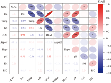
图2
土壤盐分与不同特征因子的相关性 注:*表示显著性检验P<0.05,**表示显著性检验P<0.01,***表示显著性检验P<0.001。NDVI、Pre、Temp、GS、DEM、Aspect、Slope、pH、SM、SSC分别表示归一化植被指数、降水、温度、地下水矿化度、高程、坡向、坡度、酸碱度、土壤湿度、土壤含盐量。下同。"
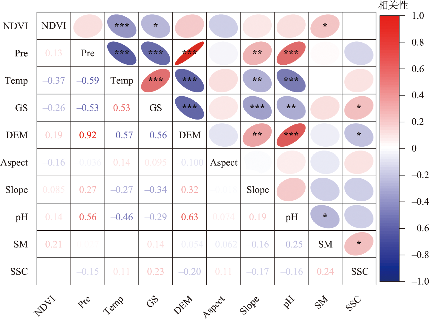
表3
不同模型土壤盐分反演精度统计"
| 模型 | 指标 | 最小值 /(g·kg-1) | 最大值 /(g·kg-1) | 均值 /(g·kg-1) | 标准差 /(g·kg-1) |
|---|---|---|---|---|---|
| RF | R2 | 0.66 | 0.87 | 0.73 | 0.05 |
| RMSE | 1.02 | 4.20 | 1.89 | 0.44 | |
| MAE | 0.86 | 3.11 | 1.49 | 0.33 | |
| SVM | R2 | 0.61 | 0.79 | 0.66 | 0.04 |
| RMSE | 1.35 | 1.92 | 1.73 | 0.15 | |
| MAE | 1.31 | 1.76 | 1.57 | 0.12 | |
| DT | R2 | 0.67 | 0.74 | 0.70 | 0.02 |
| RMSE | 0.56 | 2.33 | 1.66 | 0.42 | |
| MAE | 0.73 | 2.16 | 1.53 | 0.32 | |
| OK | R2 | 0.23 | 0.32 | 0.28 | 0.03 |
| RMSE | 3.74 | 5.23 | 4.46 | 0.41 | |
| MAE | 2.81 | 3.69 | 3.27 | 0.25 |
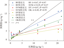
图3
不同模型预测值与实测值的相关性 注:k表示斜率,R2表示决定系数。"

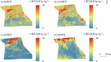
图4
不同模型预测的土壤盐分空间分布"

表4
不同模型对土壤盐分预测的统计"
| 模型 | 最小值 /(g·kg-1) | 均值 /(g·kg-1) | 最大值 /(g·kg-1) | 标准差 /(g·kg-1) |
|---|---|---|---|---|
| RF | 0.50 | 4.80 | 22.41 | 2.37 |
| SVM | 0.50 | 4.03 | 21.00 | 2.22 |
| DT | 0.29 | 3.91 | 30.18 | 5.26 |
| OK | 0.46 | 4.71 | 36.22 | 3.96 |
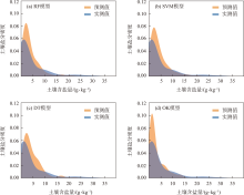
图5
不同模型预测值与实测值的土壤盐分密度"

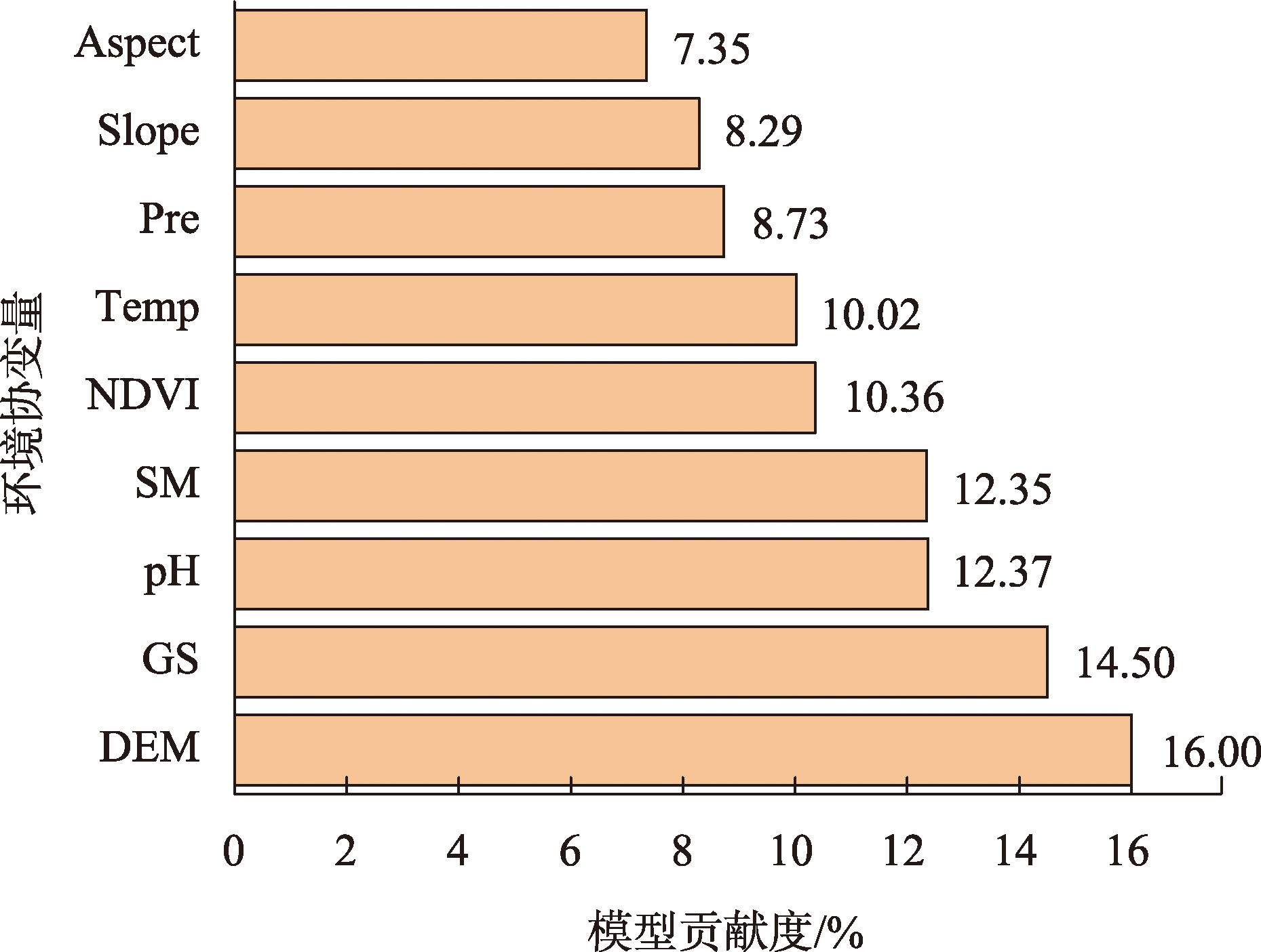
图6
不同环境协变量对RF模型的贡献度"
| [1] | Ivushkin K, Bartholomeus H, Bregt A K, et al. Global mapping of soil salinity change[J]. Remote Sensing of Environment, 2019, 231(51): 111260. |
| [2] | Zhang H R, Fu X, Zhang Y N, et al. Mapping multi-depth soil salinity using remote sensing-enabled machine learning in the yellow river delta, China[J]. Remote Sensing, 2023, 15(24): 5640. |
| [3] | 杨真, 王宝山. 中国盐渍土资源现状及改良利用对策[J]. 山东农业科学, 2015, 47(4): 125-130. |
| [Yang Zhen, Wang Baoshan. Present status of saline soil resources and countermeasures for improvement and utilization in China[J]. Shandong Agricultural Sciences, 2015, 47(4): 125-130.] | |
| [4] |
Hassani A, Azapagic A, Shokri N. Predicting long-term dynamics of soil salinity and sodicity on a global scale[J]. Proceedings of the National Academy of Sciences of the United States of America, 2020, 117(52): 33017-33027.
doi: 10.1073/pnas.2013771117 pmid: 33318212 |
| [5] | Li J, Zhang T T, Shao Y, et al. Comparing machine learning algorithms for soil salinity mapping using topographic factors and Sentinel-1/2 data: A case study in the yellow river delta of China[J]. Remote Sensing, 2023, 15(9): 2332. |
| [6] | Wang Y G, Li Y. Land exploitation resulting in soil salinization in a desert-oasis ecotone[J]. Catena, 2013, 100: 50-56. |
| [7] | Wang J Z, Ding J L, Yu D L, et al. Capability of Sentinel-2 MSI data for monitoring and mapping of soil salinity in dry and wet seasons in the Ebinur Lake Region, Xinjiang, China[J]. Geoderma, 2019, 353(53): 172-187. |
| [8] | 彭杰, 王家强, 向红英, 等. 土壤含盐量与电导率的高光谱反演精度对比研究[J]. 光谱学与光谱分析, 2014, 34(2): 510-514. |
|
[Peng Jie, Wang Jiaqiang, Xiang Hongying, et al. Comparative study on hyperspectral inversion accuracy of soil salt content and electrical conductivity[J]. Spectroscopy and Spectral Analysis, 2014, 34(2): 510-514.]
pmid: 24822430 |
|
| [9] | Harti A E, Lhissou R, Chokmani K, et al. Spatiotemporal monitoring of soil salinization in irrigated Tadla Plain (Morocco) using satellite spectral indices[J]. International Journal of Applied Earth Observation and Geoinformation, 2016, 50(18): 64-73. |
| [10] | 李建国, 濮励杰, 朱明, 等. 土壤盐渍化研究现状及未来研究热点[J]. 地理学报, 2012, 67(9): 1233-1245. |
|
[Li Jianguo, Pu Lijie, Zhu Ming, et al. The present situation and hot issues in the salt-affected soil research[J]. Acta Geographica Sinica, 2012, 67(9): 1233-1245.
doi: 10.11821/xb201209008 |
|
| [11] | Wang Y G, Deng C Y, Liu Y, et al. Identifying change in spatial accumulation of soil salinity in an inland river watershed, China[J]. Science of The Total Environment, 2018, 621(47): 177-185. |
| [12] | Li H Y, Shi Z, Webster R, et al. Mapping the three-dimensional variation of soil salinity in a rice-paddy soil[J]. Geoderma, 2013, 195(47): 31-41. |
| [13] | Wang J Q, Peng J, Li H Y, et al. Soil salinity mapping using machine learning algorithms with the Sentinel-2 MSI in arid areas, China[J]. Remote Sensing, 2021, 13(2): 305. |
| [14] | Vermeulen D, Niekerk A V. Machine learning performance for predicting soil salinity using different combinations of geomorphometric covariates[J]. Geoderma, 2017, 299(51): 1-12. |
| [15] | Mohamed S A, Metwaly M M, Metwalli M R, et al. Integrating active and passive remote sensing data for mapping soil salinity using machine learning and feature selection approaches in arid regions[J]. Remote Sensing, 2023, 15(7): 1751. |
| [16] | Farifteh J, Meer F V D, Atzberger C, et al. Quantitative analysis of salt-affected soil reflectance spectra: A comparison of two adaptive methods (PLSR and ANN)[J]. Remote Sensing of Environment, 2007, 110(1): 59-78. |
| [17] | Golestani M, Ghahfarokhi Z M, Esfandiarpour-Boroujeni I, et al. Evaluating the spatiotemporal variations of soil salinity in Sirjan Playa, Iran using Sentinel-2A and Landsat-8 OLI imagery[J]. Catena, 2023, 231(51): 107375. |
| [18] | 李小雨, 贾科利, 魏慧敏, 等. 基于随机森林算法的土壤含盐量预测[J]. 干旱区研究, 2023, 40(8): 1258-1267. |
| [Li Xiaoyu, Jia Keli, Wei Huimin, et al. Prediction of soil salt content based on the random forest algorithm[J]. Arid Zone Research, 2023, 40(8): 1258-1267.] | |
| [19] | 蒙莉娜, 丁建丽, 王敬哲, 等. 基于环境变量的渭干河-库车河绿洲土壤盐分空间分布[J]. 农业工程学报, 2020, 36(1): 175-181. |
| [Meng Lina, Ding Jianli, Wang Jingzhe, et al. Spatial distribution of soil salinity in Ugan-Kuqa River delta oasis based on environmental variables[J]. Transactions of the Chinese Society of Agricultural Engineering, 2020, 36(1): 175-181.] | |
| [20] | 杨清, 范晓梅, 王林林, 等. 基于贝叶斯最大熵的黄河三角洲土壤含盐量空间分布预测[J]. 土壤, 2024, 56(2): 406-414. |
| [Yang Qing, Fan Xiaomei, Wang Linlin, et al. Prediction of spatial distribution of soil salinity content in Yellow River Delta based on Bayesian Maximum Entropy Model[J]. Soils, 2024, 56(2): 406-414.] | |
| [21] | 鲁如坤. 土壤农业化学分析方法[M]. 北京: 中国农业科技出版社, 2000. |
| [Lu Rukun, The Analysis Method of Soil Agricultural Chemistry[M]. Beijing: China Agricultural Science and Technology Press, 2000.] | |
| [22] | 陈炳铭, 冯文婷, 王玉刚, 等. 脱硫石膏在碱土改良中的无机固碳作用[J]. 土壤学报, 2024, 61(1): 247-257. |
| [Chen Bingming, Feng Wenting, Wang Yugang, et al. Inorganic carbon sequestration effect of desulfurized gypsum in alkaline soil improvement[J]. Acta Pedologica Sinica, 2024, 61(1): 247-257.] | |
| [23] | Sarkar S K, Rudra R R, Sohan A R, et al. Coupling of machine learning and remote sensing for soil salinity mapping in coastal area of Bangladesh[J]. Scientific Reports, 2023, 13(1): 17056. |
| [24] | 朱婉怡, 张振克, 郭新亚, 等. 马拉河流域植被生态需水特征及估算[J]. 生态学报, 2023, 43(18): 7523-7535. |
| [Zhu Wanyi, Zhang Zhenke, Guo Xinya, et al. Characteristics and estimation of vegetation ecological water demand in the Mara River Basin[J]. Acta Ecologica Sinica, 2023, 43(18): 7523-7535.] | |
| [25] | 马国林, 丁建丽, 韩礼敬, 等. 基于变量优选与机器学习的干旱区湿地土壤盐渍化数字制图[J]. 农业工程学报, 2020, 36(19): 124-131. |
| [Ma Guolin, Ding Jianli, Han Lijing, et al. Digital mapping of soil salinization in arid area wetland based on variable optimized selection and machine learning[J]. Transactions of the Chinese Society of Agricultural Engineering, 2020, 36(19): 124-131.] | |
| [26] | Huang Y, Zhao L. Review on landslide susceptibility mapping using support vector machines[J]. Catena, 2018, 165(46): 520-529. |
| [27] | 王海江, 蒋天池, Yunger J A, 等. 基于支持向量机的土壤主要盐分离子高光谱反演模型[J]. 农业机械学报, 2018, 49(5): 263-270. |
| [Wang Haijiang, Jiang Tianchi, Yonger J A, et al. Hyperspectral inverse model for soil salt ions based on support vector machine[J]. Transactions of the Chinese Society for Agricultural Machinery, 2018, 49(5): 263-270.] | |
| [28] | Haq Y U, Shahbaz M, Asif H M S, et al. Spatial mapping of soil salinity Using Machine Learning and Remote Sensing in Kot Addu, Pakistan[J]. Sustainability, 2023, 15(17): 12943. |
| [29] | Bouquet A, Laabir M, Rolland J l, et al. Prediction of Alexandrium and Dinophysis algal blooms and shellfish contamination in French Mediterranean Lagoons using decision trees and linear regression: A result of 10 years of sanitary monitoring[J]. Harmful Algae, 2022, 115(21): 102234. |
| [30] | 韩文霆, 崔家伟, 崔欣, 等. 基于特征优选与机器学习的农田土壤含盐量估算研究[J]. 农业机械学报, 2023, 54(3): 328-337. |
| [Han Wenting, Cui Jiawei, Cui Xin, et al. Estimation of farmland soil salinity content based on feature optimization and machine learning algorithms[J]. Transactions of the Chinese Society for Agricultural Machinery, 2023, 54(3): 328-337.] | |
| [31] | 陈琳, 任春颖, 王宗明, 等. 基于克里金插值的耕地表层土壤有机质空间预测[J]. 干旱区研究, 2017, 34(4): 798-805. |
| [Chen Lin, Ren Chunying, Wang Zongming, et al. Prediction of spatial distribution of topsoil organic matter content in cultivated land using Kriging methods[J]. Arid Zone Research, 2017, 34(4): 798-805.] | |
| [32] | 刘新, 郝媛媛, 花立民. 石羊河下游民勤盆地土壤盐分空间分异特征[J]. 干旱区研究, 2023, 40(10): 1615-1624. |
| [Liu Xin, Hao Yuanyuan, Hua Limin. Spatial differentiation characteristics of soil salinity in Minqin Basin, downstream of Shiyang River, China[J]. Arid Zone Research, 2023, 40(10): 1615-1624.] | |
| [33] | 王瑾杰, 丁建丽, 张子鹏, 等. 基于多模型对比的土壤盐分制图及不确定性研究[J]. 新疆大学学报(自然科学版), 2022, 39(5): 513-521, 529. |
| [Wang Jinjie, Ding Jianli, Zhang Zipeng, et al. Study on soil salinity mapping and uncertainty based on multi model comparison[J]. Journal of Xinjiang University (Natural Science Edition in Chinese and English), 2022, 39(5): 513-521, 529.] | |
| [34] | 王飞, 杨胜天, 丁建丽, 等. 环境敏感变量优选及机器学习算法预测绿洲土壤盐分[J]. 农业工程学报, 2018, 34(22): 102-110. |
| [Wang Fei, Yang Shengtian, Ding Jianli, et al. Environmental sensitive variable optimization and machine learning algorithm using in soil salt prediction at oasis[J]. Transactions of the Chinese Society of Agricultural Engineering, 2018, 34(22): 102-110.] | |
| [35] | 段梦琦, 张晓光, 王豹. 黄河三角洲典型区土壤盐分空间分布预测方法研究[J]. 中国农业资源与区划, 2021, 42(8): 243-250. |
| [Duan Mengqi, Zhang Xiaoguang, Wang Bao. Prediction method of spatial distribution for soil salinity in typical areas of the yellow river delta[J]. Chinese Journal of Agricultural Resources and Regional Planning, 2021, 42(8): 243-250.] | |
| [36] | 颜安, 蒋平安, 盛建东, 等. 玛纳斯河流域表层土壤盐分空间变异特征研究[J]. 土壤学报, 2014, 51(2): 410-414. |
| [Yan An, Jiang Ping’an, Sheng Jiandong, et al. Spatial variability of surface soil salinity in Manas River Basin[J]. Acta Pedologica Sinica, 2014, 51(2): 410-414.] | |
| [37] | Ge X Y, Ding J L, Teng D X, et al. Updated soil salinity with fine spatial resolution and high accuracy: The synergy of Sentinel-2 MSI, environmental covariates and hybrid machine learning approaches[J]. Catena, 2022, 212(50): 106054. |
| [38] |
卫雨西, 陈丽娟, 席海洋, 等. 石羊河流域土壤水分和电导率的空间分布特征[J]. 中国沙漠, 2023, 43(3): 264-273.
doi: 10.7522/j.issn.1000-694X.2023.00038 |
|
[Wei Yuxi, Chen Lijuan, Xi Haiyang, et al. Spatial differentiation of soil moisture and conductivity in Shiyang River Basin[J]. Journal of Desert Research, 2023, 43(3): 264-273.]
doi: 10.7522/j.issn.1000-694X.2023.00038 |
|
| [39] | 徐英, 葛洲, 王娟, 等. 基于指示Kriging法的土壤盐渍化与地下水埋深关系研究[J]. 农业工程学报, 2019, 35(1): 123-130. |
| [Xu Ying, Ge Zhou, Wang Juan, et al. Study on relationship between soil salinization and groundwater table depth based on indicator Kriging[J]. Transactions of the Chinese Society of Agricultural Engineering, 2019, 35(1): 123-130.] | |
| [40] | 陈永宝, 胡顺军, 罗毅, 等. 新疆喀什地下水浅埋区弃荒地表层土壤积盐与地下水的关系[J]. 土壤学报, 2014, 51(1): 75-81. |
| [Chen Yongbao, Hu Shunjun, Luo Yi, et al. Relationship between salt accumulation in topsoil of deserted land and groundwater in areas with shallow groundwater table in Kashi, Xinjiang[J]. Acta Pedologica Sinica, 2014, 51(1): 75-81.] | |
| [41] | 麦麦提吐尔逊·艾则孜, 米热古力·艾尼瓦尔, 古丽孜巴·艾尼瓦尔, 等. 伊犁绿洲土壤盐渍化与浅层地下水水化学特征分析[J]. 干旱地区农业研究, 2015, 33(5): 193-200, 257. |
| [Mamattursun Eziz, Mihrigul Anwar, Gulziba Anwar, et al. Analysis on soil salinization and hydrochemical characteristics of shallow ground water in Ili Oasis[J]. Agricultural Research in the Arid Areas, 2015, 33(5): 193-200, 257.] | |
| [42] | 高婷婷, 丁建丽, 哈学萍, 等. 基于流域尺度的土壤盐分空间变异特征——以渭干河-库车河流域三角洲绿洲为例[J]. 生态学报, 2010, 30(10): 2695-2705. |
| [Gao Tingting, Ding Jianli, Ha Xueping, et al. The spatial variability of salt content based on river basin scale: A case study of the delta oasis in Weigan-Kuqa Watershed[J]. Acta Ecologica Sinica, 2010, 30(10): 2695-2705.] |
| [1] | 王婷, 沈赣华, 刘兵, 孙莹琳, 汪再光. 天山北坡经济带水库群时空变化特征及驱动机制[J]. 干旱区研究, 2024, 41(9): 1456-1467. |
| [2] | 吕壮壮, 乔庆庆, 董孙艺, 汪冬. 中中新世气候适宜期全球变暖背景下亚洲内陆干旱区古气候演化特征及驱动机制[J]. 干旱区研究, 2024, 41(8): 1309-1322. |
| [3] | 王怡雯, 马瑶瑶, 史培军, 张钢锋. 干旱区光伏电站运营对局地生态环境的影响[J]. 干旱区研究, 2024, 41(8): 1423-1433. |
| [4] | 叶虎, 裴浩, 姜艳丰, 那庆, 张立伟. 内蒙古半干旱区气溶胶散射特性及影响因素[J]. 干旱区研究, 2024, 41(5): 730-741. |
| [5] | 雷菲亚, 李小双, 陶冶, 尹本丰, 荣晓莹, 张静, 陆永兴, 郭星, 周晓兵, 张元明. 西北干旱区藓类结皮覆盖下土壤多功能性特征及影响因子[J]. 干旱区研究, 2024, 41(5): 812-820. |
| [6] | 洪国军, 谢俊博, 张灵, 范振岐, 喻彩丽, 付仙兵, 李旭. 基于多光谱影像的阿拉尔垦区棉田土壤盐分反演[J]. 干旱区研究, 2024, 41(5): 894-904. |
| [7] | 程秋连, 刘杰, 杨治纬, 张天意, 王斌. 独库高速阿尔先沟段雪崩空间分布及因子探测[J]. 干旱区研究, 2024, 41(2): 220-229. |
| [8] | 袁萍, 韩欢, 赵红梅, 李从娟. 裸露与沙埋对极端干旱区凋落物分解和养分释放的影响[J]. 干旱区研究, 2024, 41(2): 293-300. |
| [9] | 张寿川, 赵春涛, 安亚涛, 刘凯, 余冬梅, 陈亮, 李庆宽, 王建萍. 那棱格勒河流域氢氧同位素特征及其指示意义[J]. 干旱区研究, 2024, 41(11): 1853-1863. |
| [10] | 侯聪, 史海滨, 苗庆丰, 胡智远, 赵毅, 于翠翠, 闫妍, 范理权, 张涛. 河套灌区农田地下水化学特征与不同地类水盐迁移[J]. 干旱区研究, 2024, 41(11): 1956-1968. |
| [11] | 汪翔, 吕海深, 朱永华, 郭晨煜. 两种河道洪水演进方法在新疆山区的应用比较[J]. 干旱区研究, 2023, 40(8): 1240-1247. |
| [12] | 赵卓怡, 郝兴明. 基于Priestley-Taylor方法的中亚干旱区实际蒸散特征及归因[J]. 干旱区研究, 2023, 40(7): 1085-1093. |
| [13] | 石建周, 刘贤德, 田青, 于澎涛, 王彦辉. 六盘山半干旱区华北落叶松林坡面土壤含水量的降雨响应[J]. 干旱区研究, 2023, 40(4): 594-604. |
| [14] | 赵美亮, 曹广超, 赵青林, 曹生奎. 气候及土地利用变化对大通河源区水文要素空间分布的影响[J]. 干旱区研究, 2023, 40(3): 381-391. |
| [15] | 孙贯芳, 高照良, 朱焱, 杨金忠, 屈忠义. 时空克里金评估河套灌区土壤盐分时空格局[J]. 干旱区研究, 2023, 40(2): 182-193. |
|
||