干旱区研究 ›› 2023, Vol. 40 ›› Issue (10): 1615-1624.doi: 10.13866/j.azr.2023.10.08 cstr: 32277.14.AZR.20231008
刘新( ),郝媛媛(),花立民
收稿日期:2023-03-08
修回日期:2023-06-27
出版日期:2023-10-15
发布日期:2023-11-01
作者简介:刘新(1997-),男,硕士研究生,主要从事土壤恢复生态遥感工作. E-mail: 基金资助:
LIU Xin(),HAO Yuanyuan(),HUA Limin
Received:2023-03-08
Revised:2023-06-27
Published:2023-10-15
Online:2023-11-01
摘要:
明晰土壤盐分空间变异性是土壤盐渍化程度研究和盐碱地改良的前提。本研究选取干旱内陆河流域石羊河下游民勤盆地为研究区,通过对0~30 cm土层土壤盐分原位数据统计学特征、空间自相关性、变异性和分布格局的分析,探讨民勤盆地土壤盐分空间异质性变化规律,以期为研究区土壤盐渍化治理提供理论依据。结果显示:(1)实测土壤盐分含量和变化范围均随土层加深而变小,且均呈偏正态分布。(2)Moran’s I 指数均呈“∽”型波动趋势且值域范围随土层加深而变大,正(负)空间自相关性均随距离的增大而减小(0~10 cm负的空间自相关性相反)。(3)变异函数均以指数模型为最好,R2随土层加深而变大(0.62→0.69→0.81),RSS均是0.0002,C0/(C0+C)和A0变化规律一致,随着土层加深空间异质性由弱到强烈再到中等。(4)插值精度10~20 cm > 20~30 cm > 0~10 cm。3个土层土壤盐分均存在空间分异特性,水平方向(同一土层)上,盐渍化程度均自西南向东北逐渐增加;垂直方向(不同土层)上,分布规律由简单到复杂,从聚集状态(0~10 cm)逐渐趋于斑块化(10~20 cm)和斑点化(20~30 cm)。非盐化土(<1.50%)和4种不同程度盐渍土在3个土层中均有分布,盐渍土面积中度(>70.00%)>强度(约20.00%)>轻度(约9.00%)>盐土(<0.50%)。
刘新, 郝媛媛, 花立民. 石羊河下游民勤盆地土壤盐分空间分异特征[J]. 干旱区研究, 2023, 40(10): 1615-1624.
LIU Xin, HAO Yuanyuan, HUA Limin. Spatial differentiation characteristics of soil salinity in Minqin Basin, downstream of Shiyang River, China[J]. Arid Zone Research, 2023, 40(10): 1615-1624.
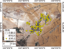
图1
研究区地理位置及采样点分布"

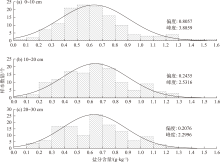
图2
样点盐分含量正态分布"

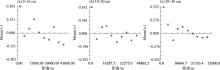
图3
土壤各层盐分Moran’s I指数"

表1
土壤各层盐分的变异函数理论模型及相关参数"
| 土层/cm | 变异模型 | 块金值 C0 | 基台值 C0+C | 基底效应 C0/(C0+C) | 变程 A0/km | 决定系数 R2 | 残差 RSS |
|---|---|---|---|---|---|---|---|
| 0~10 | 指数模型 | 0.060 | 0.076 | 0.79 | 44.64 | 0.62 | 0.0002 |
| 10~20 | 指数模型 | 0.008 | 0.066 | 0.13 | 8.79 | 0.69 | 0.0002 |
| 20~30 | 指数模型 | 0.026 | 0.065 | 0.40 | 18.09 | 0.81 | 0.0002 |

图4
不同土层的土壤盐分空间分布"
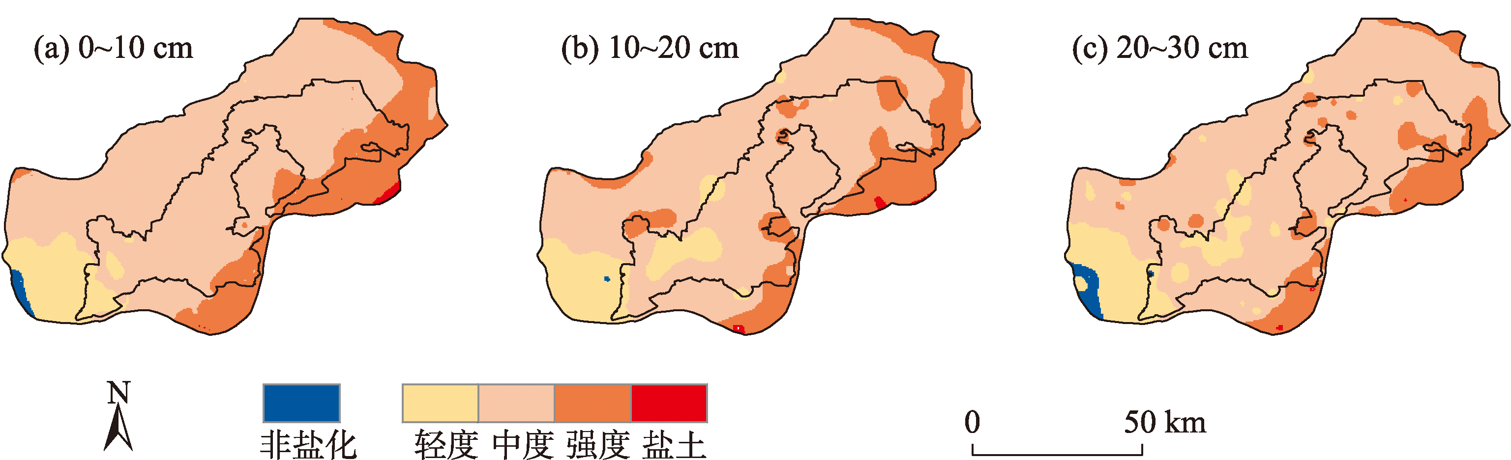
表2
不同土层土壤盐分插值模型验证结果"
| 土层/cm | 平均误差 ME | 均方根误差 RMSE | 标准均值误差 MSE | 标准均方根误差 RMSSE | 平均标准误差 ASE |
|---|---|---|---|---|---|
| 0~10 | -0.004 | 0.25 | -0.018 | 1.13 | 0.22 |
| 10~20 | 0.001 | 0.22 | 0.002 | 0.98 | 0.23 |
| 20~30 | 0.006 | 0.21 | 0.017 | 1.03 | 0.21 |
表3
不同土层的土壤盐分面积占比"
| 土层/cm | 非盐土/% | 轻度盐渍土/% | 中度盐渍土/% | 强度盐渍土/% | 盐渍土/% |
|---|---|---|---|---|---|
| 0~10 | 0.63 | 3.12 | 72.44 | 23.43 | 0.37 |
| 10~20 | 0.03 | 12.20 | 71.59 | 22.59 | 0.38 |
| 20~30 | 1.27 | 14.15 | 75.80 | 15.49 | 0.09 |
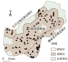
图5
沙漠边缘采样区域的对比"

表4
沙漠边缘区域统计信息对比"
| 区域 | 采样点数 | 范围/(g·kg-1) | 平均值/(g·kg-1) | 标准差/(g·kg-1) | 标准误差/(g·kg-1) | 中位数/(g·kg-1) |
|---|---|---|---|---|---|---|
| 巴丹吉林沙漠边缘区 | 22个 | 1.31~32.08 | 3.96 | 2.05 | 0.44 | 3.33 |
| 民勤盆地腹地 | 70个 | 1.29~23.18 | 4.86 | 3.77 | 0.49 | 3.82 |
| 腾格里沙漠边缘区 | 38个 | 1.18~8.89 | 7.76 | 6.85 | 1.11 | 5.70 |
| [1] | 边慧芹, 王雪梅. 基于多光谱影像的干旱区绿洲耕层土壤盐分估算[J]. 干旱区资源与环境, 2022, 36(5): 110-118. |
| [Bian Huiqin, Wang Xuemei. Estimation of soil salinity in cultivated layers of oasis in arid areas based on multispectral images[J]. Journal of Arid Land Resources and Environment, 2022, 36(5): 110-118.] | |
| [2] |
赵玉, 冯起, 李会亚. 黑河下游土壤盐分分布特征[J]. 中国沙漠, 2017, 37(6): 1196-1203.
doi: 10.7522/j.issn.1000-694X.2016.00127 |
|
[Zhao Yu, Feng Qi, Li Huiya. Distribution characteristics of soil salts in the lower reaches of Heihe River, Northwest China[J]. Journal of Desert Research, 2017, 37(6): 1196-1203.]
doi: 10.7522/j.issn.1000-694X.2016.00127 |
|
| [3] | 孙晓庆, 卞建民, 赵玉红, 等. 盐渍土水分下渗能力及水盐动态运移试验[J]. 实验室研究与探索, 2021, 40(2): 12-17. |
| [Sun Xiaoqing, Bian Jianmin, Zhao Yuhong, et al. An experimental study on water infiltration capacity and water-salt dynamic transport of saline soil[J]. Research and Exploration in Laboratory, 2021, 40(2): 12-17.] | |
| [4] | 杨广, 李万精, 任富天, 等. 不同矿化度咸水膜下滴灌棉花土壤盐分累积规律及其数值模拟[J]. 农业工程学报, 2021, 37(19): 73-83. |
| [Yang Guang, Li Wanjing, Ren Futian, et al. Soil salinity accumulation and model simulation of cotton under mulch drip irrigation with different salinity level water[J]. Transactions of the Chinese Society of Agricultural Engineering, 2021, 37(19): 73-83.] | |
| [5] | 聂春. 内蒙古典型草地坡面土壤理化性质空间异质性研究[D]. 呼和浩特: 内蒙古农业大学, 2012. |
| [Nie Chun. Spatial Heterogeneity of Soil Physical-Chemical Properties in Typical Crass Slope of Inner Mongolia[D]. Hohhot: Inner Mongolia Agricultural University, 2012.] | |
| [6] | 时雷雷. 海南尖峰岭热带山地雨林原始林土壤理化性质空间异质性研究[D]. 北京: 中国林业科学研究院, 2012. |
| [Shi Leilei. Study on the Spatial Heterogeneity of Soil Physical and Chemical Properties of Primary Tropical Montane Rainforest in Jianfengling, Hainan Island[D]. Beijing: Chinese Academy of Forestry, 2012.] | |
| [7] | 杜萍, 徐晓群, 刘晶晶, 等. 象山港春、夏季大中型浮游动物空间异质性[J]. 生态学报, 2015, 35(7): 2308-2321. |
| [Du Ping, Xu Xiaoqun, Liu Jinijn, et al. Spatial heterogeneity of macro-and meso-zooplankton in Xiangshan Bay in spring and summer[J]. Acta Ecologica Sinica, 2015, 35(7): 2308-2321.] | |
| [8] | 严冬春, 文安邦, 鲍玉海, 等. 岩溶坡地土壤空间异质性的表述与调查方法——以贵州清镇市王家寨坡地为例[J]. 地球与环境, 2008, 36(2): 130-135. |
| [Yan Dongcun, Wen Anbang, Bao Yuhai, et al. Expression and investigation methods of soil spatial heterogeneity in karst slope-as exemplified by Wangjiazhai slope in Qingzhen City, Guizhou Province[J]. Earth and Environment, 2008, 36(2): 130-135.] | |
| [9] | 郝媛媛. 基于GIS/RS的西北内陆河流域生态恢复效果评价研究[D]. 兰州: 兰州大学, 2017. |
| [Hao Yuanyuan. Evaluation of Ecological Restoration Effects Based on GIS/RS for Northwest Inland River Basin, China-A Case Study of Minqin Basin in the Downstream of Shiyang River[D]. Lanzhou: Lanzhou University, 2017.] | |
| [10] |
李军豪, 陈勇, 杨国靖, 等. 1975—2018年民勤绿洲沙漠化过程及其驱动机制[J]. 中国沙漠, 2021, 41(3): 44-55.
doi: 10.7522/j.issn.1000-694X.2021.00014 |
|
[Li Junhao, Chen Yong, Yang Guojing, et al. The aeolian desertification process and driving mechanism of Minqin Oasis from 1975 to 2018[J]. Journal of Desert Research, 2021, 41(3): 44-55.]
doi: 10.7522/j.issn.1000-694X.2021.00014 |
|
| [11] | 王新源, 陈翔舜, 丁乾平, 等. 不同荒漠化阶段植被生态特征对土壤环境因子的响应——以民勤荒漠绿洲过渡带为例[J]. 生态学报, 2018, 38(5): 1569-1580. |
| [Wang Xinyuan, Chen Xiangshun, Ding Qianping, et al. Vegetation and soil environmental factor characteristics, and their relationship at different desertification stages: A case study in the Minqin desert-oasis ecotone[J]. Acta Ecologica Sinica, 2018, 38(5): 1569-1580.] | |
| [12] | 王蕊. 甘肃民勤连古城国家级自然保护区荒漠植被群落及土壤特征初步分析[D]. 兰州: 兰州交通大学, 2021. |
| [Wang Rui. Preliminary Analysis of Desert Vegetation Community and Soil Properties in Liangucheng National Reserve in Minqin County, Gansu Province[D]. Lanzhou: Lanzhou Jiaotong University, 2021.] | |
| [13] | 滑永春, 李增元, 高志海. 2001年以来甘肃民勤植被覆盖变化分析[J]. 干旱区研究, 2017, 34(2): 337-343. |
| [Hua Yongcun, Li Zengyuan, Gao Zhihai. Variation of vegetation coverage in Minqin County since 2001[J]. Arid Zone Research, 2017, 34(2): 337-343.] | |
| [14] | 鲍士旦. 土壤农化分析[M]. 北京: 中国农业出版社, 2000: 183-199. |
| [Bao Shidan. Soil Agrochemical Analysis[M]. Beijing: China Agricultural Press, 2000: 183-199.] | |
| [15] | 卢磊, 乔木, 周生斌, 等. 新疆渭干河流域土壤盐渍化及其驱动力分析[J]. 农业现代化研究, 2011, 32(3): 357-361. |
| [Lu Lei. Qiao Mu, Zhou Shengbin, et al. Analysis on characteristics and driver forces of soil salinization in Weigan River Basin, Xinjiang[J]. Research of Agricultural Modernization, 2011, 32(3): 357-361.] | |
| [16] | 乔木, 田长彦, 王新平, 等. 新疆灌区土壤盐渍化及改良治理模式[M]. 乌鲁木齐: 新疆科学技术出版社, 2008. |
| [Qiao Mu, Tian Changyan, Wang Xinping, et al. Soil Aalinization and Improvement Model in Xinjiang Irrigation District[M]. Urumqi: Xinjiang Science and Technology Press, 2008.] | |
| [17] | 王遵亲, 祝寿泉, 俞仁培, 等. 中国盐渍土[M]. 北京: 科学出版社, 1993: 131-133. |
| [Wang Zunqin, Zhu Shouquan, Yu Renpei, et al. Saline Soil in China[M]. Beijing: Science Press, 1993: 131-133.] | |
| [18] | 陶金卫. 文山州年降水量统计特性分析[C]// 云南省科学技术协会, 云南省水利学会2015年度学术年会. 北京: 中国会议, 2015: 693-697. |
| [Tao Jinwei. Monte-carlo method and K-S test for reliability analysis of accumulation slopes’ stability[C]// Yunnan Science and Technology Association, 2015 Annual meeting of Yunnan Water Conservancy Society, 2015 Annual meeting of Yunnan Water Conservancy Society. Beijing: China Conference & Exhibition, 2015: 693-697.] | |
| [19] | 刘慧明, 王常明, 卢长伟, 等. 基于蒙特卡洛法和K-S检验法的堆积体边坡稳定性可靠度研究[C]// 王思敬. 2017年全国工程地质学术年会论文集. 北京: 工程地质学报, 2017: 442-447. |
| [Liu Huiming, Wang Changming, Lu Changwei, et al. Monte-carlo method and K-S test for reliability analysis of accumulation slopes’ stability[C]// Wang Sijin. Proceedings of the 2017 National Annual meeting of Engineering Geology. Beijing: Journal of Engineering Geology, 2017: 442-447.] | |
| [20] | 段凯祥. 嘉峪关草湖地区土壤水盐和养分的空间分布格局及其影响因素研究[D]. 兰州: 西北师范大学, 2019. |
| [Duan Kaixiang. Spatial Distribution Patterns of Soil Water, Salt and Nutrient Content in the Grass Lake Area of Jiayuguan City and Its Influencing Factors[D]. Lanzhou: Northwest Normal University, 2019.] | |
| [21] | 周在明, 张光辉, 王金哲, 等. 环渤海低平原土壤盐化特征及基于DEM的Co-Kriging插值研究[J]. 南水北调与水利科技, 2010, 8(6): 70-73. |
| [Zhou Zaiming, Zhang Guanghui, Wang Jinzhe, et al. Spatial variability of soil salinity and its estimation by Co-kriging based on dem in the low plain around the Bohai Sea[J]. South-to-North Water Transfers and Water Science & Technology, 2010, 8(6): 70-73.] | |
| [22] | 黄利燕. 基于ArcGIS不同空间插值方法的降雨量预测效果对比[J]. 北京测绘, 2019, 33(7): 759-762. |
| [Huang Liyan. A comparison of precipitation prediction effect based on different spatial interpolation methods in ArcGIS[J]. Beijing Surveying and Mapping, 2019, 33(7): 759-762.] | |
| [23] | 王海江, 蒋天池, A Yunger Jone, 等. 基于支持向量机的土壤主要盐分离子高光谱反演模型[J]. 农业机械学报, 2018, 49(5): 263-270. |
| [Wang Haijiang, Jiang Tianchi, A Yunger John, et al. Hyperspectral inverse model for soil salt ions based on support vector machine[J]. Transactions of the Chinese Society for Agricultural Machinery, 2018, 49(5): 263-270.] | |
| [24] |
张晓光, 王志刚, 宋祥云, 等. 采样点数量对黄河三角洲垦利县土壤盐分空间变异的影响[J]. 资源科学, 2016, 38(12): 2375-2382.
doi: 10.18402/resci.2016.12.16 |
|
[Zhang Xiaoguang, Wang Zhigang, Song Xiangyun, et al. Effect of sampling on spatial variability in soil salinity in the Yellow River Delta Area[J]. Resources Science, 2016, 38(12): 2375-2382.]
doi: 10.18402/resci.2016.12.16 |
|
| [25] | 范晓梅, 刘高焕, 刘红光. 基于Kriging和Cokriging方法的黄河三角洲土壤盐渍化评价[J]. 资源科学, 2014, 36(2): 321-327. |
| [Fan Xiaomei, Liu Gaohuan, Liu Hongguang. Evaluating the spatial distribution of soil salinity in the Yellow River Delta based on Kriging and Cokriging methods[J]. Resources Science, 2014, 36(2): 321-327.] | |
| [26] | 王海江, 张花玲, 任少亭, 等. 基于高光谱反射特性的土壤水盐状况预测模型研究[J]. 农业机械学报, 2014, 45(7): 133-138. |
| [Wang Haijiang, Zhang Hualing, Ren Shaoting, et al. Prediction model of soil water-salt based on hyperspectral reflectance characteristics[J]. Transactions of the Chinese Society for Agricultural Machinery, 2014, 45(7): 133-138.] | |
| [27] | 康满萍, 赵成章, 白雪. 苏干湖湿地土壤全盐含量空间异质性及影响因素[J]. 生态学报, 2021, 41(6): 2282-2291. |
| [Kang Manping, Zhao Chengzhang, Bai Xue. Spatial heterogeneity and influencing factors of total soil salinity in Sugan Lake wetland[J]. Acta Ecologica Sinica, 2021, 41(6): 2282-2291.] | |
| [28] | 曲文杰, 宋乃平, 杨新国. 扬黄灌区土壤质量早期变化的综合评价与分析[J]. 干旱地区农业研究, 2015, 33(4): 273-278. |
| [Qu Wenjie, Song Naiping, Yang Xinguo. Assessment and analysis of early dynamic changes of cropland soil quality in Yanghuang irrigated area in Ningxia[J]. Agricultural Research in the Arid Areas, 2015, 33(4): 273-278.] | |
| [29] | 丁建丽, 姚远, 王飞. 干旱区土壤盐渍化特征空间建模[J]. 生态学报, 2014, 34(16): 4620-4631. |
| [Ding Jianli, Yao Yuan, Wang Fei. Detecting soil salinization in arid regions using spectral feature space derived from remote sensing data[J]. Acta Ecologica Sinica, 2014, 34(16): 4620-4631.] | |
| [30] | 马康. 复垦村庄土壤重金属污染风险评估方法比较研究[D]. 北京: 中国地质大学, 2016. |
| [Ma Kang. A Comparative Study on the Risk Assessment Methods of Heavy Metal Pollution in Reclaimed Soil[D]. Beijing: China University of Geosciences, 2016.] | |
| [31] |
丁建丽, 王飞. 干旱区大尺度土壤盐度信息环境建模——以新疆天山南北中低海拔冲积平原为例[J]. 地理学报, 2017, 72(1): 64-78.
doi: 10.11821/dlxb201701006 |
|
[Ding Jianli, Wang Fei. Environmental modeling of large-scale soil salinity information in an arid region: A case study of the low and middle altitude alluvial plain North and South of the Tianshan Mountains, Xinjiang[J]. Acta Geographica Sinica, 2017, 72(1): 64-78.]
doi: 10.11821/dlxb201701006 |
|
| [32] | 郭承录, 李宗礼, 陈年来, 等. 石羊河流域下游民勤绿洲草地退化问题分析[J]. 草业学报, 2010, 19(6): 62-71. |
| [Guo Chenglu, Li Zongli, Chen Nianlai, et al. The grassland degradation problems of the Minqin oasis, in the lower reaches of the Shiyang River Basin[J]. Acta Prataculturae Sinica, 2010, 19(6): 62-71.] | |
| [33] | 安富博, 丁峰. 甘肃省民勤县土地荒漠化的发展趋势及其防治[J]. 干旱区资源与环境, 2000, 14(2): 41-47. |
| [An Fubo, Ding Feng. Development trend and control of land desertification in Minqin County of Gansu Province[J]. Journal of Arid Land Resources and Environment, 2000, 14(2): 41-47.] | |
| [34] | 陈丽娟, 冯起, 成爱芳. 民勤绿洲土壤水盐空间分布特征及盐渍化成因分析[J]. 干旱区资源与环境, 2013, 27(11): 99-105. |
| [Chen Lijuan, Feng Qi, Cheng Aifang. Spatial distribution of soil water and salt contents and reasons of saline soils’ development in the Minqin Oasis[J]. Journal of Arid Land Resources and Environment, 2013, 27(11): 99-105.] | |
| [35] | 顾梦鹤, 李明红, 刘调平, 等. 民勤青土湖区不同土地利用类型土壤盐渍化特征[J]. 兰州大学学报(自然科学版), 2021, 57(1): 117-121. |
| [Gu Menghe, Li Minghong, Liu Diaoping, et al. Soil salinization characteristics of different land-use types in the Qingtu Lake area of Minqin County[J]. Journal of Lanzhou University(Natural Sciences), 2021, 57(1): 117-121.] | |
| [36] |
姜宛贝, 孙丹峰, 孙强强. 基于光谱混合分解的民勤生态治理效果评价[J]. 中国沙漠, 2018, 38(1): 210-218.
doi: 10.7522/j.issn.1000-694X.2016.00108 |
|
[Jiang Wanbei, Sun Danfeng, Sun Qiangqiang. Ecological restoration assessment in Minqin based on spectral mixture analysis[J]. Journal of Desert Research, 2018, 38(1): 210-218.]
doi: 10.7522/j.issn.1000-694X.2016.00108 |
|
| [37] | 朱宏伟, 夏军, 曹国栋, 等. 盐渍化弃耕地土壤盐分动态及其影响因素[J]. 土壤, 2013, 45(2): 1339-1345. |
| [Zhu Hongwei, Xia Jun, Cao Guodong, et al. Dynamic change of soil salinity in salinization abandoned farmland and affecting factors[J]. Soils, 2013, 45(2): 1339-1345.] | |
| [38] | 鲁力, 李升, 高远, 等. 渭-库绿洲土壤盐分空间分布及变异特征[J]. 干旱区资源与环境, 2022, 36(3): 136-142. |
| [Lu Li, Li Sheng, Gao Yuan, et al. Spatial distribution and variation characteristics of soil salinity in the oasis of Weigan and Kuqa Rivers[J]. Journal of Arid Land Resources and Environment, 2022, 36(3): 136-142.] | |
| [39] |
刘进辉, 王雪芹, 马洋, 等. 绿洲沙漠过渡带柽柳(Tamarix ramosissima)灌丛沙堆-丘间地系统土壤盐分含量特征[J]. 中国沙漠, 2016, 36(1): 181-189.
doi: 10.7522/j.issn.1000-694X.2014.00165 |
|
[Liu Jinhui, Wang Xueqin, Ma Yang, et al. Spatial variation of soil salinity on Tamarix ramosissima nebkhas and interdune in oasis-desert ecotone[J]. Journal of Desert Research, 2016, 36(1): 181-189.]
doi: 10.7522/j.issn.1000-694X.2014.00165 |
|
| [40] | 苟芳珍, 赵成章, 杨俊仓, 等. 苏干湖湿地植被地上生物量空间格局及其对水盐的响应[J]. 生态学报, 2021, 41(19): 7774-7784. |
| [Gou Fangzhen, Zhao Chengzhang, Yang Juncang, et al. Spatial heterogeneity of above-ground biomass in Sugan Lake Wetland vegetation[J]. Acta Ecologica Sinica, 2021, 41(19): 7774-7784.] | |
| [41] | 陈德文. 红崖山灌区土壤盐渍化程度分区研究[D]. 郑州: 华北水利水电大学, 2021. |
| [Chen Dewen. Study on Division of Soil Salinization Degree in Hongyashan Irrigation District[D]. Zhengzhou: North China University of Water Resources and Electric Power, 2021.] | |
| [42] | 赵鹏, 徐先英, 屈建军, 等. 民勤绿洲荒漠过渡带人工梭梭群落与水土因子的关系[J]. 生态学报, 2017, 37(5): 1496-1505. |
| [Zhao Peng, Xu Xianying, Qu Jianjun, et al. Relationships between artificial Haloxylon ammodendron communities and soilwater factors in Minqin oasis-desert ecotone[J]. Acta Ecologica Sinica, 2017, 37(5): 1496-1505.] | |
| [43] | 刘秀强, 陈喜, 张阳阳, 等. 青土湖土壤剖面盐分特征及其定量表述研究[J]. 干旱区研究, 2020, 37(5): 1174-1182. |
| [Liu Xiuqiang, Chen Xi, Zhang Yangyang, et al. Study on salt distribution characteristics and mathematical expression of the soil profile in Qingtu Lake[J]. Arid Zone Research, 2020, 37(5): 1174-1182.] | |
| [44] | 李会亚, 冯起, 陈丽娟, 等. 民勤绿洲灌区表层土壤盐分空间变异性研究[J]. 干旱区资源与环境, 2017, 31(4): 136-141. |
| [Li Huiya, Feng Qi, Chen Lijuan, et al. Spatial distribution characteristics of topsoil salinity in the Minqin oasis, Northwest China[J]. Journal of Arid Land Resources and Environment, 2017, 31(4): 136-141.] | |
| [45] | 李攻科, 王卫星, 曹淑萍, 等. 天津滨海土壤盐分离子相关性及采样密度研究[J]. 中国地质, 2016, 43(2): 662-670. |
| [Li Gongke, Wang Weixing, Cao Shuping, et al. Correlation of soil salt ions and sampling densities in Tianjin coastal area[J]. Geology in China, 2016, 43(2): 662-670.] |
| [1] | 龙威夷, 施建飞, 李双媛, 孙金金, 王玉刚. 流域绿洲土壤盐分多模型反演效果评估[J]. 干旱区研究, 2024, 41(7): 1120-1130. |
| [2] | 侯聪, 史海滨, 苗庆丰, 胡智远, 赵毅, 于翠翠, 闫妍, 范理权, 张涛. 河套灌区农田地下水化学特征与不同地类水盐迁移[J]. 干旱区研究, 2024, 41(11): 1956-1968. |
| [3] | 孙贯芳, 高照良, 朱焱, 杨金忠, 屈忠义. 时空克里金评估河套灌区土壤盐分时空格局[J]. 干旱区研究, 2023, 40(2): 182-193. |
| [4] | 贺军奇,拜寒伟,徐轶玮,倪莉莉. 陕西黄土区农田土壤主要养分特征及影响因素[J]. 干旱区研究, 2023, 40(12): 1907-1917. |
| [5] | 李雪宁,徐先英,郑桂恒,马全林,张裕年,刘虎俊,赵鹏,杨雪梅. 石羊河下游人工梭梭林健康评价体系构建及应用研究[J]. 干旱区研究, 2022, 39(3): 872-882. |
| [6] | 刘磊,陈军锋,吕棚棚,赵德星,杜琦. 冻融作用下地下水浅埋区土壤盐分及离子变化特征[J]. 干旱区研究, 2022, 39(2): 448-455. |
| [7] | 郭春秀, 刘开琳, 马俊梅, 王理德, 何芳兰, 赵鹏, 付贵全, 赵艳丽. 石羊河下游不同立地类型黑果枸杞种群分布格局[J]. 干旱区研究, 2020, 37(1): 178-184. |
| [8] | 顾思博, 周金龙, 曾妍妍, 陈云飞, 王松涛, 杜江岩. 新疆民丰县农田土壤微量营养元素含量及分布[J]. 干旱区研究, 2020, 37(1): 142-149. |
| [9] | 王巧焕,卢玉东,赛佳美,李环环. 干旱区绿洲土壤盐分特征分析[J]. 干旱区研究, 2018, 35(3): 503-509. |
| [10] | 任广琦, 贾小旭, 贾玉华, 郭成久. 黄土高原南北样带土壤有机碳空间变异及其影响因素[J]. 干旱区研究, 2018, 35(3): 524-531. |
| [11] | 夏英辉, 熊黑钢. EM38在土壤盐分分带中的运用研究[J]. 干旱区研究, 2013, 30(4): 628-633. |
| [12] | 王金凤, 常学向. 近30 a黑河流域中游临泽县地下水变化趋势[J]. 干旱区研究, 2013, 30(4): 594-602. |
| [13] | 王海燕, 刘廷玺, 王力, 吴尧, 王天帅, 童新. 科尔沁沙地坨甸交错区土壤水分的空间变异规律[J]. 干旱区研究, 2013, 30(3): 438-443. |
| [14] | 王勇辉, 马蓓, 海米提·依米提. 艾比湖主要补给河流下游河岸带土壤盐分特征[J]. 干旱区研究, 2013, 30(2): 196-202. |
| [15] | 苏建红, 朱新萍, 王新军, 贾宏涛, 赵成义, 胡玉昆, 李丽君. 长期围栏封育对亚高山草原土壤有机碳空间变异的影响[J]. 干旱区研究, 2012, 29(6): 997-1002. |
|
||